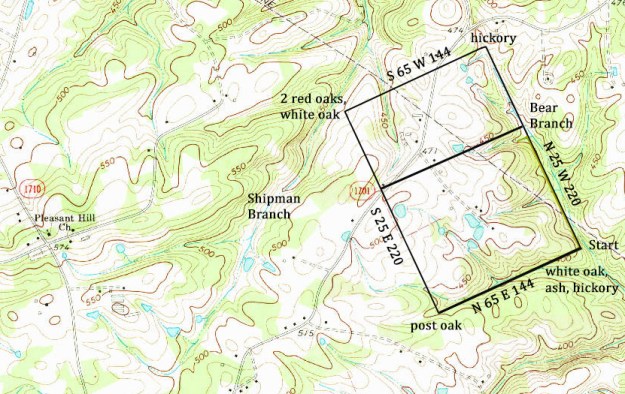
 Dated 23 Nov 1801 and as identified in the above plat, William Gurley received a Secretary of State land grant (5643 Anson NC for 200 acres situated on Bear Branch. The survey identified the land as lying between Shipman Branch and Bear Branch which are also identifed in the above plat. Chainbearers for the survey were Leonard Musselwhite and Willis Gurley.
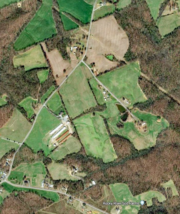
I love it when old grants and deeds can be located on present day maps. Take a look at the following Google image and see if you can locate William Gurley’s 1801 grant:
After receiving this grant it’s not long before William Gurley dies as his last will and testament was recorded in Oct 1804 (See bottom of page for the last will and testament). William Gurley’s widow Millinder and their older girls Elizabeth (Austin), Sarah (Lauhorn), Jean (Pool), and Charlotty Austin are clearly defined in the will. At the end of the will you’ll see mention of two other girls named Darcass and Ferrabee. Younger and at that time unmarried, the two received slaves and household items needed to start a new life. They also were to divide 500 acres of land on Bair Branch and Shipmon’s Branch:
Item I gave and bequeath to my Daughter Darcass one Negro man Called Tom one three year old heffer one two year old mair one Feather bed formerly called hers together with the stead and furneture thereto belonging one Flax Wheels one Dish one bacon two plaits three Delph plaits one Iron pot two weavers Slays also five hundred Acres of land lying together on the Bair branch and the Shipmons branch which sd Land I will to be Equally Divided between sd Daughters Darkess and Ferrebee.
Item I gave and bequeath to Daughter Ferrabee one Negro man called Jack one Mare Coalt one Cow and Calf twelve geese one cotton wheel and cards one small dish and large bacon one puter plate three Delph plaits one Dutch oven two weavers Slay also two hundred and fifty Acres of Land above mentioned one Cow hide.
William Gurley’s last will and testament must have been contested as a court ordered division of the estate recorded Oct 1815 appears in deed book P, page 261:

Shaded gray above, Benjamin Thomas (for his wife) drew lot number six of the estate being 130 acres of William Gurley’s 200 acre tract. And, drawing lot number 5, Drury Austin received two tracts including the remaining 70 acre northern portion of William Gurley’s200 acre tract. Note from the will that the land on Bear Creek should be 500 acres but in actuality is only 200 acres. And note from the will that the tract had been ordered to be divided between two daughters Pherabee and Darcass. However, the 1815 division gives land to Drury Austin whom we know married daughter Elizabeth Gurley. Looking at the attached estate plat, you can get a better idea of William Gurley’s estate lands:
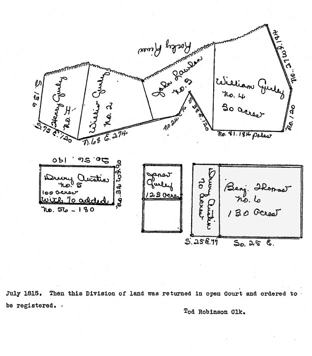
It’s been widely thought that tract number 6 was bequeathed to Benjamin Thomas Senior. However, Benjamin Senior was much older making me question the age differential between husband and wife. Besides that, shortly after the division, on 11 Oct 1818, Benjamin Thomas Junior divested himself of the land by selling the 130 acre tract to William Morris of Mecklenburg County (Deed S-152 Anson). The transaction was witnessed by Anias Thomas and Jas. Morris. There’s no surviving record of what happened to Drury Austin’s 70 acre portion. We do know that Drury ended up in Lincoln County Tennessee with his brother Michael.
Let’s take a look at a few other pieces of land acquired by William Gurley.

Dated 25 Jul 1774, Solomon Townsend received land grant (3629, Anson NC in yellow) for 100 acres near the mouth of a small branch (likely being Shipman’s Branch). On 6 Jul 1779 Solomon sold the land to Middleton Pool with witnesses being William Brooks and William Bennett Senior. And then on 28 Feb 1782 Middleton Pool in turn sold the land to William Gurley with witnesses being Jacob Green and John Austin.
Dated 14 Oct 1783, Middleton Pool also acquired land grant 4382 (in green). Being 50 acres, Middleton sold this tract to William Gurley on 10 Aug 1787 (Deed D-272, Anson NC). Witnesses were Willis Gurley and Joseph (x) Johnson.
On 9 Mar 1799 William Gurley received a Secretary of State land grant (5333 Anson NC) for 250 acres situated on Rocky River. Note that this grant captured or surrounded the lands that William Gurley had earlier purchased of Middleton Pool.
One other tract granted to William Gurley ( 5674 Anson NC) was issued on 30 Aug 1802. Per his will and as recorded in deed book S, page 118, on 6 Apr 1815 William Gurley of Anson sold this tract to his son Willis Gurley. Witnesses were Thomas Vann and Benjamin Thomas Senr. And then apparently taking the monetary gains and moving west, on 13 Oct 1819 Willis Gurley sold the tract to David Cagle of Cabarrus (V-307 Anson NC). Witnesses were Benjamin Thomas and J. B Skinner.
Well after the death of William Gurley, Benjamin Thomas received a land grant for 300 acres (6702 Anson NC) situated against the said Gurley’s land on the Shop House Branch. Was this Shop House or should it have been Shipman? Also, is this Benjamin Thomas Senior or his son of same name who we now know married a daughter of William Gurley? Let’s look back to William Gurley’s estate plat, adding that information to what we now know of William Gurley’s land on the Rocky River.
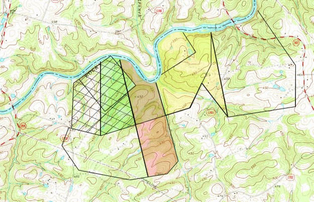
Looking at the above, and as surveyed for William Gurley’s widow Millinder, the dower tract is identified by hash marks. The yellow shaded area to the right fell into the hands of John Laughorn who married Sarah Gurley. Then, on 11 Jan 1817, William Hammond Esq. Sher. sold the tract to Willis Gurley by virtue of an execution against Sally Laughorn. Witnesses were William Gurley and Benjamin Thomas. The green shaded area fell into the hands of Willis Gurley per the estate of William Gurley. Then on 1 Sep 1815, almost immediately after receiving the land from William Gurley’s estate division, Willis Gurley sold that tract to Benjamin Thomas (R-90 Anson NC). And, to the left of the green shaded tract is an unshaded area falling within the widow’s tract. Drawn by son Henry Gurley, dated 27 May 1817, Henry Gurley now of now Haywood County NC sold his land to Benjamin Thomas Junior (S-168 Anson NC0. John Austin and Jac. Austin witnessed the transaction. So by 1817 Benjamin Thomas had a grant to the south of the Gurley land and had bought out the estate lands along the river to his north.
Dated 22 Jan 1835, being just a short time prior to penning his last will and testament, Benjamin Thomas Junior deeded 200 acres (Z-136 Anson NC) to his son Jacob Thomas. For love and affection, the gifted land was part of two tracts. And, helping to locate the land, one of the short lines on the south side crossed Shipman’s Branch. Also, one of the back lines for this tract adjoined a line marking Benjamin Thomas’ 300 acres. Because the 300 acre tract was granted to Benjamin Thomas Junior, it’s my belief we are looking at Benjamin Junior and his son Jacob.
Benjamin’s wife, who I think to be Darcass Gurley, died shortly after 1820. Prior to 1830, Benjamin Junior married second Elizabeth Brown Traywick to whom was born a son Jesse Green Thomas. In a letter written home during the civil war, Jesse pleads for a letter from “Jacob.” I believe that Jacob is Jesse’s half-brother born to Darcass Gurley.
________________________________________
Last Will and Testament of William Gurley
In the name of God Amen I, William Gurley of the State of North Carolina and County of Anson Being in Perfect mind and Memory Dothe Make this my Last will and testament and calling to mind the Mortality of my Body and knowing that is is appointed for all men once to Die I first recomend my Sole to God hath gave it and my body to be Berried in such a place as my Executor shall hereafter appoint and now for Setteling my tempora Estate
I do gave and bequeath in the manner following first I will that all my Just Debts be payed out to my Estate
Item I gave and bequeath to my wife Millinder three hundred acres of Land on River between Willie Gurley Laine and the mouth of Shipmons branch Containing the plantation where on I now live together with all improvements and prfits thereon belonging also all my plantation tools such as plows hoes axes & also all my carpenters tools one large bacon the Largest Dish and three plates together with all the knives forks and spoons one feather bed stead and furniture three weavers stays one flax wheel all the water vessels barrels casks &c one Iron pot one skillet also one black mair two Read culred cows and three calfs one three year old bull one three year steer five three year old barrows ten two year olds belonging to the same gang and three sows and all the piggs belonging to them one weavers loom one cotton wheel six chears five Reap hook together with Sundry articles of small value belonging about the house one Negro woman called Fillas Durin her widowhood then to be sold and her & Value Equaly Divided between my three Eldest Daughters namely Elizabeth Austin Jaen Pool and Sarah Lauhon also one yearling bull and three sheep also the half of all the unmarked hoggs and hand Mill also two kids and three Sids of leather to gether some other Remnant also my Saddle and bridle also my Clothes hat and five bee hives
Item I give and bequeath to my Eldest daughter Elizabeth two cows and Calf and the yearling to one of sd. cows calfs I will and bequeath to Charloty Austin also I will to my Daughter Elizabeth Six two year old hoggs Useing about the hors pen lic also one small hide of leather
Item I give and bequeath to my Daughter Jean one Cow and Calf also three two year old hoggs Spaid Sows and Barrow belonging to the Laughon Gang, also two hundred and fifty acres of land on the Watery Branch to be Equally Divided between her three boys Alexander Pool and William Pool and Nathan Pool also the smallest sid of leather
Item I gave and bequeath to my Daughter Sarah one cow and Calf and one heiffer now in her possession also two Sows and their Shote and foure tow year old hoggs also two hundred Acres of land joining Leonard Musslewhites Loine including the Miry Spring also an Entry adjoining John Laughon also one side of Leather
Item I give and bequeath to my Eldest Son James Gurley one hundred Acres of land including the oak pond also one bull one Whipsaw and pile.Item I gave and bequeath to my Sone Willis Gurley foure hundred Acres of Land if there is as much after the tree hundred already given is run out Lying out towards Muslewhite also my blacksmith and Coopers tools and one half of the unmarked hoggs also an Entry of LAnd joining his own Laine also all the jointing and plaining Stocks
Item I give and bequeath to my son William Gurley all Lands to me belonging below the Mouth of Shipmon’s Branch one Molatto man called Csar one 1 horse one three year old heaffer two sows and nine Shots one feather bed that was formerly Calld his together with the Stid and furniture thereto belonging also my Shoe making tools also one musket gun also one Iron pot one BeehiveItem I gave and bequeath to my Daughter Darcass one Negro man Called Tom one three year old heffer one two year old mair one Feather bed formerly called hers together with the stead and furneture thereto belonging one Flax Wheels one Dish one bacon two plaits three Delph plaits one Iron pot two weavers Slays also five hundred Acres of land lying together on the Bair branch and the Shipmons branch which sd Land I will to be Equally Divided between sd Daughters Darkess and Ferrebee
Item I gave and bequeath to Daughter Ferrabee one Negro man called JAck one Mare Coalt one Cow and Calf twelve geese one cotton wheel and cards one small dish and large bacon one puter plate three Delph plaits one Dutch oven two weavers Slay allso two hundred and fifty Acres of Land above mentioned one Cow hide
Item I gave and bequeath to these my Executors Willis Gurley and Leaonard Musslewhite three heffers and three sids of Leather one black some parts three year old another white and another brinded these to be sold to satisfy my just Debts.
also I do Nominate Constitute and appoint the afore sd. Willess Gurley and Leonard Muslewhite to be my hole and sole Executors of theis my last will and Testament as
Signed sealed and Delivered before us
Witness My hand and Seal
Test William
Gurley (Seal)
Richd Austin
William Gurley Junr
Willis gurley
Leonard (X) Musslewhite
Executors to the written will____________________________
State of North Carolina
Anson County October Sess 1804
The written will was duly aproved in open court by the oath
of Richd Austin a witness thereto and ordered to be Recorded
 Stationed in Wilmington during the summer of 1862, Jesse Green Thomas was there in service of CSA Co. C. 10th Battalion NC. Better known as the Monroe Heavy Artillery, the unit was responsible for garrison duty along with the construction of defense works surrounding the port of Wilmington. Can you imagine the swampy lowlands and of the six mile long earthen breast works dotted with military encampments ? Imagine the excessive heat, the blood and sweat, and the never ending presence of mosquitos. It was in this environment where the young Jesse Green met his fate.

 It appears Jesse Green Thomas was among those who fell in what later grew to become an epidemic spread of Yellow Fever. In his letters he wrote mostly of care given in hospital as well as of his appreciation of good treatment while recovering at the home of an unnamed local resident. And written with greater urgency and a growing sense of despair, the last letter penned in early August foretells of Jesse’s ultimate demise. According to cemetery records we know that

 A matter of curiosity to me, it’s noteworthy that the 1862 Yellow Fever burial site is somewhat hidden behind the trees above Oakdale cemetery’s Jewish section. With no proof to make the claim, I’d think the Yellow Fever section is primarily the site where those buried are mostly townsfolk. Across the vast cemetery, on the other side, is a large earthen mound capped with a
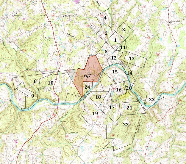


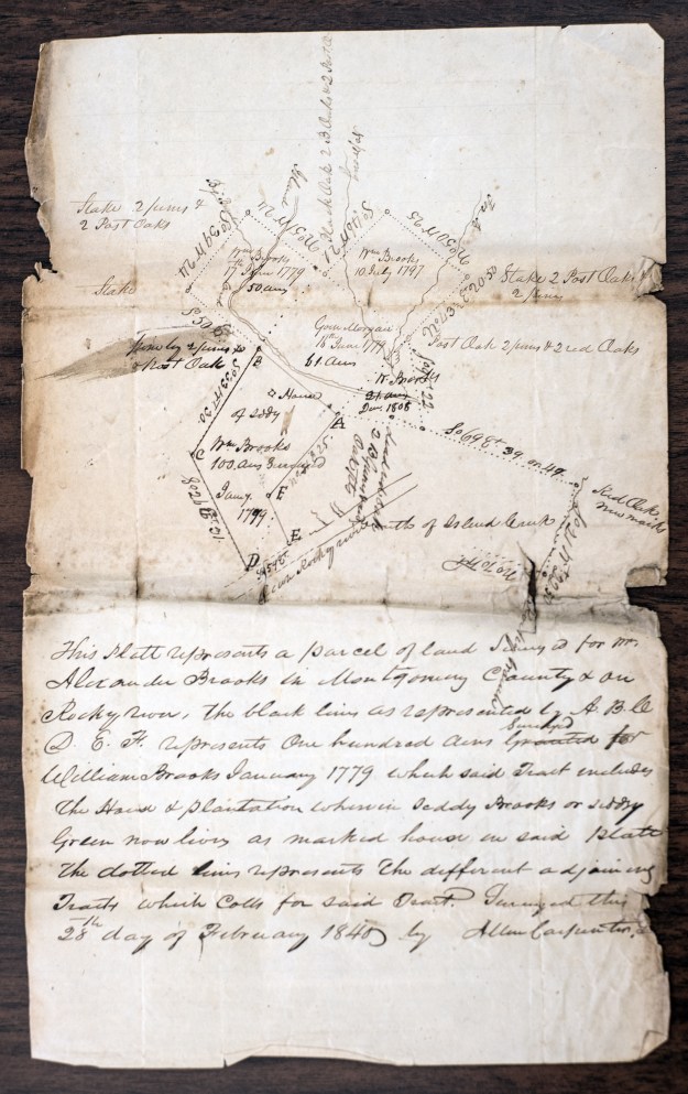
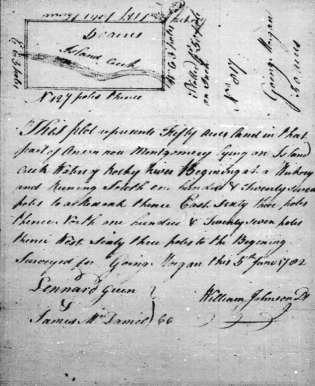
 (YELLOW TRACT) Starting in 1770, Goin Morgan acquired several grants in Anson County (now Montgomery) on the Baptist Prong of Clark’s Creek. Located across the Pee Dee River between the river and the present day town of Troy, this area may have been connected to what was known as Little River Baptist Church. It’s one of the oldest Baptist churches in the southern piedmont. This intermediate stop in migration was likely taken by others who also spread south across the state.
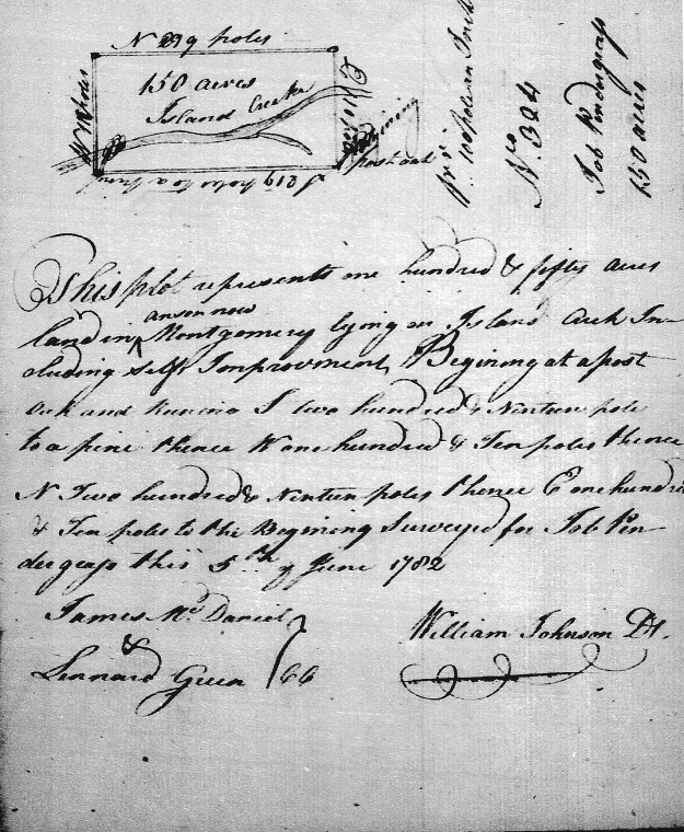
 PURPLE TRACT) Entered and issued on the same dates as Morgan’s above 50 acre grant, William Brooks also received a grant for 50 acres [Grant 88, Montgomery NC]. Situated on Island Creek [including the fork of Big Branch], this land adjoined his own and that of Goin Morgan. Chainbearers from William Morgan’s survey were John Austin and Bryant Austin.
 (GRAY TRACT) Entered 31 Oct 1794 and issued 10 Jul 1797, William Brooks received another 50 acres [Grant 1034, Montgomery NC] adjoining his own land. This land crosses both the Big Branch and Fox Branch. Chainbearers were Jno Brooks and Jonathan Whitley.
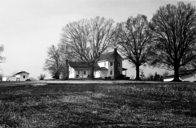
 (RED TRACT) Being the tract upon which the Brooks-Hill House stands, 100 acres (Grant 125, Montgomery NC) issued to Capt. Wm. Brooks were entered 20 Nov 1782 and issued 11 Oct 1783. However, the grant’s survey is dated 16 Jun 1779 which predates the entry and somewhat matches Allen Carpenter’s mapping at the top of the page. Note that this tract adjoins Rocky River and the lands of Wm. Brooks. Chainbearers for the grant were Goin Morgan and Arthur Pool.
 (GREEN TRACT) Acquired much later, William Brooks entered 21 acres on 5 Jan 1808. The grant [Grant 1912, Montgomery NC] was issued a few years later on 6 Jul 1812. According to the 16 Sep 1808 survey, the tract adjoined the lands of William Brooks as well as that of William Thornton. This is a really cool note in that William Thornton was the designer of the United States Capitol Building. He was also the father of the US Patent Office and his wife Anna Maria journaled the burning of Washington during the War of 1812. Anna Maria Thornton was good friends with Martha Washington and Dolly Madison. She stood before Congress where she pleaded on behalf of Martha that George be interred at Mt. Vernon rather than at the new monument bearing his name.
 (LIGHT BLUE TRACT) The information on this tract is vague and not properly identified in terms of date or acreage. There must be good reasons for that. It appears in the survey that the tract crosses over Rocky River. And yet, the southeast side of the tract is marked showing it may merely join the river …or is that another stream? Looking through all the land grants issued to William and John Brooks as well as Goin Morgan, I only found one [Grant 999, Montgomery NC] with similar meets and bounds. However, in patent Book, 94 Page 62, the 10 Jul 1797 issuance description for Grant 999, Montgomery NC has an error and cannot be platted. The entry includes similar metes and bounds running north to south at 70 degrees as well as north to east at 20 degrees. The patent also indicates that the grant adjoins the lands of William Brooks and is situated on the waters of Island Creek.
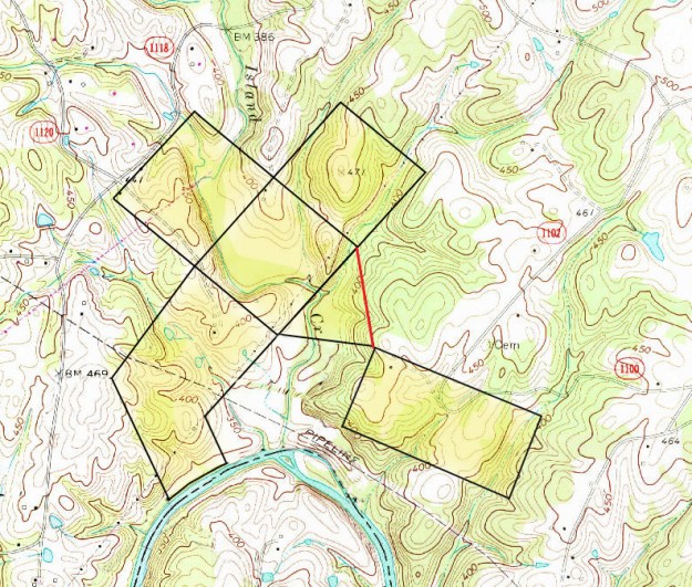

 I love driving home to Charlotte on the old two-lane Highways 64 and 49. It may be quicker to take I-85, but then again there’s the heavy traffic, pile-ups, and the void of anything beautiful. And, you must realize that the old way is changing fast. Lanes are being added every day and what were once small little towns are now extending their limits. So, let’s look back to the day and time when I was a college student in the late 70’s. What was it like back then to make the journey home for a weekend with family?
 Passing at 15mph around the
  flapping sound of overhead drive belts powered by a large 14 hp electric motor. There were swing saws and other woodworking equipment of the like I had never seen. Mr. Wright had flipped a 24” planer, transforming it into the widest jointer I’d ever seen. All I could think in seeing this was …Good God All Mighty! Mr. Wright was missing at least three fingers though his display and sales area were always filled with the finest woodworking.
 West of Asheboro, Hwy 49 splits off of Hwy 64 and heads southwest through the decaying mountain range called the Uwharries. Out in the middle of nowhere the road widens beautifully to four lanes through pastoral farmlands. The widened road is a stone’s throw from the town of Denton where is held the Annual Doyle Lawson Bluegrass Festival and Old Time Fly-In Threshers’ Reunion. On several occasions I timed my trips home to enjoy the summer festivities.
 mes were rough and my dad learned a lot about entrepreneurship as he didn’t sell enough to even pay his transportation. But, years later at NC State I had the chance to work at the University Crafts Center with student Marlow Gates whose story turned out much different.
 Just across the street and up a ways from Fine’s Broom Company an ancient stone wall appears out of the passing forest. Holding up an ancient roadbed from the ravages of a creek, the wall’s purpose is disguised by thicket and overgrowth as it disappears into the adjoining woods. Just as old 49 Hwy has been replaced by Interstate 85/40, there was once an even older road winding its way parallel to Hwy 49. It’s amazing what you’ll learn if only you let your eyes see things for the time they existed.
 antebellum hoop dresses, Barbie-like baby dolls were transformed into the perfect bedroom accent suited for the most tasteful southern lady. And yet, there was something odd about what I saw. Here was this lady only a generation or two out of slavery perpetuating the cast system from which her family had been freed. And yet, she appeared happy to be making her own money freely by the commands of her own hand. I often wanted to stop by and talk to the lady, to photograph her along with her wayside sales display. I can still see the sign on cardboard “Piller Dolls $10.00.” I’d love to carve a sculptural piece in memory of this old vision.
 Atop this hill crest crosses the old Concord Road and near the intersection stands

 Driving a bit further, I passed over Richardson Creek where I saw a stately old farm house standing near the intersection of Thomas Road. With miles to go and my day not yet done, I regretfully overlooked the need to photograph the old home. So, a big thank you goes out to Mr Yellow Google Man for capturing the image to the right.
 Before moving on a little needs to be said about the unit in which Calvin served. At Gettysburg but a few short feet from the base of a wall infamously known as the Angle stands a simple monument placed by the State of North Carolina. Marking the falling point of the furthest advance by any Confederate regiment engaged at Gettysburg, the pink granite stone locates the position where Calvin’ 26th Regiment fell in battle. It’s a story for historians and continues to be held up as a very important achievement though research shows the claim may have been made in error. I’ve had the chance to visit Gettysburg and in doing so put together
  Heading north on Hwy 742 from Calvin Thomas’ home place, I turned almost immediately right onto Thomas Road and soon-after to the left onto an unmarked gravel road known as Carpenter Road Extension. On the day of my trip I passed by a house deep in the woods doing all it could to hide from my sight. And, down the hill and around the slope of a hill was the final destination of my day’s drive.


 I’m not talking about some local parcel of land being here in North Carolina. For the first time to my knowledge, I can now get a free look at land anywhere I wish within the boundaries of the United States! You see, for many years as a backpacking enthusiast, scout master, and now as one who loves family history; I’ve always visited the Archdale Building here in Raleigh in preparation for my outdoor adventures. Topography maps purchased for around $10 give the best view of landscape including trails and elevation. And in terms of family history, they locate cemeteries as well as creeks and small paths. The maps are a must for those who need a close look at land and how it’s used.