
The legal case of Alexander Brooks vs. Siddy (Green) Brooks was introduced in my last post. There was also the related survey found among the loose ejectment papers in Stanly County. In this post the land grants making up the survey will be discussed in greater depth. And note that each tract of land has been colorized so that you’ll have an easier time identifying them:
 (YELLOW TRACT) Starting in 1770, Goin Morgan acquired several grants in Anson County (now Montgomery) on the Baptist Prong of Clark’s Creek. Located across the Pee Dee River between the river and the present day town of Troy, this area may have been connected to what was known as Little River Baptist Church. It’s one of the oldest Baptist churches in the southern piedmont. This intermediate stop in migration was likely taken by others who also spread south across the state.
Within ten years Goin had picked up and moved again. By 1779 he was acquiring land on the north side of Rocky River on the western side of Island Creek. Entered 10 Dec 1779 and issued Oct 1783, Goin Morgan received 50 acres [Grant 258, Montgomery NC] on both sides of Island Creek in what’s now Stanly County. The survey was made 16 June 1779 which matches the date in Allen Carpenter’s 1849 survey. It’s interesting that the original surveyor in 1779 was named Mark Allen. Note also that according to Allen Carpenter’s survey, the western boundary of this tract runs between the Brooks-Hill house and Island Creek. Goin Morgan and Arthur Poole served as chainbearers, meaning they were there and present to carry the measuring chains and equipment for the surveyor.
( PURPLE TRACT) Entered and issued on the same dates as Morgan’s above 50 acre grant, William Brooks also received a grant for 50 acres [Grant 88, Montgomery NC]. Situated on Island Creek [including the fork of Big Branch], this land adjoined his own and that of Goin Morgan. Chainbearers from William Morgan’s survey were John Austin and Bryant Austin.
 (GRAY TRACT) Entered 31 Oct 1794 and issued 10 Jul 1797, William Brooks received another 50 acres [Grant 1034, Montgomery NC] adjoining his own land. This land crosses both the Big Branch and Fox Branch. Chainbearers were Jno Brooks and Jonathan Whitley.
 (RED TRACT) Being the tract upon which the Brooks-Hill House stands, 100 acres (Grant 125, Montgomery NC) issued to Capt. Wm. Brooks were entered 20 Nov 1782 and issued 11 Oct 1783. However, the grant’s survey is dated 16 Jun 1779 which predates the entry and somewhat matches Allen Carpenter’s mapping at the top of the page. Note that this tract adjoins Rocky River and the lands of Wm. Brooks. Chainbearers for the grant were Goin Morgan and Arthur Pool.
 (GREEN TRACT) Acquired much later, William Brooks entered 21 acres on 5 Jan 1808. The grant [Grant 1912, Montgomery NC] was issued a few years later on 6 Jul 1812. According to the 16 Sep 1808 survey, the tract adjoined the lands of William Brooks as well as that of William Thornton. This is a really cool note in that William Thornton was the designer of the United States Capitol Building. He was also the father of the US Patent Office and his wife Anna Maria journaled the burning of Washington during the War of 1812. Anna Maria Thornton was good friends with Martha Washington and Dolly Madison. She stood before Congress where she pleaded on behalf of Martha that George be interred at Mt. Vernon rather than at the new monument bearing his name.
Hearing of gold in North Carolina, William Thornton purchased approximately 67,000 acres taking up most of what’s now the interior of present day Stanly County. Thornton purchased the huge acreage from John Carson who as a land speculator had earlier bought out partners William Moore and Thomas Carson. The three had purchased a large break-up portion of one of Arthur Dobbs’ 100,000 acres Great Tracts. Unsold portions of the land reverted to the state following Dobb’s death. His heirs had fought to continue receiving payment from those residing on the land. Known as quit rent, the tax like charge had been assessed for many years in order to display power over the citizens. And prior to Dobb’s purchase of the Great Tracts, there were but a few settlers living in the back country of North Carolina. Many of those had wrongly purchased their land through the Governor of South Carolina. As you can image, that hit the fan and all was made good when the King of England weighed in between the Governors of North Carolina and South Carolina. Whew! …all that gleaned from a 21 acres grant!
 (LIGHT BLUE TRACT) The information on this tract is vague and not properly identified in terms of date or acreage. There must be good reasons for that. It appears in the survey that the tract crosses over Rocky River. And yet, the southeast side of the tract is marked showing it may merely join the river …or is that another stream? Looking through all the land grants issued to William and John Brooks as well as Goin Morgan, I only found one [Grant 999, Montgomery NC] with similar meets and bounds. However, in patent Book, 94 Page 62, the 10 Jul 1797 issuance description for Grant 999, Montgomery NC has an error and cannot be platted. The entry includes similar metes and bounds running north to south at 70 degrees as well as north to east at 20 degrees. The patent also indicates that the grant adjoins the lands of William Brooks and is situated on the waters of Island Creek.
Now, to confuse the matter, the shape of the grant survey dated 30 Mar 1796 matches the shape of that in the 1848 plat drawn by Allen Carpenter. The lengths and directions of the lines work though only two lines are described with the third and last line running back to the start for completion. You can’t make that work! The survey indicates the tract is located on the waters of Island Creek adjoining his own line. However, unlike the patent, the survey plat for Grant 999 indicates one side runs along “Rocky Branch.” Chain bearers are Exodus Whitley and Jonathan Whitley.
The tracts identified in the 1848 survey made by Allen Carpenter only account for a portion of the lands of William Brooks. There are more land grants and even local conveyances of land purchased from others. For now, I’m leaving you with my own platting of the grants as identified in the 1848 survey. However, the following is based on the metes and bounds taken from Secretary of State land grant records. They are also overlaid upon a recent topographic map providing a better idea on where the lands are located.
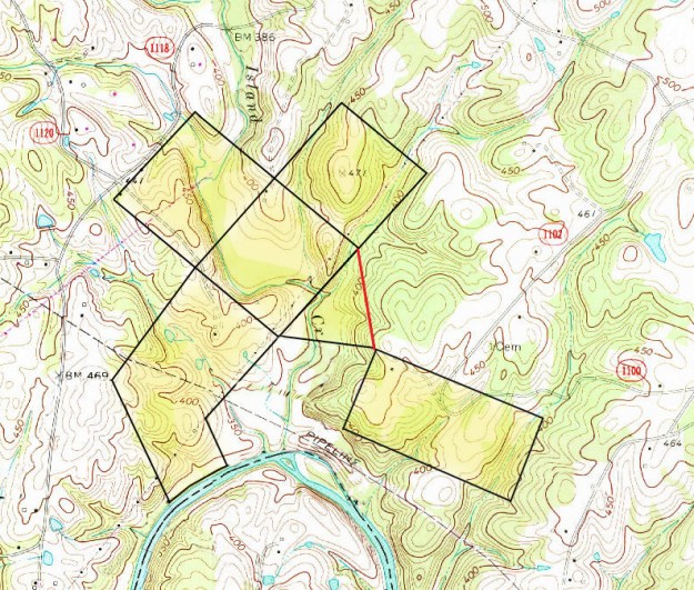
Realize that all of the above are land grants supported by proper survey and documentation providing a greater sense of provenance or title history. Note there is one line above drawn in red …see it? That line, as described in the grant, adjoins William Thornton’s land. We know that Thornton’s land originates in the breakup of Arthur Dobb’s 100,000 acre Great Tract through purchases and not as much grants. There’s little supporting documentation and with the 1830’s burning of the Montgomery County Courthouse, much of what was once available is now gone.
Would you like to see a bit of the Great Tract and what its impact on the area looked like? Take a look at the grant survey below:

Grant (No. 772, Montgomery County NC) 17,820 – 17880 acres.
Entered 2 Nov 1794, Surveyed 16 Dec 1794, Issued 11 May 1795
Issued to Thomas Carson and William Moore
By virtue of 27 warrants of 640 acres each with one being 600 acres, land lying in the Forks of Rocky River and Long Creek and Bear Creek.
Excluding lands within the survey owned by the following: Thomas Larron 150 acres, Bozman Adare 150, John Smith 150, James Exum 200, Bryan Whitfield 150, Exodus Whitley 250, George Cagle 425, David Cagle 150, Lewis Whitfield 100, John Morrison 150, Edmond Lilly 200, Simms Metheney 100, Jesse Gilbert 150, Christopher Cagle 100, John Cress 300, Alexander Pool 106, Saunders Pool 100, William Phillips 50, William Brooks 400, John Brooks 150, Samuel Fratwell 100, Spencer Self 120, William Witherspoon 101, John Hartsell 100, John Blackwilder 100, Valentine Cagle 150, Charles Cagle100, James Bankston 200, and John Christian 4375Enter a caption
The above is but a part of one of four grants issued to Thomas Carson and William Moore. The portion in yellow are the lands of Carson and Moore and it was Carson who sold out to Thornton. You also see Island Creek near the bottom and to the east or right hand side you see metes and lines indicating exclusion of pieces of land already owned by others. And, as written into the grant, William Brooks owned 400 acres and John Brooks owned 150 at the time of the grant issuance. It’s also vitally important to see where others are identified in relation to where we know William Brooks once lived.
As you’ll see in the next post, the above provides a great starting point for anchoring other tracts up and down and across the river. In the next post additional tracts will be added to the map including surnames like Austin, Morgan, Lauhorn, and Green. The legal descriptions will be provided for both the new grants as well as those we learned about from the 1848 survey.

The old Polk Ford Road appears in several early maps though the best is from a compilation I made of large grants that ca. 1804 fell into the hands of William Thornton, designer of the United States Capital. It’s at the top of this page: http://www.angelfire.com/nc/benjthomasofansonnc/stanly.html
Also, here’s one of Mecklenburg showing the road running the route of today’s Brief Road and to the ford at the mouth of Clear Creek: https://dc.lib.unc.edu/cdm/singleitem/collection/ncmaps/id/155/rec/1
Here is an article I wrote on the 1771 act to create the road and of later iterations moving the road first up passing south of Bethel UMC in Midland and later to today’s route north of the church. https://rockyrivernc.com/2014/10/06/our-state-has-a-new-roads/