In April of 1844, William Holland Thomas, on behalf of Bonner Byrd, “came before a J.P. of Haywood County concerning a claim for a pension for services during the Revolutionary War.” The resulting deposition reached the desk of representative T. S. Clingman in Washington County, District of Columbia where we learn the said Bonner Byrd was, at that time, “upwards of ninety years of age …my impression is he stated he was ninety-four” and living with his son Thomas W. Byrd “about half a mile from Qualla Town.”
From his enlistment in 1776 as outlined in his services protecting the Georgia frontier from Indians, Bonner Byrd deposes that following his discharge, he “moved to Halifax County Virginia,” “he was born in Bertie County, North Carolina, [and] moved from Virginia to Montgomery County, North Carolina.” He alludes to the possibility that at the time of enlistment he may have lived in York District, South Carolina. One would assume this timeline of events to be accurate though the actual migratory path may have included intermediate stops along life’s way. To this idea Bonner Byrd appears in 1790 Wake County where many online genealogies show him to be the son of Edmond Byrd. I’m George Thomas and I am a hesitant believer.
Shortly after 1790, Bonner Byrd shows up in the annals of Mecklenburg and its offshoot, Cabarrus County, North Carolina. And though he shares very little detail of that area, Bonner’s military pension request includes the following 1810 petition for pension application signed by neighbors:
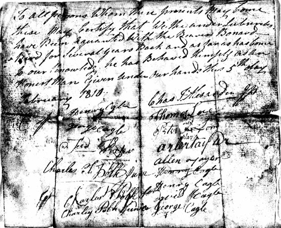
To all persons whom these presents may come these may certify that we, the under subscribers have been acquainted with the ——- Bonnard Bird for several years back and as far as has come to our knowledge, he has behaved himself as and honest man Given under hour hands the 5th Day of February 1810. Henery Cagle Charles T. Alexander George Cagle Thomas Love Fred. Keiser Peter (X) Long Charles T. Polk Jun Artur Taylor Charles Polk Sen Henry Cagle Charles Polk Junior David Cagle George Cagle (Additional signatures) William Polk John Cobul John Carothers Gideon Freeman
 Bonner Byrd resettled in Haywood County during the 1810s, being the time others also made moves west. Among those were William Bugg who served in the War from Wake County. Also having lived nearby in Cabarrus County, friends and neighbors Jacob Smith and John Howell deposed: “that we believe him to be the age stated in his declaration, that he is ——- & — lived in the neighborhood to have been a soldier of the revolution and that we concur in that opinion.” The pension file is large and descriptive though Bonner Byrd states that his discharge and other records were lost when his home was “carried away by the river.”
Given the quick tour of Bonner Byrd’s military background, I now would like to draw attention to a piece of his land in present day Cabarrus County. Note that the following is far from complete as at some point I must return to other neighboring tracts once owned by Bonner Byrd …including land he sold to Thomas Ingram, the brother-in-law of my maternal ancestor James Love who were both born in Brunswick County, Virginia. For now, I find it intriguing how Bonner and others from Wake County decided to settle in the general vicinity where gold was first discovered by Europeans in America. And as will be shown, among this mix is also the fellow Thomas Barker who has been dogging my research efforts for quite some time.

Having passed east of Rocky River on Highway 24/27, one will almost immediately come upon an intersection where stands the North Carolina State historical marker for Reed Gold Mine. Turn left onto Reed Mine Road and the old mine site is but a few miles away. There, visitors are given access to the old mining shaft, a museum, and trails through the old estate where the nearby John Reed family cemetery quietly tells its story. Most tourists likely walk away thinking John Reed’s family settled on the surrounding lands though one needs to return to the intersection at Highway 24/27 to learn more of goldminer John Reed’s children. South of the intersection, Reed Mine Road becomes Pine Bluff Road upon which this writing takes place. And it’s there, straddling both Stanly and Cabarrus Counties, where young Conrad Reed did settle and die.
Conrad happens to be John Reed’s little son we have all heard about who famously discovered gold in America whilst playing in nearby Little Meadow Creek. And keeping it in the family, Conrad married Martha Love, whose brother Jonah happens to be my mother’s ancestor. But also living on Pine Bluff Road on land adjoining Conrad and Martha Love Reed were the said Conrad’s brothers James, Henry, George, and John. And driven by the understanding of events and area land acquisitions well before the siblings came of age, for me the story of early settlement begins to unfold. The remainder of this writing concerns platted land, community, and ultimately a person named Thomas Barker who settled near the Reed family along with others who made their way from Wake County.
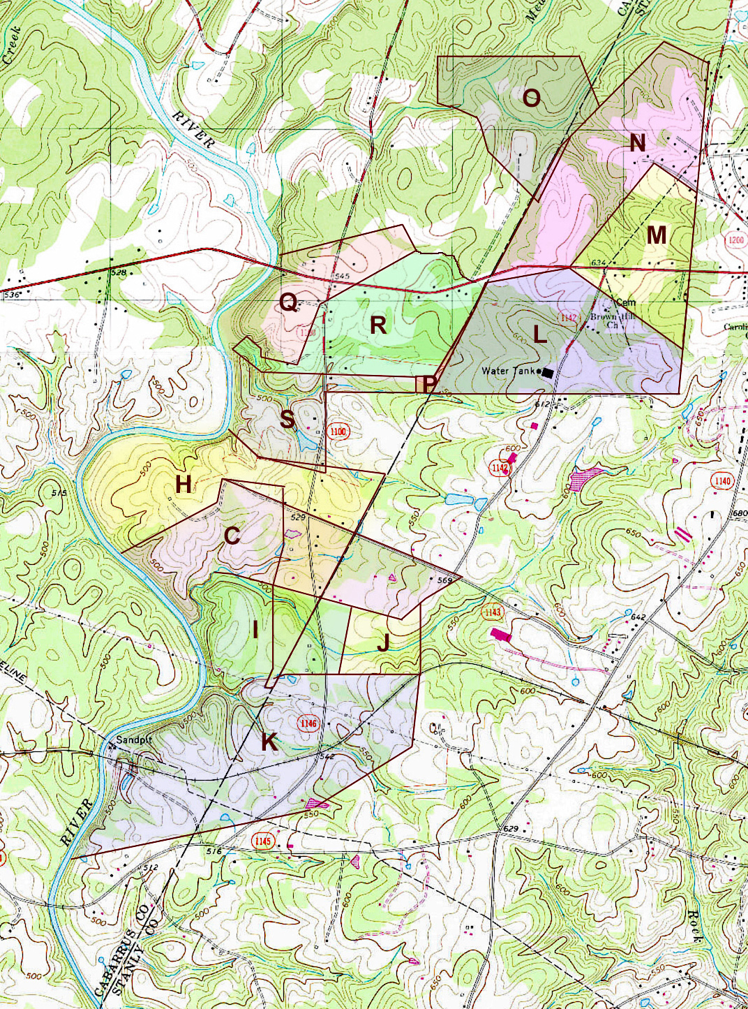
In the image below, notice the southerly course of Rocky River, the intersection, and Pine Bluff Road which heads off to the south. Mingling among the contour lines, one can see Reedy and Howell Branches entering the river from the east. Note also that Howell Branch is named for Joseph Howell who settled in the area after leaving family beginnings far to the northeast in Edgecombe County. Joseph is the father of John Howell who spoke on behalf of Bonner Byrd in the wilds of Haywood County. Also, notice the five tracts of land below that I’ve platted for you to study.

Undated (likely 1771-1774) and filed in then Mecklenburg County (Deed 10-544), Thomas Polk, attorney for David Oliphant, sold Tract A to Peter Kizer. At that time the extreme southeastern line of the 22 acres was said to join that belonging to “Hall Powell.” Note that goldminer John Reed married Sarah, the daughter of Peter and Fanny Keiser.
Earlier, in 1771, George Crowell came to settle next door as he purchased Tract B (80 acres) from Gov. Abner Nash and wife Justina (deed 6-50, Mecklenburg). The young Justina married earlier to Royal Governor Sir Arthur Dobbs who controlled all the 100,000-acre Great Tract 5 and a portion of the adjoining Tract 2 upon which the lands I am writing about are a part. See image below. And following the 1765 death of Gov. Dobbs, his widow Justina married Abner Nash who himself became Governor in 1780 during the height of the Revolutionary War. Much of the land in Tract 2 was sold by deed by agents of Dobbs and Nash until the Revolutionary War when the new government confiscated lands owned by Tories for sale to construct the University of North Carolina.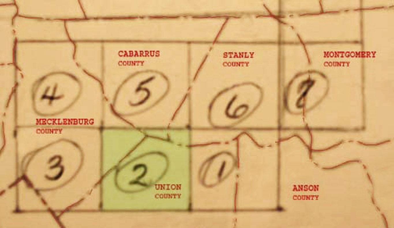
As for Peter Kizer’s 20+ acre Tract A, in 1799 Cabarrus County, John Keiser of Knoxville, Tennessee, sold that piece of land to George Keiser [Kizer] by way of attorney John Culpepper (Deed 3-172, Cabarrus). And in 1811, George Keiser turned around and sold both the 20+ acres Kizer tract and the 80-acre Crowell tract to John Keiser, who, from the conveyance, appears to have returned to Cabarrus County. Had John Keiser explored opportunities to the west and maybe returned following word of gold?
Adjoining the 80-acre tract is the 58-acre Tract C purchased in 1773 from Thomas Polk, attorney of David Oliphant (deed 10-548, Mecklenburg). Next, in 1812, Robert McMurray, Esq., Sherriff of Mecklenburg County, sold Tract D to John Kiser (deed 8-107, Cabarrus). Note the legal description of Tract D locates that piece of land partially on top of the 80-acre Tract B.
In 1811, Sheriff Robert McMurray sold to William Weddington 130 acres, being Tract E, which at that time was said to join John Kiser to the west and Mark Kiser to the north (Deed 8-103, Cabarrus). Also, note that the southwest corner of this tract ran along a small branch which we will later learn was called Howell’s Branch.
To the North of William Weddington’s purchase, Mark Keiser also purchased land, Tract F, from Sherriff Robert McMurray. Note the title histories must reach deeper in time as all such sales by the Sherriff resulted from unpaid taxes by earlier owners. As for Mark Keiser’s 66-acre purchase (8-111, Cabarrus), the metes and bounds adjoin the Montgomery (now Stanly) County line to the east, John Keiser land to the southwest, and John Tucker land to the north. Please remember the name John Tucker. Per this deed, the land also shared two western lines with land owned by “Thomas Barker.” Wow! …from a letter against Gov. John Sevier published in the 1802 Tennessee Gazette, Thomas Barker and wife Ann testified in Logan County, Kentucky concerning a family of color once living in Wake County named Lucost who were wrongly enslaved by the Tennessee governor. Thomas Barker, that Thomas Barker, tells of moving from Wake County to a place “beyond the Yadkin.” If, living among the Keiser family, this were the same Thomas Barker, then he was not alone as others in his circle are found owning land near that outlined in this post. Could Thomas Barker in Cabarrus be the same as he who moved to Tennessee? I think not as the timing is way off. Either Thomas Barker in Tennessee and Kentucky was back and forth from here to yonder, or possibly naming patterns and generations of the same Barker family are conflated. And yet, we see here that John Keiser likely made similar moves back and forth to Tennessee. So, not able to resolve the dilemma at this point, let’s continue looking at the broader community in hopes of at least learning a bit about those who lived near the said Thomas Barker. But firstly, I almost forgot to share the “Barker” land indicated in Mark Keiser’s acquisition Let’s now go there.
Looking at Tract G (deed 8-90, Cabarrus), George Keiser sold 30 acres in 1811 to Thomas Barker. See it? That 30-acre piece of land joined John Tucker’s land to the north and Rocky River to the west. Note that both Mark Keiser’s and now Thomas Barker’s land joined that owned by John Tucker to the north. Let’s look at other conveyances within the area before considering the Barker land implications. And as you will see, the shape of land changes with time as owners buy, recombine, and sell their properties. It’s much like DNA research though applied to a completely different animal.
On the map below, note that Tract C is virtually the same land as Tract C above. Note below how Tract H wraps around Tract C from the north and east and how the shape reflects the flow of Reedy Branch. Being 210 acres (deed 9-362 Cabarrus), the land was sold by John Keiser to Henry Reed in 1819. Henry Reed is the son of goldmine owner John Reed and looking closely at the sideways fishhook shaped tract, it’s cool to me that as of 1819 that land incorporated portions of Tracts A, B, C, D, and E above.
Looking closer at Tract C, notice the drawing represents two shapes. The smaller shape already discussed is incorporated in a larger pinkish colored handsaw or hand-gun shaped tract. See it? The larger elongated Tract C spans from the river well across the county line into Stanly County. Deeded in 1828, Frederick Kiser sold the land to Conrad Reed, the fellow who first discovered gold. Metes and bounds describe the long northern extent of the land as being a “division line.” And to the west, against the river, see below where the northern-most line of Tract H runs southwestward to the water? Take a minute to compare that particular line to Tract B as this is the line that once adjoined the property of George Crowell. However, by 1828, at the time of this conveyance, the deed refers to the same line as being the “Catherine Reed line.” Who is Catherine? It turns out that goldminer John Reed’s son Henry died in 1827 meaning this 1828 deed correctly referred to the land as belonging to Henry’s widow who was named Catherine. So, from this deed we learn that Conrad Reed owned land beside his brother Henry. Furthermore, metes and bounds for the gun shaped tract mentions Cheek land to the east and its southwest boundary clearly traces Reedy Creek.
I have not at this time been able to trace the title history of Tract I though its shape is established per the much later estate division of Moses M. Furr (Deed 90-32, Cabarrus). At that time Laura Shinn received her portion which land spanning north to south from Reedy Branch to Howell’s Branch. Thomas G. Sossamon was said to own land to the north while Henry Yow is identified as owning adjoining land to the south. A person named Henry Reid is also identified as owning Tract J to the east. Note this Henry is not the son of miner John, but instead is a person of color who somehow fits into the greater story.
The large Tract K located to the south represents the combination of smaller tracts including one first settled by Joseph Howell. That piece of land was sold to miner John Reed and in 1861, Lawson Gilbert Heileg and John Michael Harkey sold the larger Tract K to Henry Yow. At that time the land was described as 250 acres “upon which the widow of George Reed Dec’d has a dower assigned.” So, this land once belonged to miner John Reed’s son George and following his death a portion was given to his widow.
Now moving to the north end of the map above, Tracts L, M, and N are included because their southern extent was key in allowing me to physically place other tracts along the river. Tract N was sold in part by Israel J. Furr and wife Usley to Wilson M. Furr (deed 13-124, Stanly). That deed mentions lands belonging to Turner, Barbee, Susan Hartwick, and Daniel Furr. Situated on Long Branch, Tract M was purchased by Susan Hartwick from F. M. Allen (deed 6-389, Stanly). This tract was later sold to John D. Jenkins with mentions of adjoining owners as being Mathias and George Furr. And situated south of Tracts M and N, the unregistered deed for Tract L can be found in Israel J Furr’s loose estate papers. Likely having passed through his father, Mathias Furr, the deed for land in Stanly County dated 19 Oct 1840 is for 180 acres purchased from Samuel C. Klutts by George Reed. The survey further mentions the county line, Ransom Shinn lands to the northwest, Harkey and Shinn to the northeast, Isaac Harkey and Paul Furr to the east, and David Kiser to the south. And lastly within this grouping, Tract O across the line in Cabarrus County was purchased in 1826 from Peter Teeter by Martin Dry (deed 14-78, Cabarrus). This tract adjoins Reed’s line to the west.
Notice the wee 6-acres along the county line identified as Tract P. Purchased by George H. Teeter from Seneca Turner (deed, 14-54, Cabarrus) in 1836, this small piece of land fills a void between the lands of David Kiser, Peter Teeter, and Thomas Barker. Remember previously I was able to locate Barker’s land through Tracts F and G? We now have confirmation by way of deeds to the east.
Looking at Tracts Q and R, David Oliphant sold the 80-acre Tract Q to William Murphy in 1779 (deed 7-117, Mecklenburg). And as for Tract R, the late Mecklenburg County Sheriff Andrew Alexander, sold that 100-acre tract to Henry Colledge in 1793 (deed 15-92, Mecklenburg). George Teeter’s plantation is mentioned at the northeast corner of the tract and a spring later referred to as Isom Spring is located near the river. In 1837 Peter Teeter sold Tracts Q and R to George H. Teeter (deed14-196, Cabarrus). And lastly, in 1840 Samuel C. Klutts sold the combined Tracts Q and R to George Reed (deed 14-288, Cabarrus). At this point note that goldminer John Reed’s son George Reed owned sizeable lands, Tracts L and R, which reached from the river east into Stanly County. George Reed also owned land further south in Stanly County.
One tract of land remains. In 1838, before heading to Pope County, Arkansas, Darling Love sold to his brother Hartwell Spain Love 112 acres identified as Tract S (deed 14-98, Cabarrus). See it? Metes and bounds mention the spring and mill tract to the north, the lands of “George Henry Teeter,” George Teeter’s house, and David Kiser’s division.
At this point, do you remember mentions of joining John Tucker land to the north in the descriptions of Mark Keiser’s Tract F and Thomas Barker’s Tract G? It turns out in 1793, Bonner Byrd purchased 100 acres from late Mecklenburg County Sheriff Andrew Alexander situated on the east side of Rocky River across from the “Molly Shoals” (deed 15-93, Mecklenburg). Cabarrus County deeds rightly indexed deed book 5 – page 14 as being a sale of land from Bonner Byrd to John Tucker though the deed does not appear on that book and page. Sometimes that happens, however, in 1815 John Tucker is recorded as selling the above-mentioned land situated across from the Molly Shoal to none other than Thomas Baker [Barker] (deed 8-426, Cabarrus). Metes and bounds are the same as those in Bonner Byrd’s 100-acre purchase with exception of “six acres of said College” excluded. So, there we have it. Platted on paper and overlaid atop the above map (below), one can begin to understand relationships of land, owners, and events through time.

For me, I came to the search for Thomas Barker because some things in the story as told did not feel right to me. Looking at the small bit of land illustrated above, I knew neighbors of a Thomas Barker from Wake owned sizeable acreage adjoining and west of where Highway 24/27 crosses Rocky River. And between the highway and Bonner Byrd’s purchase, and on the opposite or west side of the river, note the little branch flowing southeastwardly into the river which I know was called Meeting House Branch. And per 1700s deeds, the point where the creek met the river was called the “Mall.” And going up Meeting House Branch just a bit, one would today find an ancient cemetery marking the “Baptist Meeting House,” otherwise known from a revolutionary war pension for a soldier serving out of Wake County as being Haynes Meeting House. Nearby, members of the Barker, Osborne, Green, Bugg, Straight, Kent, and other families from earlier in Wake also settled. And just as many headed west to and through the mountains, so did William Haynes, who is believed to be the founder of Bill’s Baptist in present-day Lake Lure.
And yet, I’ve learned lots of cool things through the process of looking though have not been able to prove any ties between the Barker family/families of Rocky River and Thomas Barker of Wake and then Logan County, Kentucky. This leaves an opportunity for DNA studies ….definitely not autosomal DNA as its genetic information likely falls to oblivion before one could reach back far enough to make the needed connection. I hope those in the family will see this and consider the importance of Y-DNA testing which traces son to father deep in time. And just maybe, a lucky Y-DNA match along with a plethora of documentation will someday lead to connections otherwise lost. And as for all the other people listed, keep an eye open as I hope to methodically add to their stories during the upcoming year. I’ve spent a great deal of time learning about the lands of my distant ancestral family and their probable journey through Wake, Chatham, and Moore counties though it is time to come back home, to walk once more the lands my parents called home.

Nice work as always Geothos….
Unrelated, but curious as to which program you use for mapping… I noticed your mention of Metes and bounds… I’m looking at a program by that name by Sandy Knoll to do some of my land projects… Is it what you use?
Thanks!
Thanks, and I use pencil and paper. Hand drawing slows it down so I can think my way through what’s going on. Once drawn, they are put together with tape. Also, where available, I cut and paste survey images from nclandgrant and use those to digitally build maps. Once a tract is drawn and roughly located, comparison to GIS plays a huge role. For instance, Tract L on this post is not registered in deed books. However, go to Stanly County GIS page and enter “PIN” number 556402788808 on the site. You will see that little tract represents the southeast corner of Tract L. Anchor a few pieces thusly and you can begin to put together the larger community. From there I use the cheaper Photoshop Elements to draw plats on top of topo maps.