New finds lead me to increase the size of community I am studying in southwest Wake County. The following map was created using survey plats and descriptions gleaned from original land grants housed at State Archives of North Carolina. Please do not expect this to be perfect as any attempt to reconstruct land histories is fraught with inaccuracies, often arising from differences in interpretation. I studied the early paper-based Marcom map housed at Olivia Raney Library and have filled in a few gaps and even made a few changes. I’m sure others will come along and do the same considering this small project was pulled together in a few weeks. Any thoughts are welcome!
This map and its key below should provide researchers the chance to imagine this place and community of people where their ancestors once lived. I begin with a few early Granville grants predating Wake County. Following that are North Carolina Secretary of State land grants issued for land in Wake County. To see the legal descriptions and survey plat all one needs to do is enter the corresponding file number and county into the nclandgrants online query search.
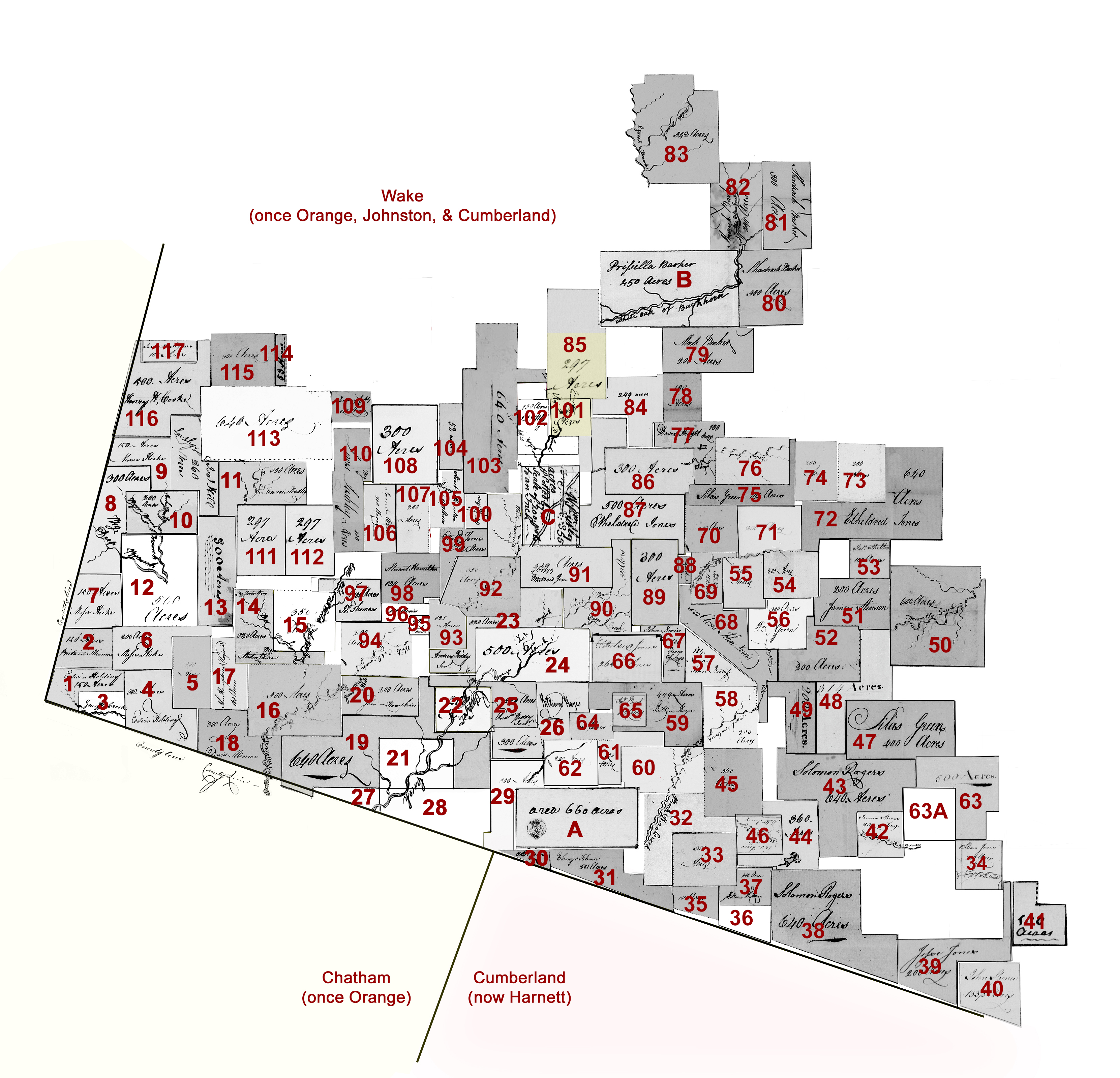
Granville District Grants issued between 1748-1763
by John Lord Carteret, second Earl Granville
To see each original document, go to nclandgrants.com and type in the county name and the corresponding State Archives of North Carolina file number.
[note: CC is an abbreviation for Chain Carrier]
- A. Richard Hill, file #48 Cumberland, issued 1 Apr 1763, being 660 acres on both sides of Buckhorn Creek CB: Robert Reivers Jones, Thomas Broom. (This land is in present-day southern Wake County indicating it was in a portion of the county originally formed from Cumberland to the south).
- B. Prissilla [Priscilla] Barker (Executrix of William Barker Deceased), file #335 Orange, issued 6 Dec 1761, being 450 acres on Buckhorn Creek. CB Tho’s Barker, Edward Hobson. Metes and bounds indicate this tract adjoined Thomas Barker’s land to the south. (This land is in present-day southern Wake County indicating it was in a portion of the county originally formed from Orange to the west.
- B+ Thomas Barker (shaded yellow), file #01136 Orange, entered 2 Sep 1761, being 700 acres on White Oak Swamp beginning on William Utley’s line. (Any file number beginning with zero indicates a grant may have been entered though for some reason it never matured and was issued. Perhaps the 700 acres incorporated or was at least adjoining the land of Priscilla Barker.
- C. William Utley, file #16 Orange, issued 21 Jan 1761, being 335 acres on White Oak Swamp. CB, Jesse Lane, Joel Lashley. (This land is in present-day southern Wake County indicating it was in a portion of the county originally formed from Orange to the west.
North Carolina Secretary of State Land Grants
[note: CC is an abbreviation for Chain Carrier]
- Edwin Holding, file 1366 Wake, issued 23 Dec 1801, being 150 acres on Tom Jack Creek joining Mimms, Hicks, and the county line. CC: Moses Hicks, Edmund Lashley.
- Britain Mimms, file 1363 Wake, issued 17 Aug 1801, being 150 acres on Shattock’s Creek joining Hicks and the county line. CC: Moses Hicks, Edmund Lashley.
- Britain Mimms, file 1362 Wake, issued 17 Aug 1801, being 100 acres joining the county line on the north side of Lick Branch. CC: Moses Hicks, Edmund Lashley.
- Edwin Holding, file 1392 Wake, issued 18 Feb 1802, being 300 acres on the waters of Tom Jack joining David Mimms and the county line. CC: Moses Hicks, Edmund Lashley.
- Moses Hicks, file 480 Wake, issued 11 Apr 1780, being 200 acres on Tom Jack Creek below Thomas Hicks’ improvement, including Moses Hicks’ improvement. CC: Joseph Thomas, Shadrack Brewer.
- Moses Hicks, file 1106 Wake, issued 18 May 1789, being 200 acres on Tom Jack Branch, joining his own and Thomas Hicks. CC: David Mimms, Hansel Hicks.
- Moses Hicks, file 1365 Wake, issued 14 Nov 1801, being 150 acres (joining Isaac Hill deceased and the county line) …survey mentions Hansel Hicks. CC: Britain Mimms, Edmund Lashley.
- Joseph Thomas [assignee of William Olive], file 886 Wake, issued 30 Sep 1785, being 300 acres on the south side of Tom Jack’s Branch joining Moses Hicks, Thomas Tedder, and the county line. CC: Thomas Tedder, William Bugg.
- Moses Hicks, file 1502 Wake, issued 19 May 1817, being 150 acres on Tom Jack joining Tedder and the county line. CC: Edmund Lashley, Willis Hicks.
- Joseph Thomas [assignee of Thomas Tedder], file 957 Wake, issued 30 Sep 1785, beginning at Thomas Hick’s corner, being 200 acres on Tom Jack Creek and crossing Bugg’s Branch. CC: Isaac Hill, William Bugg.
- Francis Bradley (assignee of John Hill), file 1047 Wake, issued 15 May 1787, being 300 acres on Thomas’ Creek joining James Oliver and Isaac Hill. CC: James Olive, Edmund Lashley.
- Thomas Hicks, file 476 [A] Wake, issued 11 Apr 1780, being 500 acres on both sides of Tom Jack Creek joining Moses Hicks. CC: Shadrack Brewer, Moses Hicks.
- Moses Hicks, file 1291 Wake, issued 10 Jun 1799, being 300 acres on Tom Jack Creek joining John Humphries “Virginia,” James Huckabee, Isaac Hill, and Martin Lane. CC: Jacob Hill and George Talley.
- Martin Lane, file 945 Wake, issued 30 Sep 1785, being 350 acres on Bear Branch joining Joseph Thomas and Levin. CC: Etheldred Jones, Silas Green.
- Joseph Thomas, file 482 Wake, issued 11 Apr 1780, being 350 acres on both sides of Little White Oak Creek and both sides of Jacob’s Creek, joining James Olive and Levin. CC: Etheldred Jones, Josiah Brown.
- Jacob Levin, file 480[A] Wake, issued 11 Apr 1780, being 300 acres on White Oak Creek above David Mimms’ entry and below Jacob’s Branch. CC: Josiah Brown, Joseph Thomas.
- John Humphries “Virginia”, file 993 Wake, issued 15 May 1787, being 160 acres on White Oak on Tom Jack Branch joining David Mimms, Moses Hicks, Martin Lane, and a “line formerly called Levins.” CC: Moses Hicks, Hansel Hicks.
- David Mimms, file 961 Wake, issued 15 May 1781, being 300 acres on the Great White Oak Creek joining the county line and Jacob Levin’s. CC: Moses Hicks, Hansel Hicks.
- Ethelred Jones [assignee of John Norris], file 934 Wake, issued 30 Sep 1785, being 640 acres on the west side of Braswell’s Creek and on both sides of White Oak Creek, joining Jacob Levin, John Humphries, Peddy’s, Daniel Oaks, Phelps Smith, Wommack’s and the county line. CC: John Sellers, John Norris.
- John Humphries “Virginia”, file 895 Wake, issued 30 Sep 1785, being 200 acres on both sides of White Oak Creek joining Jacob Levins and Josiah Brown. CC: John Norris, Garrett Stephens.
- Felps Smith, file 492 Wake, issued 11 Apr 1780, being on Cary’s Creek, where Samuel Booker now lives. CC: Daniel Oaks, Britain Womack.
- Daniel Oaks, file 244 Wake, issued 29 Mar 1780, being 200 acres “on both sides of Cary’s Creek joining the lower side of the land whereon Leonard Green Sen’r lately lived.” CC: Andree Peddy, Jeremiah Peddy.
- Andrew Peddy Senr., file 946 Wake, issued 30 Sep 1785, being 320 acres on Cary’s Creek joining his own, John Norris, Etheldred Jones, and Hamilton’s. CC: John Norris, Andrew Peddy.
- Andrew Peddy, file 288 Wake, issued 29 Mar 1780, being 500 acres on the north side of Buckhorn being the land purchased by the said Peddy of Leonard Green, including the plantation where Leonard Green Junr now lives. CC: Andrew Peddy Jur, Jeremiah Peddy.
- Andrew Peddy Junr., file 920 Wake, issued 30 Sep 1785, being 200 acres on both sides of Cary’s Creek joining Andrew Peddy Senr. and Daniel Oaks. CC: Etheldred Jones, James Sellers.
- William Hayes, file 1309 Wake, issued 10 Jun 1799, being 300 acres on Cary’s Branch joining Capt. Thomas Cary’s line. CC: Andrew Peddy, William Gaines.
- William Hayes, file 1337 Wake, issued 1 Jul 1800, being 26 acres on Buckhorn joining his own lands and the Chatham County line. CC: Mark Cook, George Nash.
- Britain Womack – From granted land in neighboring Chatham County lying in both Chatham and Wake Counties.
- Felps Smith, file 484[A], issued 11 Apr 1780, being 300 acres on both sides of Buckhorn joining Richard Hill, “including John Smith’s mill,” and joining the county line. CC: David Jones, Elkin Jones.
- William Hayes, file 1310, issued 10 Jun 1779, being 40 acres joining his own lines, James Stephens, & the land called Folsom’s land, and the county line.” CC: Thomas Peddy, ——— Norris
- Ebenezer Folsom, file 995, issued 15 May 1787, being 281 acres on the south side of Buckhorn, joining Charles Jones (formerly), Watson’s, Phelps Smith, David Jones, and the county line. CC: Joel Edwards, Frederick Jones.
- Peter Quarles, file 1054, issued 1787, both sides of Buckhorn, joining William Jones, Charles Jones, and near David Jones. CC: Joseph Thomas, James Stephens.
- David Jones, file 495, issued 1780, being 300 acres on the south side of Buckhorn joining Felps Smith. CC: Felps Smith, Elkin Jones.
- William Jones, file #975, issued 1787, being 200 acres assigned to William Jones by Daniel Oldhands. on the Fork of Neals Creek “including improvements made by Jacob Thomas.” CC: Fredrick Jones, Joshua Elkins.
- Felps Smith, file 457[A] Wake, issued 1780, being 100 acres on the Waters of Buckhorn, the warrant says on both sides of Horse Branch. CC: David Jones, Phelps Smith.
- David Jones, file 0121 Wake, being 50 acres with the “0” in the file number indicating the grant was never issued. The original warrant was for land adjoining his own and the Cumberland County line.
- William Watson, file 974 Wake, issued 1787, being 200 acres on Horse Branch, joining Phelps Smith, David Jones, and the county line. CC: John Burt, David Smith.
- Solomon Rogers, file 1470 Wake, issued 1809, being 640 acres with warrant mentioning being joined to Nathan Thomas. Survey identifies the land on Hector’s Creek joining Mathew R. Turner, the county line, and David Jones. CC: Darling Jones, James Jones.
- Jesse Jones, file 1009 Wake, issued 1787, being 200 acres on both sides of Horse Pen Prong of Niels Creek joining his own line. CC: Mark Myatt, James Lightfoot.
- John Spence, file 1293 Wake, issued 10 Jun 1799, being 133 1/3 acres joining Jesse Jones and the county line. CC: Solomon Rogers, Jesse Jones.
- William Love, file 1296 Wake, issued 1798, being 100 acres assigned to William Love by Jesse Jones. West side of Neals Creek joining Jesse Jones and William Jones. CC: John Terrialle, Clem’n Stinson.
- James Stephens, file 1393 Wake, issued 1802, being 200 acres on both sides of the Gaulberry Fork of Niels Creek. CC: Darling Jones, Redick Stinson.
- Solomon Rogers, file 1398 Wake, issued 1802, being 640 acres on the Cape Fear, the warrant mentions Nathan Thomas, William Jones, and himself. CC: Reddick Jones, William Nash.
- Solomon Rogers, file 1469 Wake, issued 1809, being 360 acres on the waters of Buckhorn, joining David Jones, his own, and William Jones. CC: Reddick Jones, William Nash.
- William Jones, file 508 Wake, issued 11 Apr 1780, being 360 acres on the south side of Buckhorn beginning at a rocky hill, joining Britain Womack and including improvements said Jones now lives on. CC: Carnaby Stephens, Elkin Jones.
- Matthew Jones [assignee of William Jones], file 1324 Wake, issued 1800, being 150 acres on Buckhorn joining William Jones and David Jones. CC: Darling Jones, James Jones.
- Silas Green [assignee of Roland Stinson], file 1035 Wake, issued 1787, being 400 acres. Head Branches of the South Prong of Middle Creek, and on both sides of Braswell’s old Road, including the Burnt Tavern, beginning at a hickory near said tavern. CC: Etheldred Jones, James Shelton.
- Nathan Thomas, file 1214 Wake, issued 1789, being 314 acres issued 1797. Joining Brasell’s Creek, his own and Silas Green lines, and David Matthews. CC: Jonathan Thomas, Asa Thomas.
- Nathan Thomas, file 509 Wake, issued 1780, being 200 acres issued 1780. Both sides of Braswell’s Creek including improvements made by Edmond Mathews. CC: John Norris, Gerrard Stephens.
- Roland Stinson, file 415 Wake. Issued 1779, being 600 acres on both sides of Braswell’s Creek, joining John Utley. CC: Gerrard Stinson, Nathan Thomas.
- James Stinson, file 1043 Wake, issued 1787, being 200 acres in the Great Branch of Middle Creek joining Rowland Stinson’s former line, Nathan Thomas, and Widow Jones. CC: Silas Green, John Utley.
- Nathan Thomas, file 509 Wake, issued 1780, being 200 acres in both sides of Brasswell’s Creek including improvements by Edmond Matthews. CC: John Norris, Gerrard Stevens.
- James Stinson, file 1020 Wake, issued 15 May 1787, being 100 acres on the west side of Braswell’s Creek and on both sides of Little Lick Branch, joining Rowland Stinson. CC: Christ’r Osburn, Silas Green.
- Charlie Jones, file 458 Wake, issued 1780, being 200 acres on the Holley Branch joining Sampson Holland and Richard Green, including improvement whereon Jones now lives. CC: Nathan Thomas, John Norris.
- Richard Green, file 496 Wake, issued 1780, being 200 acres on the south side of Holly Spring, joining Charles Jones, Sampson Wood and including said Green’s two improvements. CC: Gerrard Stevens, Nathan Thomas.
- William Green [assignee of John Jones], file 976 Wake, issued 1787, being 300 acres on the west side of Buckhorn at the old Ridge Path joining Nathan Thomas and Widow Jones. CC: Silas Green, Britain Utley.
- John Norris, file 1345 Wake, issued 1800, being 184 acres on Cary’s Creek joining his own and Matthew’s line. CC: Peyton Norris, Andrew Peddy.
- John Matthews, file 481[A] Wake, issued 1780, being 200 acres on both sides of Buckhorn Creek joining William Jones. CC: Carnaby Stephens, Elkin Jones.
- William Hayes, file 1346 Wake, issued 1780, being 449 acres on Buckhorn and Jim’s Branch joining John Burt, William Jones, Etheldred Jones, John Norris , Andrew Peddy, and his own line. CC: Peyton Norris, Andrew Peddy.
- Francis Hobson, file 453 Wake, issued 1780, being 350 acres joining Brittain Wamock, William Jones, and William Watson. CC: Carnaby Stevens, Elkin Jones.
- William Watson, file 456 Wake, issued 1780, being 150 acres on the north side of Buckhorn joining Joseph Cobb, Francis Hobson, Elkin Jones, and his own line. CC: David Jones Elkin Jones.
- Joseph Cobb, file 466[A] Wake, issued 1780, being 200 acres in the fork of James’ Branch and Buckhorn, joining the lands of James Stephens and Felps Smith. CC: Felps Smith, David Jones.
- Silas Green, file 1230 Wake, issued 20 Jun 1797, being 500 acres on Niels Creek and Braswell’s Creek joining his own line James Stinson, “Croswell’s old field,” “Hilliard Thomas’ line,” William Jones’ line, and the head of Horse Pen Branch. CC: Thomas Beany, Jas Stinson.
- 63 1/2 Hilliard [Hillery] Thomas, no record for this tract though Silas Green’s adjoining 500 acres key map 63 identifies the land as belonging to Hilliard Thomas. The 1790 census further identifies Hillery as a free person of color. Hillery is believed to have moved or once lived in neigboring Franklin County to the north.
- Elkin Jones, file 457 Wake, issued 1780, being 100 acres on both sides of James Branch of Buckhorn. CC: David Jones, Phelps Smith.
- John Burt [assignee of John Elkin], file 982 Wake, issued 1787, being 100 acres on both sides of James’ Branch joining his own and Peter Qualls’. CC: David Jones, Thomas Hayes.
- Etheldred Jones, file 1327 Wake, issued 18 Jun 1800, being 265 acres on Carys Creek joining Andrew Peddy. CC: John Norris, Andrew Peddy.
- John Norris, file 1275 Wake, issued 1799, being 150 acres on Cary’s Creek joining Peddy, Hayes, and his own line. CC: Andrew Peddy, William Gaines.
- John Norris, file 986 Wake, issued 1787, being 500 acres on Buckhorn, the head of Holly Spring Branch joining the Ridge Path, an entry of Charles Jones, Green’s line, Wm. Jones, and his own line. CC: Etheldred Jones, Britain Utley.
- John Norris, file 1044 Wake, issued 1787, being 150 acres on Holly Spring Branch joining Richard Green, Sampson Wood, and Etheldred Jones. CC: Etheldred Jones, Britain Utley.
- Etheldred Jones, file 416, Wake, issued 1780, being 200 acres joining Sampson Wood. CC: John Norris, Josiah Brown.
- Sampson Wood, file 510 Wake, issued —-, being 200 acres on the south side of Utley Creek (Holley’s Spring Branch) joining said Sampson Holland’s line near the head including Holland’s improvement. CC: Lewis Jones, Burwell Pope.
- Etheldred Jones [assignee of Burwell Pope], file 1006 Wake, issued 1787, being 640 acres joining the lines of Charles Jones, Junr., Sampson Wood, Sampson Holland, and Christopher Osborn on White Oak and Braswell Creeks. CC: Silas Green, James Shelton.
- Christopher Osborn, file 478[A] Wake, issued 1780, being 200 acres on the ridge between Utley’s and Braswell’s Creek. CC: Burwell Pope, Lewis Jones.
- Sampson Holland [Wood], file 456[A] Wake, issued 1780, being 200 acres on the head of Utley Creek, on the north side of Holons Spring Branch joining Christopher Osborn. CC: Etheldred jones, Christopher Osborne.
- Silas Green [assignee of Martin Lane, who was assignee of Burwell Pope], file 1032 Wake, issued 1787, being 144 acres on Holland’s Mill Creek joining James Holland, Sampson Wood. CC: Britain Utley, Christopher Osborne.
- James Holland Sr., file 421 Wake, issued 1780, being 250 acres on both sides of Utley Creek joining Henry Kent’s line. CC: Edmund Lashley, Thomas Holland.
- David Straight [assignee of Thomas Holland], file 1080 Wake, issued 1789, being 150 acres on both sides of Utley Creek, joining Sampson Holland and James Holland. CC: Thomas Holland, John Norris.
- Mark Barker, file 1301 Wake, issued 1799, being 100 acres on the Great Branch of Big White Oak Creek joining his own and Straight’s. CC: Shadrack Barker, Lewis Barker.
- Mark Barker, file 1027 Wake, issued 1787, being 200 acres on the south side of White Oak joining the widow Letman’s south line. CC: Shadrack Barker, Lewis Barker.
- Shadrack Barker, file 998 Wake, issued 1787, being 300 acres on both sides of Little Creek joining his line and widow Letman. CC: Mark Barker, Lewis Barker.
- Shadrack Barker, file 1026 Wake, issued 1787, being 300 acres joining his former entry (a grant which Jesse Barker entered a Caveat). CC: Mark Barker, Lewis Barker.
- Shadrack Barker, file 1025 Wake, issued 1787, being 300 acres on both sides of White Oak joining the lands of widow Letman and Benjamin Black including his own improvement. CC: Mark Barker, Lewis Barker.
- William Barker, file 498[A] Wake, issued 1780. Being 342 acres on the Great Branch of White Oak on both sides of the Middle Creek joining Joseph Lane, Benjamin Blake, Burwll Pope. CC: Lewis Barker, Shadrack Barker.
- William Bridges, file 1352 Wake, issued 9 Oct 1800, being 249 acres on the Big White Oak joining Britain Utley, William Barker, Mark Barker, and his own land. CC: Britain Utley, David Edwards
- William Barker, file 388 Wake, issued 1 Apr 1780, being 297 acres on both sides of White Oak joining sd Barker’s lines, including his improvements being one half of a survey of land formerly made by Thomas Barker. CC: Mark Barker, Drury Barker.
- Henry Kent, file 218 Wake, issued 1 Apr 1780, being 300 acres on both sides of Utley’s Creek above Utley’s including Kent’s improvement. CC: Sampson Holland, Britain Utley.
- Etheldred Jones [assignee of James Hinton], file 963 Wake, issued 15 May 1779, being 500 acres on the waters of Cary’s Creek and Utley’s Creek joining Rich Green and Henry Kent, Straight, Utley. CC: John Norris, John Utley.
- William Stewart, file 1403 Wake, issued 17 Sep 1802, being 33 acres on Cary’s Creek joining John Norris. CC: John Norris, Needham Norris.
- Richard Green, file 243 Wake, issued 29 Mar 1780, being 300 acres on Carey’s Creek near the old spring branch. CC: Henry Kent, Britain Utley
- John Norris, file 851 Wake, issued 30 Sep 1785, being 300 acres on both sides of Cary’s Creek joining Andrew Peddy, Etheldred Jones, and Richard Green. CC: Garret Stephens, Andrew Peddy Junr.
- Etheldred Jones, file 434 Wake, issued 11 Apr 1780, being 449 acres on both sides of White Oak Creek joining John Utley including the improvement the said Jones bought of Leonard Green, Senr. CC: Josiah Brown, Joseph Thomas
- Etheldred Jones, file 429 Wake, issued 12 Apr 1780. Being 350 acres on both sides of White Oak including the improvement formerly purchased of Christopher Osborne (Little). CC: Josiah Brown, Joseph Thomas.
- Hamilton Stewart, file 498 Wake, issued 11 Apr 1780, being 125 acres joining Etheldred Jones and Joseph Thomas including said Hamilton’s improvement. CC: Josiah Brown, Joseph Thomas.
- Josiah Brown, file 470 Wake, issued 11 Apr 1780, being 200 acres on both sides of White Oak joining a claim made by Joseph Thomas and another by Jacob Levin. CC: Etheldred Jones, John Norris.
- Josiah Brown, file 908 Wake, issued 30 Sep 1783, being 66 acres on White Oak joining his own line, Jacob Leven’s, and John Humphries’ (Virginia). CC: Etheldred Jones, Andrew Peddy.
- Josiah Brown, file 907 Wake, issued 30 Sep 1783, being 100 acres on Great white Oak joining Stewart Hamilton, Joseph Thomas, and his own line. CC: John, Norris, Andrew Peddy.
- Joseph Thomas, file 939 Wake, issued 11 Jul 1783, being 100 acres on both sides of Little White Oak Creek near a road, joining his own and James Olive and his own line. CC: Andrew Peddy, Stuart Hamilton.
- Stuart Hamilton, file 1039 Wake, issued 15 May 1787, being 134 acres on the Great White Oak joining his own, Etheldred Jones, and Josiah Brown. CC: Andrew Peddy, Garret Stephens.
- Etheldred Jones, file 1227 Wake, issued 25 June 1797, being 125 acres between the two White Oak Creeks joining Stewart Hamilton and his own lines. CC: James Huckabee, Andrew Peddy.
- Etheldred Jones [assignee of Mark Sugg], file 1245 Wake, issued 5 Apr 1798, being 65 acres on the head of Reedy Branch joining his own, John Rie and Joshua Sugg …on west side of Great White Oak beginning at corner of his Bet Day tract.: CC: James Huckabee, Andrew Peddy.
- John Utley, file 219 Wake, issued 1 Apr 1780, being 300 acres on both sides of Great White Oak Creek, “being one half of a survey of land formerly made by Thomas Barker and also the vacant land joining the sd. survey.” CC: Sampson Holland, John Norris.
- John Utley, file 848 Wake, issued 27 Sep 1779, being 150 acres on both sides of Great White Oak Creek joining his own line and William Barker. From the survey, Lashley Branch enters Great White Creek northeast of this tract and running through the southwest corner of the tract is “Thomas Barker Branch.” CC: Mark Barker, Drury Barker.
- William Barker, file 1222 Wake, issued 17 Oct 1796, being 640 acres joining Jno. Utley. Drury Barker, and Etheldred Jones and his own. CC: Mark Barker, William Barker Junr.
- Lewis Lashley Senr., file 1471 Wake, issued 11 Sep 1812, being 52 acres on Little White Oak Creek, joining William Barker and his own lines CC: William Barker Junr.
- Stuart Hamilton, file 1308 Wake, issued 10 June 1799, being 150 acres joining Etheldred Jones, James Olive, and William Barker on the waters of Big White Oak and Little White Oak. CC: James Huckabee, Andrew Peddy.
- James Olive, file 1057 Wake, issued 15 May 1787, being 200 acres on Little White Oak joining Lewis Lashley. CC: Edmund Lashley, Joshua Denby.
- James Olive, file 452[A] Wake, issued 11 Apr 1780, being 200 acres joining his own line on the west. CC: John Hill, Anthony Olive.
- Lewis Lashley, file 340 Wake, issued 1 Apr 1780, being 300 acres above an entry by James Olive Jun including the improvement whereon the said Lashley lives. CC: John Utley, Sampson Holland.
- Edmund Lashley, file 1297 Wake, issued 10 Jun 1789, being 53 acres on Little White Oak Creek, joining Lewis Lashley and Jacob Hill. CC: Josiah Segret, Abel Olive.
- Lewis Lashley, file 1060 Wake, issued 15 May 1787, being 400 acres joining his own and James Olive, Holland. CC: James Olive, Edmund Lashley.
- James Olive Junr., file 402 Wake, issued 1 Apr 1780, being 297 acres including improvement whereon said Olive lives. CC: John Hill, Joshua Denby.
- James Olive Junr., file 339 Wake, issued 1 Apr 1780, being 297 acres on both sides of Thomas’ Creek of White Oak. CC: John Hill, Joshua Denby.
- Isaac Hill, file 491[A] Wake, issued 11 Apr 1780, being 640 acres on the north side of White Oak on both sides of Thomas’ branch joining Lewis Lashley. CC: John Hill, Anthony Holland.
- Edmund Lashley, file 1297 Wake, issued 10 Jun 1799. Being 53 acres on Little White Oak Creek joining Lewis Lashley Jr. and Jacob Hill, including his own improvement. CC: Josiah Segret, Abel Olive.
- Isaac Hill, file 309 Wake, issued 11 Apr 1780, being 300 acres on Thomas Branch joining his own line, Anthony Holland, and Lewis Lashley. CC: Anthony Olive, Lance Fox.
- Henry H. Cook, file 1376 Wake, issued 3 Jun 1801, being 500 acres on the waters of Little Beaver and Tom Jack Creeks joining Josiah Segrest [Seger’s], James Huckabee, and Moses Hicks. CC: Edmund Lashley, Willis Hicks.
- Josiah Segcore [assignee of Joshua Denbey], file 1332 Wake, issued 10 Jul 1800, being 100 acres on Beaver Creek joining John Dockery, William Suggs, and Olive. CC: Frederick Taylor, Thomas Womble.

This is great! My Rainey ancestors were in Orange County, by 1735. My branch of the Rainey’s arrived in Tennessee, having left Orange County in about 1843. The Utley’s of Wake County married into my mother’s (Rainey) side, and some of them also wound up in West Tennessee. Whenever I have run into an Utley in west Tennessee, yep, it’s one of them! Thanks, George. Oh, I just found a tree belonging to Norma Guthrie, and she has the Utley’s in my tree, and Brittain and John Utley.
Great work, George! Ken
Thanks cousin and my next post will be mostly in western TN ….Hickman, Bennett and then in Logan KY with mentions of Utley, Peddy, and Barker.