Mistakes made in compiling family histories have repercussions far from the implications of misunderstood documentation such genealogies are built upon. For instance, every online report I have seen on the family of Gideon Green of Anson County, North Carolina, indicates him to be rooted in James Green Jr, of early Bath County, North Carolina. Not so! Gideon of Anson clearly appears in a 1772 Wake County civil action paper alongside Joseph Thomas and people close to a person there named Leonard Green –who happened to settle in the county from earlier in Edgecombe. Probably the father of Gideon Green, Leonard is the son of Richard Green, who passed from Chowan County through Bertie before moving beyond Edgecombe County. The ancestry of Gideon Green does not go back to James, as is colorfully told in error by many.
Looking at just one responsible site, Ancestry.com, nearly 1300 public trees base their genealogies on Gideon wrongly being assessed to be the son of James Green. There are other such sites, including WikiTree, FindaGrave, and FamilySearch. Mistakes are a part of life, but as I have always heard, a mistake is measured by how far back down the dirt road you have to walk to find the tool to fix it, but Wow! –this colossal number makes me laugh –and cry. I remain curious concerning Ancestry.com’s corporate take on how best to handle the spreading of such egregious errors. Do they even care? Thankfully, this writing does not delve into that sort of issue but instead into a simple and common surveyor’s mistake, which I discovered while tracing lands once owned by the family of Gideon Green. I am a retired educator; sorry, much of who I am grows from my love of teaching others. Let’s dig into the Green family lands situated along the Rocky River in old Anson County, now Union County.
_______________________
On Aug 6, 1817, Anson County surveyor John Hough walked the land along the Rocky River and surveyed state grant 6318[A], which would be issued to Jesse Green on Nov 27, 1817. At that time, this son of deceased Gideon and his widow Elizabeth Green, Jesse Green received 200 acres on Rocky River “joining Elizabeth Green’s mill tract.” Note that the grant file number is suffixed with a bracketed letter [A]. The additional letter is used occasionally for clarity’s sake because the file number has been otherwise proven not to be distinct. Furthermore, the surveyor must have been confused as he titled the grant “Lenard Green,” which he struck through before correcting the name to be “Jesse Green.” See below:
 More important is a mistake involving the platting process and how the surveyor interpreted his numbers. Before moving forward, I must ensure the reader understands the process of platting land.
 Based on an original compass reading at a given landmark or starting point, a survey plat is comprised of lines chasing one another from tail to head. Land boundaries are defined legally by a series of written descriptions representing hand-drawn boundary lines. Each line description includes two landmarks (tree, rock, or maybe the corner of another person’s land) that mark starting and endpoints. Descriptions also include distance defined by units of the measuring device used in the survey: a pole which equals 16 ½ feet or a chain which equals four poles. Lastly, the surveyor accounts for direction based on degrees east or west from either north or south. To explain this, let’s look at the compass to the right.
For example, look at the red line running northeast. Typically referencing degrees from the North-South axis, if this were a survey line, it would run 50 degrees East of due North. Considering another example, the blue line pointing to the southwest runs 33 degrees West of due South. This type of information appearing in surveys also includes a measured distance for which this scenario uses 64 poles. Thus, the nomenclature used in survey descriptions typically begins with a starting landmark, such as a red oak (in this example), followed by the abbreviated direction and distance. Finally, descriptions include a stopping landmark such as a dogwood among three pines (in this example). Standing at the stopping point, a compass reading would be made for the new line before that line is measured using either the chain or pole. The terminology is called “metes and bounds,” with the landmarks being the metes (where lines come together) and the bounds being the actual line or vector running some defined direction based on an initial compass reading. As for our red and blue lines above, the metes and bounds may appear in a survey description as follows (if the distance were again 64 poles and the metes were trees as stated).
For the red line:
Beginning at a red oak, runs North 50 degrees East 64 poles to a dogwood among three pines.
For the blue line:
Beginning at a red oak, runs South 33 West 64 poles to a dogwood among three pines.
And for the actual plat or visual representation of the land survey, nomenclature for the above would read:
(Red) North 50 East 64 (Blue) South 33 West 64
Hopefully, you have followed thus far, and to test your understanding, let’s look again at the 1817 survey for Jesse Green’s 200 acres, as is shown above. Note from the survey that the first line (running from the rectangular inside corner) runs north 36 chains. See it? Also, note that the North-South axis is oriented horizontally. The next line runs a short distance along the river before heading due South 66 chains. At that point, a line runs South 60 West 40 chains. Does anything look wrong with that line? Taking a quick look at the compass and thinking about what 60 degrees west of due south should look like, the survey plat above appears to be different …in error. The angle drawn on the plat is closer to 30 degrees, while the description says it should be 60 degrees. I believe the surveyor’s mind was oriented vertically on the paper while the plat was instead oriented horizontally.
My belief is confirmed as the next line is defined as South 5 West 18 chains. A nomenclature typically not used, John Hough oriented the line five degrees south of the horizontal or East-West line instead of basing the line off of the North-South line. If following the standard customarily used, the metes and bounds should instead read South 85 West 18 chains.
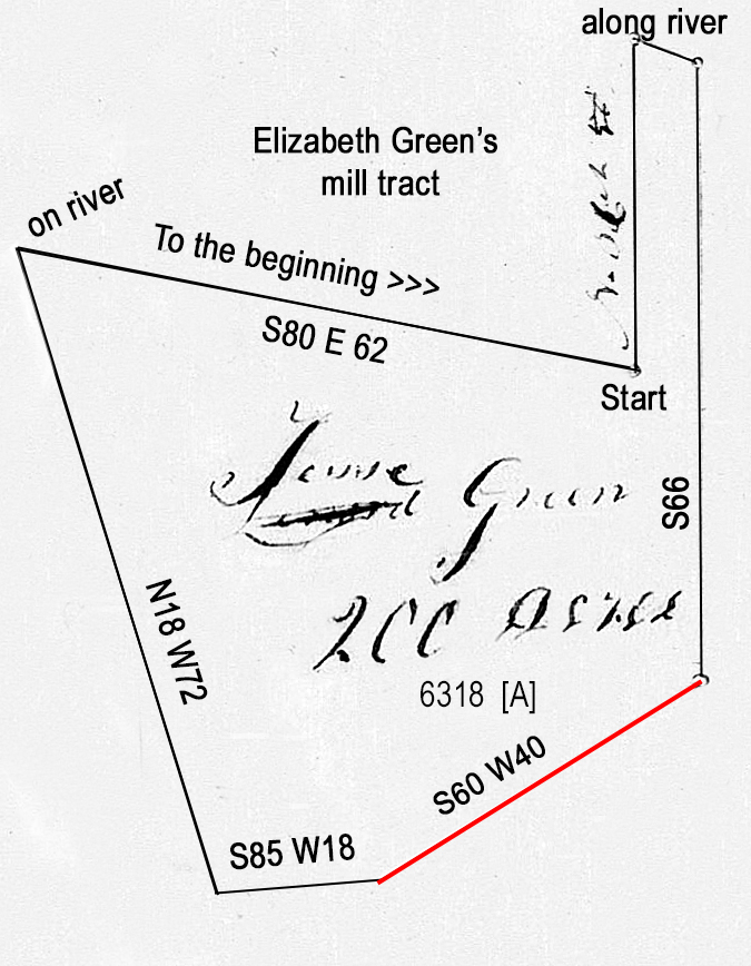 If the above survey is redrawn properly oriented, the resulting plat looks different. Note to the right how the corrected line (red) runs in a more horizontal direction and how that results in the lifting of the northwest corner. What was first seen as a rectangular starting point is now an acute angle. Also, note that the adjoining land on the river is described as “Elizabeth Green’s mill tract.”
I now have enough information to incorporate additional sleuthing skills. Most importantly, I can look at adjoining tracts to see if metes and bounds properly relate to my changes to the 1817 survey.
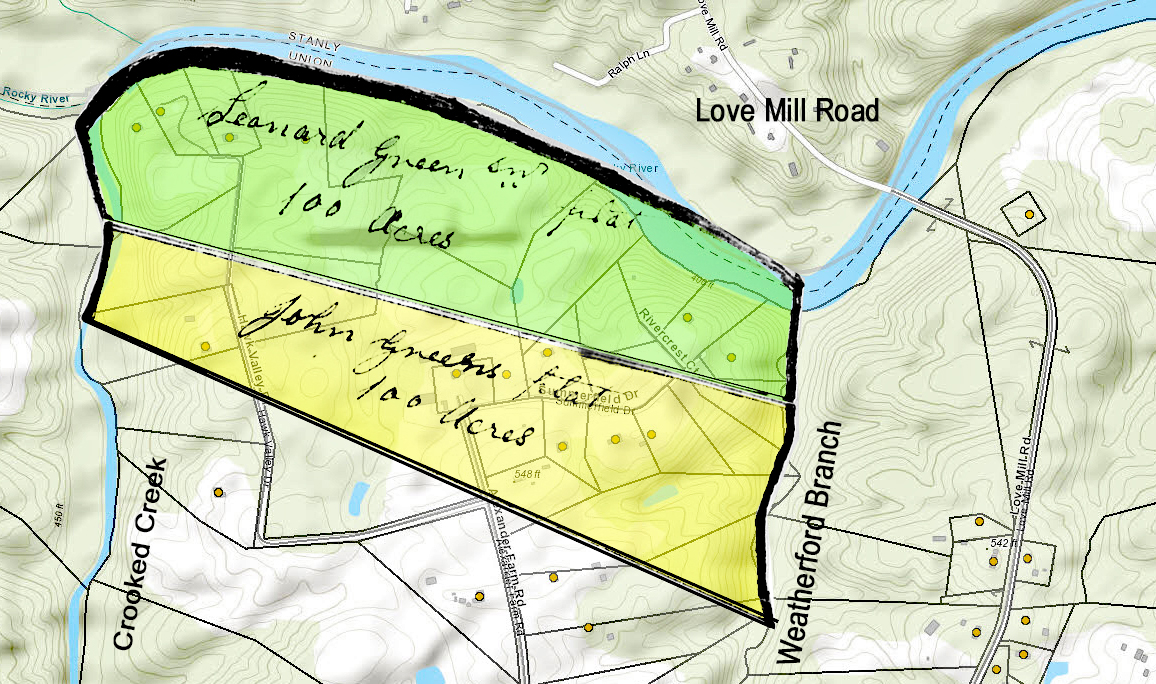
From the present-day Union County GIS map, Jesse Green’s 1817 grant plat is locatable below within the myriad of lines near and downstream of Love Mill Road, where the land’s old boundaries correspond somewhat with today’s property lines. However, much time has passed, and today’s property lines must not be seen as perfectly accurate concerning the old plat though they can be very helpful in narrowing down the search for where people once lived and worked.

Using Google to zoom further on an aerial view of the site, tree lines, and other landmarks related to the lay of the land can be used in one’s search. In this case, Elizabeth Green’s mill tract is located in a bend where I can imagine the family damming the water within a narrow passing between an island and the bank of the river. Drilling even deeper into the image (below), one may imagine the exact location of an old mill dam and where best to look for remnants of it today. And for those interested, note that the nearby road is called Love Mill Road because Charles C. Love once operated yet another mill situated a short distance west of the bridge on the Stanly County side of the river.

Beyond identifying Jesse Green’s granted land and the mill tract once owned by his mother, Elizabeth, the location above allows me to begin putting back together some of the adjoining ownership. Though the following may not be perfectly accurate, I believe it should be useful in understanding the early Green family and their start in Anson County. Looking at the image below, Weatherford Branch enters Rocky River on the extreme western edge of the map while Grassy Creek can be seen entering the river to the east. See them? Shaded pink, Peter May received a grant of land east of Weatherford along the present-day Love Mill Road. Notice how nicely that piece of land mates to Jesse Green’s yellow shaded tract. And joining Jesse’s land on the long North-South line to the east, his mother Elizabeth received the red shaded tract. And east of that land is Elizabeth Green’s grant for land which roughly reflects the big bend in Rocky River.

Of interest and remembering me writing about how errors live long after their incidence? –let’s take a deeper look at Nathan Green’s land. Shaded blue, that tract joins Jesse Green’s land and the questionable line that I believe was measured correctly, though drawn on plat incorrectly. Note that Nathan’s grant survey calls out a line as South 60 West 40 chains, which reflects the corrected angle. The land’s southeastern line is also defined in the grant as running along Grassy Creek. That fact is important in allowing me to position the land.
However, for some reason, Nathan’s blue shaded tract calls out the line joining Elizabeth’s red tract as North 70 West 33.5 chains. As for Elizabeth’s red shaded tract, the same line is called out as North 70 East 33.5 chains. Somehow influenced by the previously noted error, the length and degree of the lines are the same though one is said to run northeast while the other southeast. A simple mistake, I wonder about impact and how the remaining line on Nathan’s tract should be interpreted. The answer will be known upon my learning how the adjoining owners called out their land holdings. Ugh ….but for now let’s no go any further with that matter. Instead, while in the neighborhood, let’s take a look at other lands owned by the Green family.
Looking upstream, beyond Elizabeth’ Green’s land and beyond Love Mill Road, the first stream entering Rocky River is Weatherford’s Branch. And beyond Weatherford’s is the mouth of Crooked Creek which rises in nearby Mecklenburg County. Spanning the two streams along the river are two adjoining tracts issued to John and Leonard Green (see below). That land later passed through Peter Hagler who I believe operated a mill on the land, maybe originating with the Green family.
Now looking downstream in the opposite direction, remember Nathan and his mother Elizabeth Green’s land ended in the vicinity of Grassy Creek as has already been shown. Bordering Grassy Creek, Leonard Green, son of Gideon and Elizabeth received a grant for land along the river (reddish brown). To the east of that land, John Culpepper deeded land to Jacob Green in 1778 (pink). Note that this Jacob is a brother or other relation to Gideon as his son of same name was born later. So, here we have members of the earlier family acquiring land very close to each other. Later acquisitions in the area include two more tracts by Jacob Green, though I’ve not yet established the relationship (blue and green). In the middle of it all is Jonathan Austin’s grant who later acquired Leonard Green’s River tract.

There are other pieces of land which I have yet to resolve. For now, the following gives a glimpse at additional Green family lands west of Grassy Branch. More later…

