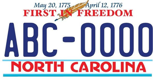
Often seen passing Hwy 24-27 near places like Locust, Red Cross, and Endy, our state’s most-prized license plate celebrates April 12, 1776, a time when the signing of the Declaration of Independence was drawing near. So, what’s so special about the date, and on what basis does our state claim to be first? And what does that have to do with Stanly County? The answer lies in the Fourth Provincial Congress, when North Carolina’s assembly authorized three delegates to attend the Continental Congress to vote for independence.
Meeting in Halifax, in the northeastern part of our state, the assembly set forth its position in a document we know today as the Halifax Resolves. “Taking into consideration the usurpations and violences attempted and committed by the King and Parliament of Britain against America,” the paper details the British subjugation. In defining a foundation for North Carolina’s position on matters, the chosen delegates to the Continental Congress were armed with the position statement, which guided their representation at the meeting. We were indeed first! The Halifax Resolves richly tell of our state’s beliefs, along with the vision for moving forward:
Resolved that the delegates for this Colony in the Continental Congress be impowered to concur with the other delegates of the other Colonies in declaring Independency, and forming foreign Alliances, resolving to this Colony the Sole, and Exclusive right of forming a Constitution and Laws for this Colony, and of appointing delegates from time to time (under the direction of a general Representation thereof to meet the delegates of the other Colonies for such purposes as shall be hereafter pointed out.
But who were these men, and what is the connection to Hwy 24-27? Stanly County was not even a dream back then as it was merely a remote section of the much larger Anson County. Daniel Love, Samuel Spencer, John Crawford, James Pickett, and John Childs were chosen to represent Anson County at the meeting in Halifax. All these men owned significant properties, and did you know that the landscape of present-day Stanly County was once dotted with plantations owned by such rich and powerful people?
Our quilted landscape reveals things that elude most people today. Moving from the east, people period families set their sights beyond the Yadkin, with settlement beginning in the 1740s and accelerating rapidly in the 1760s and 70s, likely driven by rumors and curios notions concerning what may lie beyond. Some made the move physically though others may have dreamed of managing their western plantations safely from their homes in the east. New opportunities arose in the troubled back country. Deeply entrenched, the remoteness, dysfunctional government, and scheming and private-side land speculation all played a role on who we became. Our start may be much different from what many believe.
Some who bought land in the new territory lived on it and fought for …or against independence. We were both Patriots and Tories. Sometimes overlooked, many crossed the river and acquired land in today’s Stanly County either before the war or after as they passed through this place on their walk west. There were also politically significant and immensely wealthy people whose influence and desire to own plantations in the West provided the impetus for many poor dreamers to follow suit. It was not time for settling down, but one moving forward, and it amazes me how much of today’s Stanly County was physically claimed early in time, if only held briefly. Many who lived here could be found in South Carolina, Georgia, Tennessee, or elsewhere by 1800. And in all that cultural motion lies the untold foundation of who we were and gives us a starting point un understanding how we evolved from our days as revolutionaries.
In my car and crossing Big Bear Creek on Hwy 24-27, I can’t help but smile at the sighting of a pick-up truck plated with tags reading “First in Freedom.” I bet the driver isn’t aware that the land he passed to the south was once owned in part by James Pickett, a man who happened to be our early county’s representative on that important day in April 1776. I cannot help but feel a moment of pride as I read the words written on a flashy piece of tin hanging from this man’s rear bumper. But even for myself, this is a new realization, one born in the ah-ha moments of studying land records. Let’s delve deeper into James Pickett.
_______________________________________
James Pickett, who represented Anson County at North Carolina’s Fourth Provincial Congress, joined with William Coleman to acquire numerous colonial land grants, of which three are relevant to Stanly County. Likely as speculative investments and not the places they chose to live, the patented lands belonging to these men were located at the Narrows on the Yadkin River, and on both Long and Bear Creeks. Let’s delve into the latter two, as that’s as far as I have studied in my mapping project. Starting first with 200 acres patented on Bear Creek in 1774. As shown below, the survey starting point is located “about three hundred yards from the said creek, below Charles Harrington’s improvement.” Remember, this was 1774, a time before many of our families crossed the Yadkin.
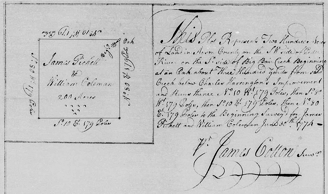
James Picket and William Coleman,
file # 3553 Anson NC, entered 21 May 1773, issued 23 Jul 1774, 200 acres.
This plot represents two hundred acres of land in Anson County on the S W side of the Pee Dee River on the So. Side of Big Bear Creek beginning at an oak about three hundred yards
from said creek below Charles Harrington’s Improvement and runs thence No. 10 Wt 179 poles, then So 80 Wt 179 poles, then So 10 Et 179 poles, then No 80 Et 179 poles to the beginning surveyed for James Pickett an d William Coleman June 30th 1774. James Cotton, Surv’r
No deed or grant survives for Charles Harrington within the vicinity; however, Charles’ brother Whitmell did receive two patents for land no more than a mile or so down Big Bear Creek in today’s Booger Hollow, and a surviving Montgomery County deed tells the story of Whitmell’s tie to the Bankston and Adaire families and a migration leading from the creek in the 1790s. Additionally, deeds do mention lands owned by Charles Harrington. And of special interest, the Pickett and Coleman tract adjoins and is located below today’s Hwy 24/27, taking in or bumping against an important intersection, being the old Bankston Road (today’s Hwy 24/27) and the Concord Road which is also called Paul’s Road.
The Pickett and Coleman patent passed down to a person named James Henly, who, in 1822, conveyed the property jointly to Benjamin Cagle and George Whitley. The deed refers to an unspecified amount of land, being the 200 acres on Bear Creek “surveyed for Pickett and Coleman except for a small parcel which George Whitley Jr’s line intersects.” The land was “equally divided between the said Cagle and Whitley, the line is to be run a direct course from the creek to the back line so as to divide the said tract equally, the lower part of s’d tract to belong to Cagle and the upper to Whitley. The description does not call out every mete and bound; however, one of the survey lines, running “South 10 East 179 poles,” reflects the original patent issued to Pickett and Coleman.
As for the Long Creek land grant, the two men acquired an even larger tract of 300 acres located half of a mile downstream, below “Green’s Improvement.” I believe this notation must represent Richard Green, or possibly family member Leonard Green who had spread west from Edgecombe County through Wake before travelling further west to cross the Yadkin River. Note that Richard Green acquired land grants to the north, on Long Creek and Little Creek of Little Bear Creek.
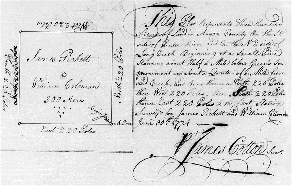
James Pickett and William Coleman,
file # 3557 Anson NC, entered 21 May 1773, issued July 5th, 1774, 300 acres.
This plot represents three hundred acres of land in Anson County on the S. W. side of Pee Dee River and on the N. E. side of Long Creek. Beginning at a small pine standing about half a mile below Green’s Improvement and about a Quarter of a Mile from the said creek, and runs thence North 220 poles then west 220 poles then south 220 poles thence East 220 poles to the first station. Surveyed for James Pickett and William Coleman June 30th, 1774
James Cotton, Surv’r
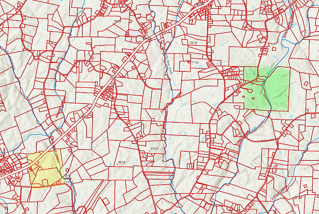
I’m amazed that these properties, acquired well before the American Revolution, can easily be spotted on today’s Stanly County GIS map. On the map below, note that the yellow shaded tract crossing between the Frog Pond Crossroads and Big Bear Creek was once the 200 acres owned by James Pickett and William Coleman. I could tell much more about that significance, but for this post, glance a bit further east to the green shaded tract that crosses Long Creek. Wow, can you see how perfectly the old marks have survived to tell this story today? And concerning the green tract, that property passed somehow to Thomas Louder, (Lowder) who gift-deeded the southeast portion to Amy Cagle, his daughter and wife of Benjamin Cagle. The remainder of the property was likewise gift-deeded to his daughter Caty Poplin, wife of Jesse Poplin. Area deeds for people like James Coley, John A Woody, Solomon Hathcock, and JI Luther and J S Efird mention adjoining property lines against the lands of Caty or Catherine. And ta bit to the north and east, it so happens one large tract was acquired by the father of Tennessee’s Governor during the American Civil War while nearby property belonged to a fellow who was promoted to rank of Brigadier General in charge of all of North Carolina’s military immediately following the American Revolution. It should be celebrated that lands beyond the Yadkin were, at one time, ripe for speculation in ways we hardly recognize. Please stay in touch as much more about this reality will be shared in coming months