Most of us rooted in southwest Stanly County are aware of the genealogies of Drury Morgan and his neighbor William Brooks. There are also others such as William Gurley and John Austin who may have tipped their hats at one another from their fields across the river. But what was life genuinely like for these men who we hold as being among the first to settle the Rocky River? In answering this question, an eager genealogy enthusiast might find satisfaction in mapping a path through the status quo, being little more than a regurgitation of genealogies frequently plastered across the internet. There are also cousins who dig more deeply to reveal layers of family stories hidden within fragmented legal documents. Searching hard to build new narratives does not guarantee some deep and provable understanding will be found. Instead, though the effort may reveal new possibilities, new finds ultimately plateau leading to new questions we may never answer. Of this sort of thing, I enjoy looking deeply and I hope you realize that the information offered here didn’t happen without struggle. Here are some bits and pieces I hope will help you in your exploration to learn more about your family.
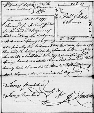
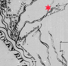
In Dec 1779, Goin Morgan made entry of 250 acres “lying on Rocky River. The survey reads: “beginning below the fish trap: below the mouth of Island Creek including Benjamin Bowlings improvement” (see A). There’s a problem with this 1700s legal description as it can be proven that the land is actually located downstream from Rockhole Creek and therefore is situated upstream from Island Creek, not below it. And beyond anything related to the Morgan family and their neighbors, who was this person named Benjamin Bowlings? I cannot help but think he is somehow related to a fellow of same name whose descendants struggle online to understand his movement through our North Carolina Piedmont. I would love to hear from anyone descending from this Benjamin Bowling [Bolling].

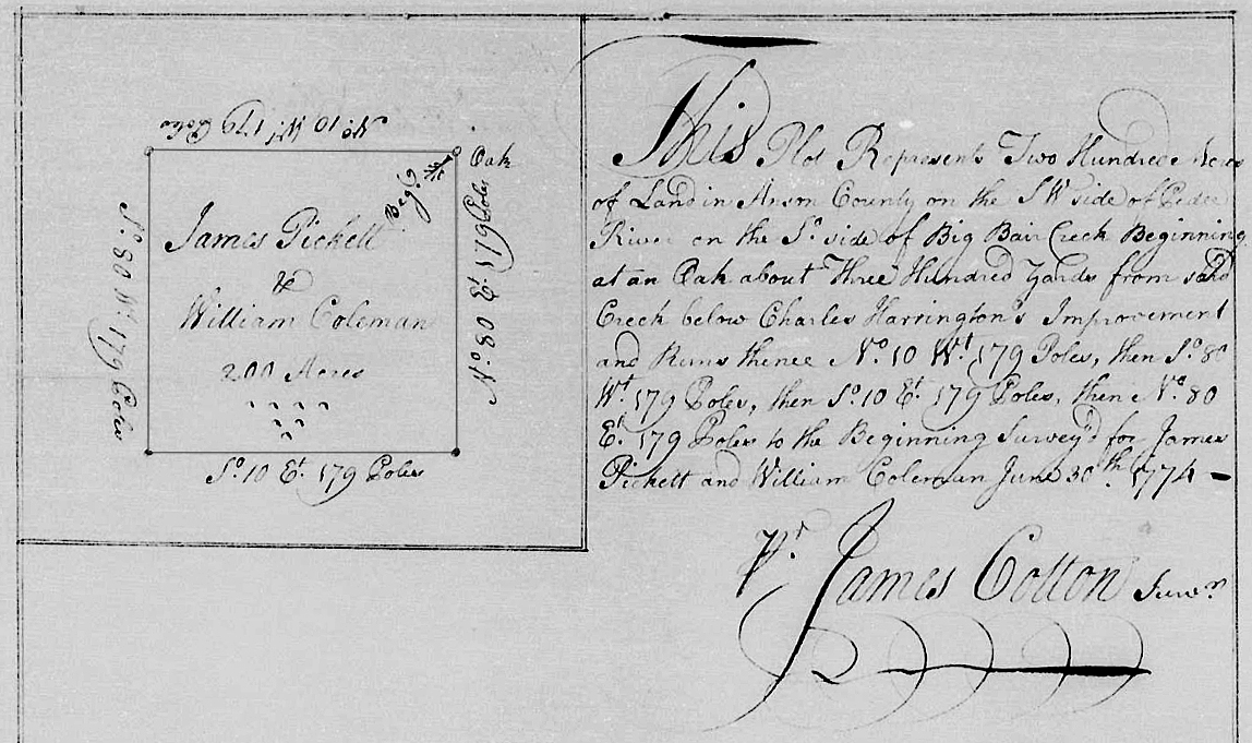
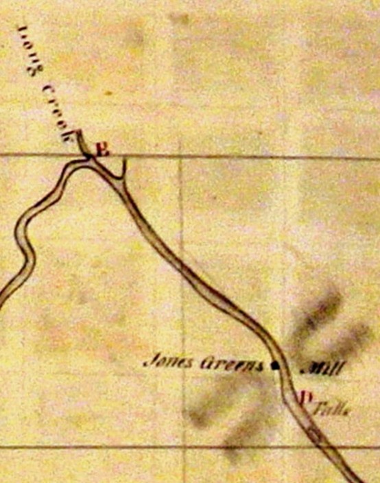
Some 20 years later, in 1798, the 250-acre tract was formally surveyed and patented not to Goin Morgan, but instead to his heirs. Having first acquired land far away on the east side of the Yadkin River, Goin was dead at the time of issuance. And then, four years following this patent to the heirs, Goin’s son Jonathan received a grant for 300 acres (see B) wrapping around the 250-acre tract. Jonathan’s land is legally described as adjoining John Morgan’s property to the west and William Brooks’ to the east. But how did John Morgan acquire the land mentioned in this case? Note also that the family built a mill near the river along with the establishment of a ford or river crossing downstream from the mill. Later, in August of 1843, shortly after the formation of Stanly County, the fledgling court ordered:
“twelve free holders to lay off a road from Morgan’s ford on Rocky River the best and most convenient way to intersect the old road at the ford of Island Creek that leads from the Big Lick to the Widow Little’s.”
The widow Little initially lived east of present-day Rene Ford Road, though later, her home was closer, I believe, to Hwy 200. The original route from Morgan’s Ford might connect to and align with the path of today’s Buster Road. Furthermore, Morgan Mill Road crosses the heart of Goin Morgan’s 250 acres where the historic Morgan Chapel stands in quiet testament of a lost era punctuated by a little-known effort to serve the spiritual needs of Germanic Lutherans flowing from Cabarrus County …likely in search of gold. Also, Drury Morgan is listed as an elder at nearby Flat rock Lutheran Church per an 1840 membership report. More on that in a future post, but wow, can you imagine the stories that the hallowed grounds at Morgan Chapel could tell?
To the west of Jonathan Morgan’s large tract lies two properties having origins unlike any recollected by most of us rooted in southwest Stanly County. In November of 1782, a time when preliminary articles of peace ending the American Revolution were signed, an entry of land (see C) later issued to West Gurley reads:

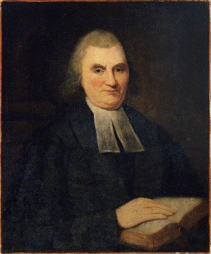
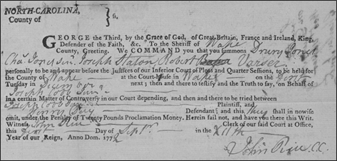
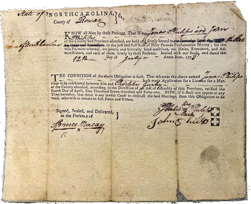
Courtesy of State Archives of North Carolina
“for William Brooks, one hundred acres of land for West Gurley opposite the mouth of Grassy Creek on the N. side including the plantation that Goin Morgan bought of Phereby Gurley.”
Grassy Creek rises in Union County and flows north until emptying into Rocky River near Hwy 200. So, the land in question is situated to the north of Rocky River, in present-day Stanly County, near the crossing at Hwy 200. But of importance, who is West Gurley, and for that matter, who is Phereby Gurley as spelled out in this land grant entry? Note that the names of women appear infrequently on Secretary of State land records from this early time. Much needs to be said about West and Phereby Gurley, but for now I need to introduce yet another person whose name is Jonas Phillips. The son of Reuben Clements Phillips of Rowan County and earlier of Maryland, Jonas made entry of one hundred acres joining both West Gurley’s survey along with “his own old line in the fork of Rock Hole Creek and Rocky River.” We know from this wording that Jonas Phillips owned additional land in the vicinity if not encompassing a part of Goin Morgan’s land. The 1798 survey (see D) of Phillips’ entry calls out Carson & Moore’s land to the north and confirms West Gurley’s land to the south.
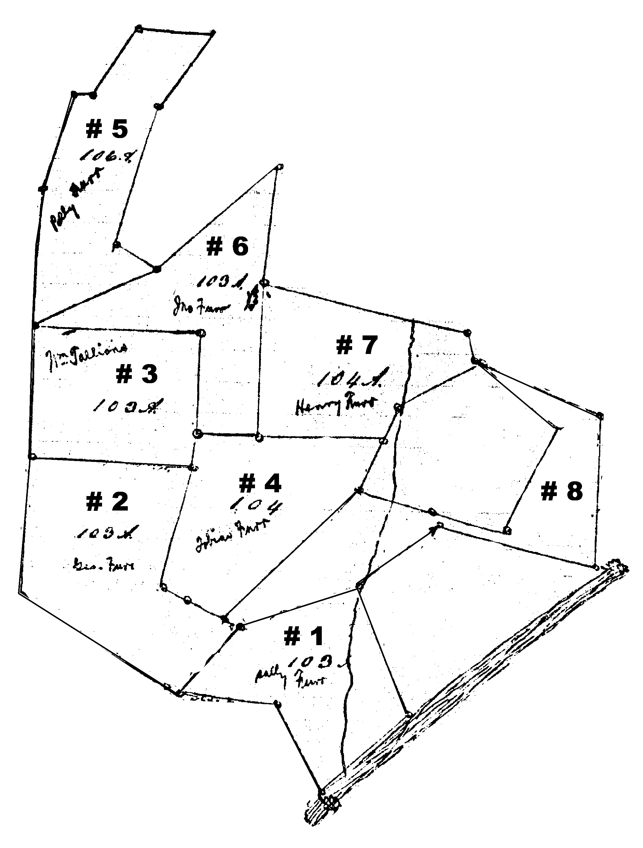
Jonathan Morgan’s son Drury received a grant for sixty acres (see E) in 1837. Adjoining this land is the tract granted to Jonas Phillips. Later, Jonas’ land is called out in Drury’s 1837 patent as being owned by John Furror (Furr). So, for some reason, John Furr of Cabarrus moved to or at least acquired land in present day Stanly County …again, think gold. The effort to establish a Lutheran church at Morgan’s certainly served the needs of people like John Furr. And note, John Furr’s land below present-day Stanfield is filed not in the annals of Stanly County, but instead, the large and wonderfully drawn division plat appears in the 1834 estate of John Furr found in the Cabarrus County deed book. The division (Cabarrus 14-139) does not mention or otherwise indicate in any way that the land is situated in what would soon become Stanly County. Furthermore, it is in this event that we can begin to anchor the movement of John’s children across the river into lands in present-day Stanly County. For the benefit of researchers, John Furr’s land was distributed as follows:
Lot 1: Sally Furr Lot 2: George Furr Lot 3: William Stallings Lot 4: Jacob Furr
Lot 5: Polly Furr Lot 6: John Furr Lot 7: Henry Furr Lot 8: Tobias Furr
 Back to Phereby Gurley. According to the declaration made in the previously mentioned land grant warrant to West Gurley, at the time of the 1782 date, Phereby was surely of legal age to rightfully own the “plantation” through purchase or possibly as beneficiary by dower or heir following the death of a relative. And beyond the obscure notation, a little bit of searching adds yet another twist as on 12 Jul 1778, Jonas Phillips and his brother John Phillips filed a marriage bond in Rowan County on behalf of Jonas’ marriage to none other than “Phirlebe Gurley.” A coincidence? …no way! Of note, Spruce Macay, being an up-and-coming attorney and mentor to young Andrew Jackson, signed the bond as a witness. So, it appears Jonas lived beside Phirlebe [Phereby] Gurley, who owned her own plantation and who would later marry the said Jonas Phillips.
Courtesy of State Archives of North Carolina
About the Gurley family, the term conflation truly applies as is the case with many North Carolina families of this early time. Meaning a “merging of two or more sets of information, texts, ideas, etc. into one,” attribution of early records representing a family may not be proven and therefore can easily lead to a seriously mixed-up understanding of ancestry. Most notable of the Gurley family who settled along the Rocky River happened to be brothers William (referred to in this post as William II) and Jacob Gurley who came from Johnston County. Records for multiple members of their extended family can be found in abundance spanning the counties of Johnston, Wayne, Duplin, Dobbs, Sampson, Edgecombe, and Bertie. With few of the documents clearly stating familial relations, how can we truly separate and attribute lineages from such a broad hodgepodge of possibilities?
As for Wiliam Gurley II, he settled on the south bank of Rocky River between its waters and Richardson Creek. This William wrote his last will and testament (LW&T) in 1804, in which he bequeathed to daughter Jean:
“one cow and calf also two three year old hogs spaid sows and barrows belonging to the Lauhon gang, also two hundred and fifty acres of land on the watery branch to be equally divided between her three boys Alexander Pool and William Pool and Nathan Pool …”
Execution of the will must not have gone to plan as a court ordered distribution of the estate of William Gurley II occurred some eleven years later. At that time, in 1815, the above-mentioned 250 acres bequeathed to Jean and her sons (all having at that time the last name of Pool) was split such that Jean’s brother James Gurley received the northern half of the property. Maybe the brother and sister got along, “gee-hawed” as my elders might say. Furthermore, instead of William’s daughter Jean appearing in division, Sander Pool is called out as recipient of the land bequeathed to Willaim’s daughter Jean. Sander is surely Jean Gurley’s husband, and he rightfully took ownership of the land on behalf of his spouse as was legally customary for the time. Maybe the bequeath by William Gurley II to his daughter along with his mention of her sons appearing in the LW&T was done so to make no doubt that he intended for the land to pass down to his Pool grandchildren.
Years later, in 1821, the above-mentioned Nathan Pool, then living in Kentucky, released his rights to the William Gurley II estate to “Lydia Pool” …no mention at that time of Sander. Also, William Pool of North Carolina followed suit with a release of rights to Lydia in 1826. Who is this Lydia person? Having no proof, I believe she was their mother, who was born Lydia Jean Gurley, the daughter of William II, and therefore the wife of Sander Pool.
The families of Gurley and Pool are deeply enmeshed as in the 1780s a person named Middleton Pool sold to William Gurley II two tracts of land on the Rocky River. How does Middleton relate to Sander? And, back in 1764 Johnston County, North Carolina, another instance of a person named William Gurley sold land on Moccasin Swamp to Alexander Pool. The land in question was called out as originally being “granted to Wm. Gurley Sr, bearing date 15th March 1756” and note that the deed was witnessed by John Austin and a person named Nathaniel [Nathan] Gurley. Nathan is mentioned as “son” in his father John Gurley’s LW&T probated in 1760. The exact relation between John and William Gurley II is not known.
Nathan Gurley died circa 1777 in Johnston County at which time his will mentions wife Anna, sons Arthur and Robert, and daughters Elizabeth and Fereby. Nathan appointed his “friend William Gurley Senr” to be executor and the will was witnessed by Wiliam Gurley Junior. Who are these people? Note that the father of William Gurley II is William Gurley I, who, from court minutes, died circa 1760. Therefore, the person referred to in this post as William Gurley I is likely “William Sr.” who patented land in 1756 though he cannot be the person named William Gurley who sold the same land to Alexander Pool in 1764. Neither can he be William Gurley Senr who witnessed the will of Nathan Gurley in 1777. Again, since the parentage of this William Gurley is not proven, he could just as easily be William Gurley II or another William, possibly the known son of John and therefore the brother of Nathan. Note that Nathan’s wife Anna [Anne] Gurley received a patent for land in Johnston County following the death of her husband. The land belonging to Anna Gurley passed to someone else and then to Needham Whitley who is acknowledged as a member of the large Whitley family who settled along Rocky River. Birds of a feather?
The wife of William Gurley I is named Mary and most believe her maiden name to be Mary West. Mary lived until 1792 when her LW&T names children William [II], Jacob, Isom [Isham], Rebeckah, Lida Pool, Mary Borwick, John, and Patty. Here we see the Pool name again, this time in a document involving the Gurley family a generation earlier. Note that the LW&T of Mary Gurley was witnessed by Needham Whitley, Patty (x) Gurley, and Isom (x) Gurley.
Beyond Wiliam II and Jacob Gurley, did others from the extended family move to the Rocky River region …an idea few have exercised? Per a pension request raised while living in 1832 Pickens County, Alabama, it is known that [Isom] Isham Gurley served in the Revolutionary War. His request was denied because he did not serve the minimum period required to receive compensation. However, the formal request provides the following:
“Since the Revolutionary War, he (Isham) removed to Anson County, North Carolina, where he resided about ten years, thence to Buncombe in the same state, thence to Pendleton, South Carolina, thence to Pickens County in the State of Alabama …”
Isham indeed lived in Anson where in 1804 the Secretary of State Land Grant office assigned him a patent of land on the Flag Fork of Watery Branch. The land was originally entered in 1796 by Michael Austin. James Gurley and John Lawhon, respectively the son and son-in-law of Isham’s probable brother William Gurley II served as chain bearers for the survey. Another brother, Jacob Gurley, sold two patented tracts in Johnston County before moving to Anson County.
There is a hint of deeper family interaction in the assignment of Michael Austin’s land grant to Isham Gurley. Also suffering from the dangerous temptation of conflation, Michael’s father is believed to be John Austin, who happened to marry Rebeckah Gurley back in Johnston County. Most of John Austin’s children, Richard, Bryant, Michael, John, Drury, Jacob, and Jonathan moved to the Rocky River region where their descendants make up the vast majority of those today carrying the Austin surname. Some moved to Lincoln County, Tennessee before spreading into Alabama and beyond. But who is John’s wife who genealogists attribute as being Rebeckah Gurley? Could she be the sister of Isham, Jacob and William Gurley II as appear in their mother’s 1792 LW&T? That’s the easy way to declare her ancestry albeit Rebeckah could also fit elsewhere within the larger Gurley family. If we only knew this one thing.
As for William Gurley II, the title history for lands he lived on prior to moving to Anson County is slim and confusing at best. It’s evident that William, son of John and Anna Gurley purchased land from Richard Pilkington lying on the Moccasin Swamp of the Neuse River in 1777. The idea makes sense as his mother Anna witnessed the deed. Yet, the other witness to this transaction happened to be John (x) Barwick, who must be the brother-in-law of the said William Gurley II, per the LW&T of Mary Gurley.
So, William II, who came to Anson County with his brother Jacob, is named after his father who is believed by some to have married Mary West. Furthermore, tradition holds that a person called West Gurley, who received a grant near the Morgan lands on Rocky River, is named for Mary West Gurley’s maternal ancestry.
Adding some flavor to the mix, before moving from Johnston to Anson County, North Carolina, in 1776, William Gurley II is possibly the person who sold 100 acres in Duplin County to James McClenny, whose extended family also became a prominent fixture in the annals of Anson County. This deed was witnessed by Thomas Strickland, Isom (Isham) Gurley (possibly the brother of William I), and Lewis Gurley (which makes one wonder).
In 1764, William Gurley, I believe William [II], sold land on Moccasin Swamp in Johnston County to Alexander Pool. The deed was witnessed by John Austin and William’s probable cousin Nathaniel Gurley. Nathan died circa 1777 at which time he appointed “his friend William Gurley Senr” to execute his last will and testament, which, at the time, leads one to think the will was signed by William Gurley II …but other possibilities exist. All I need is to know just one thing! Nathan’s LW&T mentions his daughter Fereby. Could Fereby have traveled to Anson County with her uncle and cousins’ family? Could she be the person mentioned in West Gurley’s land entry? Did she marry Jonas Phillips? Note that William Gurley II also had a daughter named Fereby, though she would surely be too young to be the same person mentioned in West Gurley’s land entry on Rocky River. And rereading West Gurley’s entry more closely, I ask again, how should we interpret the claim that the said Wests’ entry included the plantation that Going Morgan bought of Phereby Gurley?
Again, who is West Gurley, and for that matter, exactly who is Phereby Gurley? Though no proof exists, I ponder that he is likely the son of William Gurley I who died in 1760 Johnston County. West Gurley is believed to be named after his mother’s family and regardless, he settled briefly on land near the brothers Jacob and William Gurley II on the Rocky River. West is not mentioned in his believed mother Mary Gurley’s last will and testament filed in 1792 Johnston County, nor any other relevant document sourced in North Carolina. However, from Mary’s will and other documents in Johnston County, we have confirmed family ties to the Austin and Pool families whose relations remain intact through the Rocky River region, stretching all the way to Alabama. West Gurley moved to South Carolina by the mid-1790s where family histories indicate he married a person named none other than Mary Fereby. Another Phereby! …this time a maiden last name. Quite curious, all of this makes one pause upon seeing the name Phereby in conflicting historical documents including mention in the 1779 Montgomery County land warrant.
 Additional connections to the families already discussed can be found a short bit downstream on the Rocky River at a creek once called Stillwater Creek, now Coldwater Creek. Beyond Island Creek and rising in Oakboro (old Big Lick), Coldwater Creek flows south to Rocky River. It is somewhere in this area where, in 1790, Sander Pool patented 40 acres lying on both sides of the creek (right). I have yet to precisely locate the granted land though I believe it surely must be somewhere between the river and Oakboro. Note that William Gurley and James Gurley served as chain bearers for Sander Pool’s survey. One normally thinks of William Gurley when studying land and people who settled on the south side of Rocky River.
Entered eleven years earlier, in 1779, and issued in 1785, Alexander Pool Junior received a nearby patent for 94 acres (see F below), being the plantation that he lives on joining William Phillips on the north side of Rocky River. Note that Sander Pool and James Gurley served as chain bearers for this patent issued in 1790 Montgomery County. Likely too old to be the son of Sander and Lydia Jean Pool, could this be the same Alexander Pool who Wiliam Gurley I sold land to in 1764 Johnston County? Or could this person named Alexander be he who married Lydia, the possible sister of William Gurley II per their mother Mary’s LW&T? The exact location of Alexander Pool’s patent is difficult to determine though the site reveals itself per its mating to other land grants.
As already stated, at the time of survey, Alexander’s land adjoined that belonging to William Phillips who I believe acquired his land in part from John McCulloh. More later about William Phillips.
In 1804 James Gurley entered 135 acres (see G) called out as adjoining his own land to the west and south. And, a year earlier, James patented 150 acres to the west adjoining Austin and Brooks (see G2). Additionally, the 135-acre tract mates perfectly with Poole’s 94-acre tract indicating it had been purchased by the said Gurley from Alexander Poole, Junior. And again, there is also mention of William Phillips’ land adjoining to the east where it mates perfectly with a 50-acres tract (see I) issued to William Phillips, who is believed to be the brother of Jonas Phillips who married Pherile Gurley. Remember, William Phillips and William Pool served as chain bearers for the land issued to Alexander Pool, Junior. And note that James Gurley and William Phillip’s probable brother Jesse Phillips served as chain bearers on behalf of William Phillips’ 50-acre acquisition.
About the Phillips family, from earlier in Maryland, William and Jonas moved with their father Reuben Clement Phillips to the vicinity of Second Buffalo Creek in Rowan County. I have not sought to verify the family’s ancestry, although Revolutionary War pension records document his relinquishment of rights to future claims. As appears in an Aug 2000 Genforum inquiry,
“In 1776, William Phillips served under Colonel Locke and General Rutherford in a retaliatory strike against the Cherokees at Hiway in Tennessee. General Rutherford led 1900 men across the mountains. The casualties were buried at Third Creek Church. On February 9, 1778, William Phillips filed for 100 acres of land on the headwaters of Dutch Second Creek next to Andrew Holtshouser, Wendle Miller, and Jesse Phillips in Rowan County North Carolina.”
Little narrative exists on the Phillips family stay in present-day Stanly County. However, William Phillips’ declaration occurring in Overton County, Tennessee, reads as follows:
“In a filing dated January 12, 1841, the veteran stated that he lived in Montgomery County North Carolina before moving to Overton County Tennessee 20 years past.”
At this point we are I now need to discuss William Phillips’ 100-acre patent; the issuance is actually based on the combination of two 50-acre warrants bearing original file numbers 970 and 971 as follows:
No. Carolina} No. 970
Montgomery To the Surveyor of sd. County Greeting. You are hereby required to layoff & survey according to law for William Phillips a tract or parcel of land containing 50 acres on the waters of Rocky River on Still Water Creek above Wm. Phillips’ improvement. Observe the directions of the act of assembly made & provided in such case given from under my hand at office this 18 day of Nov. 1794 Jno Crump EJ
No. Carolina} No. 971
Montgomery To the Surveyor of sd. County Greeting. You are hereby required to layoff &survey according to law for William Phillips a tract or parcel of land containing 50 acres joining Aex’r Pool’s line in the fork of Still Water Creek the waters of Rocky River & joining Wm Phillips, including an improvement held by the sd. William Phillips. Observe the directions of the act of assembly made & provided in such case given from under my hand at office this 18 day of Nov. 1794 Jno Crump EJ
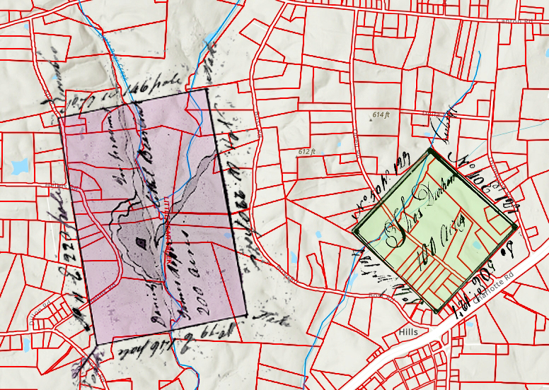
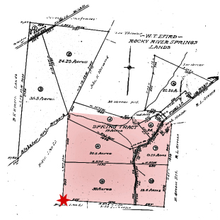
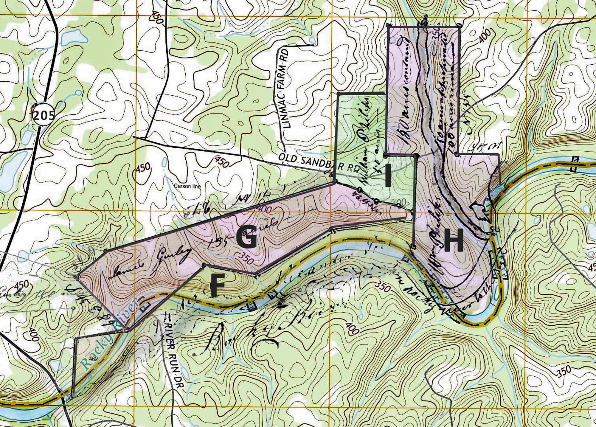
The survey plat (below) defined as both 100 and150 acres (green) occurred a year later at which time the two warrants are called out while the plat or legal drawing indicates “50 acres appropriated – 100 acres remains” (red). The discrepancies are made clear by the surveyor: “after deducting 50 acres out of the above plan which is held by the said Phillips” (blue). In other words, this survey is a bit atypical in form because it encompasses land outside of the entry.
Appearing in another warrant and the resulting issuance of land on Still Water Creek, 14 years before William Phillips patent, a person named David Matheny also received a warrant for 50-acres “on Still Water of Rocky River on No. side of sd. Creek including his improvement.” The survey and documents call out “Daniel” Matheny, not David. The survey plat incorporates similar metes and bounds, matching perfectly the lie of land on the southern end of the larger tract later patented to William Phillips. It is in that observation I believe William Phillips’ “50 acres appropriated” was initially granted to David or Daniel Matheny. Furthermore, and of interest, the chain bearers for Daniel Matheny’s survey happen to be Daniel Matheny and a person named Thomas Sims. Note that a family member is named Simms Matheny and unsubstantiated history indicates they may have resided on Richardson Creek in Anson County at least through the early 1800s.
 The above relates to much of the lower half of William Phillips grant incorporating 50 acres earlier patented to Daniel or David Matheny. But there is more. The legal description for the Matheny survey describes the final and southern-most line of that survey as running from a “hickory in McCulloh’s line then east 90 poles with McCulloch’s line to the beginning.” The N/S measurement for the western boundary of the lower half of William Phillip’s 150-acre patent is simply too short unless land below Daniel Matheny’s entry (pink) is considered.
Beyond mention and though owning numerous small tracts nearby, there appears to be no surviving document supporting this land as once owned by “McCulloch.” That being stated, I have no doubt that the land in question likely belonged at one time to Henry Eustus McCulloch, the son, surveyor, attorney, and agent of Henry McCulloch who, as a speculator, brilliantly acquired 1.2-million-acres through dealings involving James Huey and Murray Crymble. As alluded to in Matheny’s entry, the edited plat (right) incorporates the ideas presented. The pink shaded area belonged to McCulloh. Daniel Matheny received the patent for the green shaded area while the survey for William Phillips’ two warrants incorporated it all.
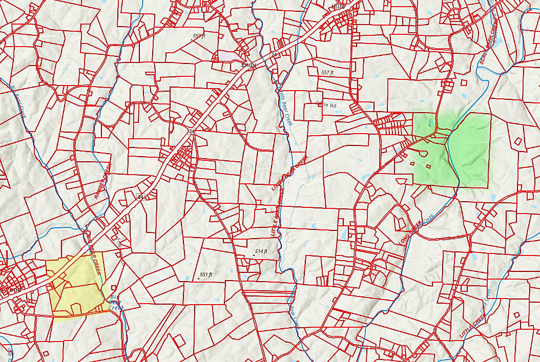
The mouth of Coldwater Creek is known, a given. Would be interesting now to look at the present-day Stanly County GIS map from which one could trace the land back in time to the founding of Stanly County. The jump back at that point to origin may remain untold as defined by the gap in available records. However, as for William and his brothers Jesse and Jonas Phillips, and for the Gurley, Pool, Morgan and Brooks family, the above adds something new to what is known about the community where they once lived. In conclusion, there is much to learn in piecing together land records. This post has attempted to outline bits and pieces concerning ownership and how life can be breathed into little known stories of first settlers and how they interacted with one another.
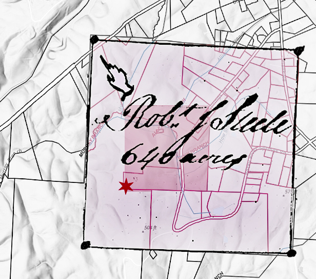
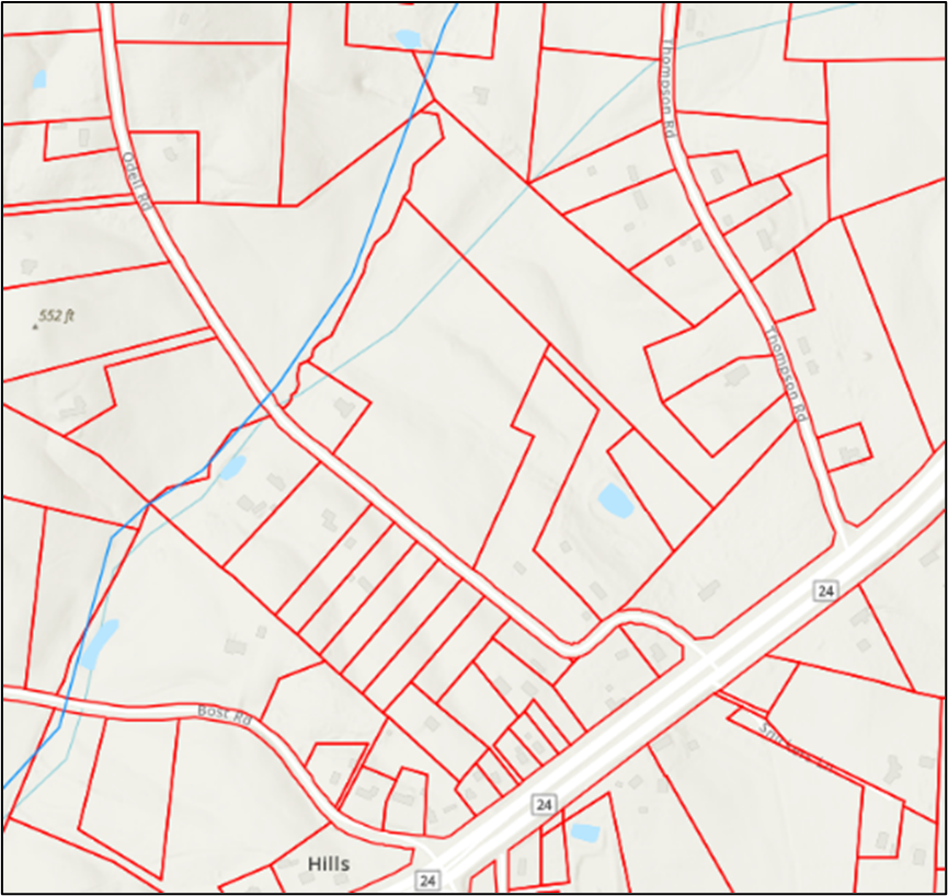 North of 24/27 and nested between today’s Thompson Road and Bost Road in Stanly County lies a diamond-shaped visual echo of our distant past, see it? Going back to 1780, a person by the name of Thomas Durham entered 100 acres “on both sides of Little Bear Creek, including some improvements.” As can be clearly seen on the image, passing through the northern end of the tract is a stream most people today call the Little Branch of Little Bear Creek. However, from the original survey, which occurred 12 years after the entry, we learn of that time, the tract was described as located on “both sides of a Little Creek or a branch call’d Daniel’s Branch.” Creeks often go by different names and that seems to be the case with this stream.