My years camped out in the reading room at State Archives of North Carolina have given me a useful sense of many early families and their journeys across our state. Nearly as much as what I have learned from my own research, I also gleaned valuable insight from others as they approached the Archives “search desk” to voice their own unique requests for help. And of everything that I overheard, I particularly remember an older lady, an annual pilgrim you might say, who made numerous drives from Arkansas in search of her Yearby/Irby ancestors. We became friends and search buddies. I no longer remember her name though I do remember this lady routinely emailed me when she was enroute to her favorite place here in North Carolina.
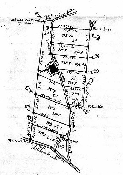 As was the case with my ancestral family who made a significant stop in Anson and Montgomery Counties, my friend’s family was similarly drawn to the region surrounding the Rocky River. We had fun plowing the old papers though I will never forget her more recent ancestry descending from Hudson Yearby and his son Riley who both lived here in Wake County. You see, according to his final estate, Riley Yerby owned land at the corner of “Hillsboro” Road and the “Ridge Path” which latter road I believe reflects an early iteration of today’s Ridge Road. Now ending on Wade Avenue near Whole Foods Market, did the old Ridge Path run further, through what is now the campus at Meredith College? And located within the heart of Riley Yerby’s land happened to be a church. See it? I always wondered if this was a Baptist Church and whether Riley’s demise played into the 1920’s relocation of Meredith College from its beginnings in downtown Raleigh. Also, I’ve recently learned of a family cemetery once located on the campus beside the old Rotunda Building.
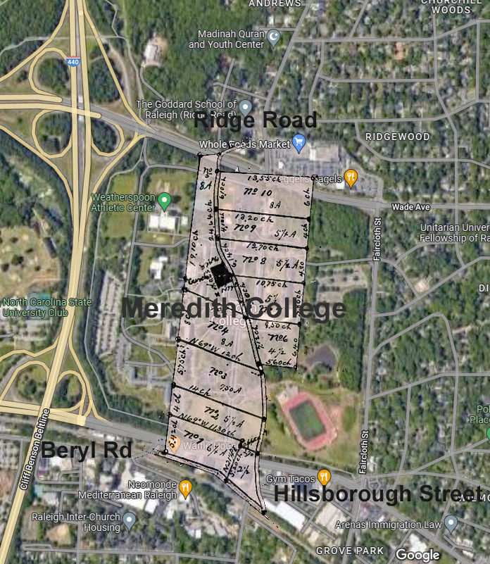
To go a step further with the mapping, the following overlays Riley Yerby’s estate plat atop today’s Google mapping imagery. And while hastily putting together the collage, my mind went back to a conversation with Cheyney Nicholson whose father founded nearby Capitol City Lumber. I remember Mr. Nicholson telling me how the old Hillsboro Road did not run the route it does today. He said the road once ran the same path as nearby Beryl Road upon which Capitol City Lumber Company is located. Mr. Nicholson remembered as a child when Hillsboro Road was dirt and of his amazement when the main artery into town was first paved. Today the direction and bend of Hillsborough below seems to confirm the accuracy of both the estate platting and Mr. Nicholson’s memory of what once was.
Just the other night I had reason to remember my old friend from Archives. But first, note that I recently discovered a 1772 Wake County civil actions paper naming Gideon Green and Joseph Thomas. This and other documents now lead me to believe Gideon is the son of Leonard Green who also lived in the area and had frequent dealings with Joseph Thomas of Wake County.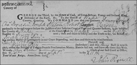
Moving across the state, in 1783 Anson County, Gideon Green received a land grant for 150 acres on both sides of Richardson Creek for which Benjamin Thomas, my ancestor, served as chain bearer. I now hypothesize that my Benjamin is the son of a person named Jacob Thomas who, a year earlier, received a land grant a few miles downstream on Richardson Creek. Gideon Green ultimately sold his 150-acre Anson County tract to Benjamin Thomas in 1785. Witnessed by Charles Harrington from earlier in Chatham County and William Gurley from earlier in Johnston County, that conveyance represents Gideon’s last known record in Anson County.
 Overlaid atop the 1907 Miller map of Union County, once Anson County, Benjamin Thomas’s 150 acres purchased from Gideon Green is shown above in red. See it? The larger road running through the tract also shaded red represents present-day Pleasant Hill Church Road. The purple road to the north is today’s Fish Road and the pink road near the bottom is Hwy-218. The yellow shaded road crossed at Nance’s Mill Ford before passing northerly through the lands of owner Wyatt Nance. And for the small green shaded road, it crossed over Richardson Creek at what was called Charity Ford before passing the location where our Thomas family cemetery was once located. Per the labeling as seen in the 1907 map, the Thomas family remained a fixture on the lands they settled.
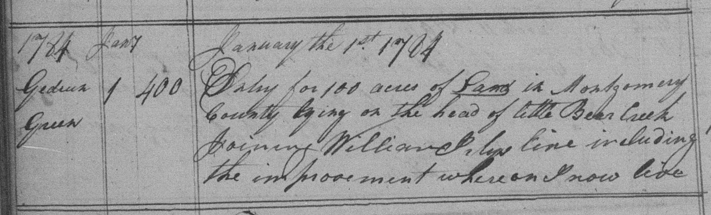
Now, upon reviewing tax lists and early land entry records to the north, across Rocky River in what became Montgomery County, now Stanly County, I have recently been able to advance what is known of the Green family narrative. First, in 1784 and being a year before Gideon Green sold his land to Benjamin Thomas, the said Gideon entered 100 acres on the head of Little Bear Creek (below). Note below that Gideon’s entry adjoined the lands of William Irby, who happens to be none other than the person who raised the attention of my old research friend from Arkansas. And per the 1784 entry, at that time, the document states that Gideon lived in an improvement situated on the land. We now know why Gideon Green sold his land to my ancestor because he was in process of relocating across the river.
Before flowing into Long Creek near St. Martin’s Lutheran Church, Little Bear Creek rises to the north where Gideon’s entry was likely located near the present-day community of Millingport. And as for this land grant entry, there is no record of its issuance and therefore nothing survives indicating Gideon ultimately took possession of the land. And looking beyond land grants to tax records, all that survives for early Montgomery County is one document being the 1782 tax list as shown in part below.

No tax entry for Gideon Green exists. In 1782 he apparently did not live in or own land in Montgomery County. However, note that his likely father, “Lenard” Green, was assessed 39for 150 acres, three horses, and fourteen cattle. And yet Lenard Green does not appear as entering land in Montgomery County though a person of that name appears as chain bearer for two pieces of land along Rocky River: Phillip Self received 100 acres on the fork of Island Creek and in 1783 Job Pendergrass received 150 acres joining the “Self improvement” on Island Creek. It may be possible that Job is the person listed in Revolutionary War records as having his ear shot off at the Battle of Kings Mountain. He later lived in Burke County, and he may be the person of that name listed in the 1790 census as living in Orange County. Regardless, I imagine Leonard Green lived close to Phillip Self and Job Pendergrass on Island creek to which his taxable 150 acres in 1782 raised my curiosity in connection with the land of same amount issued to the said Job Pendergrass a year later. Also, on 1 Feb 1780, Leornard Green and wife Ann sold land (11-9, Meck NC) in present-day Cabarrus County on the west side of Rocky River at the crossing of Highway 24/27. Leonard sold the land to Samuel Bonds who was a well-known Baptist preacher. Witnesses for the transaction were Wm. Haynes, who is the namesake of nearby Haynes Meeting House, and Jacob Self who happens to be the brother of Phillip Self above.
The technique of “cluster genealogy” employed in this sort of research has allowed me to see beyond my goal of understanding the growth and movement specifically related to my family. Sometimes I think the term cluster is a might sterile as the inclusion of friends and neighbors in context of family growth and westward expansion bespeaks loudly of community. And totally under the researcher’s control, one can choose how deep into time and community their efforts will reach. Note on the 1782 Montgomery County tax list that besides Lenard Green, two additional people named Richard Green are also enumerated. What is the significance for the name Richard and for that matter, how about for Lenard? And why would there be two people by the name of Richard Green in early Montgomery County? Catching my attention when I first began back in the 1990s, I found the following 17 May 1763 entry in the Cumberland County Pleas and Quarter Session minutes:
Whereas a road is laid off from Nuce River to Braswell’s Ferry on the Cape Fear River and the road is opened and cleared to the Johnston line, ordered that there be a road from the said Johnston County line; Wm. Cone appointed overseer. Constable of the uper district to summon all the following to appear before a justice of peace on or before the second Tuesday in July to qualify and make a jury to lay off said road:
Wm. Cone, Samuel Green, Leonard Green, Robert Pettigro, Charles Broom, Wm. Corbett, Denis Collins, Absolem Tyler, Abden Tyler, Moses Tyer, James Holland
and Shadrack Pope.
And in Dec 1772, in the newly formed Wake County, Pleas and Quarter Session minutes records the following:
Ordered that the following Persons be appointed a Jury to lay of a Road from James Quantocks to the County line agreeable to the Order passed last Court (towit)
Jacob Utley, James Quantock, Christopher Woodward, Lewis Jones
Landman Short, Francis Settles, Christopher Osborn, William Barker
Henry Day, James Holland, Richard Green, Anthony Holland
Lazarus Hood, Joseph Thomas, and that John Utley be appd. Constable to summons said Jury.
In the earlier Cumberland County road order, listed beside one another are Samuel and Leonard Green. I’ve never researched Samuel but also mentioned are James Holland and Shadrack Pope who should both considered worthy of research as they are within our cluster or community. And in the second road order in newly formed Wake County, it’s pretty cool now to see Leonard Green and Henry Day while knowing their earlier mention in a civil action paper naming the said Henry Day alongside Gideon Green who happened to sell my ancestor his first land in Anson County. Suddenly I have been able to change my assessment of family ties from being possible to highly likely. Also, I have recently written much about the Utley and Barker families though take a second to notice James and Anthony Holland ordered side-by-side to lay off the new road. The two are certainly related and yet seldom do you see them together in Holland family histories. I believe that’s an oversite. And lastly, the name Shadrack Pope from the first and earlier Road order is hugely important as in records going back to 1750’s Edgecombe County, Joseph Thomas, Richard Green, and Anthony Holland came together in settling matters related to the estate of the said Shadrack Pope’s father. Not only do we see community in Wake County, but their togetherness will also become evident when we turn attention to the east, to Edgecombe County.
I can choose to limit my research at any point yet so much is gained by tweaking spheres of influence. James Holland died in Wake County whilst Anthony continued on and moved west through Montgomery County where he lived near William Yerby. As for the two men named Richard Green taxed in Montgomery County, were they father and son or possibly uncle and nephew? And as will be seen, expanding the scope of research to include these men will illuminate others whose published narratives omit their passing through Montgomery County. Often family histories are told from viewpoint of a perceived starting point and the finality of death yet understanding tells us life is filled with significant stops along the way. My next post will similarly tell the story of community and how its richness grew as members divided and moved across our state.

Thank you again! You are an amazing researcher and historian. I’m impressed with the attention to detail with both simplistic easy to understand accounts, accompanied by more complex intellectual assessments and critiques of ongoing topics related to the family history of people of color and other settlers as early as the 1700’s. Fascinating reading. Can’t thank you enough. I’m related to the ESTELL, WALDEN, DERRICKSON AND STUART FAMILIES OF THE LOST CREEK SETTLEMENT, Curtis House