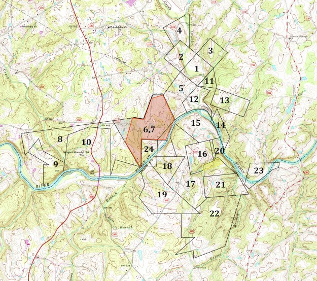
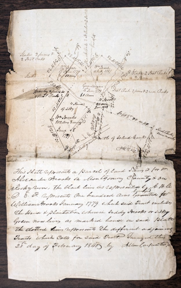
In this post I’ve begun to lay out the land grants and deeds anchored by way of the eviction plat appearing in the case of Alexander Brooks vs. Siddy Brooks. This is not to be considered a final work but is merely a starting point for understanding the neighborhood. The location of these tracts will become better understood as research expands to plat pieces of land yet further afield. It is now pretty close to correct and should provide a great starting point for those interested in the families in this area.
_______________________________
Map Key 1, Grant 258, Montgomery NC, ent. 10 Dec 1779, sur. —-, iss. Oct 1783. Issued to GOIN MORGAN, being 50 acres on both sides of Island Creek beginning at a pine a corner tree of Captain William Brooks and running thence north 51 west 90 poles to a stake second corner of said Brooks, then north 39 east 90 poles across said creek to a stake, then south 51 east 90 poles, then north 39 west 90 poles crossing said creek to the beginning including Benjamin Bowlings improvements. Chainbearers: Goen Morgan, Arthur Poole.
Map Key 2, Grant 88, Montgomery NC, ent. 10 Dec 1779, sur. —-, iss. 11 Oct 1783. Issued to WILLIAM BROOKS, being 50 acres on Island Creek beginning at a pine corner of Goin Morgan and his own running north 51 west 90 poles to a stake, then north 39 east 90 poles across Island Creek to a stake, then south 51 east 90 poles to a stake on Going Morgan’s line then with said Morgan’s line north 39 west 90 to the beginning. Chainbearers: John Austin, Bryant Austin.
Map Key 3, Grant 1034, Montgomery NC, ent. 31 Oct 1794, sur. —, iss. 10 Jul 1797. Issued to WILLLIAM BROOKS, being 50 acres beginning at a red oak in his own line by a red oak, post oak and pine pointer and runs south 51 east 100 poles to a white oak by a red oak then north 39 west 80 poles to a stake by three red oak pointers, then north 51 west 100 poles to a stake, then to the first station. Chainbearers: Jno Brooks, Jonathan Whitley.
Map Key 4, Grant 996, Montgomery NC, ent. 31 Oct 1794, sur, 29 Mar 1796, iss. 10 Jul 1797. Being 100 acres at the mouth of Camp Branch issued to JOHN BROOKS beginning at a hic in William Brooks’ line on the west side of Island Creek & runs north 136 poles crossing said creek three times to a post oak, then west 36 poles to a stake between two red oaks & post oak pointers at the mouth of Camp Branch, then south 18 west 4 to a stake between a hickory, Spanish oak, & white oak, then south 61 west 102 poles to a pine, two pine pointers, then south 30 east 112 to a post oak in Wm. Brooks’ line, then with his line north 39 east 47 poles to his corner, then to the first station. Chainbearers: Wm Brooks, Caden Whitley.
Map Key 5, Grant 125, Montgomery NC, ent. 20 Nov 1782, sur. —, iss. 11 Oct 1783. Issued to WILLIAM BROOKS, being 100 acres on the northeast side of Rocky River beginning at a pine upper corner of said Brooks’ and running thence north 59 west 89 poles to a stake, then south 31 west 120 poles to a stake, then south 27 east 122 poles to the river, then down the various courses of the river north 27 east 87 poles to the said Brooks’ corner on the river, then north 22 west 34 poles with the said Brooks’ line to his second corner, then north 42 east 96 poles with his own line to the beginning. Chainbearers: Goen Morgan, Arthur Pool.
Map Key 6, Grant 1848, Montgomery NC, ent. 11 Nov 1802, sur. 1 Jun 1805, iss. 20 Dec 1805. (shaded red) Being 200 acres issued to WILLIAM BROOKS SENR. situated on Rocky River beginning at an ash by a red oak his own old corner & Jonathan Morgan’s corner on the said river and runs north 32 west 100 poles, then north 7 east 136 poles to a gum, then south 80 east 40 poles to a pine, then north 21 east 110 poles to a red oak & red oak pointer, then north 70 east 40 poles to a red oak and two dogwoods, then north 42 east 10 poles to corner red oak in said Brook’s line, then south 27 east 132 poles with his own old line to the river stake and hickory & two re oak pointers, then up the various courses of the river south 132 poles to a “lyn” corner in his upper tract then west 96 poles to a pine, then south 130 poles to the first station. This grant is colored red to separate it from an earlier duplicate that apparently was never issued (see Grant 052). Chainbearers: Wm. Brooks, David Brooks.
Map Key 7, Grant 052, Montgomery, ent. 07 Oct 1800, sur. —, iss. (was not issued). Very similar to Grant 1848 which was also entered by William Brooks. Note with this grant record the file number begins with a zero. That’s very important as Secretary of State land grants that have problems or were not issued are grouped together by file numbers beginning with a zero. This tract is very similar to 1848 above and was entered a year prior to the above 1848. Though never issued, it does include a survey with chain bearers being Jonathan Morgan and Mark Morgan.
Map Key 8, Grant 1589, Montgomery NC, ent. 7 Apr 1800, sur. 28 Apr 1801, iss. 20 Aug 1802. Being 300 acres of land on the waters of Rocky River issued to JONATHAN MORGAN beginning at William Brooks’ and his own corner ash on the river bank and runs north 30 west 240 poles to a pine by a pine and post oak in Carson’s line, then with said line south 80 west 428 poles to John Brooks’ corner then with or near said line south 10 east 110 poles to a stake, then north 35 east 98 poles to a stake by some pointers, then south 25 east 60 poles to a red oak, then south 60 east 118 poles to a stake on his old line, then north five east 102 poles to his corner, then north 60 east 100 poles to his other corner, then south 85 east 100 poles to his other corner, then south 200 poles to his corner hickory on the river, then with his line of his other tract north 13 east 100 to his corner, then north his other line south 77 east to the beginning. Chainbearers: William Brooks, Mark Morgan.
Map Key 9, Grant 2827 Montgomery NC, ent. 5 Oct 1835, sur. 17 Jul 1837, iss. 30 Sep 1837. Issued to DRURY MORGAN, being 60 acres on the north side of the Rocky River. Beginning at a rock on the bank of said river and runs thence his own line of his 250 acre tract north 5 east 19 chains and 50 links crossing Rock Hole Creek to a stake then north 60 west 25 chains to a red oak, then north 20 west 15 chains to a stake by a hickory and two post oaks, then south 35 west 13 chains and 75 links to the intersection of Furror’s 100 and his 30 acre tracts, then with a line of the 100 acre tract south 54 east 27 chains to the corner, then west 6 chains to another corner, then south 25 chains to the river, then down the meanders to the beginning. Chainbearers: Jos. Ramsey, Henry Morgan.
Map Key 10, Grant 1105, Montgomery NC, ent. 10 Dec 1779, sur. 3 Oct 1796, iss.13 Dec 1798. Issued to the HEIRS OF GOWIN [Goin]MORGAN, being 250 acres beginning on a hickory on the bank of Rocky River below the fish trap and runs north 50 chains to a pine, then north 85 west 25 chains, then south 60 west 25 chains to a post oak, then south 5 west 45 chains crossing Rock hole Creek to a stake on the bank of the river, then down the river with the various courses to the first station. Chainbearers: Mark Morgan, John Cheek.

William Thornton, Desgner of the U.S. Capitol Building
Map Key 11, Grant 1912, Montgomery NC, ent. 5 Jan 1808, sur. —-, iss. 6 Jul 1812. Issued to WILLIAM BROOKS being 21 acres on Island Creek beginning at one of his own old corners and runs north 39 east 100 poles crossing said creek to a post oak William Thornton’s corner and his own, then with said Thornton’s line south ten east 88 poles to a red oak said Thornton’s corner, then south 83 west 80 poles crossing said creek to the first station. Chainbearers: John Brooks, Alexander Brooks.
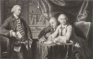
George Augustus Selwyn, Richard Edgcumbe, and George James Williams
Map Key 12, Deed H1-111, Anson NC, 3 Mar 1767. GEORGE AUGUSTUS SELWYN of County Gloucester in the Kingdom of Great Britain Esq. (as son and heir of John Selwyn Esq. deceased) of one part to WILLIAM BROOKS of Anson County in the Provence of North Carolina in America planter. Being part of the tract of 100,000 acres of land commonly called or known by the name of Tract number 1 lying on the north side or Rocky River on both sides of Island Creek beginning at a white oak on the bank of the said river running thence north 12 west 55 poles to a white oak, then north 40 west 80 poles to a hickory, then north 33 east 60 poles to a black oak, then north 71 west 60 at 30 poles crossing Island Creek to a pine, then south 31 west 100 poles to a pine, then south 27 east 34 poles to a white oak on the river bank., thence down the river to the beginning.
Map Key 13, Grant 999, Montgomery NC, ent. 31 Oct 1792, sur. —, iss. 10 Jul 1797. Issued to WILLIAM BROOKS being 100 acres beginning at a red oak between sweet gum and two black gums on the waters of Island Creek and runs thence north 70 east 180 poles to a stake between a hickory and post oak sapling, then north 70 west 180 poles to a stake in his line, then with his line to the beginning. The survey shows that the eastern most line adjoins Rocky Branch. Chainbearers: Exodus Whitley, Jonathan Whitley.
Map Key 14, Grant 235, Montgomery NC, ent.10 May 178o, sur. —, iss. 11 Oct 1783. Issued to WILLIAM BROOKS, being 100 acres on the northeast side or Rocky River beginning at a water oak on the river bank and running north 24 east 89 to a stake, then south 20 east 179, then south 24 west 89 poles with John Austin’s line to the river, then north 20 west 179 poles up the various courses of the river to the beginning. Chain bearers: John Austin, Bryan Austin.
Map Key 15, Grant 4806 Anson NC, ent. 17 Mar 1784, sur. 27 May 1787, iss. 16 Nov 1790. Issued to WILLIAM BROOKS being 150 acres beginning at four hickories on the south bank of Rocky River and runs south 55 east 150 poles to a pine, then north 75 east 106 poles to an ash 2 black oak pointers on the bank of Rocky River, then north 35 west up the river to the lower end or pine Island, then to the north bank of the river, then with the river up opposite the beginning, then south 55 east 6 poles crossing to the first station including Pool’s improvement on a small island. Chainbearers: James Phillips, West Gurley.
Deed R-23, Anson NC, 26 Feb 1810, reg. Jul 1815. WILLIAM BROOKS SENR. of Montgomery County to JOHN BROOKS being 150 acres including Joshua Phillips Improvement. Wit. Jacob Austin, Bryan Austin.
Map Key 16, Grant 6058, Anson NC, ent. 12 Mar 1810, sur. —-, iss. 12 Dec 1812. Issued to JESSE BROOKS being 100 acres adjoining his old land on the bank of the Rocky River beginning at an ash on the bank of Rocky River by a patch of red oaks and runs south ten east 93 poles to a pine by a red oak, then south 76 west 93 poles to a stake by three red oaks, the south 12 west 40 poles to a stake by two red oaks, the south 93 west 58 poles to a stake by 2 pines and a red oak, then north ten west 125 poles to a pine by two pines in his old line, then to the beginning. Chainbearers: ———
Deed R-16, Anson NC, 10 Mar 1815, reg. Mar 1815. JESSE BROOKS of Anson to JOHN BROOKS of Montgomery, being 100 acres on Rocky River joining the 150 acre tract formerly belonging to the said Jesse Brooks but now belonging to John Brooks. Wit: Jac. Austin, William Brooks.
Map Key 17, Grant 5748, Anson NC, ent. 10 May 1801, sur. —-, iss. 2 Feb 1804. Issued to MICHAEL AUSTIN, being 300 acres on Rocky River beginning at a water oak by two more on the river at the mouth of Sisco’s Branch and runs north 40 west 100 poles to a Spanish oak on the river bank two more, then south 67 west 20 poles to a stake in William Brooks line with it, then south 12 east 20 poles to his other corner, then with his other line south 38 poles 75 west 96 poles to his corner sweet gum, then with his other line south 10 west 40 poles to his other corner, then south 75 west 60 poles with it north 12 west 138 poles to his corner red oak by two pines, then north 77 east 67 poles to Brook’s corner, then with his line north 55 west 150 poles to his corner hickory on the river bank by two hickories, then south 18 west 60 poles to a stake in the river, then south 15 east 102 poles to a stake Wm Brooks’ line with it east 55 poles to his corner post oak by a pine and post oak, then south 36 west 156 poles to a pine Lahorn’s line, then with it south 50 east 166 poles to Jesse Brooks’ line, then with it north 50 east 76 poles to a stake, then north 60 west 12 poles to Rich’d Austin’s corner, then with his line north 9 west 96 poles with it north 85 east 160 poles, then a direct line to the beginning. Chainbearers: —- —-
Deed N-261, Anson NC, 10 Oct 1810, reg. Oct 1810. BRYAN AUSTIN SENR. of Montgomery County to his sons JACOB and BRYAN AUSTIN for and in consideration of the love and affection which he hath and beareth to his beloved sons. Being 20 acres of the 300 granted to Michael Austin. Witnesses: J. Culpepper, W. Hammond.
Map Key 18, Grant 5726 Anson NC, ent. 13 Apr 1797, sur. 15 Dec 1799, iss 14 Dec 1803. Being 80 acres of land on Rocky River issued to WILLIAM BROOKS beginning at John Lawhorn lower corner post oak by three black oaks and two pines and runs down the river the various courses nine chains to a stake in his line, then with it east 40 chains to a post oak by two post oaks and one pine & black oak and pointers, then south 36 west 39 chains to John Lawhorn’s corner stake by two white oaks and own line, then on said line north 43 west 33 chains and 75 links to the beginning. Chainbearers: Jesse Brooks, Will H. Davidson.
Map Key 19, Grant 5376, Anson NC, ent. 10 Jan 1797, sur. —, iss. 7 Jun 1799. Issued to JOHN LAUHON, being 200 acres on Rocky River beginning at a black oak by hickory ad two pines and runs north 40 west 21 chains and 20 links to a black oak, then north 28 east 14 chains and eighty links to a pine, then north 15 west 11 chains and 25 links to a Spanish oak in the bank of the river, then down the river 20 chains to a post oak, then south 43 east 33 chains and 75 links to a pine, then south 55 east 50 chains to a stake, then to the beginning. Chainbearers: ——–
Deed L-139, Anson NC, JOHN LAUHORN to BRYAN AUSTIN being 100 acres. Witnesses Jacob Austin, Petr McIntyre.
Deed N-205, Anson NC, 28 Jan 1807, reg. Jan 1810. JOHN (x) LAUHORN to JACOB AUSTIN being 100 acres. Witnesses: Bryan Austin, William Austin.
Deed Q-24, Anson NC, 24 Aug 1816, JACOB AUSTIN to JOHUA PHILLIPS, being part of a tract of 200 acres conveyed by John Lauhorn.
Map Key 21, Grant 5779 Anson NC, ent. 8 Jul 1797, sur. —-, iss. 26 Nov 1805. Issued to RICHARD AUSTIN, being 100 acres on Syscos Branch beginning on the east side at a red oak and running south 84 west 40 chains to a stake by three pines, then south 10 east 22 chains and 50 links to a post oak, then north 84 east 50 chains to Austin’s line, then with it to the beginning including said Austin’s House and part of his improvement. Chainbearers: John Austin Senr, John Austin Junr.
Deed N-205, Anson NC, 2 Feb 1807m reg. Jan 1810. RICHARD AUSTIN to JACOB AUSTIN being 100 acres on both sides of Suscoe’s Branch. Wit: William Austin, Bryan Austin.
Map Key 22, Grant 5928, Anson NC, ent. 2 Feb 1808, sur. —, iss. 30 Nov 1810. Issued to JACOB AUSTIN, being 200 acres on Rocky River beginning at a rock between three pines said Austin’s corner and runs south 84 west 115 poles to a post oak Richard Austin’s corner, then south 65 west 14 poles to a post oak, then south 50 west 98 poles to a stake, then south 55 east 27 poles to a pine Lauhorn’s corner, then with his other line north 89 west 94 poles to a pine, then south 100 poles to a stake by two post oaks, then east 70 poles to a stake by two post oaks, then south 50 west 106 poles to a stake by two pines, then south 42 west 20 poles to a stake near a path, then north 70 east 100 poles to a stake, then south 3 east 40 poles to Jacob Austin’s corner pine, then with his line north 67 east 148 poles, then with his other line to the beginning. Chainbearers: Jonathan Austin.
Map Key 23, Deed H1-124, Anson NC, 28 Feb 1767. GEORGE AUGUSTUS SELWYN of the county of Gloucester in the Kingdon of Great Britain Esq. (as son and heir of John Selwyn Esq. deceased) to JOHN SUSCOE being part of a 100,000 acre tract commonly known as Tract 2. Being 100 acres on both sides of Rocky River beginning at a black oak on the south bank of the river below his plantation and runs thence south 38 west 40 poles to a black oak, then south 82 west 45 poles to a black oak, then south 56 west 150 poles to a black oak above his barn, then north 40 west 36 poles to a white oak, then north 15 east 110 poles to a persimmon on the river bank crossing the river in all 100 poles to a stake, then to the beginning. Wit: Thos. Frohock, William Frohock.
Deed 7-193, Anson NC, 27 Sep 1779, reg. Jan 1780. JOHN FRANCISCO of Mecklenburg to JOHN AUSTIN of Anson being the 100 acres deeded from George Augustus Selwyn to John Suscoe. Wit: Tindal Roland, Cuyerline Roland.
Deed H2-393, Anson NC, 2 Mar 1801, reg. Jul 1802. JOHN AUSTIN SENR. planter of one part to BRYAN AUSTIN of Montgomery planter of the other part being 35 acres on the south side of Rocky River below the mouth of Suscoe’s Branch being part of 100 acres lying in in the counties of Anson and Montgomery. Beginning on a large pine sd. Austin’s fore and aft tree in the low ground of the river and runs then south 58 west 63 poles to a black oak, then north 40 west 36 poles to a white oak, then north 15 east 11 poles to a persimmon on the river bank, then crossing the river, thence down the river crossing to the beginning. Wit: Jacob Austin, Michael Austin.
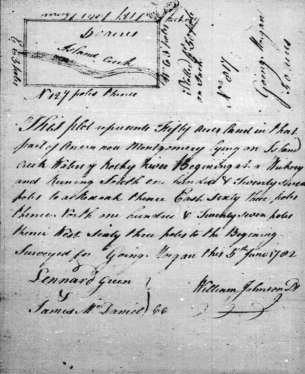
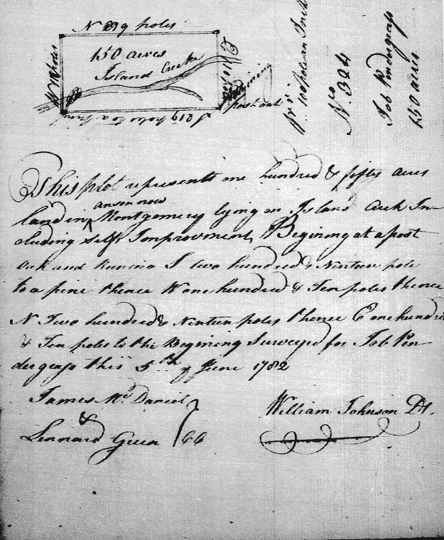
Map Key 24 – The following two grants have yet to be placed. However, it’s possible that one or the other is located at Map Key 24 on the north side of the river:
Grant 45, Montgomery NC, ent. 10 Dec 1780, sur. —, iss.11 Oct 1783. Note that this may not be Grant 45 but rather 48 …more on that in the future. Issued to GOING MORGAN, being 50 acres on Island Creek of Rocky River beginning at a hickory running then south 127 poles to a red oak, then east 63 poles, then north 127 poles, then west 63 poles to the beginning including Spencer Self’s cabin. Chain bearers: Lenard (Leonard) Green, James McDaniel.
Grant 48, Montgomery NC, ent. 28 Nov 1782, sur. —, iss. 11 Oct 1783. Note that this may not be Grant 48 but rather 45 …more on that in the future. Issued to WILLIAM BROOKS being 100 acres on both sides of Rocky River including Job Self’s improvements beginning at an ash on the river running north 130 poles to a pine, then east 124 poles crossing the river, then south 130 poles, then west 124 poles to the beginning. Chain bearers: James Trull, John Austin.

 (YELLOW TRACT) Starting in 1770, Goin Morgan acquired several grants in Anson County (now Montgomery) on the Baptist Prong of Clark’s Creek. Located across the Pee Dee River between the river and the present day town of Troy, this area may have been connected to what was known as Little River Baptist Church. It’s one of the oldest Baptist churches in the southern piedmont. This intermediate stop in migration was likely taken by others who also spread south across the state.
 PURPLE TRACT) Entered and issued on the same dates as Morgan’s above 50 acre grant, William Brooks also received a grant for 50 acres [Grant 88, Montgomery NC]. Situated on Island Creek [including the fork of Big Branch], this land adjoined his own and that of Goin Morgan. Chainbearers from William Morgan’s survey were John Austin and Bryant Austin.
 (GRAY TRACT) Entered 31 Oct 1794 and issued 10 Jul 1797, William Brooks received another 50 acres [Grant 1034, Montgomery NC] adjoining his own land. This land crosses both the Big Branch and Fox Branch. Chainbearers were Jno Brooks and Jonathan Whitley.
 (RED TRACT) Being the tract upon which the Brooks-Hill House stands, 100 acres (Grant 125, Montgomery NC) issued to Capt. Wm. Brooks were entered 20 Nov 1782 and issued 11 Oct 1783. However, the grant’s survey is dated 16 Jun 1779 which predates the entry and somewhat matches Allen Carpenter’s mapping at the top of the page. Note that this tract adjoins Rocky River and the lands of Wm. Brooks. Chainbearers for the grant were Goin Morgan and Arthur Pool.
 (GREEN TRACT) Acquired much later, William Brooks entered 21 acres on 5 Jan 1808. The grant [Grant 1912, Montgomery NC] was issued a few years later on 6 Jul 1812. According to the 16 Sep 1808 survey, the tract adjoined the lands of William Brooks as well as that of William Thornton. This is a really cool note in that William Thornton was the designer of the United States Capitol Building. He was also the father of the US Patent Office and his wife Anna Maria journaled the burning of Washington during the War of 1812. Anna Maria Thornton was good friends with Martha Washington and Dolly Madison. She stood before Congress where she pleaded on behalf of Martha that George be interred at Mt. Vernon rather than at the new monument bearing his name.
 (LIGHT BLUE TRACT) The information on this tract is vague and not properly identified in terms of date or acreage. There must be good reasons for that. It appears in the survey that the tract crosses over Rocky River. And yet, the southeast side of the tract is marked showing it may merely join the river …or is that another stream? Looking through all the land grants issued to William and John Brooks as well as Goin Morgan, I only found one [Grant 999, Montgomery NC] with similar meets and bounds. However, in patent Book, 94 Page 62, the 10 Jul 1797 issuance description for Grant 999, Montgomery NC has an error and cannot be platted. The entry includes similar metes and bounds running north to south at 70 degrees as well as north to east at 20 degrees. The patent also indicates that the grant adjoins the lands of William Brooks and is situated on the waters of Island Creek.
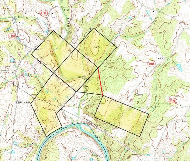

 I love driving home to Charlotte on the old two-lane Highways 64 and 49. It may be quicker to take I-85, but then again there’s the heavy traffic, pile-ups, and the void of anything beautiful. And, you must realize that the old way is changing fast. Lanes are being added every day and what were once small little towns are now extending their limits. So, let’s look back to the day and time when I was a college student in the late 70’s. What was it like back then to make the journey home for a weekend with family?
 Passing at 15mph around the
  flapping sound of overhead drive belts powered by a large 14 hp electric motor. There were swing saws and other woodworking equipment of the like I had never seen. Mr. Wright had flipped a 24” planer, transforming it into the widest jointer I’d ever seen. All I could think in seeing this was …Good God All Mighty! Mr. Wright was missing at least three fingers though his display and sales area were always filled with the finest woodworking.
 West of Asheboro, Hwy 49 splits off of Hwy 64 and heads southwest through the decaying mountain range called the Uwharries. Out in the middle of nowhere the road widens beautifully to four lanes through pastoral farmlands. The widened road is a stone’s throw from the town of Denton where is held the Annual Doyle Lawson Bluegrass Festival and Old Time Fly-In Threshers’ Reunion. On several occasions I timed my trips home to enjoy the summer festivities.
 mes were rough and my dad learned a lot about entrepreneurship as he didn’t sell enough to even pay his transportation. But, years later at NC State I had the chance to work at the University Crafts Center with student Marlow Gates whose story turned out much different.
 Just across the street and up a ways from Fine’s Broom Company an ancient stone wall appears out of the passing forest. Holding up an ancient roadbed from the ravages of a creek, the wall’s purpose is disguised by thicket and overgrowth as it disappears into the adjoining woods. Just as old 49 Hwy has been replaced by Interstate 85/40, there was once an even older road winding its way parallel to Hwy 49. It’s amazing what you’ll learn if only you let your eyes see things for the time they existed.
 antebellum hoop dresses, Barbie-like baby dolls were transformed into the perfect bedroom accent suited for the most tasteful southern lady. And yet, there was something odd about what I saw. Here was this lady only a generation or two out of slavery perpetuating the cast system from which her family had been freed. And yet, she appeared happy to be making her own money freely by the commands of her own hand. I often wanted to stop by and talk to the lady, to photograph her along with her wayside sales display. I can still see the sign on cardboard “Piller Dolls $10.00.” I’d love to carve a sculptural piece in memory of this old vision.
 Atop this hill crest crosses the old Concord Road and near the intersection stands

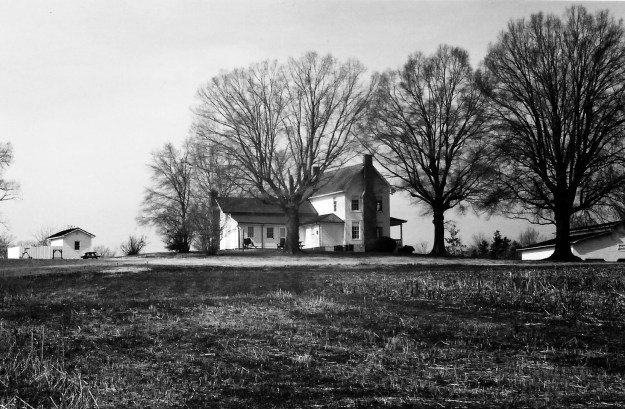
 Driving a bit further, I passed over Richardson Creek where I saw a stately old farm house standing near the intersection of Thomas Road. With miles to go and my day not yet done, I regretfully overlooked the need to photograph the old home. So, a big thank you goes out to Mr Yellow Google Man for capturing the image to the right.
 Before moving on a little needs to be said about the unit in which Calvin served. At Gettysburg but a few short feet from the base of a wall infamously known as the Angle stands a simple monument placed by the State of North Carolina. Marking the falling point of the furthest advance by any Confederate regiment engaged at Gettysburg, the pink granite stone locates the position where Calvin’ 26th Regiment fell in battle. It’s a story for historians and continues to be held up as a very important achievement though research shows the claim may have been made in error. I’ve had the chance to visit Gettysburg and in doing so put together
  Heading north on Hwy 742 from Calvin Thomas’ home place, I turned almost immediately right onto Thomas Road and soon-after to the left onto an unmarked gravel road known as Carpenter Road Extension. On the day of my trip I passed by a house deep in the woods doing all it could to hide from my sight. And, down the hill and around the slope of a hill was the final destination of my day’s drive.


 I’m not talking about some local parcel of land being here in North Carolina. For the first time to my knowledge, I can now get a free look at land anywhere I wish within the boundaries of the United States! You see, for many years as a backpacking enthusiast, scout master, and now as one who loves family history; I’ve always visited the Archdale Building here in Raleigh in preparation for my outdoor adventures. Topography maps purchased for around $10 give the best view of landscape including trails and elevation. And in terms of family history, they locate cemeteries as well as creeks and small paths. The maps are a must for those who need a close look at land and how it’s used.


