A TRIP TO GETTYSBURG

13With the exception of an occasional passing jogger, I was alone there in the misty Pennsylvania pre-dawn morning. Monuments to the dead rose above the hallowed fields as far as my eyes could see. And peacefully silent, I sat in tearful solitude near what was once the Union Headquarters. The morning glowed surreal as the changing tints of majestic purple washed over the landscape. Far across the fields laying before me, another monument made itself known. The white spot on the distant tree line acknowledged the State of Virginia, the Army of Northern Virginia and atop the large granite block was Robert E. Lee with his horse “Traveler.” Most if not all of the North Carolina troops serving at Gettysburg did so under the command of the Army of Northern Virginia.

Over 620,000 Americans died in the Civil War nearly equaling the combined number killed in all other armed conflicts. For every three men killed in battle, five died of disease. And at Gettysburg alone, over 51,000 were killed in just three days. Though a tragic waste of humanity, it was a necessary war and there was little option but for the south to lose. I can’t imagine this country if the outcome had turned out differently. And as for the State of North Carolina, we lost more men than any other state in the Confederacy and yet our men served valiantly while having the least to gain.

This slideshow requires JavaScript.

What was it like? What were the emotions running through the minds of my ancestral neighbors who made their way to Gettysburg for the pivotal battle? Found amongst the private collections at the North Carolina State Archives is the personal diary of Sergeant James E. Green. In the days leading up to Gettysburg, James wrote about the towns and of the people he passed. The unit moved north as the roar of cannons grew louder. And then, without warning, his regiment, CSA Co. I 53rd Reg. NC turned towards Gettysburg where it entered the fight. Take a moment to read the following pages from James Green’s diary:

21

Click here to read the diary

 In 1860 my g-grandfather’s older brother Hampton H. Thomas was enumerated as living in Monroe at the home of John Warwick, a shoemaker and emigrant from the state of Pennsylvania. Hampton enlisted 5 June 1861 in Co. B. 26th Reg. NC where he reached the rank of Sergeant.   I imagine the memory of John Warwick weighed on Hampton as he too made his way to Gettysburg.

“No Man Can Take Those Colors and Live”

battle-flag-of-the-26th-north

Battle Flag -26th Reg. NC

On 1 Jul 1863, the first day of Gettysburg, the 26th faced off with the 24th Michigan at Herbst’s woods. The 26th’s regimental colors were shot down 14 times with 588 out of the initial 843 troops being killed. The CSA 26th NC and USA 24th MI collectively lost more troops than any other units at Gettysburg …day one was over and it would not be their last.

21
On 3 Jul 1863, the 26th crossed the fields of Gettysburg in the Pettigrew-Trimble-Picket assault against the center of the Federal line on Cemetery Hill. In this epic struggle, the 26th  regiment’s colors would be shot down 8 more times with another 120 troops being killed. Planting its flag on the Federal works known as “The Angle,” the 26th NC may have advanced farther than any other Confederate unit. Or did they? There’s no doubt that the unit tragically lost more men than any other unit at Gettysburg. The monument at the foot of Cemetery Hill erected in 1986 by the State of North Carolina reads:

 Twenty-Sixth

North Carolina Regiment

Pettigrew’s Brigade Heth’s Division,

Hill’s Corps

Army of Northern Virginia

Although nearly destroyed during its successful attach against Meredith’s Iron Brigade on July 1, the Twenty-Sixth North Carolina Regiment joined in the Pettigrew-Pickett Charge on the afternoon of July 3. Advancing under solid shot hot, spherical case, canister, and musketry, the Regiment charged to within ten paces of the stone wall to their front.

The scene was described by an artilleryman of a Rhode Island battery: “. . .As a regiment of Pettigrew’s Brigade (the Twenty-Sixth North Carolina) was charging . . .and had almost reached the wall in front of us, Sergt. M. C. Onley cried out . . .’Fire that gun! Pull! Pull!’ the No. 4 obeyed orders and the gap made in that North Carolina regiment was simply terrible.” Under this galling fire, the Twenty-Sixth North Carolina was compelled to retire with the Brigade from this point to Seminary Ridge.”

“The men of the Twenty-Sixth Regiment would dress their colors in spite of the world”

Should we trust what’s written on the above monument provided by the State of North Carolina at one of our nation’s most important historical site? Are we certain the information is correct …is it historically accurate? From the history of Capt. William A. Arnold’s Company A of the 1st Rhode Island Light Artillery, much of the information on the 26th’s marker is founded in the writing of Thomas M. Aldrich. Looking more closely at how the battle unfolded, it appears the 26th NC may not have made it front and center to “the Angle,” but rather faced off with the 12th New Jersey and 1st Delaware a bit further to the north. If the monument is incorrect, why hasn’t the State of North Carolina changed it?

hampton

Regardless of how Gettysburg played out, the 26th Reg. NC served the cause valiantly. And as for Hampton H. Thomas, whatever became of him? According to his Combined Confederate Military file, Hampton H. Thomas lost a leg on 3 July 1863 after being captured at the battle of Gettysburg. Following the amputation of his right leg, Hampton was transferred to David’s Island, N.Y., to Fort Wood at Bledsoe’s Island, and then on Christmas eve of 1863, to the Point Lookout Prison in Maryland. Known as “Hell on Earth,” many died from typhoid and other diseases while confined at Point Lookout. Located on a spit of land surrounded by water on three sides, the huge number of prisoners confined in the small space quickly contaminated the limited water supply.


H201 Point Lookout, Maryland. Lithograph by E. Sachse & Co., 186

Point Lookout, MD

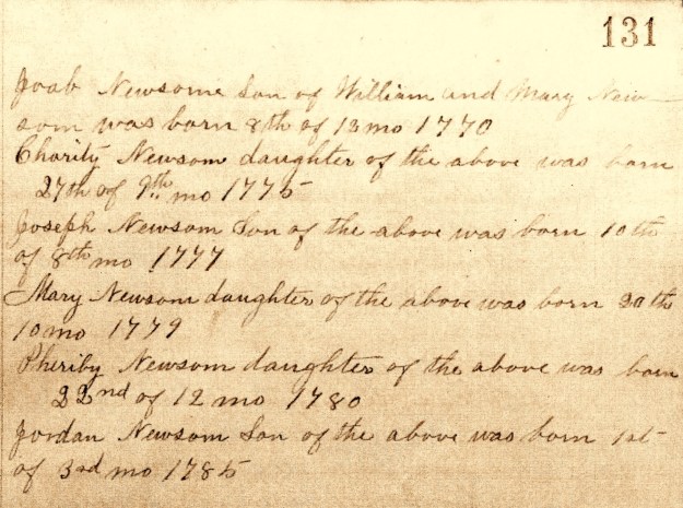
Hampton Thomas was eventually exchanged at City Point, Va where he stayed until 1865. Returning home to North Carolina, Hampton’s death is recorded in his grandfather Joseph Newsome’s bible. Though Joseph died in 1848, Hampton is listed in the bible as follows:

E - Copy

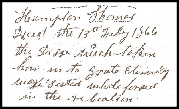
It’s very likely Hampton Thomas died of typhoid or from some other disease he contracted while in service at Gettysburg or imprisoned at Point Lookout. He’s likely named for a probable uncle Hampton Newsome who also served in the Civil War.  Hampton Newsome removed to TN where he lived out the remainder of his life.


A WARM DAY

DSC_6238_tonemapped.jpg

Here it is March 11 and I’m on my way to my favorite hangout at the corner of Jones and Blount streets. All the trees, shrubs and flowers are greening up for spring as temperatures again soar into the upper 70’s. Nature has changed or have we changed it? Regardless, the flowers and grand old oaks surrounding the nearby Executive Mansion react to the early change in season. And don’t they know? Don’t they know it’s not their time? The flowers will be killed as the nature of all things is playing an ugly trick. There will certainly be more killing frosts before winter submits to the warmth of summer. And yes, new growth and blooming flowers will be killed and next year’s landscape may change just a little. Few of us will notice the change. Only a hand full of us will look deeper into the struggles our plants must overcome to once again bring us flowers in the spring.

Seeking context for a post on Hampton Thomas,  a family member who served in the civil war, I visited archives today with the sole purpose of reading a diary written by James E Green. Finding the inspiration I needed, it hit me when I stepped back out to enjoy the day’s warmth. War happens and it takes our most young and treasured. Like the killing winds of winter, we can try to predict it, but much goes into timing. And like in our anticipation of each new spring’s blooming, we are often duped by the cruel whims of our own human nature.

MY QUAKER HERITAGE

1966_0816_002

Like a bow wave pushing forward in front of a boat, competing religious denominations moved through 18th century North Carolina staying just ahead of the King’s reach. Baptists, Quakers, Moravians, Lutherans and others, held to their own tenants of faith, but were ultimately governed by laws set forth by the crown. Escaping the tyranny of European kingdoms and principalities, some came to this land as individuals while collective groups came in contract with and even funded by England’s need to populate this new land. Did these newcomers find satisfaction and security in the “church state?” From civic duties to faith, the King had power over all. Ultimately resolved in revolution, was it right for such power to be based solely on one man’s spiritual interpretations? Escaping oppression to this land with promises of so much hope, matters of faith really were complex. Over the next few posts, I’ll take a little time to explore my Quakers roots and share how their story sets the stage both for and in conflict with who I am today.

Quakers believed in the inner light. This was the notion that God was a spiritual presence within each individual and could speak to all humans through the words and actions of anyone. 

The Society of Friends known as Quakers spread across the open landscape of North Carolina along two primary paths of migration. Out of New Jersey, Pennsylvania and Maryland, Quakers brought over by William Penn moved with Moravians and others along the old Indian path usurped and is now known as the Great Wagon Road. These Quakers settled in the piedmont, particularly in areas surrounding present day Greensboro. But much earlier out of southeast Virginia, others opened meetings down east in Perquimans County and at places like Rich Square in present day North Hampton County. These Quakers migrated westward up the Neuse River to places like Contentnea Creek Meeting in old Dobbs, now Wayne County. Slavery and events of the mid-1700’s made it impossible for Quakers to morally justify efforts aimed at further growth in North Carolina. Guided by a strong peace ethic, the Quakers removed themselves in mass to places like Ohio and Indiana.

It’s in this environment that I begin to write about the life and family of Joseph Newsome. He was born in Wayne County, the third child of William and Mary  Jordan Newsome. He is my third great grandparent. And as written in the records of Nahunta Monthly Meeting (from the earlier Contentnea Creek Meeting), Joseph Newsome was born 10 Eighth 1777. Note that Quakers did not use the pagan naming for months as we do today:

2 001

William Newsome was born about 1755 in Surry County VA, the son of Joel and Rebecca Dickenson Newsome. On 1770,1,20 William was received in membership to Rich Square Monthly Meeting in North Hampton County NC. There, he married Mary Jordan, the daughter of Joseph and Patience Ricks Jordan on 1770, 3,17. Joseph descended from Thomas Jordan, patriarch of what’s considered to be the most significant Quaker family in Virginia. And, closer to our immediate family, Mary Jordan’s brother Richard Jordan was a prominent Quaker Minister. He toured and preached throughout England and in his honor, a pattern of Staffordshire china was named for him. Richard lived out his latter life in New Jersey.  The image at the top of this post captures Richard’s home. ….and he is family!

My GGGG grandfather William Newsome’s request of marriage survives in Quaker Meeting records:

40642_301789-00033

As a child, our Joseph Newsome witnessed the rapid increase in the acceptance of slavery as a profitable practice by farmers used to increase productivity. The trend was met by Quaker sentiment growing in its voice to abolish slavery. And then enacted 13 Jul 1787 by our newly formed United States Congress, the Freedom Ordinance (formally An Ordinance for the Government of the Territory of the United States, North-West of the River Ohio) created the Northwest Territory situated beyond the Ohio River. Item 6, the final item of this important act reads:

0002

Free from slavery, the newly opened land was an answer to Quaker prayers. Beginning in the late 1790’s, a migration to Ohio and Indiana escalated after 1811 when peace with the Indians was realized following the Battle of Tippacanoe. By 1820, most Quakers in North Carolina had either been disowned for holding slaves against church doctrine or had removed from the state in protest of slavery. In witness from a Nov 1911 Quaker church information bulliten in observance of the Quaker migration, the following was said about a person who had relocated to Indiana from the Contentnea Creek Meeting in Wayne County NC:

“. . .was visited by an aged Quaker Minister, who stayed the night. The next morning, the minister got up early, and took a walk over the farm. When he returned, he told his host he had an impression from the lord, that it would be right for him to sell the farm and move to the territory of Indiana.”

_________________________________

And now back to the Newsome family. William Newsome was likely disowned from the Quaker Church prior to 1790 as in that year he is listed in the Wayne County census as owning one slave. Dated 17 April 1795, the marriage bond for our Joseph Newsome and Christian Barnes appears in county records. Christian is the daughter of Simon and Mary Barnes. The 1800 Wayne County census enumerates Joseph and family as owning one slave. And following the mass exodus of Quakers to Indiana, Wayne County was likely not the place it once was.  Land records show that Joseph and family removed to Anson County NC ca. 1817.

Now living beyond his Quaker upbringings, Joseph Newsome lived out the remainder of his life on the banks of Gourdvine Creek in now Union County NC. Did his childhood amongst Quakers have an impact on his life? Built on his surviving bible, future posts will delve deeper into his family and into some of their lives in our changing antebellum south.


THE JOSEPH NEWSOME BIBLE

C - Copy
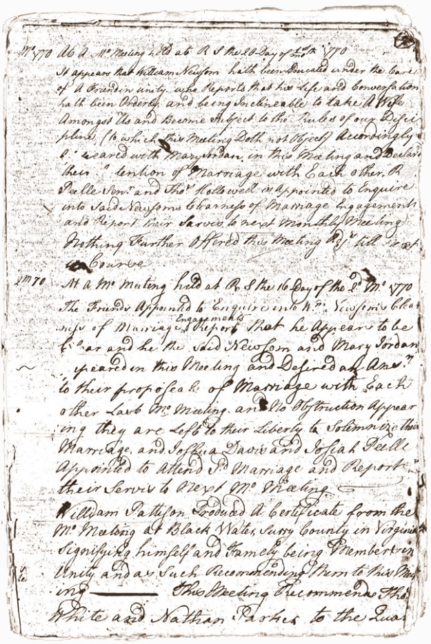
Joseph Newsome was likely born in what’s now Wayne County NC in 1775 at the start of the American Revolution. His ancestry is clearly traceable by land deeds to early 1600’s Jamestown VA and possibly earlier to Robert Newsome from the 1550’s Newsome Chapel in Lancashire England. Like many others, Joseph and members of his family moved south and west, settling on the hills along Gourdvine Creek in present day Union County NC. It was there where his daughter Ally Newsome married my ancestor David Thomas, the son of Ananias Thomas.

In the late 1990’s I was overwhelmed with joy to learn that Joseph Newsome’s bible survived and was safe in the hands of the family matriarch whose life, at that time, was beginning to fade. Befriending her grandchild online through Genforum, I was graciously given the following photocopies. As you can see, the technology of the day was not very good though that’s okay as the record held important bits of information including the life record for my great-great grandmother Alla/Ally Newsome Thomas. And looking back to Joseph Newsome, it’s hard to imagine his legacy. It’s big; statistically, from 3,000-6,000 people have walked this earth because of the life he perpetuated.

Now many years later, I’m wanting to tell Joseph’s story, to show off the bible record and to share what I’ve learned from its pages. Putting my newfound love of photography to work, I recently sought to create and distribute a more perfect copy of the bible record. But time moves forward and the old matriarch has since passed. And, in process, the bible’s whereabouts is not at this moment known. Hopefully it’s in good hands. Likely, the present owner is unaware of its importance and hopefully will someday bring it forward.

Moving on, I’ve spent the last few weeks watching evening TV while working to digitally clean the old record. I don’t know how I feel about that as I’ve surely made mistakes and altered what was written many many years prior. But hopefully, the record will increase understanding and encourage conversation on this wonderful family story. Here is the cleansed copy along with a typed version found in a Carolinas Genealogical Society Journal.

And as a note of its provenance, my copy of the bible record was lost many years ago in a computer crash. And, the Newsome descendant who helped me loaned out their copy and its whereabouts are no longer known. So I recently reached out to Newsome family historian Dave Johnston who had received a copy of the record about the same time as myself. Of note, Dave as a descendant is not from North Carolina, though he lived near the old Newsome home place in Wayne County while serving at Seymour Johnson Airforce Base.

Our family story survives because of good people who have kept the stories safe. Good record keeping is important as is the generosity of those who understand the importance for shared distribution of family records. A sincere thanks to Dave and to all who have made this post possible.


PT 3. THE DEEDS OF SAMUEL BONDS

IMG_20160119_193620227
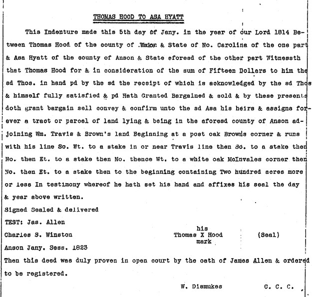
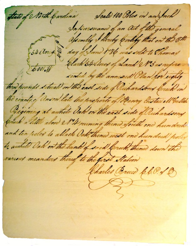
I really get excited studying land records as the story I’m wanting to tell changes with each new owner. Up to now I’ve centered on Adam Garmon, Joseph Garrott and Burdig Howell, and of their interests in a tract of land encompassing today’s crossing of 24/27 over Rocky River. A future owner moved from this, the lands of my mother’s ancestors and turned south to Anson County where his influence certainly impacted those living near my father’s ancestral family.

Sounds confusing, huh? Early on, I believed what I was seeing in this tract would end up being important. Through land records, I’ve been able to identify a possible church presence in Anson County that may predate recorded history. Before digging into this important post, let’s take one last look at the early title history for our tract of land along Rocky River at the crossing of Hwy 24/27.
mapt

Deed 6-53, Mecklenburg NC, 5 Feb 1771, prv’d 5 Feb 1771. Abner Nash and Justina his wife to Burdig Howell. Being 68 acres, the metes and bounds are: from a w. o. (on the south bank of Rocky River, running thence down the river) 144 to hic., north 66 west 114 to w. o., north 26 east 38 to pine, north 37 west 88 to hic. (on the river), then down the river to begin. Wit: Clement Nash.

Deed 6-128, Mecklenburg NC, 16 Dec 1771, prv’d Apr 1772. Burdig Howell to Peter Kizer.  Jurat: John Polk.
Deed 6-135, Mecklenburg NC, 1 Apr 1772, prv’d Apr 1772. Peter Kizer to Joseph Garrot. Jurat: ___ Polk.
Deed 7-385, Mecklenburg NC, 10 Jan 1774, prv’d (record lost). Joseph (J) and wife Suzana (x) Garrott to William Mitchell Wit: Peter (x) Curzine, Moses (x) Burleson.
Deed 10-475, Mecklenburg NC, 2 Feb 1779, prv’d _____, William Mitchell to Leonard Green. Wit: William Barker, Elizabeth Balch.
Deed 11-323, Mecklenburg NC, 1 Feb 1780, prv’d Apr 1780. Leonard (L) and wife Ann (x) Green to Samuel Bonds, being 68 acres. Wit: William Haynes, Jacob Self. Deed 13-779, Mecklenburg NC, 29 Jan 1789, prv’d Apr 1790. Samuel Bonds to Michael Garmon. Wit: Willi Potts, John McGuirt, Arch, White.

In 1779, William Mitchell sold this tract to Leonard Green who I firmly believe moved from what’s now southern Wake County where he was listed in county road orders. He must somehow be connected with the families of Richard Green and Gideon Green who settled in Anson and Montgomery Counties. As I’ll dedicate more time on Leonard Green at a later point, let’s move beyond the conveyance by Leonard and wife Ann to Samuel Bonds.

Samuel Bonds bought the tract at the crossing of Hwy 24/27 in 1780. A time when the Revolutionary War was just reaching the south, I suppose he lived there until selling the land in 1789. Not appearing in the 1790 Mecklenburg County census, Samuel shows up in Anson County where he received a land grant. Entered 15 Jul 1793, and issued 9 Jul 1794, Grant 5038 Anson NC was located on the south side of Richardson Creek where it adjoined lands of Layce. Shortly after, on 19 Jan 1795, Samuel Bonds purchased 54 acres on Richardson above No. 4 from Charles Calloway of Rockingham County NC (Deed C2-481 Anson NC). Witnesses were R. Galloway and Chappell Bonds. This land was originally owned by Henry Eustace McCulloh, a British land agent responsible for most of the development in western NC. Charles Galloway had acquired the tract from Thomas Clark who received it via the following Secretary of State grant of confiscated lands:

DSC_4851.tif.jpg

Samuel Bonds was on the move again as he’s enumerated in the 1800 Kershaw County SC census near sons Chappell and Seth Bonds. From the footnotes in Leah Towsend’s South Carolina Baptists 1760-1805 reads:

Gum Branch CB, 1796-1800, 1806; Rev. Samuel Bonds probably came to S.C. from N.C.; he had a survey in the fork of Sammy Swamp on Pretty Branch in 1784, but is not listed in S.C. in 1790; nothing is known of him after he left Lower Fork of Lynches Creek Church (Col. Rec. N.C., IV, 518; Plats, VIIq, 468

So, we now know Samuel Bonds was in SC as early as 1784 where church records list him as minister of Lynches Creek Lower Forks Baptist Church from 1795-1998. Per historical marker, and constituted in 1789, the church held early meetings at Lower Fork of Lynches Creek, Boggy Swamp and Witherinton´s Mill. By 1798, the church was located as mapped below and its name was later simplified to Gum Swamp Baptist Church. Of interest, Samuel Bonds proceeded Rev. James Hudson who was minister at Lower Lynches Creek in 1794. He was also listed as minister alongside Samuel Bonds in 1795. James is likely the son or close family member to Joachim Hudson who lived close to Samuel Bonds along Richardson Creek in Anson County NC.

And further information from the diary of Rev. Evan Pugh:

From May, 1789, to May, 1797, Mr. Pugh generally preached the first Sunday in the month at Black Creek. Rev. James Coleman, licensed preacher and messenger of the Cashaway-Mount Pleasant Church to the Charleston Association in 1795, was meantime working at Black Creek branch which was constituted a separate body on August 11, 1798, with eighteen members, by Rev. Messrs. David Cooper and Samuel Bonds. Black Creek immediately asked Mount Pleasant to give James Coleman a letter of dismissal, and on November 30, 1798, a presbytery consisting of Rev. Messrs. Samuel Bonds and David Cooper ordained him as pastor of the new church. Mr. Coleman, together with Charles Williams, secretary of the church, appeared at the Charleston Association meeting of 1799 and secured admission. Black Creek Church showed strong effects of revival.

There is no note of a meeting at Gum Branch until July 13, 1798, but the records are incomplete for the intervening year. At that time, bitter dissension had arisen in the church because Brother Samuel Bonds had brought an accusation of forging an order against the son of one of the members and had had a warrant made out against him after the charge was apparently disproved. This many members thought unchristian of their pastor. Brother William Witherington refused to commune, said he did not consider himself one of the church, and also declared that if the land had been his over which Rev. Mr. Bonds had opened a path to the meeting house he would “check him with the law.” Fellowship was withdrawn from Mr. Witherington and a presbytery consisting of James Coleman, John Sanders, Pigg and Waddill justified Mr. Bond’s conduct, but the church was dangerously near extinction due to this and a later breach. Mr. Bonds soon left.

Where did Samuel go from here? His sons are found later in Lee County GA. And printed in Tarorough NC, the following highlighted letter from his grandson appeared in a 1845 publication titled The Primitive Baptist:

primitivebaptist1011benn_0093

________________________________________

It’s time to bring this story to an end, so let’s conclude with a review of related records in North Carolina.

Firstly, knowing Samuel Bonds once lived just below Haynes Baptist meeting House, was he involved or likely even a minister at the church? Was that the start of his spiritual journey? Was he at all connected to Meadow Creek Primitive Baptist Church, an early church just across the river? Note that Persilar Bonds was mentioned in that church’s minutes:

1803 – Persilar Bonds was excluded for lying about potatoes.

Not the most flattering of entries, is there any possibility Persilar Bonds is related to Samuel? I dunno…

And moving to Anson County, we’ve discussed a deed for land once owned by British Land Agent Henry Eustace McCulloh. I’ve yet to physically locate the land though Samuel Bonds Grant 5038 Anson NC ties to a historic old church:

bonds

The above was issued to Samuel Bonds in 1794. Of all places, the tract clearly encompasses present day Jerusalem Primitive Baptist Church. Note I’m early on in my mapping project, so this could easily be off enough to where the old church may lay outside of the land bounds. Also, though there’s no record of Samuel Bonds later conveying the land, a search through deeds reveals an interesting title history:

Deed S-72 Anson NC, 7 Oct 1816, prv’d Jan 1822. William Curlee to Benjamin Oneal. Wit: George Hobbs, John (x) Wilkinson.
Deed U-28 Anson NC, 7 Oct 1821, prv’d Jan 1822. Benjamin Oneal Sr and Jr to Willie Baucom. Wit: Myrick Harward, Asa Baucom.
Deed Y-328 Anson NC, 10 May 1830, prv’d Sep 1833. Willie Baucom to Charles Austin. Wit: Myrick Harward, Wyatt Nance, Jas Broadway.

It’s believed that Jerusalem Primitive Baptist  was formed in the 1830’s. Is it possible that Samuel Bonds was involved briefly in a meeting in the same location that predates Jerusalem? Could something that began in his day and time have been instrumental in locating Jerusalem Primitive Baptist church where it stand today? I truly have no idea but have enjoyed the chase, of learning how the life and actions of this one person could cross county and state lines raising such possibilities.


PT. 2: JOSEPH GARROTT’S STAY IN MECKLENBURG

Wake County NC was cut from corners of Orange, Johnston and Cumberland counties in 1771. The town of Raleigh was not yet conceived as in 1788 the site was chosen specifically to become the state’s new capital. Raleigh wasn’t incorporated as such until 1792. There’s no real reason to tell you this other than during the time period 1772 and 1800 there seemed to be a steady migration from the area of Wake County to what’s now the areas between Anson and Cabarrus Counties NC. That, and as a teacher in 1980’s Wake County, I remember the name Garrott or Garrett as being common.

In early winter, on 17 Dec 1771, Burdig Howell sold his 68 acres encompassing present day Rocky River bridge to Peter Ciser/Kiser/Keiser (Deed 6-128, Mecklenburg NC). Peter sold the land to Joseph Garrott on 1 April 1772. Joseph didn’t hold on to it long as he and wife Susana sold the tract on 10 Jan 1774 to William Mitchell (Deed 7-385, Mecklenburg NC). Of special interest, William Mitchell owned land adjoining William Haynes, the likely namesake of Haynes Baptist Meeting House. William Haynes removed to Burke County in western North Carolina where he founded Bill’s Baptist Church near Chimney Rock in present day Lake Lure NC.

There’s no further record for Joseph Garrott in the area of Cabarrus or old Mecklenburg NC. There is however a family of that name that expanded out of Maryland along numerous routes through North Carolina. About the time Joseph sold his land in Mecklenburg NC a Joseph Garrott and others appear in Laurens County SC. I don’t have access to the best of records for SC though online, descendants indicate that family may have passed earlier through Pitt County NC. If so, and only as a what-if, early Cabarrus County would have made for a timely stopping point in their migration south.

Were there others from Cabarrus who moved to Laurens County SC?   Yes, apparently a David Templeton from Coddle Creek made the move. One of his family married the daughter of a person named Joseph Garrott in Laurens County.

And how about Adam Garmon? All Garmon histories line up a bunch of Michaels punctuated by a George early on. There must have been more branches than just those named Michael!

Dated 7 Apr 1779, Thomas Polk (Attorney for David Oliphant) sold land to Adam Garmon (Deed 7-84, Mecklenburg NC). Shaded in darker green below, this tract of 72 acres lies on the “waters of Rockie River neigh the Baptist Meeting House.” The deed is the definitive document used to identify Haynes Meeting House as an early church located just up the hill from the Rocky River bridge.

lowermap

Living on the land for less than a year, on 12 Sep 1779, Adam Garmon and wife sold the land around Haynes Meeting House to Henry Kent of Wake County (Deed 11-31, Mecklenburg NC). In a corresponding deed in Wake County, Henry Kent of now Mecklenburg sells his land on Utley Creek in Wake to Davie Straight. There’s no record of Henry selling his land in Cabarrus though he does appear in the 1800 Kershaw County SC census. Henry’s not alone as others also moved from Cabarrus and Anson to Kershaw SC. And note there are many in Anson County who once lived in the area of Utley Creek, Wake County.

Selling his land near the Baptist meeting house, Adam Garmon magically disappears and is no longer found in the area. There’s no known family ties or other information clearly locating his whereabouts. But just as quickly as he disappeared, another person named Adam Garmon shows up on Rabon Creek in Laurens County SC. And this Adam had a son named (surprise surprise) …Micheal, but of course!

Could Adam Garmon and Joseph Garrott have moved to Laurens County SC together or as part of the same migration?   I dunno though I’ve marked the following 1825 map of Laurens County with possible locations they settled upon. There’s a Garrott mill in the northeast corner on Copper Creek (marked by a red star). Further south and west we know Adam Garmon acquired land on Rabon’s Creek (marked by a blue star). The map is courtesy of the Library of Congress.

laurens

As my ancestor Jonah Love married Sally Garmon, the history of this family has always been important to me. And knowing of Adam, and of so little out there on him, it would be wonderful to identify him and his descendants as kin. To make this happen, I hope for DNA testing by members of both the Cabarrus County NC and Laurens County SC families. It’s easy to do and just requires action by those who are truly interested to know about their past.   Together we can do great things; let’s work together and tear down that wall!

teardown


PT. 1: THANK YOU BURDIG …whoever you are!

lowermap

lands of Burdig Howell – yellow

Dead Man’s Curve and Hell’s Half-Acre, and for many my age, there’s also fond memories of the bridge where Hwy 24/27 crosses Rocky River. I remember as a kid hanging my head out of the car to capture a glimpse of the flowing waters below. There was a large farmhouse, and we passed a single engine airplane and grass runway. My dad gauged the growing season as we drove by cornfields on the long descending curve. Raised in the city, this crossing over was an important part of my life. Not only did it carry me to my country cousins, it also introduced me to a whole other way of life.

In studying this area of southern Cabarrus County, I believe there’s a need to initiate a little online discussion into the lives of three particular settlers who lived oh so briefly near the present day Rocky River bridge. There’s Burdig Howell with lands not far from possible family member Joseph Howell. And in follow-up posts, I’d like to discuss Samuel Bonds who may have woven himself through the annals of Cabarrus and Anson before moving to SC. And finally, a person named Joseph Garrott just may provide new clues into a probable Garmon family member who escapes connection.

_______________________________________

We know of Joseph Howell and of his land near the mouth of Anderson Creek (located north of our Rocky River bridge). Joseph’s mother is buried at Haynes Baptist meeting house not far up the hill from the bridge. The church is long gone though the cemetery is marked by a cross in the green shaded tract above. It’s curious that early on, Joseph also acquired land very close to present day Bethel UMC.

About the same time, a little known person by the name of Burdig Howell purchased 68 acres from Abner Nash and wife Justina (Deed 6-53, Mecklenburg NC, 5 Feb 1771). The tract is situated along the Rocky River and takes in the crossing of Hwy 24/27 (see above shaded in yellow). It’s close to Joseph Howell’s land and just downhill from the ancient site of Haynes meeting house. Was Burdig kin to Joseph Howell?   And, if so …how?

Burdig Howell didn’t hold on to his land for long as he sold it to Peter Kizer late in the same year (Deed 6-128, Mecklenburg NC, 16 Dec 1771).

Scan_20160115 (2)

-land warrant for Charles Hart

Over a decade later, on 27 Oct 1782,a warrant  (Grant 3510 Mecklenburg NC) issued to Charles Hart identifies adjoining landowners as David Caigle and “Burdick Howell.” Located a little further north, Charles Hart’s land was situated on both sides of Rocky River just above the lands of Joseph Howell. Within two years after being warranted, the survey for the land no longer mentioned Burdick Howell.   Was Burdg still local; where did he go?


hagans

-survey for William Hagans

A year after being mentioned in Charles Hart’s land grant, Burdig shows up more than 20 miles to the south on Twelve Mile Creek. On 21 May 1773 (Grant 2632 Mecklenburg NC),  the survey for William Hagans describes a tract as being “on the waters of 12 mile creek including the improvement Burdick Howell now lives on.”

There’s no further mention of Burdig Howell. Working from the other end of his life story, descendants know him as Thomas Burdig Howell. Online discussions indicate that Burdig Howell removed from North Carolina and eventually settled around Greene and Hancock counties GA.

Later conveyances of the lands of Burdig Howell may add to the richness of early history while potentially opening the door to new family leads. The next post will cover land conveyances by Adam Garmon and Joseph Garrott.

A DISAPPEARING MAP ACT

Charlotte skyline

Charlotte skyline


Every time I drive home to Charlotte my visual impression is dominated by the expanding skyline. It’s cool! Charlotte, like most towns and cities, is growing at rapid pace. The landscape is quickly changing to a point I’m now loosing my way around. My phone is my map and my own memory is no longer needed. It’s deeply sad to see the old maps disregarded and even being destroyed as a result of the computer age.

As an arm chair history buff, the evolution of one type of map scares me. Looking at old land grants and deeds, I like to compare their old surveys to present day property tax maps. Finding some of the original boundaries, it’s a fabulous tool for connecting ancient landholdings to the modern world. But the end is in sight, the resource is disappearing and the blame is twofold.

Can you imagine using today’s county tax maps to find the original land grants as they were once located in what’s now downtown Charlotte? There’s no source for doing so as the degree of urbanization makes it impossible. But joy-joy …out in the rural areas old farms and forests are sometimes bounded by survey lines rooted in the original land grants. Highly valuable, these too are disappearing as urban sprawl invades the “country.” Just last week I heard folks talking about the town of Locust and how you’d better buy up land now as it was disappearing fast! hmmmm…

Along with the urbanization of rural lands, we’re also more efficient in how land is recorded. No longer do we have the old hard-copy books filled with plats and no longer do we have a hard copy county tax map. Plats are updated online as land is bought, sold and developed. It’s ever-changing nature destroys memory just as does an eraser on a chalk board. Does an annually published county tax map census exist? Maybe, but I question access and whether or not those in charge understand and support the public need to explore our past. GIS is a powerful tool, I just hope for a governmental act requiring an annual census of county tax maps.

Years ago my fear led me to visit local court houses in order to copy tax maps in the areas I research. Take a look, this may be of help to you!

2000 Tax Map for southern Cabarrus County

2005 Tax Map for southwest Stanly County

SOMETIMES YOU FIND WHAT YOU’RE NOT LOOKING FOR

Today we failed  to locate a cemetery near the old home place of Annis Nance Thomas.  Not sure what to think and what can be done at this point; Annie Lee and I walked it, Ms Emma verbally validated it, but I’m thinking it must be gone. But the day was not at all a wash!  I remembered seeing a cool old shack on Jerusalem Church Road and remember Annie Lee pointing out a field where once stood the home of Jacob and Hester Holly Thomas.  We drove to the area where we came across Tommy Turner working in his yard.  Tommy knew nothing of the old home place …I’m thinking it was a bit further down the road.  He did though show us the way to an ancient cemetery on his father Reece Turner’s land. It’s a place I had never heard about!

We walked our way to the back end of the property to a stand of trees on a hill that rises over either Little Watery or Flag Fork Branch. It’s been rainy to say the least and surprisingly …we made it with shoes in tact!  Here it is, take a look:

There are some uniquely beautiful old markers at the cemetery and I’m sure its location will play into future mapping plans.  I photographed what I saw and may need to go back to look more closely. Click here to see the stones.

It’s great to see such old places. We need more people like Mr Turner who care for these ancient sites. Their doing so enables us to rediscover the stories of our past. …Thank you Mr Turner!