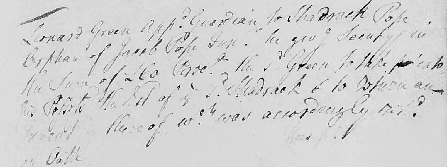
I recently shared a PowerPoint presentation with the Stanly County Genealogical Society on finding the intersection of McCulloch’s four great tracts. The location of a particular land grant used to make my point happened to be the ancestral homeplace of a fellow attending from his residence in Texas.
The talk reminded me that Zoom is a great new addition to genealogy as it draws together far-flung blood-kin and other folks like myself who share interests in a great many subjects, including specifics concerning counties where collective families once lived. We can now mix it up face-to-face. From the discussion and carrying this fellow researcher’s lineage one generation beyond his Herrin ancestor who lived at a location shown in my presentation, I realized how many families in Stanly County are rooted earlier in the region surrounding Wake County …the place where I now call home.
Background. This post centers on a 1799 petition signed by residents of Montgomery, now Stanly County, NC. The signees geographically represent a community in what is now northwest Stanly County. For me, I am curiously drawn to the realization that many of the signers were earlier found in Wake, Chatham, and Orange Counties when families were crossing the area in their slow-moving migration south and west.
 Now part of Durham County, as seen in the 1871 Nichols & Gorman map of Wake County, Township No. 7 was once home to numerous families ending up in Stanly County. Crabtree Creek, which appears on the eastern extent of the map (right), flows east across Wake County before joining the Neuse River near the town of Knightdale. The headwaters of Crabtree Creek are Brier Creek (yellow) and Stirrup Iron Creek (green), whose streams rise in the more recently developed land between Research Triangle Park and Falls Lake. Further west, beyond Crabtree Creek and a pronounced geological dividing ridge, the waters of Kit Creek (pink) meet up with Northeast Creek (blue) before making their way to the mighty Cape Fear River in Chatham County. It amazes me that Kit and Stirrup Iron Creek are only a mile apart in old Wake County, and yet, their waters are separated by more than a hundred miles of coastline upon reaching the Atlantic Ocean. It’s in this mapped area, near Morrisville, where much in this post is rooted.
However, I cannot rightfully confine ALL the beginnings I will discuss within the small area outlined in the previous paragraph. Some migrated through northern tier counties or even directly from Virginia, while others moved about, maybe initially arriving at the Upper Neuse River in their spread west from places like Bertie, Edgecombe, and Franklin Counties. And for some reason I do not yet understand, an evolving trifecta of sorts introduced a packing of settlers to a third location, along Wake county’s southern border into Chatham County. The waters of White Oak and Buckhorn Creeks were most enticing in that system, which emptied into the Cape Fear. And as I learned from a friend, the town of Holly Springs in that area does not owe its name to a silly tree; instead, the community is clearly named for the Holland family, whom I will brief in this post. One studying family passing through these places must look beyond any mindset built on locating their family homeplace to one specific county. The following offers bits of thought on families who came through the region who later signed the 1799 petition in Montgomery County. Note that these are not my families; my understanding of their genealogies may be written in error.
The Herrin Family. Some online say that Hezekiah in Stanly County is the son of Alexander Herrin found earlier in Chatham County. I believe Hezekiah Herrin’s father is Edward, who initially is found in Wake County. Once again, I’ve got to be careful not to overemphasize the importance of one county over the other as it appears the family lived near the Wake and Chatham County line, which area was all part of Orange County before 1771.
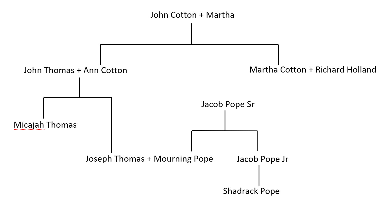
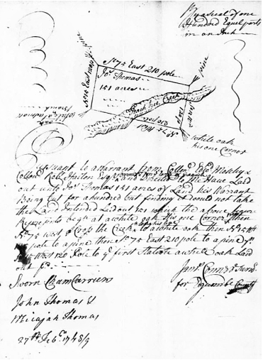
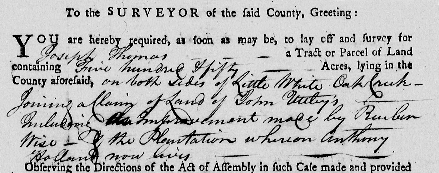
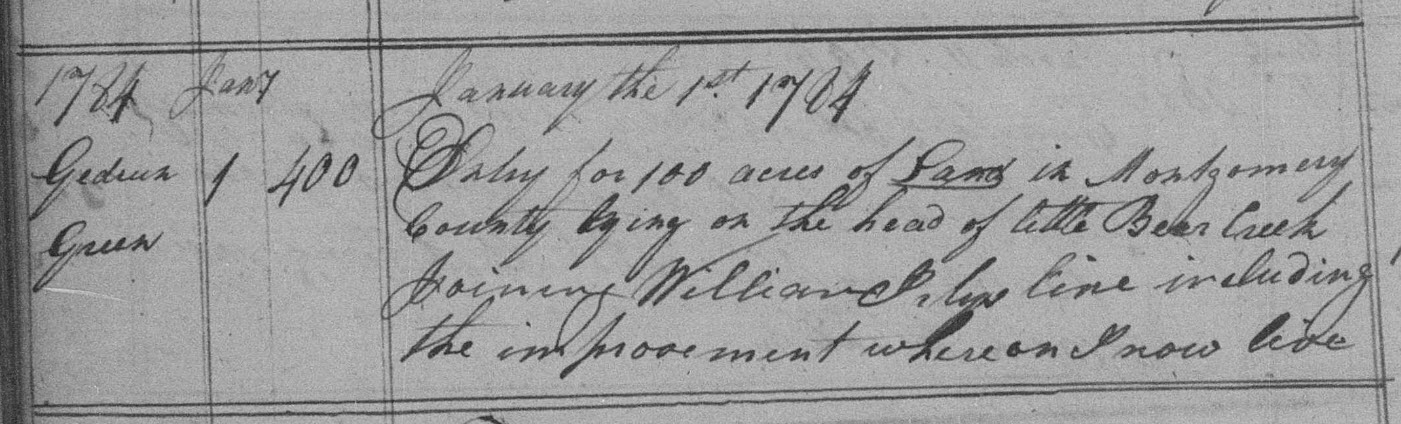
In 1780 Edward was issued 200 acres (313, Wake) on Little Beaver Creek, which rises in the present-day community of New Hill (in southwest Wake County) before flowing west to Jordan Lake in Chatham County. The surveyor’s order states that Edward’s land was located “on both sides of Little Beaver Creek above Anthony Holland’s Path.” Furthermore, located a few tracts south, my Y-DNA cousin, Joseph Thomas, received 550 acres on Little White Oak Creek, “including improvements made by Reuben Wise – the plantation wheron Anthony Holland now lives.”
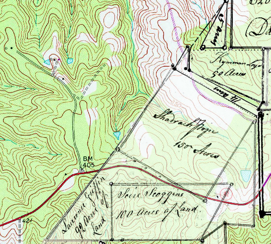
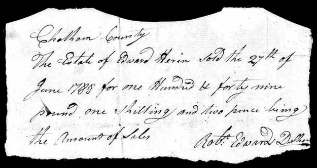
Two years later, in 1782, Edward Herrin was found ten miles to the north, where he received 150 acres (784, Wake) on Kit Creek near present-day Morrisville. Edward’s granted land adjoined Moses Herron’s, with Edward Herron Junior and Owen Herron serving as survey chain carriers. Ultimately, the Herrin family coalesced briefly to the north on the waters of Marks and branches of Kit Creek along the line between Wake and the extreme northeast corner of Chatham County. And then, in 1788, loose estate papers in neighboring Chatham County give notice of Edward Herrin’s Death:
Moving West. Edward Herrin [Jr.], son of the deceased above, received in 1799 a land grant in now Stanly County (1214, Montgomery) on the Bee Branch of Pole Bridge Creek. Younger Waldrop and Thomas Motley served as chain carriers. Edward also entered a 200-acre tract though the grant was never issued as signified by the file number beginning with a zero (05, Montgomery). Younger Waldrope and Edward’s brother Owen Herrin served as chain carriers for that survey. In Wake County, Owen Waldrop served likewise, which leads one to surmise that following the Death of Edward Herrin Senior in Chatham County, his sons Owen and Edward Jr moved west to Montgomery County.
They signed a petition. Initially of unforeseen importance for those arriving in Montgomery County, back in the vicinity of southern Wake County and located but a short distance south of Edward Herrin Sr’s granted land on Little Beaver Creek, the town of Haywood was founded with visions of becoming a major inland seaport in addition to being both North Carolina’s permanent seat of government as well as the home of the University of North Carolina. Located just southwest of the Chatham County line where today US Hwy 1 passes over the fork of the Haw and Deep Rivers, the town of Haywood was initiated by our state’s constitution though both measures failed by a vote of one with Chapel Hill becoming the home of UNC and Raleigh, our state’s capital. In this reality, the Revolutionary War caused a tremendous headache as much-needed funding to build and operate the University in Chapel Hill had been drained.
When things go wrong in a community, concerned people gather to air their complaints through written petitions. That very thing happened in 1799, in what is now Stanly County, after the state confiscated lands once owned by opposing revolutionary Tories to fund UNC. Much of Montgomery County happened to be settled from an early Tory business venture. Though the idea was good in principle, a major problem arose as much of the ill-fated lands had already been broken up by conveyances to those arriving in Montgomery from Wake & c. and by way of earlier arrivals. Imagine if it were you who settled on land once owned by Tories only to have a state bureaucrat tell you it was no longer yours and you must be gone:
“About three years ago, Adley Osborn, attorney for the Trustees of the University, intimated to us, that our improved Plantations and all vacant land lying in Great Tract No. 6 first granted to Murry and Crimble, and escheated, were given as a Donation to the University & wanted to compromise with us for it. But we been entirely uninformed of any thing, concerning this matter, and thinking ourselves safe enough by our state, grants, refused firmly to enter into any compromise and ever since we been let alone, till now lately said Attorney Osborn attempted the second claim for our lands by a threatening advertisement to which we are unwilling to agree.”
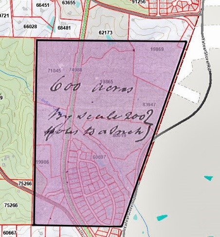
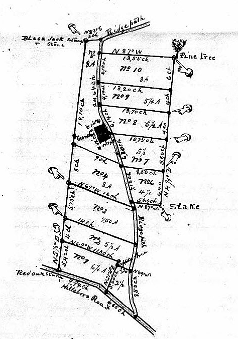
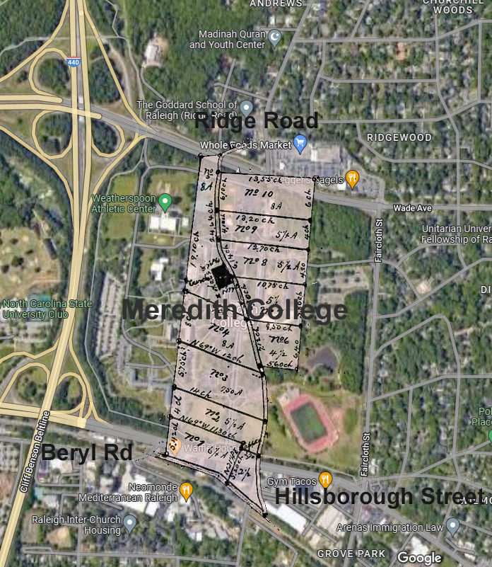
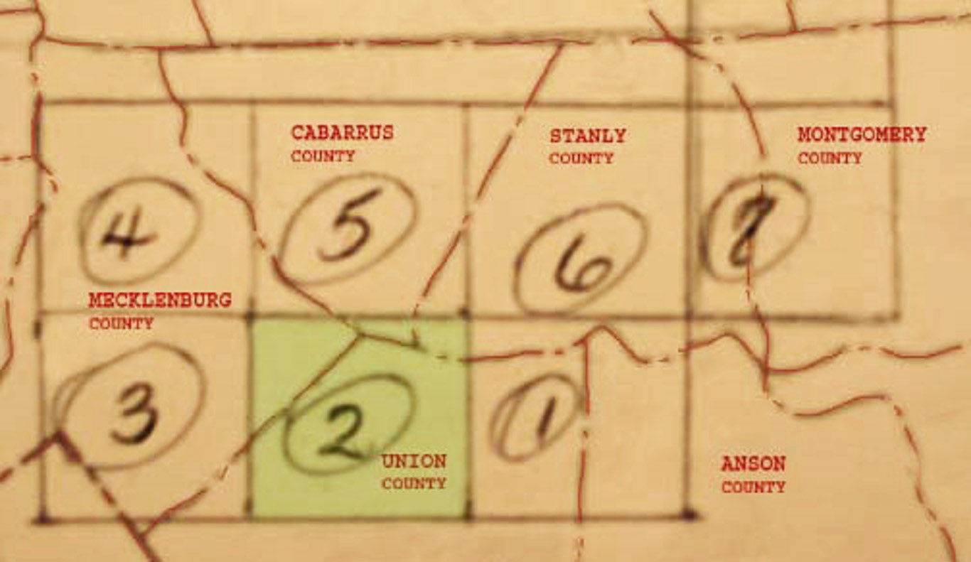
The aforementioned 100,000-acre Great Tract # 6 was broken down into eight subsections as appears below:
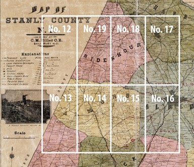
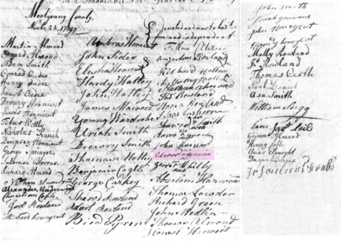
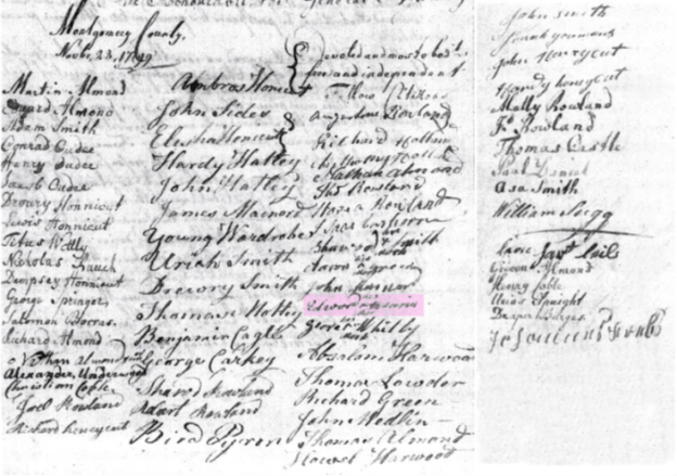
That’s a huge chunk of real estate and much impacted by our new government’s scheme to build a college were the many who had recently settled in the remote reaches of Montgomery County …coincidentally being people having removed from the area where the construction of UNC was initially proposed! The signature list below of “fellow citizens” is from the 1799 petition, and concerning its importance, I encourage folks to read my earlier article, UNC – The Compromise for Bear Creek.
Believing the 1799 petition to be a good starting point, this post, broken down sub-sectionally by surname, offers random thoughts on some of the settlers living in northwest Stanly County. Note that the work is incomplete, a concern I’d love to hear from families not included. The families further represent those who gathered to formulate a petition after being contacted by the state’s attorney to clear land titles before granting the homesteads of its citizenry anew.
The Harwood/Harward Family. Penned in 1769 Edgecombe County, Joseph Harwood named in his last will and testament an enslaved person named Jenny whom he bequeathed to grandson Howell Harwood who was mentioned among stipulations concerning other grandsons. This elder Joseph Harwood also mentioned his sons Absalom and Joseph [Junior] Harwood:
Item I Bequeath to my Grandson Howell Harwood My Negroe Wench Jenny But is not to have possession of her before his father’s Death and if he should Die before his father I will her to my grandson Jesse Harwood.
 Reeling forward more than a hundred years to the 1870 Stanly County mortality census, a person named Howell Harwood is enumerated as being 103 years old at the time of his Sep 1869 death. It’s easy to suppose this Howell Harwood to be the same as he who is mentioned in the 1769 will; however, the extreme age is in no way supported by earlier census data (1800-1860) though a person of the same name appears as born a little later, in the 1780s. It appears Howell Harwood mentioned in the will is the son of Joseph Harwood [Jr.] though the given name was also used in the family of the said Joseph (Jr.’s) brother Absalom.
Absalom Harwood sold his Edgecombe County holdings (D-333, Edgecombe) in 1770 as did his brother Joseph [Jr.] (D-275, Edgecombe). Online genealogies show that Joseph Harwood [Jr] died ca. 1784 though a quick look into his real-estate title history has not revealed any supporting details. However, in 1778, Joseph’s brother Absalom Harwood entered a 600-acre grant for land (275, Chatham) on the Wake/Chatham County line. Then, a year later, Absalom entered an additional 650 acres (657, Wake) under “Harrod.” Clearly located nearby and crossing the county line, this second tract west of present-day Morrisville was situated on Indian Branch of Newhope Creek, which adjoined the land of “William Harrod.”
Also occurring in 1778, the same year Absalom entered land crossing the Wake and Chatham County line, Howell Harrod entered 282 nearby acres (1754, Orange) on the waters of Newhope Creek. Some show that Howell died locally though I believe he later moved west across the Yadkin River to Montgomery County, North Carolina, with his Uncle Absalom Harwood. There, both Absalom and Howell Harwood signed the 1799 petition concerning lands sought after for the benefit of UNC. I believe Howell eventually took off for Tennessee as he appears records there acquiring land in Stewart County. Supporting this idea, Howell’s entry in the entry book is close to others known to be rooted earlier in Montgomery County, North Carolina.
The Herrin Family. Edward Herrin (shaded purple) signed the 1799 petition, as did Anthony Holland, whose affirmation appears seven signatures ahead of Edward. See them? If nothing else, the signatures prove that all the signers were settled in the same impacted area within the county as of 1799. Furthermore, I believe the signature for Anthony Holland may represent the same person who lived earlier on land in Wake County, granted to Joseph Thomas in 1780. This Anthony is the person whose name was used for the path that ran below Edward Herrin’s land. Is this also the same Anthony Holland whose history goes back to Edgecombe and earlier to Bertie/Chowan Counties as discussed in my earlier posts? I think so, and likewise, for most who signed the document above, I believe their exact identities have not easily transferred across time and space during their movement west from Edgecombe and other points to the east.
We can easily imagine kinship and make declarations, though proving specific family relations becomes an arduous task fraught with risks of genetic conflation. And similarly, as for Edward Herrin, my opportunity to meet his living descendant from Texas via Zoom awakened in me the need for better understanding as we trace this community’s movement across the Yadkin into old Montgomery County.
 The Wardrobe/Waldrop and Almond Families. Phonetically the oddest of signatures in the 1799 petition is that of Younger Wardrobe (Waldrop) who appears in Montgomery County in 1790 and 1800. However, in ca. 1790, Younger was also in Wake County, where he is identified in estate documentation as purchasing from his deceased father’s estate. The son of James Waldrop, Younger’s family lived along Lick Branch and Brier Creek within the Northeast Creek watershed. As already discussed, Northeast Creek, a branch of Newhope Creek, rises west of the present-day Durham/Wake County line before emptying into Jordan Lake in Chatham County.
Earlier, in 1780, James Wardrope’s survey for 200 acres (74, Wake) on Lick Branch in then Wake County mentions neighbors Richard and Nathan Almond, who also moved west as they appear in the 1799 Montgomery County petition. There is no recorded record of Younger Wardrop receiving granted land in Montgomery County, and any record of deeded land by Younger would have been destroyed in 1843 when arsonist Elijah Spencer burned the Montgomery Courthouse: “the loss of all the wills, deeds, dockets, bonds, and settlements of estates, etc., must be a source of incalculable and irreparable evil!” Despite the significant loss of documentation, two post-Montgomery Stanly County deeds mention Younger Wardrobe in the context of a stream where he likely lived:
-
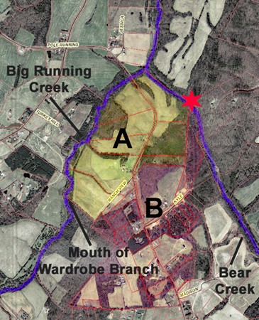
- Peter Cauble to John J. Cauble, (Deed 1-190, Stanly). Situated in the fork of two creeks, survey metes and bounds begin on the northeast corner of this tract (shaded yellow) at the red star on bank of Big Bear Creek. The survey’s first line runs northwest to the mouth of Big Running Creek and then up that creek “to the mouth of Younger Hardroup’s Spring Branch then up the various courses of said Branch about 4 chains” or 264 feet which is less than the length of a football field.
- Eli R. Herrin to M. F. Yorke, (21-364, Stanly), being 225 acres per deed of trust involving A. G. Freeman. Situated west of Big Bear Creek, this tract nicely abuts the abovementioned land. The northern end of this land (pink) adjoined Rowland lands while the southern end joined lands belonging to ——— Motley and John Eudy Jr.
The above Peter Cauble is the son of petition signee Christian Coble who received nearby granted land (1043, Montgomery) in 1797. Situated a few miles to the east, the order to survey describes the land as “containing 100 acres on Bigg Bear Creek of both sides including the improvement that formerly belonged to Barton Daniel at which the same is my property purch’d of Paul Daniel.” I think this land was near the early home of Solomon Burris, who lived for a while northeast of present-day Pleasant Grove Baptist Church on Ramsey Branch. Furthermore, adjoining the lands of Christopher Coble happens to be petition signee Ambrose Honeycutt whose failed land entry (01, Montgomery) was also situated on Ramsey’s Branch of Bear Creek.
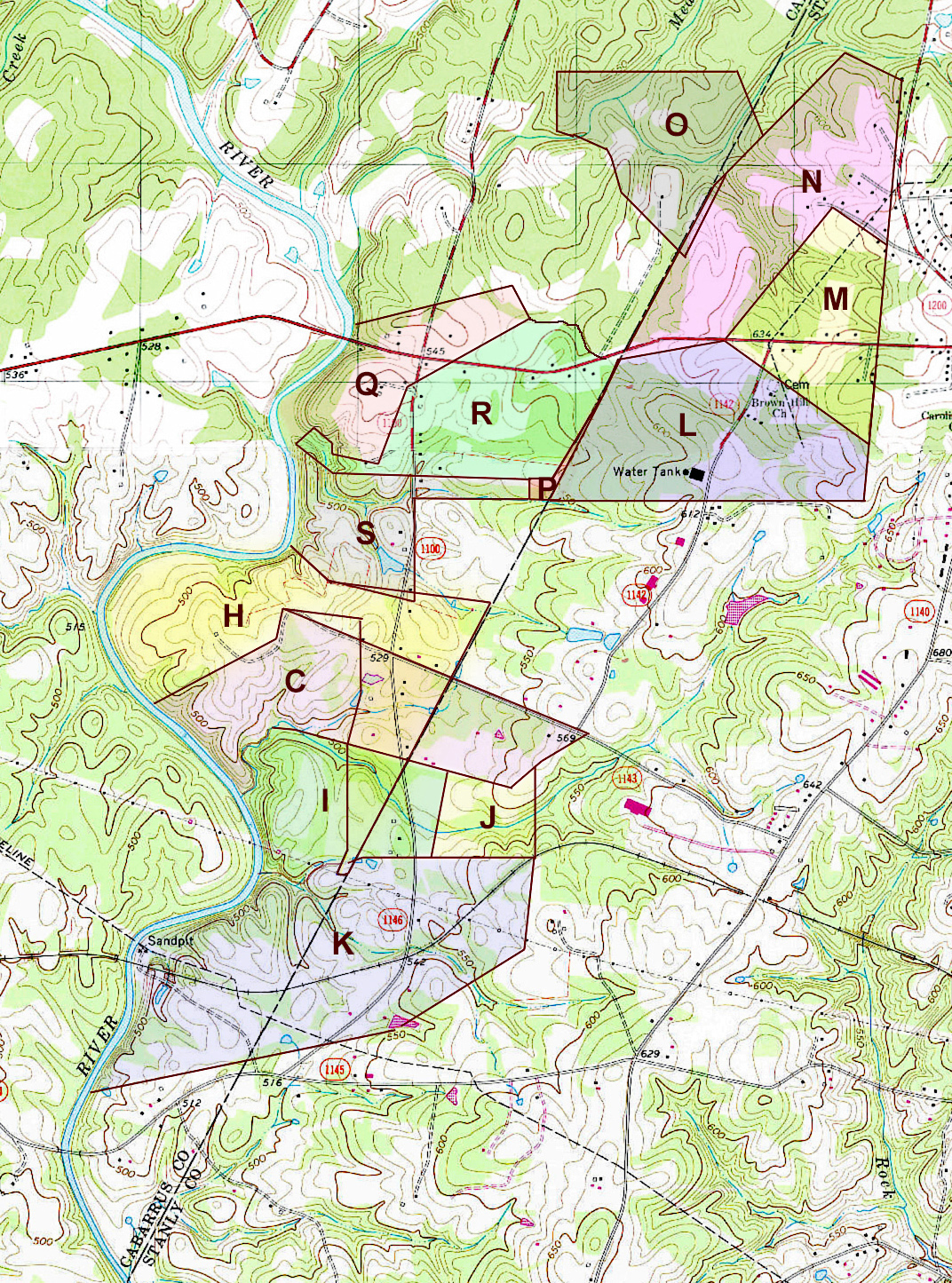
Back to Younger Wardrobe, the stream bearing his name provides an excellent memory though I wanted more. I was seeking to understand the early community better while platting land grants and deeds in the area; original ownership for the small waterway was revealed through happenchance alone. Platting tracts A, B, and C (below) and overlaying them atop the snazzy new Stanly County GIS map offered a reverse perspective from one of tracing today’s record back in time. The three deeded tracts, as seen below, are:
-
- (9-489 Stanly) George Blackwelder to J. F. Herrin.
- (1-259, Stanly) Hezekiah Herron to Nathan T. Starnes
- (26-327, Stanly) Jonah M. Lambert to E. M Hatley …which land adjoined the Fayetteville Road to the south.
At the same time, I also digitally puzzled together four land grant surveys (in black below) whose originals are housed at the State Archives of North Carolina. Only in visually seeing the images side-by-side was I able to realize that the deeded plats fit like a glove against Thomas Motley’s 225-acre grant (1583, Montgomery). More importantly, the process enabled me to reference and locate many other tracts, as the ancient metes and bounds are perfectly visible today on GIS.
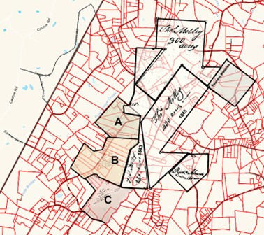
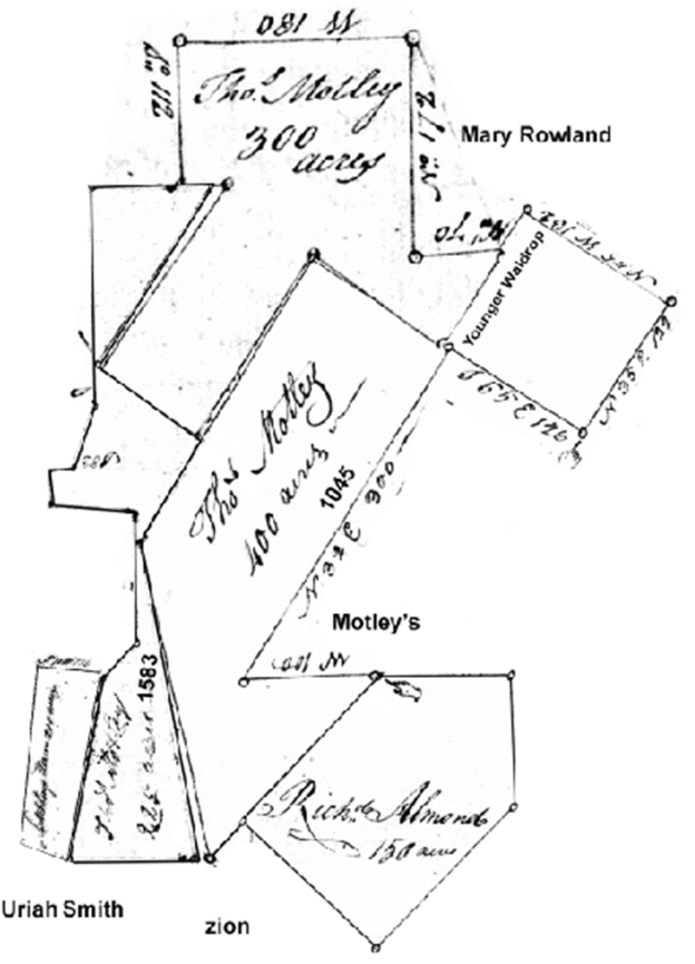
So, I love nothing more than sharing process and think the above is really cool, though where is Younger Wardrobe? Note that the survey for Thomas Motley’s 400-acre tract (1045, Montgomery) (above) indicates the land includes “Younger Wardrobe’s improvement.” And nested beside the 400-acre tract, Thomas’ 300-acre tract (1149, Montgomery) is said in its survey to join Younger Wardrobe’s land in an area within the shaded diamond-shaped section of the 400-acre tract. See it? At some point, Younger owned or lived on a piece of Thomas Motley’s land which, when overlaid atop the GIS map, happens to be the same piece of land whereupon Waldrop’s Branch flows in a much differently shaped tract today. I love it when land is proven across time!
Younger Waldrop did not remain long in old Montgomery County as he was in Kentucky by 1806, where he applied for a revolutionary war pension in Hart County.
The Daniel Family. A mystery I’d like to resolve; how does the Daniel family in early Montgomery County connect to those living on the Cape Fear in Chatham County? In 1793, my ancestor, Solomon Burris, received a grant for 200 acres on Ramsey’s Branch on “the waters of Big Bear Creek …including Barton Daniels’ Improvement.” Some histories online state that Barton’s full name is “Barton Peter Daniel” though available documentation leaves one thinking this family’s history may be influenced by genetic conflation.
Living near Ramsey Branch, on the next stream to the west, Paul Daniel received a land grant for 130 acres (513, Montgomery) on Stony Run, at which time the chain carriers were Edward Almond and Luke Rigsby. And then, in 1798, Paul Daniel received another 100 acres (1068, Montgomery) upstream on “both sides of Big Bear Creek including the plantation I now live on as I purchased of Nathan Almond.” Chain carriers for this grant were William Ramsey and Drury Rigsby.
Names mentioned in grants offer an essential sense of community, and in this case, I believe Paul and Barton Daniel should be seen as closely related. In proof of my point, rather than found in documentation recorded under the name of Daniel, remember above that Christopher Coble’s grant mentioned an “improvement that formerly belonged to Barton Daniel at which the same is my property purch’d of Paul Daniel.” It appears the land originally belonged to Barton Daniel before passing through Paul Daniel and being later sold to Christopher Daniel, who received the land anew in the form of a state land grant. Not only were these people friends, but the wording also gives the strongest of hints that Paul and Barton are likely kin.
Upon moving to western North Carolina with others, Charles Cagle deeded land (deed 12-498, Buncombe) in 1819 to Job Self on the fork of Mills River, where Francis Self now lives. Crazy cool, all those above once lived in Montgomery where I believe their families maternally crossed paths in ways we do not fully realize …and note that the deed was witnessed by William Daniel, who the family believes to be the son of Paul Daniel. Histories online state that William Daniel married Job Self’s daughter Sarah before relocating to Georgia.
Looking at census records, both Paul and Barton Daniel are enumerated in the 1784-1787 Montgomery County list. However, in 1790, Paul disappeared from Montgomery County with only Barton remaining. What happened to Paul and yet, in neighboring Rowan County a person named Paul Daniel suddenly appears in 1790 alongside Peter Daniel and others of the same surname:
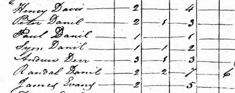
Is Paul Daniel in Rowan the same as he who was earlier living in Montgomery? If not, what happened to Paul, and who are the others per the Rowan County census? I am trying my best to connect the Daniel clan in Montgomery County to Isham, Jesse, and Littleton Daniel, who I know lived upon the waters of Shattuck’s Creek along the Cape Fear River in Chatham, …though the given names of Sion and Randal above are found more distantly in Halifax County. Furthermore, mentioning William Ramsey alongside the Daniel men in Montgomery County makes me wonder if William somehow ties back to Ambrose Ramsey, who operated a Chatham County mill famously crossed by Lord Cornwallis during his retreat to Wilmington. To that end, some say that William Ramsey, also found in Buncombe County, is indeed the son of Ambrose. If that is true, he must also be the same William Ramsey whose name was given to a stream my ancestor lived on in Montgomery County. Further yet, and as will be shown, I believe the Rigsby men who served as chain carriers in Montgomery also harken back to Chatham County but for now, let’s take a closer look at the Daniel family in Rowan County.
Per the marriage bond, Paul Daniel married Elizabeth Smith in 1790 in Rowan County. Then, in 1795, William Smith of Rowan County wrote his last will and testament mentioning “my three daughters Sarah wife of Joseph Moore, Kiziah wife of Stephen Orsborn, and Elizabeth wife of Paul Daniel.” Not only do I see Paul and his widow Elizabeth, but back in Chatham County, a person named Stephen Osborne lived on Shattock’s Creek beside the family of Littleton Daniel. I now wonder if I am seeing some connection to those in Rowan.
Also enumerated in Rowan is Peter Daniel in 1790, who died soon after as his 1791 last will and testament probated in Rowan County mentions wife Winniford and all his children. However, he bequeaths explicitly to loving son Paul “forty-three acres of land that was lately surveyed for Jno. Henkle potter being to the No. west of my lot of land joining William Scoles line and Moses Perkins.”
Making it difficult for me to immediately jump to these people as being the same family living in Montgomery County, Peter’s land in old Rowan County is situated on the Brushy Fork within the historically significant Abbot’s Creek Baptist Settlement located some 45 miles away from the Daniel land in old Montgomery County. This other land is situated north of present-day Lexington, North Carolina. About that land, earlier, in 1787, Paul’s father, Peter Daniel, purchased the above land on Brushy Fork (deed 11-752, Rowan) from Luke White, with Paul Daniel witnessing the transaction. Coincidentally, Luke White is believed to go back to early Bertie County, where records connect the White family to my Solomon Burris family beginnings. Note that this Peter’s son Paul Daniel later sold his inheritance (14-201, Rowan) in 1795, when the transaction was witnessed by West and Sion Daniel, which happen to be other names mentioned in period Halifax County deeds.
Back to Montgomery County and added to the mix is Benjamin Woodson Daniel, who received several grants on Long Creek, which Big Bear Creek joins downstream nearer to Rocky River. From his revolutionary war pension request, Benjamin W. Daniel stated he was born in Wake County and, after the War ended:
“he was living in Rowan County North Carolina, from there I moved to Rutherford County in the state of Tennessee and after a 12 months residence and there I moved to where I now live in the Stewart County in the State of Tennessee where I have lived 13 or 14 year.”
Indeed, Benjamin W. Daniel lived in Rowan as he was granted land (3921, Rowan) at Bald Mountain on the Yadkin River near the present-day crossroads community called Newsome.
Concerning the Daniel family, I ask folks to take my writing as if a grain of salt because cyphering beyond mere mentions of possibility requires much more effort than can be offered in this brief overview. But for now, know that ties, potential ties, or coincidences are not confined to Piedmont, NC. It is known from his revolutionary war pension request that Benjamin Woodson Daniel eventually moved to Stewart County, Tennessee where his life record continues to tell its story. Stewart happened to be in the Military region set aside for Revolutionary War land grant bounties to award soldiers with land in compensation for their services during the revolution. Also found in early Stewart County are Sion, David, William, “Barton” and others of the Daniel surname. As for Rowan County Peter’s son Paul, he may have ended up in Morgan County, Tennessee, while I believe less is known of the older Paul who acquired land in Montgomery County …unless he is the son of said Peter. Paul’s whereabouts remain unknown to me though his son William ended up in Georgia.
Of importance to me at this point are the often-unsung stories of chain carriers, including those identified in Paul Daniel’s land grants in Montgomery County. Sometimes documented scantily in a location, one must also consider hints hidden in the record of neighbors and acquaintances. As for William Ramsey, he may be kin to Ambrose Ramsey, who operated a mill on the Deep River in eastern Chatham County. And, as for Drury Rigsby, who served as chain carrier for the grant issued to Paul Daniel, I believe he is likely the same person who requested a revolutionary war pension in Kentucky. When asked where he was born and where he lived following the War, Drury Rigsby responded:
“I was born in Fauquier County on the Rappahannock River Virginia on the 15th day of January 1745.” I lived “in Rowan County North Carolina and also in Chatham County North Carolina, I moved from Chatham to Wilkes County North Carolina and from that County, to this (Lawrence Kentucky) where I now reside.”
With never a mention of Montgomery County, Drury spoke of Rowan which county line was but a few miles north of where he held the chains for Paul Daniel’s survey. Drury was not alone in Montgomery County as his likely brothers Luke and Thomas Rigsby also served as chain carriers for grants issued to others who once lived in Chatham, Wake, and Orange Counties. Furthermore, Drury Rigsby is not readily found in Wilkes County in western North Carolina as indicated in his Revolutionary War claim though his brother Thomas is enumerated in the 1800 Buncombe County census where he received a land grant (365, Buncombe) in which the chain carrier was none other than Richard Almond who had likely been his neighbor in Wake and Montgomery Counties. It appears that Thomas Rigsby eventually made it to Wilkes County by 1820.
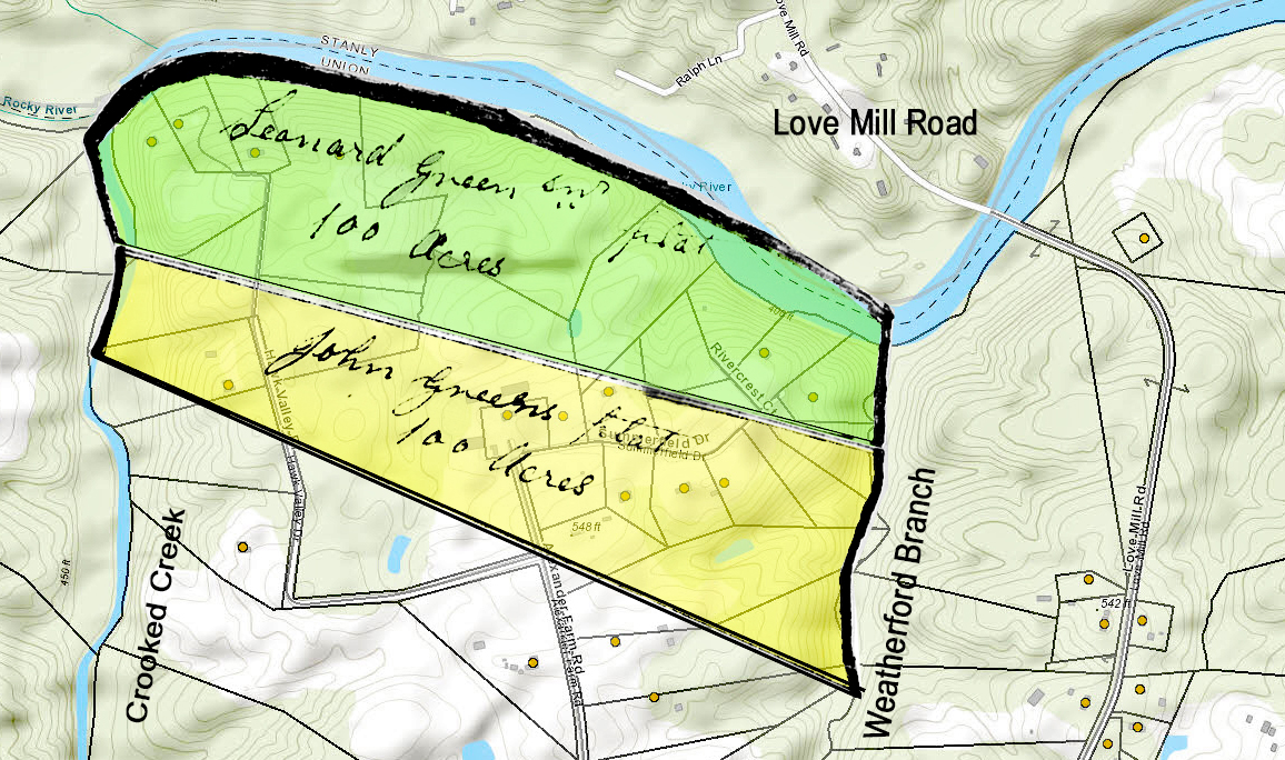
The Motley and Maynard Families. Thomas Motley married Keziah Barbee on 28 Jun 1784 in Wake County. One year following the marriage, Thomas Motley purchased from Richard Almond (deed F-28, Wake) a 100-acre portion of granted land (686, Wake) situated on the east side of Gibson Creek, a branch of Northeast Creek. This tract is in a portion of Wake that became Durham County near Kitt and Stirrup Iron Creeks. Thomas Motley and his family moved to Montgomery County, where his sizeable acreage was on the waters of Big Running and Pole Bridge Creeks near the present-day Cabarrus County line. Also making their way to Montgomery County, the family of John Barbee settled to the south, on Meadow Creek near the present-day town of Locust. Probated in 1843 Stanly County, Thomas Motley’s last will and testament mentions “my nephew John Barbee and Catherine his wife.”
Looking again at the 1799 petition of citizens in Montgomery County, one will see the signature of John Maynard, who I believe to be the son of William Maynard of Wake County. In 1782 William Maynard received a grant for 264 acres (724, Wake) on Kills [Kit] Creek adjoining the lands of Moses Herron [Herrin], with the survey chain carriers being none other than George Waldrope and John Barby [Barbee].
 As for John Maynard, he received a land grant for 126 acres (1423, Montgomery) “joining his own, Thomas Motley, and Udy’s.” The granted land in Montgomery County was surveyed in 1801, at which time Younger “Wardrupt” served as chain carrier. John and a person named Thomas Maynard appear in the 1800 Montgomery County census, and then all goes quiet. However, a close look at the 1799 petitioners reveals signer Draper Burgess whose father, Achelly [Akel] Burgess, married second on 8 Apr 1779 to Sarah Mainer in Wake County. Sarah Mainer is John Maynard’s sister. Akel Burgess received a land grant (709, Wake) for 200 acres on Sorrell’s Branch “including the meeting house.” That tract adjoined Nathan Almond’s land with John Motley serving as chain carrier for the survey.
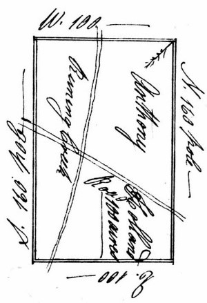 The Holland Family. Issued in 1787, Anthony Holland’s 200-acre Montgomery County grant should be easy to locate as, at the time, it encompassed both sides of Running Creek (branch of Bear Creek) and the Cross Creek Road (see right). However, roads have changed, and I have yet to resolve the exact location of this intersection per the 1787 land grant document. Furthermore, the written order was for 100 acres “on both sides of the Cross Creek Road” while the survey referenced “the Salisbury Road.” I believe this land may be located at the point where present-day Mission Church Road crosses Big Running Creek. If so, present-day Mission Church Road and the ancient Cross Creek Road may have merged with Barrier Store Road before heading west towards Mt. Pleasant. Chain carriers for this grant were Anthony’s believed son Sion Holland and previously mentioned Thomas Rigsby. As for Sion Holland, he acquired numerous tracts abutting the Mecklenburg/Cabarrus County line on Running Creek and Pole Bridge Branch. Sion Holland also received a small grant in now Cabarrus, along the east side of Meadow Creek. In December 1811 Anthony Holland and wife Gracey were received into Meadow Creek Baptist Church by letter, possibly transferring from Bear Creek Baptist which church was closer to where they lived.
From the petition, a signature for Richard Holland appears beside that of Anthony Holland, indicating he may be a son. Believing Anthony to be the brother of James, who died in Wake, their father would then be Richard Holland, who died in the 1760s Edgecombe County. If true, the given name of Anthony’s son Richard makes sense.
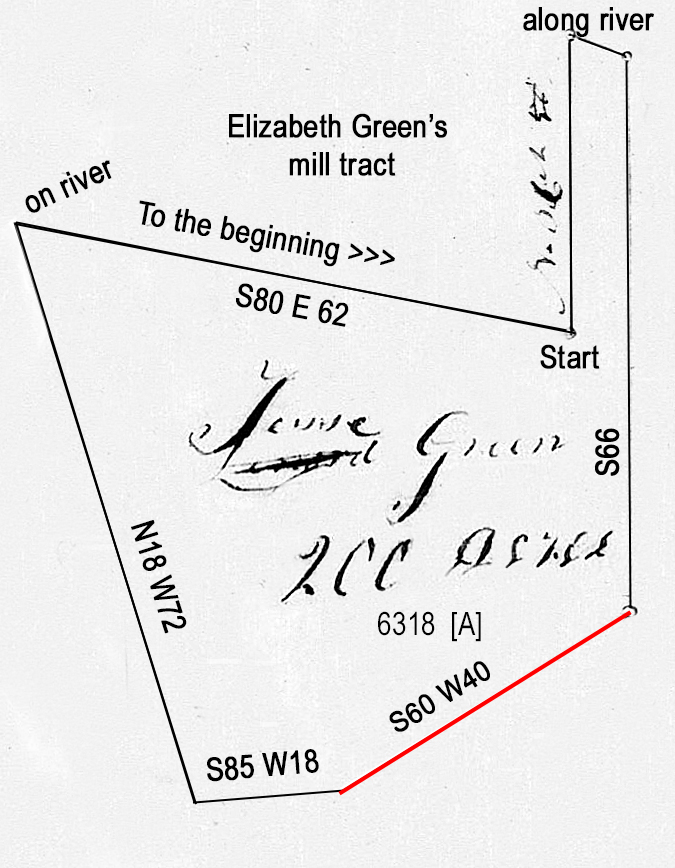
The Green Family. Leonard and Richard Green, and James and Anthony Holland served the newly formed Wake County per a court road work order in 1772. Likely named for Leonard’s father, I believe Richard is Leonard Green’s oldest son …or was Richard his baby brother? Leonard Green never received a grant for land in Wake County though mentions in grant documentation for others provide valuable insight. For instance, a grant issued to Daniel Oaks (244-Wake) in 1780 calls out acreage as “joining the lower side of the land whereon Leonard Green Sen’r lately lived.” Daniel Oaks’ daughter Mary married John Thomas, son of my DNA cousin Joseph Thomas. From the wording alone, one may suppose Leonard either died or moved. Also occurring in 1780, Andrew Peddy received a nearby land grant (288, Wake) that was “purchased by the said Peddy of Leonard Green, including the plantation where Leonard Green Junr now lives.” This means that as of 1780, two people named Leonard Green were living in Wake County.
In 1779 Leonard Green purchased land in Mecklenburg, now Cabarrus, where Hwy 24-27 crosses Rocky River (deed 10-475, Mecklenburg). William Barker, also from earlier in Wake County, witnessed the transaction. Leonard didn’t hold on to the property for long because he and wife Ann sold the land a year later. That transaction was witnessed by William Haynes and Jacob Self who purchased land nearby. Then, in 1783, Jacob’s brother Phillip received a grant (115, Montgomery) on the forks of Island Creek in Montgomery County “including Job Self’s upper improvement.” The chain carrier was none other than Leonard Green. In the same year “Lennard” Green also served as chain carrier for a nearby grant issued to Job Self (134, Montgomery) legally described as “including Self’s improvement.”
In 1779, the same year Leonard Green purchased his land in now Cabarrus County, Henry Kent of earlier in Wake County bought nearby property upon which was built Haynes Baptist church. Was this the same Leonard Green Senior as he who, a year later, was identified back in Wake as no longer living near Daniel Oaks? I think so. Looking back in time, Henry Kent also received a land grant in 1763 Edgecombe County which land he later sold to Thomas Holland, who happened likely to be the brother of Anthony Holland.
Richard Green, likely the son of Leonard, received two land grants in Wake County, with Henry Kent serving as chain carrier. In 1786 Richard (R) Green “of the County of Montgomery” sold his two tracts of land in Wake County to John Norris, for which Joseph Thomas witnessed the transactions. As for Leonard’s probable son Richard, who sold land in Wake County, he began acquiring land grants along Bear Creek beginning in 1783 Montgomery County. From this point, the Green family began moving westward, as did others. And, not to confuse the details, I believe another person named Richard Green settled in the eastern half of Montgomery County, the lands east of the Yadkin.
I must stop for now though many others should be mentioned in connection to beginnings in Wake County’s surrounding area. I’ll save that for a later day and hope to hear from you concerning thoughts as this piece should be long and detailed, weaving the fabric clothing an important migration of people from the north.

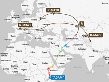 I grew up a happy towheaded young’un with hair indicative of some Northern European descent. My view concerning ethnicity began to change as my hair browned with age. Being a THOMAS with believed heritage originating in Wales, the advent of yDNA research through FamilytreeDNA.com led to beginnings much deeper in time (see Adam, right). Note that yDNA research traces son to father ancestry ever-so-deep into time without the dilemma of genetic halving encountered when using autosomal testing products such as can be purchased through Ancestry.com.
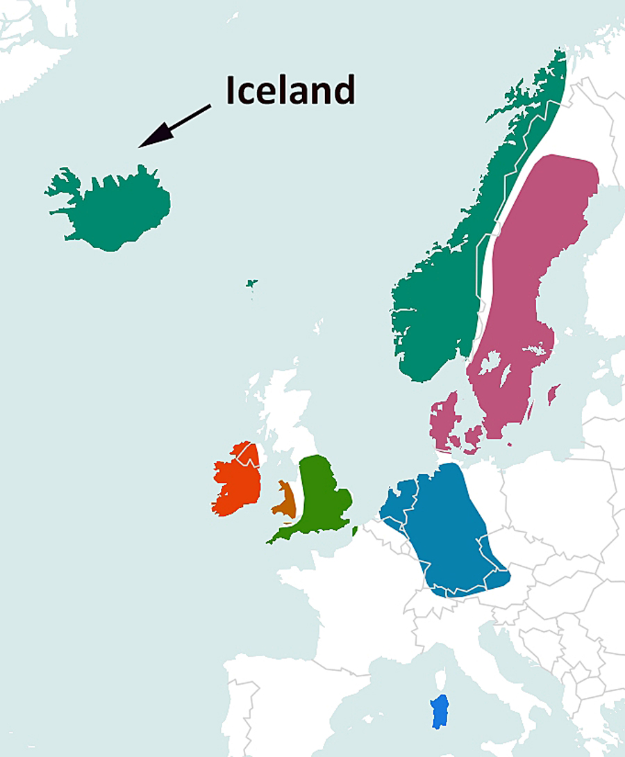 Testing with Ancestry provided the following map indicating the regions of the world where autosomal DNA looks most like mine. Of peculiarity, atDNA like mine is found in Iceland, Ireland, England, Norway and Sweden, but oddly not in Scotland ….drats! Note that the image (right) is a composite, combining results from both my father and mother. But which is which? Also included in the report is a breakdown of the places most matching my two parents, but again, which place matches which parent? To answer that question all I needed to do was to look separately at reports for known cousins on both my mother and father’s side of the family. Doing so allowed me to assign places representing atDNA reports most-closely matching each parent. Ancestry.com provided the following with the assignment of parentage determined by me.
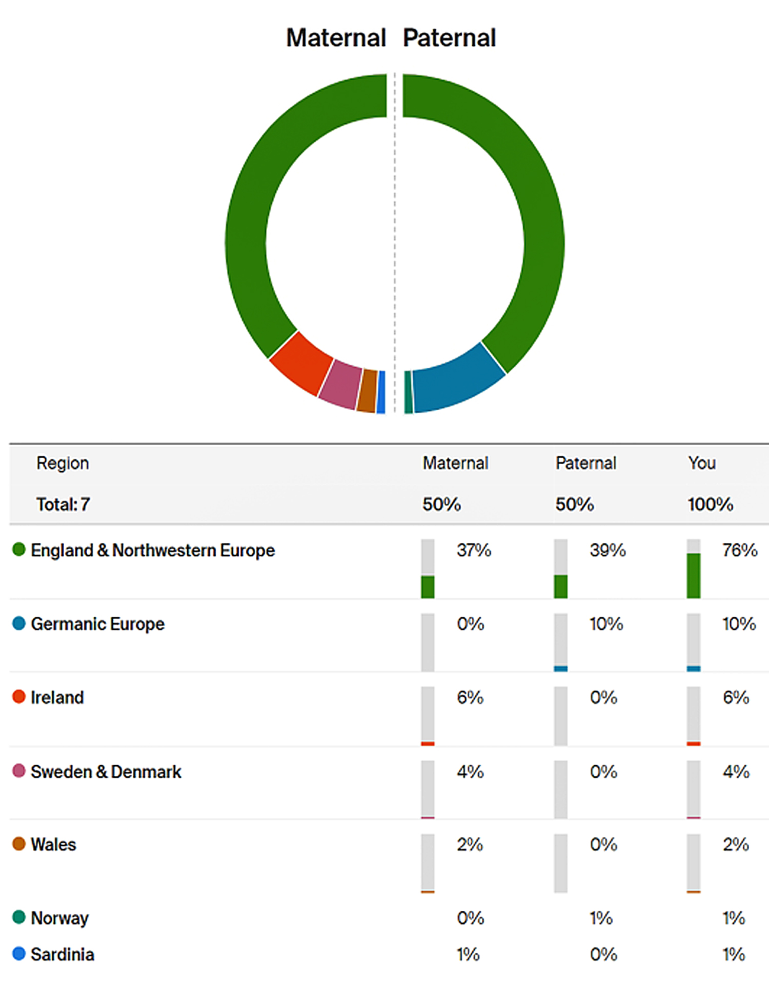
 Accordingly,
 The village was made entirely of sod, much like was constructed by Norwegians and others who settled the American West. And in front of the little church stood a small monument of a mother and child entitled the first mother in America.