This last weekend I learned that my namesake great grandfather once worked for John Coffee Brooks who was known in southwest Stanly County as “Coffee John.” And then, while browsing through online deed books in hopes of understanding my ancestor’s relation with the said Brooks, I discovered an unrelated conveyance which caught my attention. Having spent a great deal of time exploring the Barker family of Wake County, curiosity drew me to a deed naming “Amy Barker.” Who was she?
Thomas Barker of early Wake County was said in 1804 Tennessee that he once lived along the Yadkin River which bounds Stanly County. And now, in the annals of Stanly County, I happened upon this person named Amy Barker. What is her story, and does she somehow connect to the Barker family of Wake County? Amy does indeed represent a line of the family from Wake County and in telling her story I believe it best to begin at the beginning, with life in Wake County.
In 1815 Edmond Barker’s last will and testament was penned in Wake County, naming firstly his son Laban Barker (see below). Researchers claim Edmond to be the son of an earlier Joel Barker but concerning that thinking, I am not so certain. However, some of Edmond’s children end up in Middle Tennessee where a legal suit concerning rightful ownership of a slave connects their westward migration …keep Laban in mind.
Before moving on, Edmond Barker’s last will and testament as shared on Wikitree makes the following bequeaths:
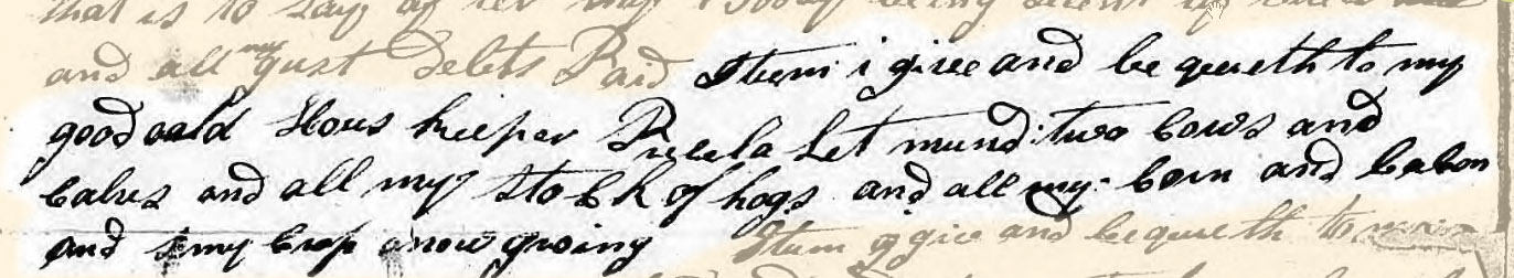
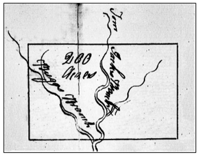
“…son Laban Barker one negro man named Gillis…unto son Hosea Barker one Negroe known by the name Mark…unto daughter Lydia Shaw four shillings…unto daughter Prisciller Barker one negro girl named Rachel during her natural life and the said negro and her increase be equally divided between her three children, Briggs, Sterling and Hosea Barker…unto son Edmund Barker the land I now live on containing 200 acres and one bed and furniture…unto son Asa Barker five shillings…unto daughter Prenesse Barker one Negro girl named Gelly and the land which I bought of Aaron Read containing 75 acres one bed and furniture…residue of my estate, be sold, and the balance divided between children of my decd son Abner Barker to wit John Barker, Willis Barker, Sally Barker, Allen Barker and Polly Barker…ordain son Edmund Barker Executor.
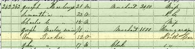
Now, found in Stanly County deed book 2, page 337, and dated 11 Jun 1850, the following conveyance calls out “William B. Hines and others to Ruben Kendall.” Within the description,
“Amy Barker of the county of Holmes in the state of Mississippi, William B. Hines and Jane F., his wife, of Carroll County in said state, Joseph Marlow and Samantha A his wife of the county of Yazoo of state aforesaid, which said Jane F., Sarah, and Samantha are daughters of the said Amy, do nominate, constitute and appoint Ruben Kendall of Stanly County, State of North Carolina, our true and lawful agent and attorney for us in our names to receive from John H. Treadwell, clerk and master in equity of said county of Stanly , our shares of the proceeds of the lands of Charles C. [Carter] Coppege, des’d sold by a decree of the court of equity in and for the said county.”
From the 1850 census, being the same year as the above appointment, Amy Barker is found living in the home of her daughter Samantha in Holmes County, Mississippi. Note also living in the household is Samantha’s husband and father-in-law who was born in Hungary.
Numerous entries on Ancestry pick up the family history at this point, telling of Amy Barker’s family and their life though I believe important information from Stanly County has been overlooked. The aforementioned attorney appointment is informative; however, Amy’s “Barker family” ancestry would likely avoid detection unless one looked a bit deeper, into related Stanly County loose estate papers. It is there, in the estate papers of the said Charles C. Coppedge, where mention of Amy’s marriage to Laban Barker is found:
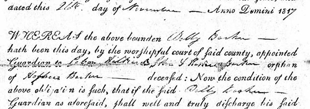
“The petition of ——-Hines and wife Jane F. Hines, Joseph Marlow and wife Samantha A Marlow, & Sarah C. Coppege, the last named an infant under the age of twenty-one years who petitions by her next friend Reuben Kendall and of Mrs. Amy Coppedge widow of the late Barker humbly compliancy show to your Honor that Charles C. Coppedge late of Stanly County died seized & possessed of about two hundred and fifty acres of land situated on said County adjoining the lands of James Allen Esq, Robert Lanier, & others and that the said Charley C. left your petitioners, Janes A. intermarried with Joseph Marlow, and Sarah C Coppedge his children, and Amy since intermarried with Laban Barker has departed this life. Your petitioners shew therefore that they are tenants in common of said tract or parcel of land. The said Amy Barker having a right of dower in the land which has never been assigned to her …”
From the above we learn that Amy (last name not yet known) married first Charles C. Coppedge and apparently shortly after his death she married Laban Barker. From the 1850 Mississippi census Amy appears to be the mother of John Barker who at that time was 17 years old. Therefore, it appears that Amy may have been married to Laban Barker as early as 1833, well before Stanly County was cut from Montgomery in 1842. Out of curiosity and needing an answer, when did Charles C. Coppedge die and for some reason, does the above documentation arise from a much earlier passing of said Coppedge?
Looking one last time toward Wake County, on 18 Sep 1805, Hosea Barker as mentioned later in his father’s last will and testament, married Polly Hays. Hosea’s brother Laban Barker who was still residing in Wake County served as bondsman. On 8 Jul 1814, being roughly a year prior to the writing of Hosea’s father’s last will and testament, Hosea Barker penned his own last will and testament in Mecklenburg County, North Carolina. Mentioned is wife Polly and their children to whom the said Hosea appoints Thomas Grier Junr, and Joseph McRum, guardians. Witnessed by John Bigham and Thomas [P] Swann, Hosea appointed trusty friends James Hartt Esq, and Samuel Neel to execute the will. The will was probated Feb 1815. From related land and estate records it appears Hosea Barker lived south of present-day Charlotte around the Steel Creek community.
Two years following the death of Hosea Barker, Polly, his widow, petitioned the court for guardianship of her minor children. As seen below, Polly names children “Laban, Hilliard, John & Hosea? Barker.”
At this point I could go further. For instance, a person named Hilliard Barker, born 1811 North Carolina, lived in 1880 Texas. Also, as will be discussed in a later post, the mystery person Thomas Barker will make another appearance along the waters of Rocky River. I’ve learned more about this person though I still have no clue as to his extended family.
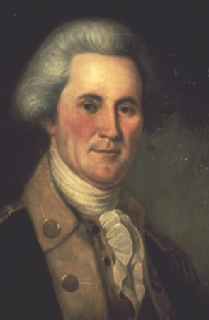
Seated in his Logan County, Kentucky home, John Powers penned a passionate plea addressing the Governor and the People of Tennessee. Governor John Sevier is no ordinary man as he was a famed Indian fighter, a leader of Over Mountain men serving in the Battle of Kings Mountain, and a statesman important to the founding of Tennessee. John Powers levied his concerns against the said John Sevier:
“As no doubt, from the exalted station you occupy; from the distinguished confidence your fellow citizens have reposed in you, you must be a just man, and a true republican; I take the liberty of offering to you, through the medium of the public papers evidence sufficient, in my opinion, to convince you, or at least the public, that you do unjustly, and contrary to right, hold in your possession, and detain in slavery, a certain woman of color, by the name of POLL LUCOST [Lucas], with her three children.”
An amazing letter, this is unlike any I have ever read as John Powers seemingly risked all on behalf of an apparently beloved family of color he referred to as being friendless. Assuming John Powers to be racially white and as expressed in his own gentle word, it seems much was at stake as he and Poll Lucost were raised in the same household. Concerning Poll’s mother and the rest of her family:
“…they are friendless; the voice of humanity and justice is too feeble to call forth the energies that are necessary to contest in a tedious lawsuit with a man possessed of the great personal influence of the governor of Tennessee ….having been raised in the same family with Poll Lucust, from infancy to manhood, and well knowing her justly entitled to her freedom, when I found you determined to keep her as a slave – I caused a suit to be instituted against you, at Jonesborough, about three hundred and sixty miles from my house.”
Seeking to sway public sentiment in a suit he apparently raised 360 miles to the east in Jonesborough, Washington County, Tennessee, John Powers addressed the public and Governor through a lengthy letter he published August 22, 1804.
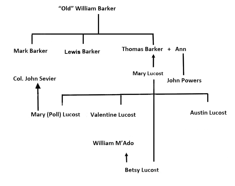
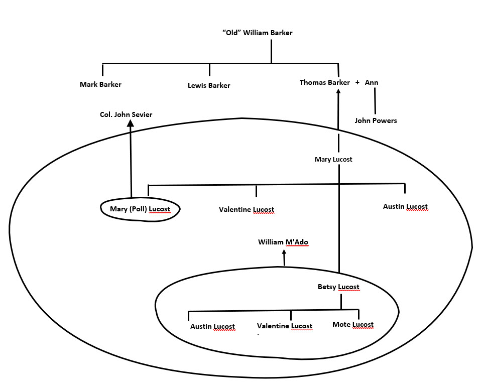
Who is Poll and who is the said John Powers? Firstly, Mary Lucost is the mother of the above-mentioned Poll Lucost, and Mary’s other children are Val and Austin Lucost. Mary was always considered a free woman and remained legally free though out of necessity she bound herself by indenture to Thomas Barker for a term of seven years which court document John Powers stated he had in his possession. Mary died before her seven-year indenture matured and little of her, her children, and others is known prior to her death.
From the letter we learn of Thomas Barker’s brothers and of their father William. Some say Thomas is the son of Joel Barker but that cannot be true. Thomas Barker may have been a contemporary to Poll Lucost as the two appeared to grow up from infancy alongside each other in the same household. Since from deposition Thomas Barker is said to be the son of William Barker, then Poll, surely lived in the same home alongside her mother Mary Lucost and the rest of her immediate family. Mary Lucost and her family moved somewhere west, beyond the Yadkin River, with the family of Thomas Barker where I believe she likely died ca. 1770 -1790. Thomas Barker’s wife, Ann, stated she knew Mary Lucost, the mother, for a term of eight to ten years prior to the death of the said Mary Lucost. Ann’s first knowledge of Mary Locust may go back to Wake County during childhood or possibly later, during a time they lived somewhat together beyond the Yadkin …being a time Ann was married to Thomas Barker.
Thomas Barker, who married Ann, cannot be the person of same name who died ca. 1763 and whose children Ephraim and William sold their rights to neighbor Christopher Osborne. I tried in earlier posts to make that connection though timing simply does not work. Realizing Thomas Barker, as mentioned in the letter, is contemporary to Mary Locust’s daughter Poll, how do we connect him to his father, William Barker, as was also declared? Let’s dig a bit deeper.
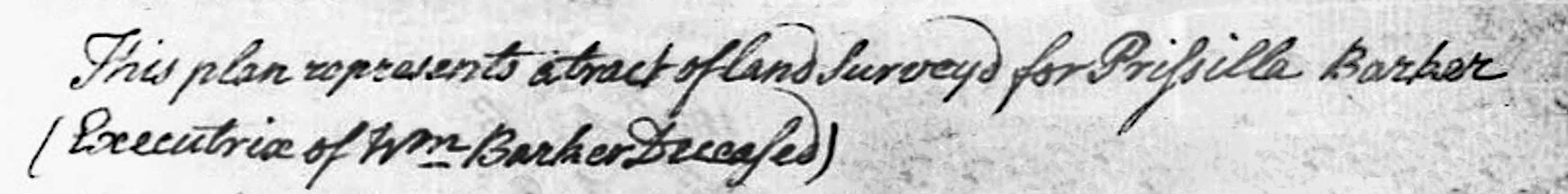
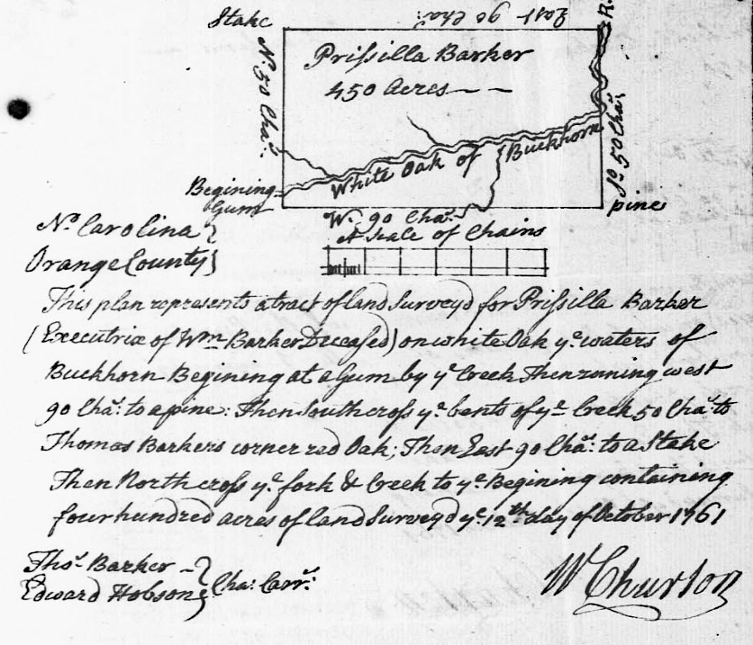
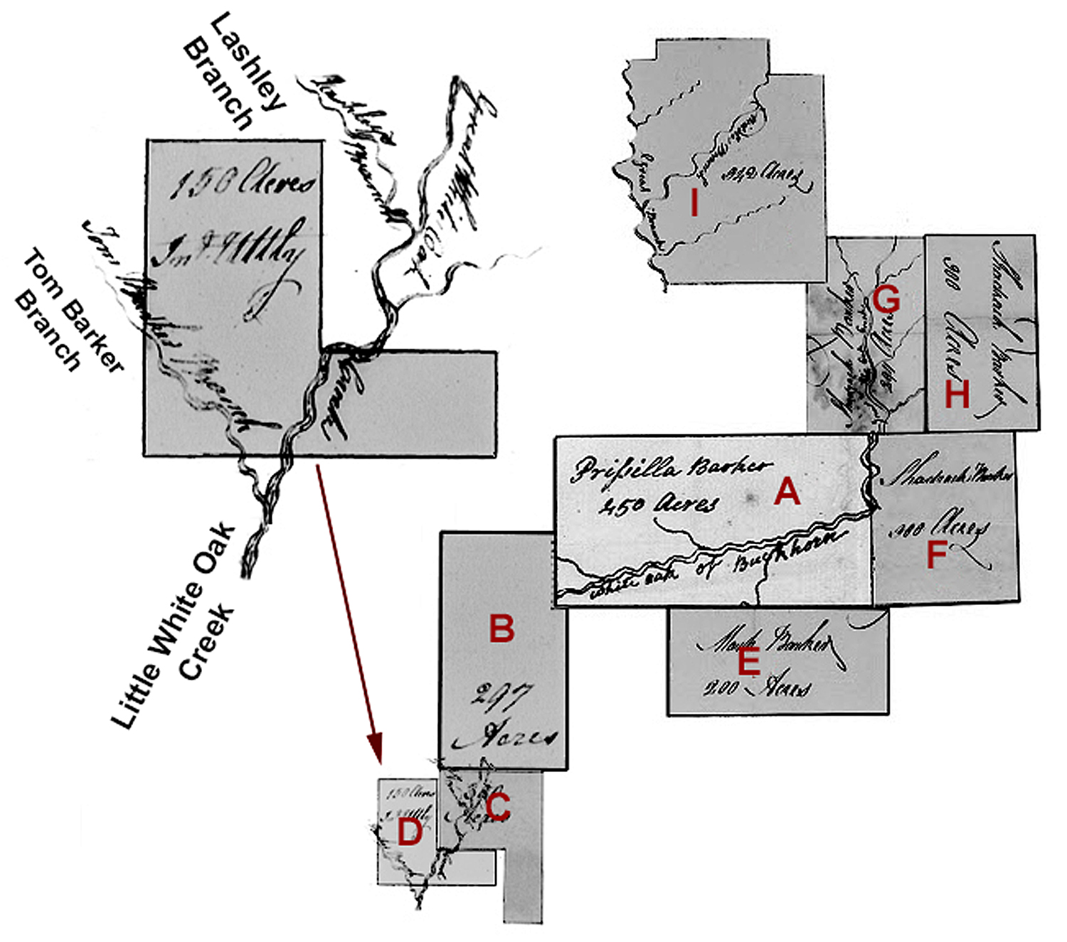
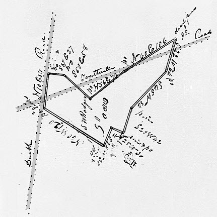
Issued in 1761 Orange County, North Carolina, the above appears in the survey for “Prissilla” Barker’s 450-acre grant. Some say Priscilla is the wife of Thomas Barker who died a year or so later though customarily she would not be the executrix for another man, William Barker, if that were the case. Priscilla is indeed the wife and widow of William Barker, deceased. And following her husband’s death, the widow Barker married Samuel Letman and in 17?? and registered in 1787, the said Priscilla Letman deeded “to my loving son Mark Barker, being my lands and plantation whereon said Mark Barker now dwells,” 125 acres bounded by a line of agreement made between myself and my son William Barker crossing White Oak Creek and Rocky Ford (deed H-65, Wake). The tract is “the upper part of [Priscilla’s] certain survey of 450 acres.” Witnesses to the deed were Brittain Utley and Lewis (X) Barker. Such documentation is important and should not be overlooked.
Overwhelmingly stated in depositions revealed in John Powers’ 1802 letter, and supported through documentation, it is clear beyond discussion that Priscilla is the wife and widow of William Barker who died prior to 1761. And from the deed description above, we now know that the deceased William Barker is the father of both Mark Barker and William Barker. Furthermore, one must question Lewis Barker who witnessed the aforementioned deed. This is especially true as depositions from John Powers’ letter verifies that William and Priscilla’s sons Mark and William Barker have a brother named Lewis Barker. Surely Lewis Barker who witnessed a transaction by his mother is the same Lewis Barker who was deposed and gave statement per John Powers’ letter. Finally, serving as witness in the above-mentioned deed is Brittain Utley, the son of John Utley who also testified per the letter. All the players are in place though one question remains, …who is Thomas Barker?
From the survey for Priscilla’s 450-acre grant which was likely entered by her deceased husband William Barker, not only did a person named Thomas Barker serve as chain bearer, but the land itself is described as joining the lands owned by “Thomas Barker.” That fact is magically given genealogical meaning by family historians as in a 1778 caveat, being a mechanism for resolving a legal land conflict, we learn that a person named Thomas Barker died ca. 1763. And as already stated, this deceased Thomas Barker once owned land adjoining that of Priscilla Barker’s 450 acres. Who is Thomas Barker?
Firstly, Thomas Barker who died ca. 1763 cannot be the son of William and Priscilla Barker as their son of that name appears prominently as a deponent per the letter written by John Powers in 1802 Kentucky. That Thomas Barker, alive and well in 1802, is legally identified through depositions by his brothers Mark and Lewis. It is possible the same Thomas Barker who moved to Kentucky could be the one who served as survey chain carrier and whose land in 1761 adjoined that of the widow Barker’s 450 acres. If so, he would have likely been one of the older children in William and Priscilla’s family if not the oldest. Even so, I struggle with the idea that such a person born ca. 1740 would have been gallivanting around Middle Tennessee and Logan Kentucky during the early 1800’s though records undeniably point in that direction.
On the other hand, I think it is equally plausible that Thomas Barker whose land adjoined that of Priscilla in 1761 is the same as he who died ca. 1763. That person cannot be successfully linked to the tree (see green lineage in familytree near bottom of page). As for William and Priscilla Barker’s son Thomas, maybe born a bit later, he avoids record before leaving Wake County with the indentured Mary Locust and family.
There is one last possibility worth considering as it is known that Thomas Barker who died ca. 1763 left a wife and sons William and Ephraim, who I’ve found later in now Cabarrus County, North Carolina. What if Thomas Barker’s wife, name unknown, gave birth to the two sons and yet had a younger child named Thomas for their father? Such a child could have been raised by an uncle or maybe his grandmother and therefore being given a family heritage based on love and not blood. Maybe this child was not truly the son of William though for the most part he could have been raised by his Uncle William Barker. Such thinking is a stretch though the suggested possibility does exist. For now, I’ll move on as I do not want to get bogged down in piecing together a troubled genealogy that may be conflated in the very real possibility that early ancestors lived in hard times only to be made whole through undocumented love and the care of neighbors and family.
Getting back to Mary Lucost and her son Austin Lucost, from the letter, “he [Austin] lived on the waters of Holton [Holston River] as a free man.” Austin Locust purchased his wife, (name not given in the letter) from Governor John Sevier. From a lone deed in Jefferson County, Tennessee, Austin conveyed “seventy-five acres [on the north side of Mays Mountain] on which I now live, in consideration of the love and good-will I have and bear toward the said Hodge and Vance.” Austin deeded his rights back to the two men who originally, and possibly graciously, “secured the said land to me [Austin] during my life-time and during the life of my wife Rachael.”
It is apparent that Governor John Sevier somehow encountered the Lucost family in such a way leading to the enslavement of the formerly free Poll Lucas while also selling to her brother [the free Austin Locust], a slave named Rachael who became the said Austin’s wife. Complicated. And as for their brother Val Lucost, John Powers further stated that Mary Locust’s son “Val Lucust lives in North Carolina, as a free man,no body pretending to set up any claim to him.” That statement is not wholly true as three years prior to publishing the letter, in 1801, the following was published in Raleigh, North Carolina.
[Raleigh Register, 6 October 1801]
FREE NEGRO STEALERS.
On the 29th Instant, about Mid’ Night, four Men came to the House of VALENTINE LOCUST, an aged Free Negro, who resides on Leek Creek, in Wake County, and calling at the Door to gain Admittance, as soon as the Door was opened, Two of them entered with Clubs, and instantaneously knocked down the old Man and his Wife, and beat them to such a Degree as scarcely to leave Life; and whilst they were in that Situation, the Robbers carried off two of their Children, a Boy named Absalom, aged about twelve Years, of a yellowish Complexion, who is just able to read and write; a Girl, named Polly, aged about five Years, of a Complexion more yellow than her Brother.
The Father of the Children is a respectable and industrious old Man, who has hitherto made ample Provisions for himself and Family; and it is hoped, from the peculiar Circumstances of his Case, arising from his Incapacity to bear Witness, except against his own Colour, added to the distressed situation he must be place in after the Loss of his two Children, will awaken the Feelings of the Humane, and that they will contribute every Thing in their Power that may tend to the detecting and punishing of such vile Offenders.
It is supposed the Perpetrators of this Offence, will endeavor to convey their Prey to the State of Georgia, in the Character of Slaves, for the Purpose of Traffic. Wake County, N. Carolina. Sep. 30, 1801
[The Printers in the U. States who are desirous of detecting the Offenders, will give this a Place in their Papers.]
In 1801 Valentine Locust was considered to be “an old man” and a free person of color living somewhat normally in Wake County. He was not alone as numerous free families of color in our county ca. 1800 were impacted by the worsening black codes. This is an interesting population, one seldom written about.
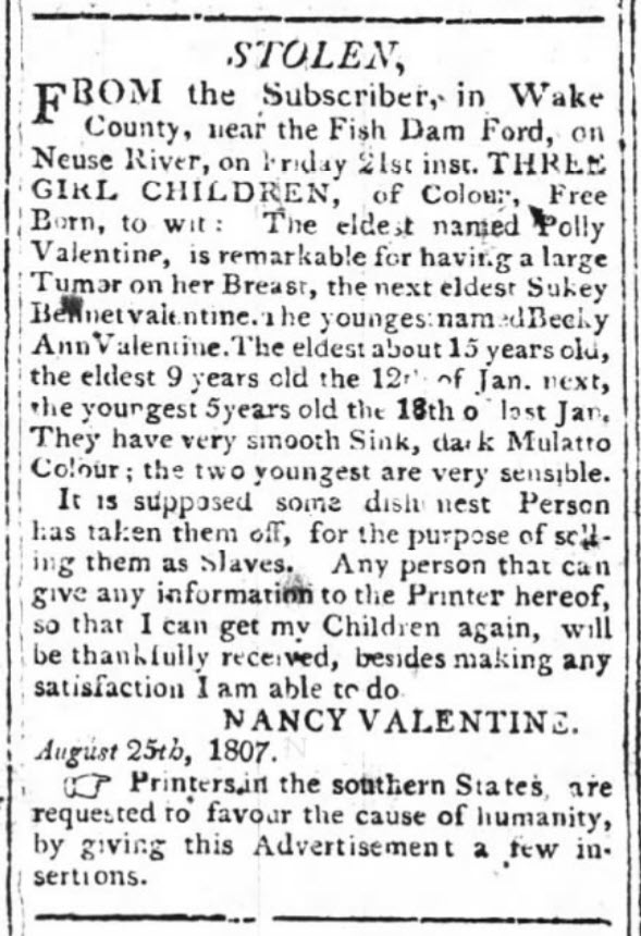
Among the mixed-race citizens were several named Valentine, whether used as a given or surname. Additionally, in 1807, a person named Nancy Valentine posted a newspaper (right) notice concerning three of her children who had been taken near Fish Dam Ford on the Neuse River (present-day area of Falls Lake).
Nearby, in 1784, another person of color identified as Valentine Austin of Franklin County, first appears in Wake County when he purchased 100 acres on a branch of Fall Creek from Nathaniel Bridges. It appears the area surrounding Fish Dam Ford in northern Wake was particularly brutal as period newspaper notices account for numerous horse thefts and missing wallets as well as people of color who were believed to have been taken. It seems most of the people of color passing through northern Wake County had ties back to Franklin and other counties to the east.
Later, in 1798, the same Valentine Austin mentioned above purchased 100 acres in southwest Wake County from William Love to whom the land had been originally issued as a grant during the same year. “Leek Creek” as identified in the notice may have been Lick Creek or Branch, of which there are many such ephemeral streams in Wake County. However, I believe odds are good that the stream where Austin Locust lived in Wake County forked off Cary’s Branch near the lands of Peddy and Utley in southwest Wake. Many, both Black and White, who first lived in the northeast of Wake County, eventually moved or bought additional lands in the south.
Valentine Locust, son of Mary as written in John Powers’ letter, served in the Revolutionary War. Rachael, his wife and widow, filed for a pension in the 1830’s. We know that Valentine enlisted 26 Apr 1776 for 2 ½ years in 2nd Company, North Carolina Battalion. Soldiers were paid in land since North Carolina was land rich though money poor. For his service, Valentine Locust received warrant No. 782 in 1784, for 228 acres of land situated on Spring Creek of Red River in Robertson County, then Davidson County, Tennessee. Spring Creek rises in an area geographically known as “the Barrens” or Barren Plains before emptying in the Red River near the Logan County, Kentucky line. Of all people and of all the places, Valentine’s acquisition of land in 1784 connects to people who are later mentioned in John Powers’ public plea.
Looking deeper into the letter published by John Powers, all remembered Mary Locust as being an old lady of color who passed as free. Witnesses confirmed her children were as she had stated, and she was neither Black nor White as they had always heard her mother was “Indian.” Lewis Barker stated that Mary Locust went from Wake County with his brother Thomas Barker to the Yadkin River, where he, Lewis Barker, saw her some other time.” People were clearly in motion.
Mark Barker stated that Mary Locust formerly lived with his mother and that he had also seen Mary’s two daughters on the Yadkin with his brother Thomas Barker. Note that the Yadkin River is long, rising near Blowing Rock in North Carolina, flowing southeast to join the Great Pee Dee in southern Stanly County. The families could have set up a home anywhere along the river’s path. But also, during this time was the Revolutionary war and what impact did that have on those who had only recently moved and settled? Reviewing grants and deeds in the numerous counties along the river’s path, I have not found any documentation clearly identifying where Thomas Barker settled before coming to Tennessee. Furthermore, John Utley stated that he was acquainted with Mary Lucost some forty or fifty years back (ca. 1752-1762) while she lived with “old Mr. William Barker,” father of Thomas Barker, with whom she removed from the county of Wake to the Yadkin River.
Appearing before justices West Maulding and Richard Boyce at the home of Clayton Talbot in the town of Russellville, Logan County, Kentucky, John Powers, Celia Maulding, Thomas Barker and Anne Barker his wife also provided statements. As for John Powers, we learned he “is the son of Mrs. Thomas Barker,” indicating that the said Thomas’ wife Ann had likely been previously married. Ann Barker knew of Mary Lucost for 8-10 years prior to the death of said Mary. As earlier discussed, was Ann married to Thomas Barker when she met the said Mary, or did she know of Mary beforehand, maybe in childhood?
Illustrating the impact of the governor’s actions, John Powers stated in his letter that the children of Mary Locus’ daughter Betsy “were held as slaves by Wm M’Ado, who publicly, in Robertson County court, at two different times, acknowledged their freedom and had them bound to him as poor orphans.” Thomas Barker further stated that “the said Mary [Locust] voluntarily indentured herself to him, for the space of seven years, in consideration of the payment of twenty-one pounds, by, this deponent, to the use of the said Mary; and the said Mary died before the expiration of the said term of seven years.” That he, Thomas Barker, never held said Mary as a slave. And finally, from depositions revealed in the letter, Thomas Barker’s wife Ann and their daughter Celia Mauldin spoke to birth and the legitimacy of Mary’s grandchildren.
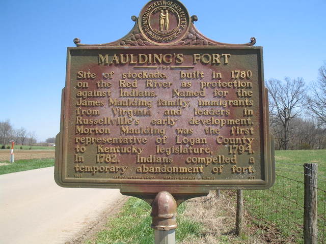
Turning the page and moving west, Thomas Barker, named in John Power’s letter, can clearly be found in Logan County Kentucky as well as Robertson County, Tennessee. Not only there, but a person of that name seems to appear a bit to the south in Dickson and later Hickman County. In fact, what I see in land documentation may represent two or more branches of the extended Wake County, North Carolina Barker family who settled in Tennessee over a period of time (more later). However, and back to Thomas Barker who appeared in John Power’s letter, the area where he first settled in Tennessee was situated along the western extent of the Tennessee/Kentucky State line on the south fork of the Red River in a geographical region called the Barrens. The Barker family married into the Maulding family who, in 1780, built a stockade along the Red River called “Mauldings Fort” in fear of attack by the Indigenous people. Nearby is also the site of Red River Meeting House, where the first-ever religious camp meeting was held in America in June 1800. Organized by Presbyterian Minister James McGready, thousands of hungry souls gathered at the 1800 Meeting which marks the important start of the Second Great Awakening.
In an earlier post I commented on the merciful tone of John Powers’ letter. It turns out the observation is spot-on as John Powers was a Methodist preacher. As will be shown in a little more detail, John Powers eventually moved to Bond County Illinois, where in February 1816, he preached a sermon at Fort Jones. Powers was also one of the first judges in Bond County, Illinois.
Back to Thomas Barker, did he settle only on the Red River, or was his movement west punctuated by earlier stops along the way? Did he make other land purchases in Tennessee? Did Thomas Barker move to Tennessee near the turn of the 19th century or was he there earlier, possibly during or shortly after the Revolution? What do we know of him prior to Logan County Kentucky and of all people, how did Poll’s children end up in the hands of powerful John Sevier, who lived 360 miles to the east in Washington County, Tennessee? Since this Kentucky fellow is not Thomas Barker who died ca. 1763, then what is his story from the time he left Wake with Mary Lucost, the person of color who he indentured?
As a starting point, it is known that John Powers, Thomas Barker, and Thomas’ wife Ann provided statements at the same time at the residence of Clayton Talbot in Russellville, Kentucky. But earlier, in then Tennessee County, near the “western boundary of Sumner County and the Virginia line”, being in May 1789, a person named Thomas Clark received a military warrant (Deed A-92, Montgomery County TN) for 128 acres on north side of the Red River and on the east side of “Thomas Barker’s plantation” on the “Barren.” So, it appears Thomas Barker had a plantation in Tennessee, early on, prior to 1789. Note that Middle Tennessee rapidly divided following the end of the Revolution with Tennessee County forming from Davidson followed by Robertson from Tennessee. Then was Montgomery, Stewart, Hickman, and Dickson to the west.
In Oct 1799, Thomas Barker of Robertson County Tennessee purchased 100 acres situated on the state line on the forks of Red River in Logan County, Kentucky. This land was initially granted to Solomon Perkins in 1796. And then in Oct 1801, John Powers of Robertson County TN sold to Lewis Barker “of same,” 200 acres on the fork of the Red River (Deed A1-568, Logan KY) joining Thomas Barker and Lewis Barker. I guess it is possible two unrelated families of Thomas and Lewis Barker could have acquired adjoining lands without sharing kindred relations though such coincidence is highly unlikely. This deed from John Powers is used to declare Thomas Barker the father of said Lewis Barker per an article in the August 1932 issue of the N. C. Historical and Genealogical Record. So, at the very least we know from the deed that Thomas Barker and Lewis must somehow be related. Furthermore, we know John Powers and Thomas Barker owned adjoining lands and signing in witness was none other than William Mc’Ado, the fellow to whom John Powers expressed disdain in his letter directed at Gov. John Sevier:
“Your example in detaining Poll and her children, has had a very fatal effect in Logan County Kentucky, where three of Betsey’s children are held as slaves, under Wm M’Ado, who publicly, in Robertson county court, at two different times, acknowledged their freedom and had them bound to him as poor orphans.”
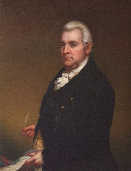
Ninian Edwards
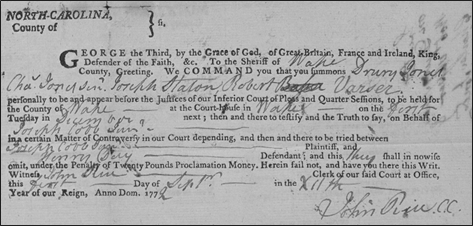
In Jun 1802, Thomas Barker, Anne Barker his wife, Celia Maulding, and John Powers, were called to the home of Clayton Talbot by justices West Maulding and Richard Boyce to testify “in a certain matter of controversy” where Ninian Edwards was plaintiff and Morton Maulding defendant. Justice West Maulding was Thomas and Anne Barker’s son-in-law as he married the above-named Celia Barker in 1793. Furthermore, Ninian Edwards happens not to be your ordinary run-of-the mill plaintiff. Settling in Logan County about the time of this court action, Ninian held the rank of major in the Kentucky militia. He was a circuit judge and by 1806 became chief justice of Kentucky’s Court of Appeals. Ninian Edwards became governor of the new state of Illinois in 1809 where he later served as senator from 1818-1824.
Curious concerning the above court actions, the year following Lewis Barker’s purchase of land from John Powers, I learned that Logan County deeds record the March 1802 indenture of Betsy Lucas and her four children to none other than Ninian Edwards. Central to John Powers’ letter and occurring only three months prior to Ninian’s “certain matter of concern,” Betsy’s named children in the deed are the same as those appearing in John Powers’ letter:
James Lucas – aged about sixteen years
Austin Lucas – aged about thirteen years
Moses [Mote] Lucas – aged about ten years
Hannah Lucas – aged about fourteen years
I have pondered much about Betsy and her children, of how they fell into the hands of Gov. John Sevier. From the hands of common citizenry living hundreds of miles away, finding a plausible social mechanism leading to the forbidden acquisition has been quite vexing. And now, here we see the family of color indentured into the hands of Ninian Edwards who certainly moved within the same circles as Governor John Sevier. Maybe the indentured family moved from Lewis Barker to the powerful Ninian Edwards before becoming the tainted property of the Governor of Tennessee? The timeline of events from the Lucas family indenture to appearing in John Powers’ letter certainly supports such a scenario.
Often family history is less to do about a particular place or county and more about a region, maybe defined by a river running through it. And as was the case earlier in North Carolina, there came a time when members of the family divided and moved on as dictated by the personal desires of each. As for Thomas Barker, he can be found along the state line in both Kentucky and Tennessee. Then, around 1810, records show the family spreading deeper into Kentucky and across the Ohio River to Illinois. Some remained in or possibly settled to the west, in Tennessee. The following offers an overview of related land records:
Jul 1785, William McAdow, assignee of Joshua Adcock, a private in the Continental line, 274 acres in Davidson County on the south side of Red River below the Rocky Spring and in the Barrens. Further assignment: Henry Bradford, Daniel Flannery, Thomas Barker.
May 1789, Tennessee County, Thomas Clark received a military warrant (Deed A-92, Montgomery County TN) for 128 acres on north side of the Red River, and on the east side of “Thomas Barker’s plantation” on the “Barren.”
Undated though a timeframe can be deduced from other entries. The following land grant entries likely occurred in the late 1790s:
Jno Hinton Heirs – No. 2929, being 640 acres on the Middle Fork of Big Barren River near an “Indian Camp on the south side of the fork where William Barker, William McAdow, & Lewis Barker were shooting at a tree and cut the bullets running so as to include the low grounds on the creek for compliment.” Was this John Hinton living earlier in Wake County?
George Trulock’s Heirs – No. 2974, being 640 acres “on the Middle Fork of the Big Barren River near the head of a branch where William Barker and Elijah Allen killed two Buffaloes in a beaver dam on the south side of the Middle Fork. William Barker”
William Gee – No. 40, being 228 acres on the Middle Fork of the Big Barren River on the south side beginning at the lower end of the low grounds opposite to a high bluff where William Barker & William —- crossed the river last fall when they were hunting to run up the river on the south side. B.”
In Oct 1799, Thomas Barker of Robertson County Tennessee purchased 100 acres from the estate of Timothy Chandler. The land was situated on the state line on the forks of Red River in Logan County, Kentucky, and was initially granted to Solomon Perkins in 1796.
October 1801, John Powers of Robertson County TNsold to Lewis Barker “of same,” 200 acres on the fork of the Red River (Deed A1-568, Logan KY) joining Thomas Barker and Solomon Perkins.
October 1802, Lewis Barker, entered 400 acres on the Red River lying in the county of Tennessee west of the Cumberland Mountains on the waters of Red River on the State line, joining Wm. McAdoo and Thomas Barker. Originated for the service of Samuel Griffis, assigned to Lewis Barker
February 1803 Thomas Barker of Robertson County TN sold 200 acres on the Red River in Logan County KY (Deed A1-578, Logan KY).
April 27 1804, Thomas Barker of Logan sold 228 acres on the south fork of Red River on the Barren (Deed A-190, Robertson) issued 15 Sep 1787
August 1804, Lewis Barker now of Livingston Kentucky to Alexander Gordon, being roughly the same 400 acres of land as issued to said Lewis Barker as appears in No. 2 above. As of 1804 one of the survey lines changed “as agreed” and no longer is Thomas Barker mentioned. Instead, this deed (Deed f-40 Robertson TN) refers to “said Barker’s old Plantation,” referring to Lewis Barker, not Thomas. Thomas Barker is declared the father of said Lewis Barker per an article in the August 1932 issue of the N. C. Historical and Genealogical Record.
December 1807 by his attorney West Maulding, Thomas Barker of then Dickson County TN sold 200 acres in Logan County situated on the State line and in the Barrens (Deed B-127, Logan KY).
May 1811, Thomas Barker now of the Illinois Territory sold four people he had enslaved (Deed C-235 Logan Ky) being Moses, Grace, Bob, and Lucy, which slaves were sold to Joseph Woolfolk.
The following year, in October 1812, Thomas Barker of place not mentioned, sold to Joseph Curd “one-half of a claim of land pending a suit to reclaim the land, it being sold to a certain John Copeland by West Maulding as attorney in fact said Barker never gave any such power.”
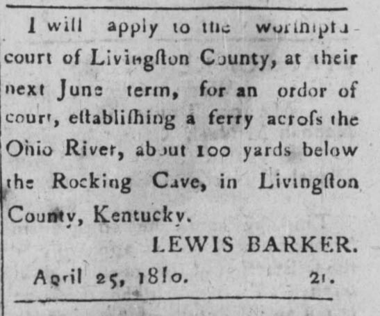
Published 25 May 1810 in The Farmer’s Friend (Russellville, Logan County Ky), Lewis Barker was living at that time in Livingston Kentucky where he labored to establish a ferry crossing the Ohio River below “Rocky Cave,” now known as Cave-In-Rock. Cave-in-Rock is located across the river in what would become the state of Illinois eight years later. “Beginning in the 1790s, Cave-in-Rock became a refuge stronghold for frontier outlaws, on the run from the law which included river pirates and highwaymen.” This was a rough place best suited for the toughest of men. I can imagine life for the Barker family during these early days.
Next, in 1811, Thomas Barker of Illinois Territory deeded in Logan County four people he had enslaved. Living in Illinois, Thomas Barkers’ likely son Lewis Barker served as captain in the Wabash Territory Militia. In 1818 Lewis became the first Illinois state senator elected for the county of Pope in Illinois. Records of a person named “Thomas Barker” in Illinois government appear well into the 1830’s, making me wonder if that person could be a son or even a grandson of this family? Note that I am merely stirring the pot in the hope others will taste and add to the proverbial stock.
Looking back to 1799 Robertson County, Tennessee, family significance can be found in Thomas Barker’s purchase of land once belonging to Solomon Perkins. The transaction represented more than land and a mere exchange of money. The land in question fell into the hands of Thomas Barker’s son Lewis Barker and then:
“…on Nov. 7, 1813, in Pope County, Ill., Isaac [Perkins], then 18 years old, married Jane Barker (1797-1862), daughter of Lewis Barker, a neighbor of Solomon Perkins who, like Solomon, had been born in North Carolina and settled in Livingston County, Kentucky, before coming to Cave-in-the-Rock.”
Jane Barkers’ husband, Isaac Perkins, served as a private under the command of Major Isaac Stillman in the Black Hawk War of 1832. Stillman and his men, including Perkins, engaged Black Hawk forces on 14 May 1832, in the first battle of the Black Hawk War, known as the Battle of Sycamore, or better remembered as Stillman’s Run. Not realizing they had made camp near the Black Hawk warriors, Stillman’s ill trained troops panicked upon encountering the Indians which led to a disastrous retreat, hence the name, “Stillman’s Run.” “Black Hawk warriors slaughtered, scalped, and beheaded the few soldiers who attempted to make a stand. Among those who lost their lives was Jane Barker’s husband, Private Isaac Perkins.” The following day a state militia led by a 23-year-old captain named Abraham Lincoln came upon the grizzly scene upon which the soldiers’ remains were gathered for burial in a common grave.
Indications would seem that the families of Barker, Powers, and others moved permanently north, taking advantage of lands becoming available along the Ohio River in the new state of Illinois. And yet, back in Robertson County, Tennessee, records there tell of movement further west, deeper into Tennessee as opportunities became peaceably available. From 1808, maybe earlier, the Barker family can be found in Hickman County Tennessee which formed from Dickson in 1807. Remember in 1807, Thomas Barker of then Dickson County TN sold his holdings in Logan County, Kentucky. Thomas Barker was likely not living at that time in Logan County as this land may have been wrongly sold by West Maulding who we know married Thomas Barker’s daughter Celia. It is traditionally believed that Celia [Selah] Barker was born ca. 1772, which means her father Thomas Barker would have been born no later than ca. 1755. A person can only live so long, and time was running out for Thomas Barker.
It’s clear that Thomas Barker, the one named in John Powers’ published letter, drifted south and west out of Logan County, Kentucky beyond Robertson County, Tennessee. He may have died there, or across the Ohio River in Illinois. I believe he died in Tennessee. Looking online on Facebook at the Robertson County Genealogy and History Page, a descendant of John Powers inquired about John Power’s children who returned from Illinois to settle around Robertson County, Tennessee. I wonder if, at least in part, some of the Barker family later living nearby in Tennessee did likewise. And/or, are the Barker folks who later lived in Tennessee part of a second and maybe third wave of family relocating from Wake County, North Carolina? Furthermore, if Thomas Barker truly knew Mary Lucos possibly as early as the 1760’s, then by 1800 his life was certainly coming to an end as has already been discussed. It seems his movement would have slowed by that time. I wonder where Thomas and Ann Barker ultimately died.
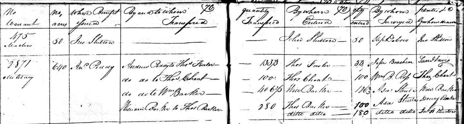
Looking back to an earlier post, Andrew Peddy and Joseph Cobb of Wake County bought into a military land grant of 5000 acres issued for the service of Capt. James Emmet of the North Carolina Continental line. The land was situated in Bedford County along the Elk River located in southern Tennessee. Likely purchased as an investment, Andrew Peddy sold his share of this land after purchasing entitlement to 640 acres to the north. Concerning that purchase, in 1808, Andrew Peddy of Wake County received warrant # 2871 for 180 acres situated in Hickman County, Tennessee. Situated on Tumbling Creek of Duck River, the land was later subdivided in part to Thos Fowler, and then William Barker. Drawn by Drury Barker, William Barker assigned part of the land to Thomas Barker. One corner of that tract is situated “above where said Barker lives.” And in the same year and found on the same page in the land register book, William Barker is recorded as being assigned 100 [additional] acres of Anderson (Andrew) Peddy’s Warrant # 2178. Related title information from the land registration book follows:
Again in 1808, a person named Drury Barker entered 50 acres in Hickman County situated on Garner’s Branch of Piney River joining Lewis Barker’s 62-acre occupant claim. FYI, occupant claims were made by people who actively lived on unclaimed land. This is important because in 1807 Logan County, Kentucky, West Maulding stated Thomas Barker, his father-in-law, lived in Dickson County at that time. Also in the same year, being 1807, Hickman County was formed from Dickson ….hence a workable title history connects Thomas Barker of early Robertson, Tennessee and Logan, Kentucky, a bit further west to Dickson County, Tennessee which later became Hickman.
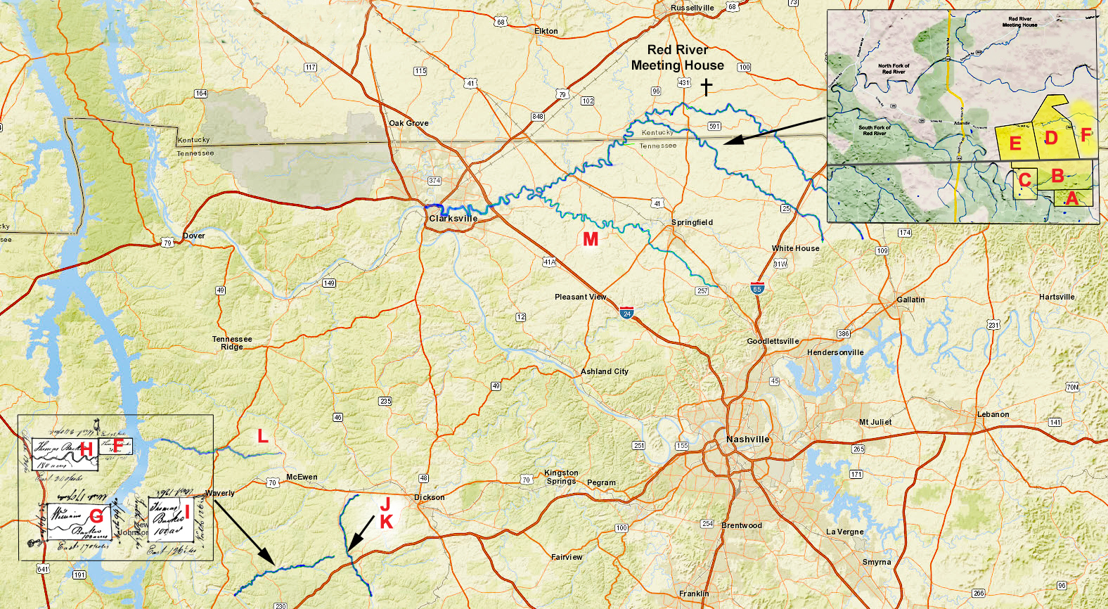
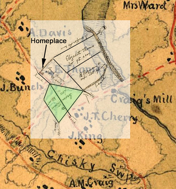
Advancing movements westward in Tennessee, please look at the following timeline. Note that my accompanying platting is meant to give the reader an idea of location and should not be considered exact in locating family homeplace.
Thomas Barker [assignee of Solomon Howard], 15 Sep 1787, warrant 228, Davidson County, being 220 acres on the south fork of the Red River. This tract fell into the newly formed Robertson County which formed in 1796 from Tennessee County which formed 1788 from old Davidson County, North Carolina. CC: William McKadow, James Drumgole.
Lewis Barker [assignee of Samuel Griffis], 14 Oct 1802, warrant 203, Tennessee County, being 400 acres in Tennessee County west of the Cumberland Mountains on the Red River and joining the state line, McAdow, and Thomas Barker.
William McAdow [assignee of Joshua Adcock], surveyed 11 Jul 1785, warrant 701, Davidson County, Tennessee being 274 acres on the south side of the Red River near the rocky spring and the Barrens. CC: Daniel Flanary, Thomas Barker.
John Powers of Robertson Tennessee to Lewis Barker of same, (Deed A1-568, Logan KY), being 200 acres in the fork of the Red River, joining Thomas Barker to the west and Solomon Perkins to the east. Wit: Nathaniel Lacy, William McAdo.
Thomas Barker of Robertson TN to Alexander Gordan of Logan, (Deed A1-578, Logan KY) being 200 acres in the Forks of the Red River in Logan County and joining the state line. Granted to the said Thomas Barker by the State of Kentucky 13 Aug 1797. Wit: James Gimbill, Edma Wilcox, Michael Troubough.
Thomas Barker [assignee of Spilsby Tribble], 25 Jun 1808, warrant 1870, Hickman County, TN, being 30 acres on Tumbling Creek of Duck River, near said Barker’s land. CC: John McKinney,
William Barker [assignee of Andrew Peddy], 24 Nov 1808, Hickman County TN, being 100 acres on Tumbling Creek of Duck River west of Thomas Barker’s northeast corner of his 100-acre tract including where John McKinney lives. CC: James Mc Kinney, John McKinney, William Wyatt.
Thomas Barker, [assignee of Andrew Peddy], 24 Nov, 1808, Hickman County, Tennessee, being 180 acres on Tumbling Creek of Duck River, west of said Barker’s 30 acre entry. CC: John McKinney, William Wyatt.
Thomas Barker [assignee of the heirs of Benjamin Pender], 24 Jun 1808, warrant 2871, being 100 acres joining Thomas Barker’s northeast corner including where John McKemmie lives.
Lewis Barker [Assignee of Robert Weakley], 10 Jun 1809, warrant 96, West Tennessee, being 200 acres on Garners Creek including where sd. Barker lives and adjoining the lands of Benjamin Holland. [Note: ] CC: Young Barker, Samuel Haliburton.
Lewis Barker to James Alston, (Deed A-139, Hickman TN). Wit: William Wilson, Allen Barker.
Drewery Barker [Assignee of Wm. T. Lewis], warrant 928, Hickman County, being 640 acres on Garners Creek of Piney River adjoining Lewis Barker’s Occupant claim. This entry was removed Mar 1810 by Drury Barker.
Lewis Barker [assignee of the heirs of Benjamin Shepperd], 30 Jan 1817, warrant 1683, being 8 acres of sd. Shepperd’s 640 acres in Humphreys County joining said Barker on the Deer Creek, a fork of Richland Creek. CC: Young Barker, Allen Barker.
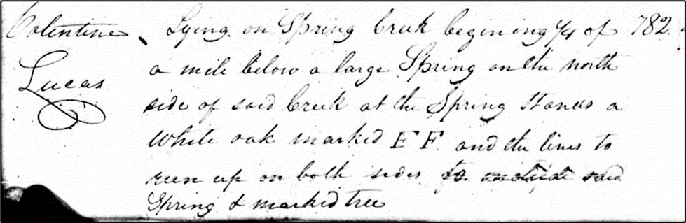
Valentine Lucus, warrant 782, surveyed 24 Jul, being 228 acres on Spring Creek ¼ mile below a large spring.
Thomas Hampton to Minos Cannon of Guilford County NC, being the same land issued to Valentine Lucus (Deed A-76, Montgomery TN), 16 Aug 1791. Minos is father of Newton Cannon who was governor of Tennessee from 1835 to 1839.
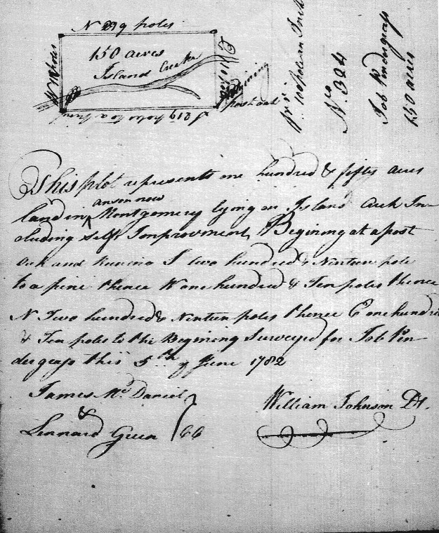
By virtue of a dedimus from Logan County, Kentucky, in 1802, justices Andrew Peddy and Augustus Turner in Wake County, North Carolina, took depositions from Lewis Barker, Mark Barker, Thomas Hogson, and John Utley of that place. From my last post, John Utley in Wake County received a land grant for 300 acres, “being one half of a survey of land formerly made by Thomas Barker.” Furthermore, Mark Barker served as chain carrier for John Utley’s land grant for which the survey happens to locate “Tom Barker Branch.” All records hint that Thomas Barker on Red River TN is the same person though solid proof remains elusive. Furthermore, burning in the back of my mind, Joseph Thomas, and others in 1772 Wake County testified in a suit involving Henry Day and Joseph Cobb who both eventually disappear from the county. I’d like to know more about Henry Day though for Joseph Cobb, a deed filed in the County of Wake states that the said Cobb moved to Washington County TN, where I believe he ended up living with kinfolk who had already made the move west. If so, the family was well off as their home served for a time as the residence of William Blount, Governor of the Southwest Territory. But hidden within the grandeur, Washington County was once the home of another fellow named Thomas Barker …and others. The following is immensely curios though is it possible this is the same Thomas Barker named in John Powers’ letter?
Dated 22 Feb 1779, Washington District (Tennessee) court records identify a person named Thomas Barker who at that time was charged for the serious crime of treason. “On hearing the facts, the court ord. [ordered] discharges.” The case appears to have been dropped though the American Revolutionary War was heating up and soon Britain’s southern campaign would be felt throughout the region. It was in this setting that the family of frontiersman John Sevier found home in the Watauga Settlements along the Nolichucky River. In early October 1780, Sevier was called upon to lead over 600 Overmountain men from the Washington district to face a Loyalist militia commanded by British Major Patrick Ferguson at the Battle of Kings Mountain, South Carolina. The American victory was pivotable and in returning to the mountains of now-Tennessee, a court entry appearing one month later offers a damning assessment:
“Nov 1780, Ord. that the Commissioners advertise and sell the properties of James Crawford and Thomas Barker, the sd. Crawford and Barker being found and taken in arms against the State. “
The above is found online in The King’s Mountain Men, written by Katherine Keogh White in 1924. Katherine offers the following explanation for the court order:
(They were going to hang the said Crawford and Barker right after Kings’ Mountain battle, but Col. Sevier interceded for them and saved them.) John Sevier, Commissioner for 1781 made return that he sold two slaves that was confiscated from the estate of Thomas Barker at the price of thirty four hundred pounds and that he has the money to render unto the court.)
Of all things, it is noted that two slaves confiscated from the estate of Thomas Barker fell into the hands of Col. Sevier. Legally correct, following the war, properties of known Tories were confiscated and sold anew to fray the expenses realized in building the new nation. And mentioning “the estate of Thomas Barker,” did the said Thomas Barker in Washington County, Tennessee die in the period following the battle and before the court entry in November 1780 as indicated? If so, and merely supposing, this cannot be the same Thomas Barker who, with wife Ann, is central in John Powers’ letter concerning the enslavement of free people of color from Wake County. Furthermore, a list of soldiers serving at the Battle of King’s Mountain names Charles Barker, Edmond Barker, Edward Barker, Enoch Barker, Henry Barker, Hezekiah Barker, and Joel Barker. Most of these men can be found in records of nearby Washington County in the state of Virginia.
But here, in Washington County, Tennessee, two “Slaves” from the estate of Thomas Barker ended up in the possession of John Sevier. How very odd as twenty years later the same sort of scenario would occur again per John Powers’ letter. And yet, if that’s not enough to make one take notice, my jaw dropped in reading the following entry which appears in August 1782 Washington County, Tennessee:
“The Court Order that Mrs. Ann Barker wife of Thomas Barker who stands charged with joining the British was taken at Kings Mountain a prisoner, by the Americans after that his estate was Confiscated by the County Court of Washington— On her application in behalf of her Husband for Tryal by Jury the same is Accordingly Granted.”
Ann Barker? Shazaam! And yet, in the 1897 book Dropped Stitches in Tennessee History written by John Allison, Thomas Barker is romantically painted as being a noted Tory, one who took sides against his fellow mountaineers. By rights Thomas Barker should have been hung though his life was spared through his friendship with John Sevier. From the book:
“…Barker was released on his own recognizance, and never tried. Ruined in fortune, ostracized by friends, broken in spirit and in health, he could not endure his changed condition in life. He died soon after his release from prison, and the brave, faithful, noble but broken-hearted wife speedily followed her husband to the grave.”
The author tells of a little graveyard and of how memories had nearly disappeared. The writing is wonderful, and I ask folks to take a minute to page search for Thomas Barker. Don’t you think the narrative goes beyond what can be proven? It does appear in word that Thomas Barker died though could the mentions of his estate being confiscated refer to a banishment from his home in Washington County?
Could this be Thomas Barker, the son of William and Priscilla as proven in John Powers’ letter? Such a person could have maintained connections to his home in North Carolina and the details certainly align with the narrative as is revealed by John Powers. This Thomas Barker could also have gone west to the Yadkin and travelled beyond to the Western flanks of the Appalachian in Washington County, Tennessee. He could have served in the war, …maybe not the best choice of wording. And upon committing treason, he and his wife could easily have been banished though free and goodly people indentured to him suddenly had their lives redefined. Thomas and wife Ann Barker could have later moved further west to Robertson County, Tennessee and to Logan County, Kentucky. Could such a scenario have happened?
Looking closer at Washington County, in 1779 Thomas Barker received 100 acres on the north side of Nolichucky River “including the plantation whereon he now lives.” The next entry is for 200 acres to John McAdow on Ballard’s Creek below Barker’s Bottom and —- upon both sides including said cabbin.” About the same time, in September 1779, William Pruitt entered 640 acres for Col. John Sevier “on the north side of Nolichucky including Thomas Barker’s improvement.” In March 1778, Wm. McAdoo received 200 acres on the south side of Nolichucky River “above Barker’s Bottom.” He received another 200 acres on the opposite side of the river where Barker’s path crosses Sinking Creek.” Furthermore, in 1782 a person named Benjamin Holland received land nearby on Sinking Creek. Is this the same William McAdoo who later lived beside Thomas Barker in Robertson County, Tennessee? And, is Benjamin Holland living nearby somehow connected to Benjamin Holland who lived near the Barker family in Hickman County, Tennessee? There must surely be other connections which I believe warrants further research.
At the end of the day much remains uncertain concerning the Barker family as records reflect their move west. As quick as I am able to place members following the migration into a tree, I find something new calling into question thoughts I had just placed on paper. The following trees reflect my thinking based in part on research efforts by others. The illustration will hopefully garner reader push-back opening my eyes to thoughts I had not considered.
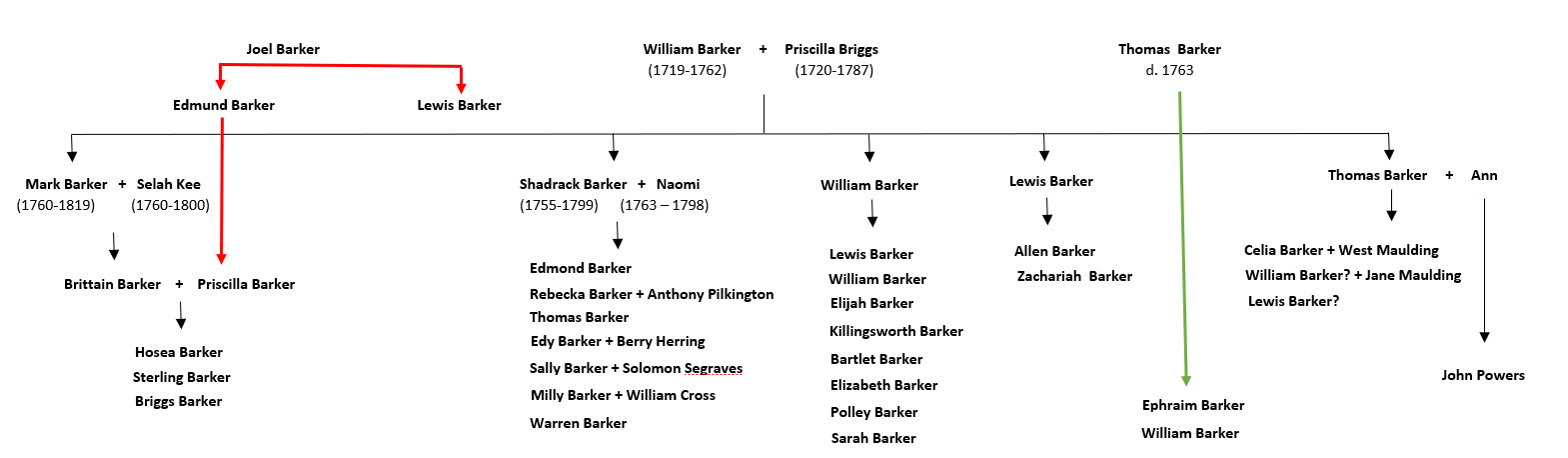
Before leaving this subject, I’d like to share two well-dispersed documents I’ve only recently come to see. First, a legal issue connecting family in Tennessee to the 1815 estate of Edmond Barker in Wake County, North Carolina rose to the level of the Supreme Court. Take time to read the case report and make sure to click on Larger Image Available. The documentation clarifies a bit of the family tree while connecting the descendants of Edmond Barker and Lewis Barker. Note that descendants of Edmond Barker sold the enslaved Rachael to Zachariah, believed to be the son of Lewis Barker. And further note that a person named Young Barker served as representative for the sale. Young Barker also served several times as chain bearer on behalf of Lewis Barker’s early land grants in Hickman and Humphreys Counties, Tennessee. And looking back to Wake County, Barker family, mostly in Tennessee, believe that Edmond Barker is the son of Joel Barker who I have not written much about. Exact relationship between the elder Joel Barker and William and wife Priscilla Barker is unknown. However, note that Joel’s will does appear in 1779 Wake in which he names sons Edmond and Lewis …hence the relation is believed to be established.
Looking closer at records in Wake County, dated 12 Jan 1805, Edmond Barker sold to Lewis Barker 990 acres (Deed T-106, Wake) “situated on the waters of the Great White Oak Creek (which land was formerly the property of Shadrich Barker, dec’d), who was the father of said Edmond, also the use of the plantation where Edmond Barker now lives for the term of six years” Witnesses were And’w Peddy and Mark Barker. Rather than being the son of Joel Barker as believed by some, it is my belief that Edmond, the one who died ca. 1815, is the son of Shadrack. Brittain Barker above would have married his first cousin’s daughter Priscilla if I am correct. Furthermore, the young Priscilla Barker came by her name rightfully since both hers and her husband’s fathers are proven (per the 1804 letter) sons of William’s Priscilla. There would be no such need for honoring through the family of Joel Barker. ….just a thought.
Lastly, the Barker family met all kinds of folks in their move west from Wake County. Certainly, there were outlaws and pirates first camp meeting leading to the Second Great Awakening. One daughter’s husband fought the Indians and was laid to rest by the young Capt. Abraham Lincoln. The families hunted bear and pulled bullets from trees …and they operated a ferry. They faced off against the Governor of Tennessee and yet little would be known if not for a family once free who were later enslaved. Amazing stuff! But before closing, I’d like to tell of one more eye-opening connection to the family and to those who settled our west.
One last story. Along the waters of White Oak Creek, Seth Utley was born the son of Burwell Sr. and Sarah Lashley Utley on 7 Oct 1789. Ca. 1817 he, “along with two of his brothers, Able and Burwell, emigrated to Reynoldsburg, Stewart County (later Humphreys County), Tennessee.” They followed their Uncle Burwell Lashley. Note at this point that Seth Utley’s grandfather was John Utley, the same as he who testified in the 1804 letter written by John Powers.
Following 1835 teaching by Mormon missionaries (probably Patten and Parish), Seth became a pillar of the small Mormon community at Eagle Creek in Benton County, Tennessee, one of the first branches of the church in Tennessee. Then:
“On 19 June 1835, while Elders Patten and Parish and were staying at the home of Seth Utley, a mob of about 40 gathered around the Utley home. The sheriff produced a warrant for their arrest. The warrant was written on the urging of a local Methodist minister name Matthew Williams on the charge of making false prophesies. Seth Utley and Albert Petty put up the required bond of $2,000.
After a trial in which they were not allowed to testify or bring witnesses, they were declared guilty by the judge. Ultimately Elder’s Patten and Parish were told the case would be dismissed if they agreed to pay the court costs.
After they were released, they went back to Seth Utley’s home. When they arrived, they heard that a mob had gathered again angry that the missionaries had been released. Mounting their mules, they took a back route to Albert Petty’s home where they went to bed. They had not been asleep long when Elder Patten woke up Elder Parish, telling him that a heavenly messenger had warned him that the mob was near and that they should leave. When the mob arrived, the Elders had already left. But it was morning before they found the mule tracks. By then the Elders were long gone.”
Seth Utley was not the only one from earlier in Wake County who followed the Mormon teachings as in 1835, Wilford Woodruff “Rode to Lewis Barkers. Preached at his hous. Br Parrish Baptized 2 persons. Distance 6 miles.” And being the Forth President of The Church of Jesus Christ of Latter-day Saints and founding father of the Mormon Academies, Wilford Woodruff made numerous missionary trips through Tennessee of which Lewis Barker’s home was a frequent stopping point. Recorded far differently from what I could have imagined, folks from Wake County added substantially to the story of how the west was won.
While looking into early communities in southwest Wake County, I came across sizeable numbers of people who migrated to Middle Tennessee before moving north and further west. Among those removing to Tennessee was a person named Thomas Barker who some say descends from George Barker from earlier in Wilkes County …in the foothills of western North Carolina. I don’t think that is the case as this fellow’s record clearly connects him to apparent family in Wake County ….in central North Carolina. The most plausible beginnings for this person in Tennessee can be found in the person named Thomas Barker who died in a section of eastern Orange County before it became Wake in 1772. Timing and community clearly connect Thomas Barker in Tennessee to this person, though there is a problem. Any attempts to tell the story of Thomas Barker in Tennessee fails due to how we interpret the death records referencing the pre-Wake County death of Thomas Barker who lived in that place. The story though is wonderfully interesting, offering twists and dilemma making it quite tenuous for one to establish a specific link from Thomas Barker of Tennessee to his ancestor here in North Carolina.
Furthermore, and by way of testimony brought to life in an astounding letter published in 1804 Nashville, Tennessee, the story of Thomas Barker merges with that of others, including a Free Person of Color named Mary Locust. The letter at the heart of this post tells of injustice, of citizens here in Wake County who later were wrongfully enslaved in Tennessee. The letter speaks of evolving cultural realities, power, and its abuse.
As how best to present the said Thomas Barker/s in context of the cultural realities, I believe it is important first for the reader to have time to digest the pleafully written epistle before going forward. Read it and maybe let your thoughts ruminate a while before delving into my next post which I hope to come out soon. Also, take time to read earlier posts in this series as eventually I hope you will realize it is all connected.
For those with roots in Wake, North Carolina, spreading to Middle Tennessee and even Kentucky and Illinois, I hope this post will offer thoughts worth your consideration on how one should best present stories of families past … our making is indeed built upon a mix of realities, both good and bad. Please feel free to similarly add your own thoughts concerning others who trekked west from Middle Carolina to Middle Tennessee and beyond.
Governor John Sevier
[22 Aug 1804, The Tennessee Gazette, Nashville, Tennessee]
For the Tennessee Gazette.
__________________
To his ExcellencyJOHN SEVIER Esq.
As no doubt, from the exalted station you occupy; from the distinguished confidence your fellow citizens have reposed in you, you must be a just man, and a true republican; I take the liberty of offering to you, through the medium of the public papers evidence sufficient, in my opinion, to convince you, or at least the public, that you do unjustly, and contrary to right, hold in your possession, and detain in slavery, a certain woman of color, by the name of POLL LUCOST [Lucas], with her three children. I will not suppose that you have determined to hold them against right, and rely upon their inability to defend themselves, as the security for your tenure; because this I think, would be an imputation upon the honesty and generosity of a man who has been too much distinguished by public approbation, not to have secured him against suspicions of this kind. In a land of liberty, surely nothing can be more unnatural or unjust, than to deprive any person of that liberty to which they are by law entitled; and so careful will every man be, who is attached to the principles of justice in general, and our government in particular, that if even a rational shade of doubt should exist, as to his right in such case, he would abandon it in favor of the liberty rather than run any risqué of practicing and oppression upon a poor helpless, destitute, ignorant, and impotent woman, with her children. This defenseless situation, rather than invite a disposition to wrong and oppress in a noble and generous mind – in a mind as little contaminated by fraud and avarice, as I would wish to consider yours, the highest sensibility, fortify it against any subtle insinuations of avarice, and impel it to the highest generosity, and the most distinguished justice -Surely you do not wish to be made to do right by the law: there will then be no more in it: the law was only designed to operate upon those over whom a sense of justice had no influence; therefore I infer, that all that is necessary with governor Sevier, is to satisfy his mind that those people are not slaves: for which purpose I offer you the following evidence: if it satisfies you that they are free-born, is it not unjust in you to keep them in slavery? And will you ever suffer it to be said that the aid of law was necessary to compel the chief magistrate of Tennessee to do a common act of justice, or to restrain him from the commission of a most palpable injustice, and acting in direct and open opposition to those laws which he has sworn to see faith fully administered; and those principles of republicanism which he professed to adore. If this evidence does not satisfy you, I have in my possession more, which shall be at your service, if you are disposed to enquire after truth, in order to ascertain the claim of these people to your justice. If, on the other hand, you are determined to hold these people, right or wrong, I confess you have it completely in your power. They are friendless; the voice of humanity and justice is too feeble to call forth the energies that are necessary to contest in a tedious lawsuit with a man possessed of the great personal influence of the governor of Tennessee; and if your mind is capable of assenting to the availing yourself of the powers and influences which your more happy fortune has given you the advantage of; you can do so. But with this evidence, the noble and generous mind, which should always accompany, and be possessed by a man in your station: when reasonable doubts are suggested of your right to this property, ought you not, instead of relying on their inability to support their claim, to be yourself active in investigating your right (not your power) to detain them? For my part, having been raised in the same family with Poll Lucust, from infancy to manhood, and well knowing her justly entitled to her freedom, when I found you determined to keep her as a slave – I caused a suit to be instituted against you, at Jonesborough, about three hundred and sixty miles from my house: being a poor man, and unable to attend at such distance, and defray the expenses of the fruit; and not having it in my power to obtain from the friends of humanity the necessary assistance, I shall be constrained to leave these unfortunate people to their cruel destiny, or to your just sense of justice.
In order that the evidence which I am about to offer to you, may be understood, it may be necessary to premise a few things: –Mary Locust was the mother of Poll Lucust, Val Lucust, and Austin Lucust. Mary ever passed as a free woman till she bound herself by indentures, to Thomas Barker, for seven years, in consideration of the payment of twenty-one pounds by said Barker, for her use; which indenture I have in my possession. Val [Valentine] Lucust lives in North Carolina, as a free man, no body pretending to set up any claim to him. Austin Lucust lives on the waters of Holton, as a free man, and purchased his wife, who you know belonged to your excellency; and it is also known by you, that no body pretends to exercise any ownership over her, and two of her children. Your example in detaining Poll and her children, has had a very fatal effect in Logan county Kentucky, where three of Betsey’s children are held as slaves, under Wm M’Ado, who publicly, in Robertson county court, at two different times, acknowledged their freedom and had them bound to him as poor orphans as may be seen in No. 1. This shows the great impropriety, and pernicious tendency of evil example, in persons as illustrious as you are. I cannot pass on to detail, without making in this place, one reflection; it is surprising that two brothers and a sister of Poll should be enjoying their freedom, and yet Poll be a slave! Where particularly, it never has been pretended that any manumission has taken place; and it is a circumstance that ought to be accounted for to your mind! The evidence which now offer, has been legally taken, in a suit in Logan circuit court, wherein the question of freedom was involved. Thomas Barker, had Betsy, Poll, and Austin in his possession, and the following deposition accounts for that possession. By law, hearsay and reputation are good evidence of pedigree: 2 Esp. 723, Buller et P. 233.
_____
Certificate No. 6, will be read as No. 1
No.2, 3, 4, and 5, are depositions taken by Andrew Peddy and Augustus Turner, of North Carolina, by virtue of a dedimus from Logan circuit court. All that applies to Betsey Lucust, with respect to her freedom, applies to Poll, or Mary, her sister, in your possession.
No. 2. The deposition of Lewis Barker – He deposeth and saith, that he knew an old woman of color, by the name of Mary Lucust, and that she went from Wake county with his brother, Thomas Barker to the Yadkin river, where he saw her sometime after, and that she formerly lived with his mother, and ever passed as a free woman; and that he has seen to of the old woman’s daughters by the name of Mary Lucust, and Betty Lucust –and that there is not living, one of the old woman’s sons in the county of Wake, by the name of Val Lucust, and all of them ever passed as free persons; and that he never heard anything but that they were free people. Signed with his name.
No. 3. The deposition of Mark Barker – He deposeth and saith, that he formerly knew a certain old woman of color, by the name of Mary Lucust, who formerly lived with his mother, and passed for a free woman; and that he has seen the old woman’s two daughters, Mary and Betty, living on the Yadkin River, with his brother Thomas Barker, and they still passed as free. Signed with his name.
No. 4. The deposition of Thomas Hogson – He saith he knew a certain old woman of color, by the name of Mary Lucust, about forty years back, and that she ever passed as a free woman: that she removed from the county of Wake, with Thomas Barker, to the Yadkin river, as a free woman: this deponent farther saith that he is well acquainted with a son of said old woman’s, by the name of Val Lucust, who us now living in the county of Wake, not exceeding twelve miles from him, and he has ever passed as a free man, since his apprenticeship was done, and that the said old woman’s mother was said to be of an Indian race, and that he never heard anything to the reverse, but what they were free. Signed with his name.
No. 5. The deposition of John Utley –saith he was well acquainted with a certain old woman, by the name of Mary Lucust, for forty or fifty years back, while she lived with old Mr. William Barker, father of Thomas Barker, with whom she removed from the county of Wake to the Yadkin river, and that she ever passed as a free woman; and that she had five sons, who enjoyed the privilege of free citizens, the years of minority, and that he never heard anything to the reverse, but what they were a free people. Signed with his name, and take in due form of law, 3d September, 1802, by the justices aforesaid.
State of Kentucky –
Logan Circuit, to wit:
I, Armistead Morehead, clerk to the Logan circuit court, to certify, that the foregoing depositions are copies of those filed in my office, in the suit wherein James Moses, and Austin Lucust’s are plaintiffs, and Morton Maulding defendant. Given under my hand this 21st day of February 1804.
Armistead Morehead.
Agreeable to a commission from the quarter-session court of Logan county, to us, West Maulding, and Richard Boyce, justices of the peace for Logan county, directed, we have called, and caused to come this day before us, here, that is to say, 30th June, 1802, at the house of Clayton Talbot, in the town of Russellville, in Logan county, Thomas Barker, Anne Barker, his wife Celia Maulding, and John Powers, the witnesses in said commission named, as in the said commission it is commanded us, who being by us first swear the truth to say, in a certain matter of controversy in the aforesaid court depending and undetermined, wherein Ninian Edwards is plaintiff, and Morton Maulding defendant –an action of detinue, deposeth and saith as follows, to wit:
No. 6 &1. Thomas Barker deposeth and saith, that he is in no wise interested in the event of the above fruit; and this deponent farther deposeth and saith, that he was well acquainted with a certain Mary Lucust, who was the mother of Elizabeth, or Betty Lucust, which said Betty is the mother of James and Austin Lucust, and that the said Mary Lucust, so long as this deponent was acquainted with her, which was about forty years, always passed for a free woman, and that he never heard of her freedom, as to birth, being disputed by any person, and this deponent farther deposeth and saith, that the said Mary voluntarily indentured herself to him, for the space of seven years, in consideration of the payment of twenty-one pounds, by, this deponent, to the use of the said Mary; and the said Mary died before the expiration of the said term of seven years; and this deponent farther saith, that he never held said Mary as a slave, any otherwise than by the indenture aforesaid.
Question by defendant –Was Mary Lucust white or black?
Answer –She was neither white nor black, but of mustac color.
Q by deft. Is said Betsy Lucust mother an Indian or negro.
Always reported to be an Indian.
by the deft. Is said Betsy Lucust the daughter of the aforesaid Mary Lucust, or not?
Said Betsy was always reported to be the daughter of said Mary; and I knew said Betsy from the time she was only eight or ten days old, and she sucked said Mary, until weaned at a coming of age, and I believe said Betsey to be the child of said Mary.
by pltt. Mr Barker, did you ever give the aforesaid Betsy Lucust to a certain William M’Ado, or not?
I did not.
by plff. Did you give her to William M’Ado’s wife, or not?
I did not.
And farther this deponent saith not. Signed, & c.
No. 7. Anne Barker, wife of the aforesaid Thomas Barker, deposeth and saith, that she was well acquainted with the above said Mary Lucust for the term of eight or ten years before she died, and that she the said Mary was generally supposed to be a free-born woman, and to have come of an Indian Squaw; and that she never heard of her freedom as to birth, disputed during her, said Mary’s life and that the aforesaid Betsy Lucust is the child of the aforesaid Mary : that this deponent was present at the birth of the said Betsy; and this deponent farther saith, that James, Moses, and Austin Lucust, infants, now said to be in the possession of Morton Maulding, is the children of the aforesaid Betsy Lucust, to the best of her belief, from the following circumstance, to wit: that she was present at the birth of said Austin, and was sent for a midwife to said Betsy Lucust, when the aforesaid James Lucust was born but did not arrive until the child James was born, and said Betsy put to bed; and the three children, to wit, James, Moses and Austin Lucust, sucked said Betsy until weaned at common age; and farther this deponent saith not. Signed, & c.
No 8. Celia Maulding, daughter of Thomas Barker, the 3d witness named in the aforesaid, deposeth and saith, that she knew nothing of her own knowledge, about the mother of the aforesaid Betsy Lucust, only from hearsay; that she always heard her parents say, she, the said Betsy Lucust, was free born, and that her mother, Mary Lucust, lives some time with her parents, and died in her father’s family; and that said Betsy Lucust was always considered to be a free born woman, and she never heard of her mother’s being a slave; and farther this deponent saith not. Signed, &c.
No. 9. John Powers, son of Mrs. Thomas Barker, the 4th witness named in the above commission, deposeth and saith, that he was well acquainted with the above said Mary Lucust, until she died, and that he never heard her freedom as to birth, disputed by any person; and that the above said Betsy, always passed as the child of said Mary, and was always considered to be a free woman; and that the aforesaid James, Mote and Austin Lucust, infants, now in the possession of Morton Maulding, is considered to be children of said Betsy; and farther this deponent saith not. Signed, &c.
We, West Maulding, and Richard Boyce, do certify that the above depositions were sworn to and subscribed before us, this 30th day of June, 1802.
West Maulding, J. P.
Richard Boyce, J. P.
A copy. Teste, Armisted Morehead
The printers at Knoxville and Jonesborough will do a friendly act to the unfortunate sufferers, by publishing the above in their respective papers, before the setting of the superior court at Jonesborough. J. P
Ascertaining genealogy from John Powers’ letter is nearly impossible. Reading the above is like following a rapidly moving marble gliding among cups in a trickster’s well-played shell game. Just as with genealogy, the key to winning the game is one of keeping your eye on the ball and yet, only seeing bits of information spread through time, one may never be able to reconstruct and therefore determine where the moving ball ultimately ends up. However, not only does John Powers’ letter provide a wonderful glimpse into matters of race during early North Carolina, it also adds substantially to the Barker family story …if only I could figure it out. Exactly who was Thomas Barker and as for John Powers, why can I not find him earlier in Wake County in connection there with the Barker family? Before moving forward, please take a minute to study the following, which illustrates the relations of all those named in John Powers’ letter.
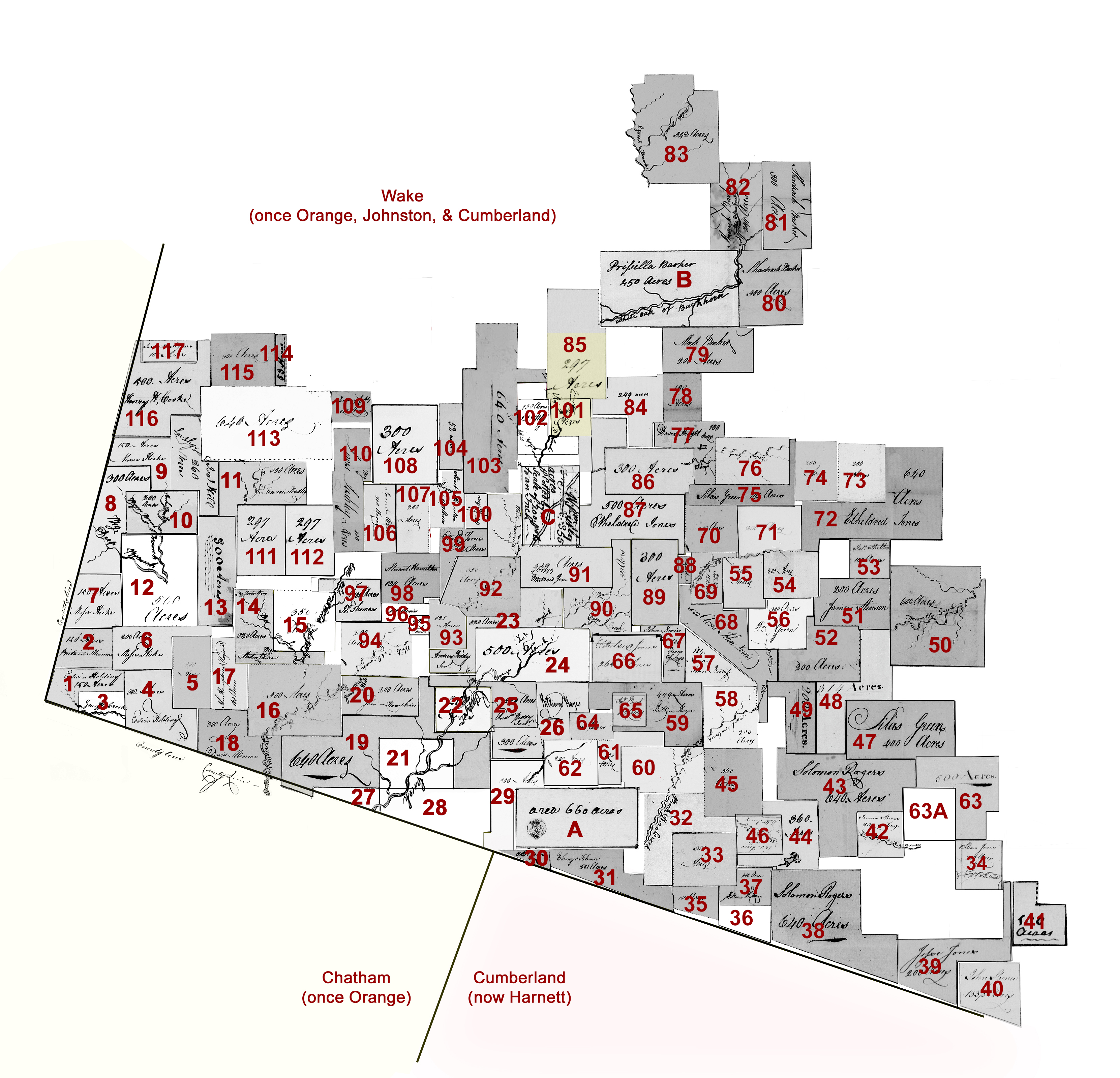
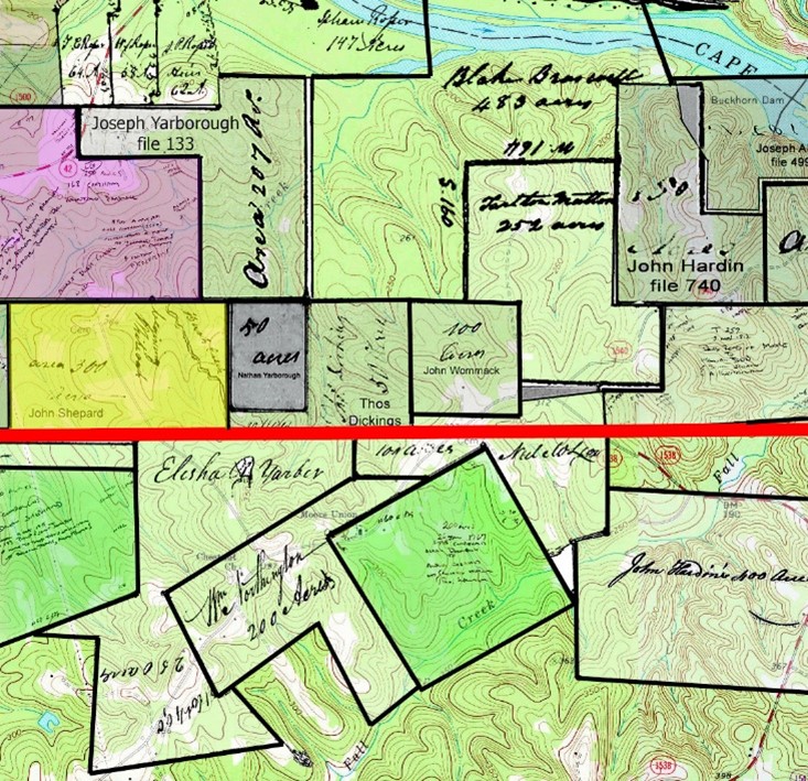
New finds lead me to increase the size of community I am studying in southwest Wake County. The following map was created using survey plats and descriptions gleaned from original land grants housed at State Archives of North Carolina. Please do not expect this to be perfect as any attempt to reconstruct land histories is fraught with inaccuracies, often arising from differences in interpretation. I studied the early paper-based Marcom map housed at Olivia Raney Library and have filled in a few gaps and even made a few changes. I’m sure others will come along and do the same considering this small project was pulled together in a few weeks. Any thoughts are welcome!
This map and its key below should provide researchers the chance to imagine this place and community of people where their ancestors once lived. I begin with a few early Granville grants predating Wake County. Following that are North Carolina Secretary of State land grants issued for land in Wake County. To see the legal descriptions and survey plat all one needs to do is enter the corresponding file number and county into the nclandgrants online query search.
Granville District Grants issued between 1748-1763
by John Lord Carteret, second Earl Granville
To see each original document, go to nclandgrants.com and type in the county name and the corresponding State Archives of North Carolina file number.
[note: CC is an abbreviation for Chain Carrier]
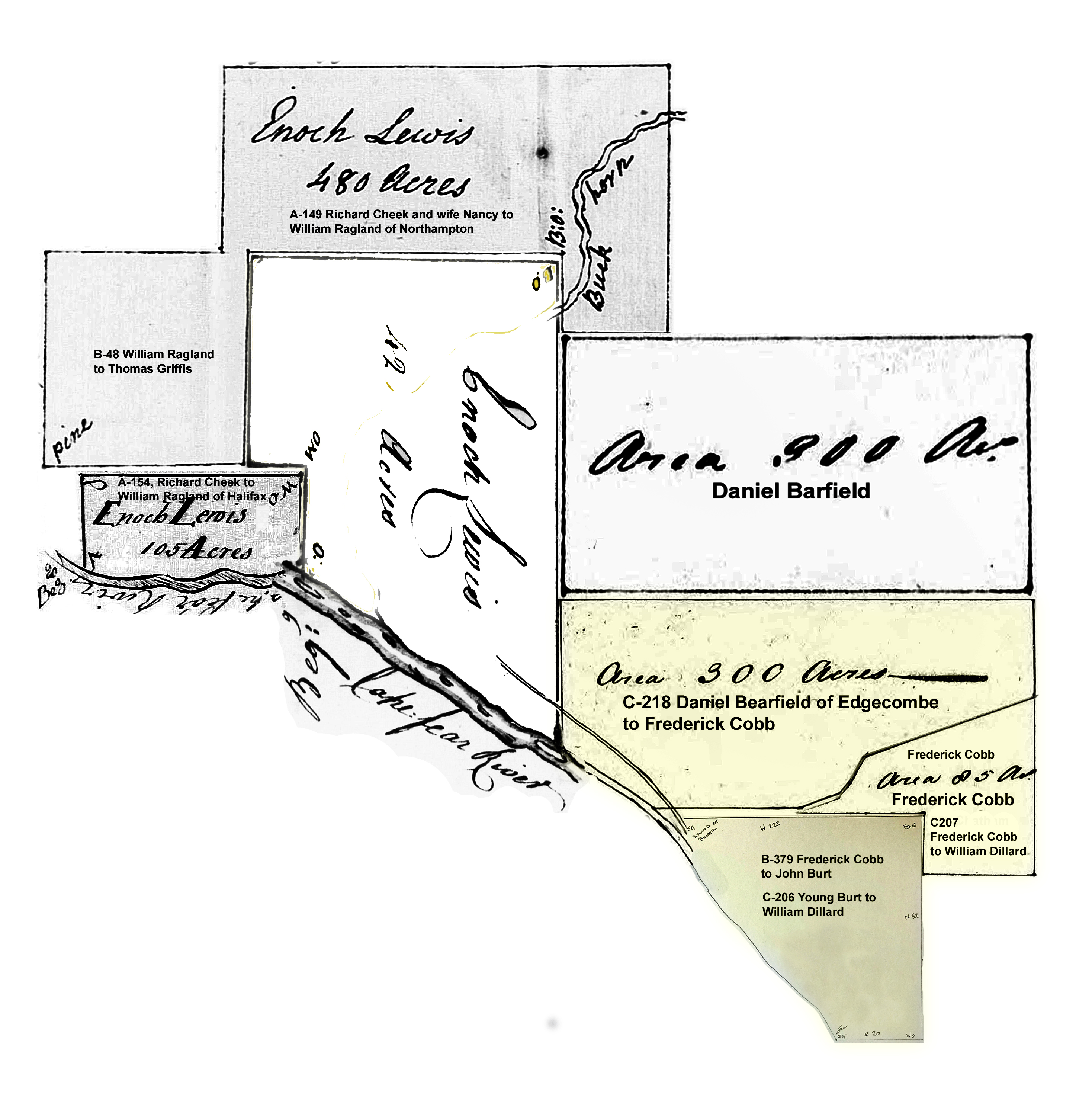
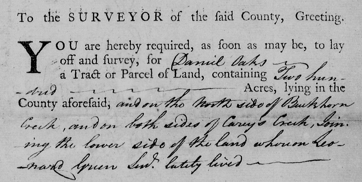
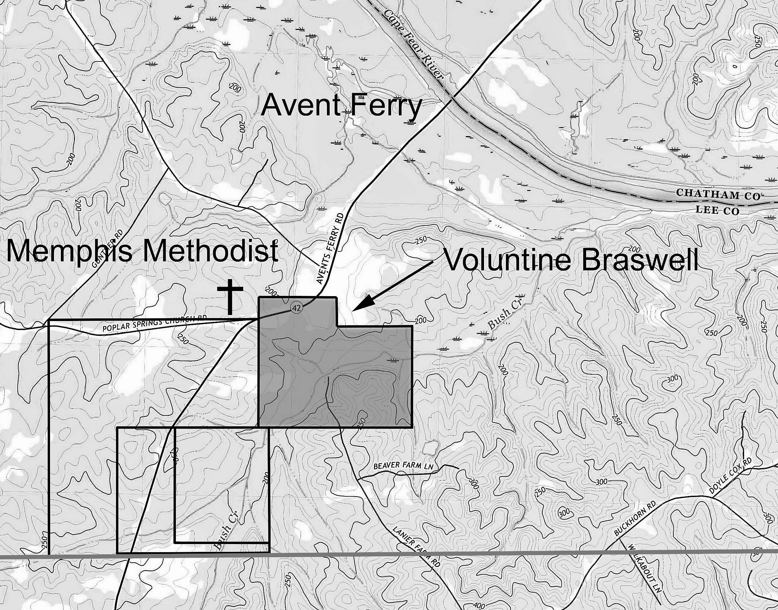
A. Richard Hill, file #48 Cumberland, issued 1 Apr 1763, being 660 acres on both sides of Buckhorn Creek CB: Robert Reivers Jones, Thomas Broom. (This land is in present-day southern Wake County indicating it was in a portion of the county originally formed from Cumberland to the south).
B. Prissilla [Priscilla] Barker (Executrix of William Barker Deceased), file #335 Orange, issued 6 Dec 1761, being 450 acres on Buckhorn Creek. CB Tho’s Barker, Edward Hobson. Metes and bounds indicate this tract adjoined Thomas Barker’s land to the south. (This land is in present-day southern Wake County indicating it was in a portion of the county originally formed from Orange to the west.
B+ Thomas Barker (shaded yellow), file #01136 Orange, entered 2 Sep 1761, being 700 acres on White Oak Swamp beginning on William Utley’s line. (Any file number beginning with zero indicates a grant may have been entered though for some reason it never matured and was issued. Perhaps the 700 acres incorporated or was at least adjoining the land of Priscilla Barker.
C. William Utley, file #16 Orange, issued 21 Jan 1761, being 335 acres on White Oak Swamp. CB, Jesse Lane, Joel Lashley. (This land is in present-day southern Wake County indicating it was in a portion of the county originally formed from Orange to the west.
North Carolina Secretary of State Land Grants
[note: CC is an abbreviation for Chain Carrier]
Edwin Holding, file 1366 Wake, issued 23 Dec 1801, being 150 acres on Tom Jack Creek joining Mimms, Hicks, and the county line. CC: Moses Hicks, Edmund Lashley.
Britain Mimms, file 1363 Wake, issued 17 Aug 1801, being 150 acres on Shattock’s Creek joining Hicks and the county line. CC: Moses Hicks, Edmund Lashley.
Britain Mimms, file 1362 Wake, issued 17 Aug 1801, being 100 acres joining the county line on the north side of Lick Branch. CC: Moses Hicks, Edmund Lashley.
Edwin Holding, file 1392 Wake, issued 18 Feb 1802, being 300 acres on the waters of Tom Jack joining David Mimms and the county line. CC: Moses Hicks, Edmund Lashley.
Moses Hicks, file 480 Wake, issued 11 Apr 1780, being 200 acres on Tom Jack Creek below Thomas Hicks’ improvement, including Moses Hicks’ improvement. CC: Joseph Thomas, Shadrack Brewer.
Moses Hicks, file 1106 Wake, issued 18 May 1789, being 200 acres on Tom Jack Branch, joining his own and Thomas Hicks. CC: David Mimms, Hansel Hicks.
Moses Hicks, file 1365 Wake, issued 14 Nov 1801, being 150 acres (joining Isaac Hill deceased and the county line) …survey mentions Hansel Hicks. CC: Britain Mimms, Edmund Lashley.
Joseph Thomas [assignee of William Olive], file 886 Wake, issued 30 Sep 1785, being 300 acres on the south side of Tom Jack’s Branch joining Moses Hicks, Thomas Tedder, and the county line. CC: Thomas Tedder, William Bugg.
Moses Hicks, file 1502 Wake, issued 19 May 1817, being 150 acres on Tom Jack joining Tedder and the county line. CC: Edmund Lashley, Willis Hicks.
Joseph Thomas [assignee of Thomas Tedder], file 957 Wake, issued 30 Sep 1785, beginning at Thomas Hick’s corner, being 200 acres on Tom Jack Creek and crossing Bugg’s Branch. CC: Isaac Hill, William Bugg.
Francis Bradley (assignee of John Hill), file 1047 Wake, issued 15 May 1787, being 300 acres on Thomas’ Creek joining James Oliver and Isaac Hill. CC: James Olive, Edmund Lashley.
Thomas Hicks, file 476 [A] Wake, issued 11 Apr 1780, being 500 acres on both sides of Tom Jack Creek joining Moses Hicks. CC: Shadrack Brewer, Moses Hicks.
Moses Hicks, file 1291 Wake, issued 10 Jun 1799, being 300 acres on Tom Jack Creek joining John Humphries “Virginia,” James Huckabee, Isaac Hill, and Martin Lane. CC: Jacob Hill and George Talley.
Martin Lane, file 945 Wake, issued 30 Sep 1785, being 350 acres on Bear Branch joining Joseph Thomas and Levin. CC: Etheldred Jones, Silas Green.
Joseph Thomas, file 482 Wake, issued 11 Apr 1780, being 350 acres on both sides of Little White Oak Creek and both sides of Jacob’s Creek, joining James Olive and Levin. CC: Etheldred Jones, Josiah Brown.
Jacob Levin, file 480[A] Wake, issued 11 Apr 1780, being 300 acres on White Oak Creek above David Mimms’ entry and below Jacob’s Branch. CC: Josiah Brown, Joseph Thomas.
John Humphries “Virginia”, file 993 Wake, issued 15 May 1787, being 160 acres on White Oak on Tom Jack Branch joining David Mimms, Moses Hicks, Martin Lane, and a “line formerly called Levins.” CC: Moses Hicks, Hansel Hicks.
David Mimms, file 961 Wake, issued 15 May 1781, being 300 acres on the Great White Oak Creek joining the county line and Jacob Levin’s. CC: Moses Hicks, Hansel Hicks.
Ethelred Jones [assignee of John Norris], file 934 Wake, issued 30 Sep 1785, being 640 acres on the west side of Braswell’s Creek and on both sides of White Oak Creek, joining Jacob Levin, John Humphries, Peddy’s, Daniel Oaks, Phelps Smith, Wommack’s and the county line. CC: John Sellers, John Norris.
John Humphries “Virginia”, file 895 Wake, issued 30 Sep 1785, being 200 acres on both sides of White Oak Creek joining Jacob Levins and Josiah Brown. CC: John Norris, Garrett Stephens.
Felps Smith, file 492 Wake, issued 11 Apr 1780, being on Cary’s Creek, where Samuel Booker now lives. CC: Daniel Oaks, Britain Womack.
Daniel Oaks, file 244 Wake, issued 29 Mar 1780, being 200 acres “on both sides of Cary’s Creek joining the lower side of the land whereon Leonard Green Sen’r lately lived.” CC: Andree Peddy, Jeremiah Peddy.
Andrew Peddy Senr., file 946 Wake, issued 30 Sep 1785, being 320 acres on Cary’s Creek joining his own, John Norris, Etheldred Jones, and Hamilton’s. CC: John Norris, Andrew Peddy.
Andrew Peddy, file 288 Wake, issued 29 Mar 1780, being 500 acres on the north side of Buckhorn being the land purchased by the said Peddy of Leonard Green, including the plantation where Leonard Green Junr now lives. CC: Andrew Peddy Jur, Jeremiah Peddy.
Andrew Peddy Junr., file 920 Wake, issued 30 Sep 1785, being 200 acres on both sides of Cary’s Creek joining Andrew Peddy Senr. and Daniel Oaks. CC: Etheldred Jones, James Sellers.
William Hayes, file 1309 Wake, issued 10 Jun 1799, being 300 acres on Cary’s Branch joining Capt. Thomas Cary’s line. CC: Andrew Peddy, William Gaines.
William Hayes, file 1337 Wake, issued 1 Jul 1800, being 26 acres on Buckhorn joining his own lands and the Chatham County line. CC: Mark Cook, George Nash.
Britain Womack – From granted land in neighboring Chatham County lying in both Chatham and Wake Counties.
Felps Smith, file 484[A], issued 11 Apr 1780, being 300 acres on both sides of Buckhorn joining Richard Hill, “including John Smith’s mill,” and joining the county line. CC: David Jones, Elkin Jones.
William Hayes, file 1310, issued 10 Jun 1779, being 40 acres joining his own lines, James Stephens, & the land called Folsom’s land, and the county line.” CC: Thomas Peddy, ——— Norris
Ebenezer Folsom, file 995, issued 15 May 1787, being 281 acres on the south side of Buckhorn, joining Charles Jones (formerly), Watson’s, Phelps Smith, David Jones, and the county line. CC: Joel Edwards, Frederick Jones.
Peter Quarles, file 1054, issued 1787, both sides of Buckhorn, joining William Jones, Charles Jones, and near David Jones. CC: Joseph Thomas, James Stephens.
David Jones, file 495, issued 1780, being 300 acres on the south side of Buckhorn joining Felps Smith. CC: Felps Smith, Elkin Jones.
William Jones, file #975, issued 1787, being 200 acres assigned to William Jones by Daniel Oldhands. on the Fork of Neals Creek “including improvements made by Jacob Thomas.” CC: Fredrick Jones, Joshua Elkins.
Felps Smith, file 457[A] Wake, issued 1780, being 100 acres on the Waters of Buckhorn, the warrant says on both sides of Horse Branch. CC: David Jones, Phelps Smith.
David Jones, file 0121 Wake, being 50 acres with the “0” in the file number indicating the grant was never issued. The original warrant was for land adjoining his own and the Cumberland County line.
William Watson, file 974 Wake, issued 1787, being 200 acres on Horse Branch, joining Phelps Smith, David Jones, and the county line. CC: John Burt, David Smith.
Solomon Rogers, file 1470 Wake, issued 1809, being 640 acres with warrant mentioning being joined to Nathan Thomas. Survey identifies the land on Hector’s Creek joining Mathew R. Turner, the county line, and David Jones. CC: Darling Jones, James Jones.
Jesse Jones, file 1009 Wake, issued 1787, being 200 acres on both sides of Horse Pen Prong of Niels Creek joining his own line. CC: Mark Myatt, James Lightfoot.
John Spence, file 1293 Wake, issued 10 Jun 1799, being 133 1/3 acres joining Jesse Jones and the county line. CC: Solomon Rogers, Jesse Jones.
William Love, file 1296 Wake, issued 1798, being 100 acres assigned to William Love by Jesse Jones. West side of Neals Creek joining Jesse Jones and William Jones. CC: John Terrialle, Clem’n Stinson.
James Stephens, file 1393 Wake, issued 1802, being 200 acres on both sides of the Gaulberry Fork of Niels Creek. CC: Darling Jones, Redick Stinson.
Solomon Rogers, file 1398 Wake, issued 1802, being 640 acres on the Cape Fear, the warrant mentions Nathan Thomas, William Jones, and himself. CC: Reddick Jones, William Nash.
Solomon Rogers, file 1469 Wake, issued 1809, being 360 acres on the waters of Buckhorn, joining David Jones, his own, and William Jones. CC: Reddick Jones, William Nash.
William Jones, file 508 Wake, issued 11 Apr 1780, being 360 acres on the south side of Buckhorn beginning at a rocky hill, joining Britain Womack and including improvements said Jones now lives on. CC: Carnaby Stephens, Elkin Jones.
Matthew Jones [assignee of William Jones], file 1324 Wake, issued 1800, being 150 acres on Buckhorn joining William Jones and David Jones. CC: Darling Jones, James Jones.
Silas Green [assignee of Roland Stinson], file 1035 Wake, issued 1787, being 400 acres. Head Branches of the South Prong of Middle Creek, and on both sides of Braswell’s old Road, including the Burnt Tavern, beginning at a hickory near said tavern. CC: Etheldred Jones, James Shelton.
Nathan Thomas, file 1214 Wake, issued 1789, being 314 acres issued 1797. Joining Brasell’s Creek, his own and Silas Green lines, and David Matthews. CC: Jonathan Thomas, Asa Thomas.
Nathan Thomas, file 509 Wake, issued 1780, being 200 acres issued 1780. Both sides of Braswell’s Creek including improvements made by Edmond Mathews. CC: John Norris, Gerrard Stephens.
Roland Stinson, file 415 Wake. Issued 1779, being 600 acres on both sides of Braswell’s Creek, joining John Utley. CC: Gerrard Stinson, Nathan Thomas.
James Stinson, file 1043 Wake, issued 1787, being 200 acres in the Great Branch of Middle Creek joining Rowland Stinson’s former line, Nathan Thomas, and Widow Jones. CC: Silas Green, John Utley.
Nathan Thomas, file 509 Wake, issued 1780, being 200 acres in both sides of Brasswell’s Creek including improvements by Edmond Matthews. CC: John Norris, Gerrard Stevens.
James Stinson, file 1020 Wake, issued 15 May 1787, being 100 acres on the west side of Braswell’s Creek and on both sides of Little Lick Branch, joining Rowland Stinson. CC: Christ’r Osburn, Silas Green.
Charlie Jones, file 458 Wake, issued 1780, being 200 acres on the Holley Branch joining Sampson Holland and Richard Green, including improvement whereon Jones now lives. CC: Nathan Thomas, John Norris.
Richard Green, file 496 Wake, issued 1780, being 200 acres on the south side of Holly Spring, joining Charles Jones, Sampson Wood and including said Green’s two improvements. CC: Gerrard Stevens, Nathan Thomas.
William Green [assignee of John Jones], file 976 Wake, issued 1787, being 300 acres on the west side of Buckhorn at the old Ridge Path joining Nathan Thomas and Widow Jones. CC: Silas Green, Britain Utley.
John Norris, file 1345 Wake, issued 1800, being 184 acres on Cary’s Creek joining his own and Matthew’s line. CC: Peyton Norris, Andrew Peddy.
John Matthews, file 481[A] Wake, issued 1780, being 200 acres on both sides of Buckhorn Creek joining William Jones. CC: Carnaby Stephens, Elkin Jones.
William Hayes, file 1346 Wake, issued 1780, being 449 acres on Buckhorn and Jim’s Branch joining John Burt, William Jones, Etheldred Jones, John Norris , Andrew Peddy, and his own line. CC: Peyton Norris, Andrew Peddy.
Francis Hobson, file 453 Wake, issued 1780, being 350 acres joining Brittain Wamock, William Jones, and William Watson. CC: Carnaby Stevens, Elkin Jones.
William Watson, file 456 Wake, issued 1780, being 150 acres on the north side of Buckhorn joining Joseph Cobb, Francis Hobson, Elkin Jones, and his own line. CC: David Jones Elkin Jones.
Joseph Cobb, file 466[A] Wake, issued 1780, being 200 acres in the fork of James’ Branch and Buckhorn, joining the lands of James Stephens and Felps Smith. CC: Felps Smith, David Jones.
Silas Green, file 1230 Wake, issued 20 Jun 1797, being 500 acres on Niels Creek and Braswell’s Creek joining his own line James Stinson, “Croswell’s old field,” “Hilliard Thomas’ line,” William Jones’ line, and the head of Horse Pen Branch. CC: Thomas Beany, Jas Stinson.
63 1/2 Hilliard [Hillery] Thomas, no record for this tract though Silas Green’s adjoining 500 acres key map 63 identifies the land as belonging to Hilliard Thomas. The 1790 census further identifies Hillery as a free person of color. Hillery is believed to have moved or once lived in neigboring Franklin County to the north.
Elkin Jones, file 457 Wake, issued 1780, being 100 acres on both sides of James Branch of Buckhorn. CC: David Jones, Phelps Smith.
John Burt [assignee of John Elkin], file 982 Wake, issued 1787, being 100 acres on both sides of James’ Branch joining his own and Peter Qualls’. CC: David Jones, Thomas Hayes.
Etheldred Jones, file 1327 Wake, issued 18 Jun 1800, being 265 acres on Carys Creek joining Andrew Peddy. CC: John Norris, Andrew Peddy.
John Norris, file 1275 Wake, issued 1799, being 150 acres on Cary’s Creek joining Peddy, Hayes, and his own line. CC: Andrew Peddy, William Gaines.
John Norris, file 986 Wake, issued 1787, being 500 acres on Buckhorn, the head of Holly Spring Branch joining the Ridge Path, an entry of Charles Jones, Green’s line, Wm. Jones, and his own line. CC: Etheldred Jones, Britain Utley.
John Norris, file 1044 Wake, issued 1787, being 150 acres on Holly Spring Branch joining Richard Green, Sampson Wood, and Etheldred Jones. CC: Etheldred Jones, Britain Utley.
Etheldred Jones, file 416, Wake, issued 1780, being 200 acres joining Sampson Wood. CC: John Norris, Josiah Brown.
Sampson Wood, file 510 Wake, issued —-, being 200 acres on the south side of Utley Creek (Holley’s Spring Branch) joining said Sampson Holland’s line near the head including Holland’s improvement. CC: Lewis Jones, Burwell Pope.
Etheldred Jones [assignee of Burwell Pope], file 1006 Wake, issued 1787, being 640 acres joining the lines of Charles Jones, Junr., Sampson Wood, Sampson Holland, and Christopher Osborn on White Oak and Braswell Creeks. CC: Silas Green, James Shelton.
Christopher Osborn, file 478[A] Wake, issued 1780, being 200 acres on the ridge between Utley’s and Braswell’s Creek. CC: Burwell Pope, Lewis Jones.
Sampson Holland [Wood], file 456[A] Wake, issued 1780, being 200 acres on the head of Utley Creek, on the north side of Holons Spring Branch joining Christopher Osborn. CC: Etheldred jones, Christopher Osborne.
Silas Green [assignee of Martin Lane, who was assignee of Burwell Pope], file 1032 Wake, issued 1787, being 144 acres on Holland’s Mill Creek joining James Holland, Sampson Wood. CC: Britain Utley, Christopher Osborne.
James Holland Sr., file 421 Wake, issued 1780, being 250 acres on both sides of Utley Creek joining Henry Kent’s line. CC: Edmund Lashley, Thomas Holland.
David Straight [assignee of Thomas Holland], file 1080 Wake, issued 1789, being 150 acres on both sides of Utley Creek, joining Sampson Holland and James Holland. CC: Thomas Holland, John Norris.
Mark Barker, file 1301 Wake, issued 1799, being 100 acres on the Great Branch of Big White Oak Creek joining his own and Straight’s. CC: Shadrack Barker, Lewis Barker.
Mark Barker, file 1027 Wake, issued 1787, being 200 acres on the south side of White Oak joining the widow Letman’s south line. CC: Shadrack Barker, Lewis Barker.
Shadrack Barker, file 998 Wake, issued 1787, being 300 acres on both sides of Little Creek joining his line and widow Letman. CC: Mark Barker, Lewis Barker.
Shadrack Barker, file 1026 Wake, issued 1787, being 300 acres joining his former entry (a grant which Jesse Barker entered a Caveat). CC: Mark Barker, Lewis Barker.
Shadrack Barker, file 1025 Wake, issued 1787, being 300 acres on both sides of White Oak joining the lands of widow Letman and Benjamin Black including his own improvement. CC: Mark Barker, Lewis Barker.
William Barker, file 498[A] Wake, issued 1780. Being 342 acres on the Great Branch of White Oak on both sides of the Middle Creek joining Joseph Lane, Benjamin Blake, Burwll Pope. CC: Lewis Barker, Shadrack Barker.
William Bridges, file 1352 Wake, issued 9 Oct 1800, being 249 acres on the Big White Oak joining Britain Utley, William Barker, Mark Barker, and his own land. CC: Britain Utley, David Edwards
William Barker, file 388 Wake, issued 1 Apr 1780, being 297 acres on both sides of White Oak joining sd Barker’s lines, including his improvements being one half of a survey of land formerly made by Thomas Barker. CC: Mark Barker, Drury Barker.
Henry Kent, file 218 Wake, issued 1 Apr 1780, being 300 acres on both sides of Utley’s Creek above Utley’s including Kent’s improvement. CC: Sampson Holland, Britain Utley.
Etheldred Jones [assignee of James Hinton], file 963 Wake, issued 15 May 1779, being 500 acres on the waters of Cary’s Creek and Utley’s Creek joining Rich Green and Henry Kent, Straight, Utley. CC: John Norris, John Utley.
William Stewart, file 1403 Wake, issued 17 Sep 1802, being 33 acres on Cary’s Creek joining John Norris. CC: John Norris, Needham Norris.
Richard Green, file 243 Wake, issued 29 Mar 1780, being 300 acres on Carey’s Creek near the old spring branch. CC: Henry Kent, Britain Utley
John Norris, file 851 Wake, issued 30 Sep 1785, being 300 acres on both sides of Cary’s Creek joining Andrew Peddy, Etheldred Jones, and Richard Green. CC: Garret Stephens, Andrew Peddy Junr.
Etheldred Jones, file 434 Wake, issued 11 Apr 1780, being 449 acres on both sides of White Oak Creek joining John Utley including the improvement the said Jones bought of Leonard Green, Senr. CC: Josiah Brown, Joseph Thomas
Etheldred Jones, file 429 Wake, issued 12 Apr 1780. Being 350 acres on both sides of White Oak including the improvement formerly purchased of Christopher Osborne (Little). CC: Josiah Brown, Joseph Thomas.
Hamilton Stewart, file 498 Wake, issued 11 Apr 1780, being 125 acres joining Etheldred Jones and Joseph Thomas including said Hamilton’s improvement. CC: Josiah Brown, Joseph Thomas.
Josiah Brown, file 470 Wake, issued 11 Apr 1780, being 200 acres on both sides of White Oak joining a claim made by Joseph Thomas and another by Jacob Levin. CC: Etheldred Jones, John Norris.
Josiah Brown, file 908 Wake, issued 30 Sep 1783, being 66 acres on White Oak joining his own line, Jacob Leven’s, and John Humphries’ (Virginia). CC: Etheldred Jones, Andrew Peddy.
Josiah Brown, file 907 Wake, issued 30 Sep 1783, being 100 acres on Great white Oak joining Stewart Hamilton, Joseph Thomas, and his own line. CC: John, Norris, Andrew Peddy.
Joseph Thomas, file 939 Wake, issued 11 Jul 1783, being 100 acres on both sides of Little White Oak Creek near a road, joining his own and James Olive and his own line. CC: Andrew Peddy, Stuart Hamilton.
Stuart Hamilton, file 1039 Wake, issued 15 May 1787, being 134 acres on the Great White Oak joining his own, Etheldred Jones, and Josiah Brown. CC: Andrew Peddy, Garret Stephens.
Etheldred Jones, file 1227 Wake, issued 25 June 1797, being 125 acres between the two White Oak Creeks joining Stewart Hamilton and his own lines. CC: James Huckabee, Andrew Peddy.
Etheldred Jones [assignee of Mark Sugg], file 1245 Wake, issued 5 Apr 1798, being 65 acres on the head of Reedy Branch joining his own, John Rie and Joshua Sugg …on west side of Great White Oak beginning at corner of his Bet Day tract.: CC: James Huckabee, Andrew Peddy.
John Utley, file 219 Wake, issued 1 Apr 1780, being 300 acres on both sides of Great White Oak Creek, “being one half of a survey of land formerly made by Thomas Barker and also the vacant land joining the sd. survey.” CC: Sampson Holland, John Norris.
John Utley, file 848 Wake, issued 27 Sep 1779, being 150 acres on both sides of Great White Oak Creek joining his own line and William Barker. From the survey, Lashley Branch enters Great White Creek northeast of this tract and running through the southwest corner of the tract is “Thomas Barker Branch.” CC: Mark Barker, Drury Barker.
William Barker, file 1222 Wake, issued 17 Oct 1796, being 640 acres joining Jno. Utley. Drury Barker, and Etheldred Jones and his own. CC: Mark Barker, William Barker Junr.
Lewis Lashley Senr., file 1471 Wake, issued 11 Sep 1812, being 52 acres on Little White Oak Creek, joining William Barker and his own lines CC: William Barker Junr.
Stuart Hamilton, file 1308 Wake, issued 10 June 1799, being 150 acres joining Etheldred Jones, James Olive, and William Barker on the waters of Big White Oak and Little White Oak. CC: James Huckabee, Andrew Peddy.
James Olive, file 1057 Wake, issued 15 May 1787, being 200 acres on Little White Oak joining Lewis Lashley. CC: Edmund Lashley, Joshua Denby.
James Olive, file 452[A] Wake, issued 11 Apr 1780, being 200 acres joining his own line on the west. CC: John Hill, Anthony Olive.
Lewis Lashley, file 340 Wake, issued 1 Apr 1780, being 300 acres above an entry by James Olive Jun including the improvement whereon the said Lashley lives. CC: John Utley, Sampson Holland.
Edmund Lashley, file 1297 Wake, issued 10 Jun 1789, being 53 acres on Little White Oak Creek, joining Lewis Lashley and Jacob Hill. CC: Josiah Segret, Abel Olive.
Lewis Lashley, file 1060 Wake, issued 15 May 1787, being 400 acres joining his own and James Olive, Holland. CC: James Olive, Edmund Lashley.
James Olive Junr., file 402 Wake, issued 1 Apr 1780, being 297 acres including improvement whereon said Olive lives. CC: John Hill, Joshua Denby.
James Olive Junr., file 339 Wake, issued 1 Apr 1780, being 297 acres on both sides of Thomas’ Creek of White Oak. CC: John Hill, Joshua Denby.
Isaac Hill, file 491[A] Wake, issued 11 Apr 1780, being 640 acres on the north side of White Oak on both sides of Thomas’ branch joining Lewis Lashley. CC: John Hill, Anthony Holland.
Edmund Lashley, file 1297 Wake, issued 10 Jun 1799. Being 53 acres on Little White Oak Creek joining Lewis Lashley Jr. and Jacob Hill, including his own improvement. CC: Josiah Segret, Abel Olive.
Isaac Hill, file 309 Wake, issued 11 Apr 1780, being 300 acres on Thomas Branch joining his own line, Anthony Holland, and Lewis Lashley. CC: Anthony Olive, Lance Fox.
Henry H. Cook, file 1376 Wake, issued 3 Jun 1801, being 500 acres on the waters of Little Beaver and Tom Jack Creeks joining Josiah Segrest [Seger’s], James Huckabee, and Moses Hicks. CC: Edmund Lashley, Willis Hicks.
Josiah Segcore [assignee of Joshua Denbey], file 1332 Wake, issued 10 Jul 1800, being 100 acres on Beaver Creek joining John Dockery, William Suggs, and Olive. CC: Frederick Taylor, Thomas Womble.
Built upon a small slip of paper from the large on-line collection of surviving Wake County civil action papers, my last post introduced a community residing in the county’s southwest-most corner. There was the Folsom Family and their ties to the Choctaw Nation, Joseph Cobb and Andrew Peddy with their ties to Elk River, and Leonard Green, William Bugg, and Barker family ties to Cabarrus where gold was first discovered in America. Also mentioned was Valentine Austin, a person of color who freely settled in Wake County.
Often under-reported in family histories are the stops made along life’s way as people migrated further west through our state and beyond. People did not make such moves alone as like birds, they often travelled with those of same feather. Continuing with that theme, as for this post, I’m widening my net just a bit while starting from scratch with what is known of the Barker family from here in Wake County. And yet, in this post will emerge a fellow named Thomas Barker who for sure died in the 1760’s North Carolina. He may be the person documented as travelling across the Yadkin prior to his death though little survives in support of that adventure. However, surviving deeds and records from present-day Cabarrus County shows that if this is indeed the same Thomas Barker, his sons Ephraim and William certainly made the trip. Of all possibilities, the story of Thomas Barker comes into focus by way of a free but indentured servant who lost her children to none other than John Sevier, famed frontiersman and leader of the Rogues’ March from Roane Mountain, Tennessee to fight in the Revolutionary Battle of Kings Mountain. And then there is Valentine Locust whose sister is at the heart of the terrible times beckoning to be fully understood. That is a bit of information to be revealed in my next post though for now let’s start at the beginning.
_________________________
Samuel Letman’s last will and testament was penned in Orange County, North Carolina on 18 Oct 1766. In the document, Samuel divides his “plantation” between son Fonsable and wife Priscilla who received her portion of the estate where “I now live.” An important detail lies in the subscribing signatures of William Barker, Mark Barker, and Christopher Woodard. Knowing historically that the lands of Christopher Woodard were situated along Middle Creek, one can surmise that Samuel and Priscilla Letman likely lived nearby or maybe had familial connections to the witnesses who are known to have lived in present-day Wake County. Note also that Wake formed from Orange County six years after the 1766 death of said Letman.
Much deeper in time, in Surry County Virginia, Henry Briggs of “Southwarke” Parish sold 80 acres to William Barker and wife, Priscilla. Priscilla’s father happens to be Henry Briggs as on 22 Jan 1738, the said Henry “bequeaths to my daughter Priscilla Barker all of that part of my estate as she is possessed with.” Also mentioned is daughter Mary Beddingfield and Mary’s believed son, being “my grandson Henry Beddingfield.” The will was probated “November ye 21st, 1739.”
As a side note, Dana Leeds who created the Leeds method of autosomal DNA research recently spoke virtually on her methodology at a well-received special event hosted by the Wake County Genealogical Society. Concerning the topic of Dana’s presentation, part of her message involved a case study pertaining to family member Henry Beddingfield who happened to appear in Wake County at the time it was formed 1771, in part from Johnston County. Is Henry Beddingfield of Wake County the same as he who was mentioned in Henry Brigg’s last will and testament filed in Surry County VA? Concerning this writing, of curiosity is the said Henry Brigg’s believed wife, Elizabeth Lucas, who as you will later see, coincidentally represents an interesting twist concerning deep ties to a Lucas family, one being of color who ended up in Wake County.
Moving forward to the next generation, and dated 6 Dec 1761, Priscilla Barker received a land grant from the right honorable John Earl Granville for 450 acres situated on “White Oak, the Waters of Buckhorn Creek.” Clearly located in the southern extent of present-day Wake County, metes and bounds speak of the bents of White Oak and further identifies the land as adjoining that owned by Thomas Barker. Note that Thomas Barker and Edward Hobson served as chain carriers for Priscila’s grant per the accompanying survey plat (below).
Some swear that Priscilla is the wife of the above-mentioned Thomas Barker but that’s simply not correct as the metes and bounds from the above survey describe her relationship thusly:
“a tract of land surveyed for Prissilla Barker (Executrix for William Barker, deceased)”
The above confirms that Priscilla’s husband before marrying Samuel Letman was William Barker as it was customary for the widow, maybe with the support of another family member or friend, to administer their husband’s final estate. It is also known that Priscilla Barker married Samuel Letman following the ca. 1762 death of her husband, William Barker. Furthermore, and about the same time, Thomas Barker entered a tract of 700 acres in Sep 1761 indicating he had desires to acquire land as did Priscilla. However, the record for Thomas Barker’s entry at State Archives of North Carolina is filed as No. 01136. The use of zero at the beginning of ANY North Carolina land grant file number indicates the grant may have been entered and even surveyed though no record exists showing it matured and was ultimately ISSUED. So, from the use of zero in the file number it appears Thomas Barker did not receive a land grant. However, and though no deeds survive in his name, from metes and bounds for surrounding tracts, it can be determined that Thomas Barker did own or otherwise settle land adjoining the said Priscila Barker to the south.
Some say that Thomas Barker is Priscilla’s husband and to me the land history screams out that is wrong, that instead, Thomas was William and Priscilla Barker’s son. Much like reverse engineering the movement of the ball in a well-played shell game, defining this genealogy becomes maddeningly impossible upon learning of a Thomas Barker who lived in Kentucky. That story is saved for my next post though for now, Priscilla’s 450-acre land grant did reach maturity which likely enabled her to assure future stability for her Barker children …prior to her marriage to Samuel Letman. Closing a life together that began in Surry County, Virginia, Priscilla was likely fulfilling dreams already set into motion before her husband William Barker died ca. 1762.
Oh, and as you will come to realize, the name Hogson, Hobson, Hobbs is always not-too-far from the Barker family as seen in records from Wake County. To that thought, who is Edmond Hobson and of all people, why was he the one who served as chain carrier for Priscilla Barker’s land grant? Note that in 1779, another survey, this time for Drewry Barker, was for land below William Barker on Lashley’s Branch. The survey chain carrier happened to be “Briggs Hopson,” likely a descendant of Edmond or Francis Hobson who had land nearby. Does this indicate yet another maternal connection through the Briggs Family of earlier in Surry County, Virginia?
Time moves on and soon after the death of William Barker, Thomas Barker was also dead. We know this as dated 21 Oct 1778, knowledgeable citizens from the surrounding community in Wake County offered their collective perspective concerning a caveat (legal claim) raised by Jesse Barker against Shadrack Barker. Jesse Barker believed that land being entered as part of the grant process initiated by Shadrack actually belonged to him, the said Jesse Barker, of which the committee provided the following response concerning title history:
Specifically that some fourteen or fifteen years ago [1763 or 1764] Thomas Barker died in possession of the said Improvement leaving a Widow and several children all under the age of twenty one years – the widow being necciciated [sic] sold the improvement unto a certain Christopher Osborne for a valuable consideration and applied the same (for) the use of her said family which she could not support without and that the said Osborn sold the said land unto Ephraim & William Barker, sons to the said dec’d Thomas Barker who sold it unto William Barker who sold it unto the said Shadrack Barker and farther that the said Jesse Barker never claimed any title to the said Improvement until entering the said Caveat to our knowledge all these aff’d ——– to the county. In witness whereof we have hereunto set our hand and seals this 21st day of October 1778.
Nath’ll Jones Thomas Phillips
John Bradford Britton Wommack
Nath Jones Jur John Taylor
William Utley Arthur (AC) Cook
Charles Jones Thos X Peddy
Jacob Utley James (L) Lyn
Thomas Barker died shortly after he served as chain carrier on behalf of Priscilla Barker’s 1761 survey. William Barker also died and ca. 1763 Thomas himself left a widow with children under the age of twenty-one. We learn from the legal caveat of Thomas’ sons Ephraim and William Barker though there could be more. Some researchers seem to resurrect Thomas Barker, indicating the person who died ca. 1763 is the same as another who is later found in Tennessee.
Also, out of desperate need, we now know Thomas Barker’s widow sold “a certain [land] improvement” to Christopher Osborne who later sold it back to the said Thomas Barker’s sons Ephraim and William. This improvement could have been a field, orchard, cabin, a barn, a dam, or maybe even a mill. The action is portrayed as if the said Osborne was acting in kindness, holding to the land and providing the widow Barker with sustaining income until her children came of age. And as for Ephraim and William, according to the caveat, the two turned around and sold the improvement to William Barker who I believe is not the son of Thomas (as some say), but instead, this William is likely the said Thomas Barker’s brother, or possibly even a cousin. This William Barker, in turn, sold the land to his own son named Shadrack.
The Barker family was large and acquired much land through the generations. Keeping them straight is a genealogical chore as is the case with many early North Carolina families as their number slowly migrated in generations across our state. As for Priscilla’s grant and the surrounding lands, below, I have graphically joined several important tracts using imagery gleaned from digitized land grant files found online at nclandgrants.com though the original records remain housed at State Archives of North Carolina:
Prissilla Barker, file 335 Orange, 06 Dec 1761, being 450 acres joining Thomas Barker. CC: Thomas Barker, Edward Hobson.
William Barker, file 388 Wake, 1 Apr 1780, being 297 acres on both sides of White Oak joining sd Barker’s lines, including his improvements being one half of a survey of land formerly made by Thomas Barker. CC: Mark Barker, Drury Barker.
John Utley, file 219 Wake, issued 1 Apr 1780, being 300 acres on both sides pf Great White Oak Creek, “being one half of a survey of land formerly made by Thomas Barker and also the vacant land joining the sd. survey.” CC: Sampson Holland, John Norris.
John Utley, file 848 Wake, issued 27 Sep 1779, being 150 acres on both sides of Great White Oak Creek joining his own line and William Barker. From the survey, Lashley Branch enters Great White Creek northeast of this tract and running through the southwest corner of the tract is “Thomas Barker Branch.” CC: Mark Barker, Drury Barker.
Mark Barker, file 1027 Wake, issued 1787, being 200 acres on the south side of White Oak joining the widow Letman’s south line. CC: Shadrack Barker, Lewis Barker.
Shadrack Barker, file 998 Wake, issued 1787, being 300 acres on both sides of Little Creek joining his line and widow Letman. CC: Mark Barker, Lewis Barker.
Shadrack Barker, file 1026 Wake, issued 1787, being 300 acres joining his former entry (a grant which Jesse Barker entered a Caveat). CC: Mark Barker, Lewis Barker.
Shadrack Barker, file 1025 Wake, issued 1787, being 300 acres on both sides of White Oak joining the lands of widow Letman and Benjamin Black including his own improvement. CC: Mark Barker, Lewis Barker.
William Barker, file 498[A] Wake, issued 1780. Being 342 acres on the Great Branch of White Oak on both sides of the Middle Creek joining Joseph Lane, Benjamin Blake, Burwll Pope. CC: Lewis Barker, Shadrack Barker.
One can clearly see “Prissilla’s” initial 450-acre tract, and we know that later, following Independence from England, Mark Barker acquired a North Carolina Secretary of State land grant (E) situated south of Priscilla Barker’s land. Mark’s land likely stood upon or near the place where Thomas Barker once lived. Also, Shadrack Barker received land to the east and north and note that tract (H) happens to be the same land disputed in 1778 by Jesse Barker. Thomas Barker’s possible brother William also received land to the north (I), and really, there are many other pieces of the land representing the Barker family nearby of which Priscilla’s acquisition is epicenter.
Of importance, and after originally publishing this post, I found several good clues identifying the lands of Thomas Barker. It appears that William Barker received a grant (B) for 297 acres “being one half of a survey of land formerly made by Thomas Barker.” Neighbor John Utley appears to have received the other half as his granted land (C) is described as also “being one half of a survey of land formerly made by Thomas Barker and also the vacant land joining the sd. survey.” The idea is further confirmed in the survey plat for John Utley’s adjoining tract (D) which locates “Tom Barker Branch” as entering Little White Oak Creek below the mouth of Lashley Branch. The records are quite clear.
Priscilla remarried and then “Priscilla Letmond” is documented as alive in 1797 as at that time neighbor James Lin wrote his last will and testament in which he bequeaths all his stock of hogs, corn, and other produce in the field to “my good old house keeper Priscela Letmund.” For James Lin’s last will, friend Andrew Peddy served as co-executor and Daniel Oaks served as one of the witnesses. Remember those names from my last post?
At this point, I would like to switch gears by introducing the reader to goings-on in the little community of Midland in present-day Cabarrus, once Mecklenburg County. It may at first feel a bit odd, but please realize that events playing out in south-western Wake County will soon be felt far away as families continue their slow march across the untamed southland.
_________________________
As a child, my family frequently wound our way through Dead Man’s Curve before passing Hell’s Half-Acre. Dad drove the old road from our home situated near the Billy Graham homeplace in southern Charlotte to visit kinfolk and our ancestral lands beyond the Cabarrus County town of Midland, having to travel further yet into neighboring Stanly County. Such trips included fond memories of the old bridge where Highway 24/27 crossed the Rocky River. I remember as a kid hanging my head out of the car to capture a glimpse of the flowing waters below. This was the land of my people and I tried to imagine family and their finding of gold along the waters as the 18th century closed. The drive was always good to which my dad used the opportunity to gauge the growing season from the condition of cornfields as we passed rolling farmland from Midland to the river. At that point I knew Dad was at home, and for me, raised in the city, this road and crossing-over will always remain in memory as an important part of my childhood. Not only did the road carry me to my country cousins, but it also introduced me to a whole other way of life.
The town of Midland is officially located a few miles south from the crossroads of highways 24/27 and 601. As appears on the 1840’s survey plat for 50 acres granted to S. W. Rogers (right), the roads illustrated existed long ago though at the time of survey they were referred to as being the “Dutch Road” and the “Fayetteville Road.” Nearby land grants refer to the north-south running road as being the “Charleston Road” because it served both people and the movement of products to and from the major port cities in South Carolina. The Fayetteville Road is an iteration originated in 1771 as a colonial order connecting Charlottetown to Elizabethtown.
Within a stone’s throw south of this intersection, an abandoned cemetery stands sentinel atop a hill crest in testament of historic Haynes Baptist Meeting House which once stood nearby. Levi, the baby brother of Thomas Dove Keiser, who happened to be one of the wagon masters on the first Oregon Trail, is buried in the cemetery. Also interred is the grandmother of 1933 Atlanta Constitution newspaper editor Clark Howell. The site is historically significant and once, being called the “town of Garmon,” close-by lands hearken back to even earlier times when records spoke of a rather sizeable community that made its way from our state’s northeast.
Upon the topographic image below, do you see the river, the crossroads and ancient church site? Also shown are colorized tracts of land indicating properties settled upon by folk living in southwest Wake County.
Much is said of German heritage and of those who settled nearby after travelling the Great Dutch Wagon Road from their beginnings in Pennsylvania. However, often overlooked is a much more significant migration emanating from our state’s Northeast. People like John Campbell sailed his ships to North Carolina from Europe, but in doing so, records in England tell a story otherwise lost:
27 th of Feb 1739/40 an Order of Council and Warr for “discharging from the Embargo the Snow Mary and Mariane John Campbell Burthen 100 tons or thereabouts Navigated with five men now in the River of Thames bound for North Carolina loaden with Sundry Merchandise in a perishing condition, and having on board 50 poor foreign protestants and Servts whom he has maintained on board ever since 23rd Dec last.” [PRO, 1734-1740]
There must have been many other such voyages and as for the ships Snow Mary and Marianne, they likely ended up in the Albemarle Sound where John Campbell named the town of Colerain in Bertie County for his home in Scotland. Furthermore, we know many of our people in western North Carolina came through this region, and yet the surviving quartermaster logs back then only account for produce and supplies being transported as there was no passenger lists or other records of passage in the early years.
To tell the story of our people coming from the east, I begin with a land grant issued to a distant cousin named Joseph Thomas. The life of Joseph Thomas comes into focus ca. 1771-1778 when he settled on Thomas and Tom Jack Creeks which streams bound the Shearon Harris plant in extreme present-day southwest Wake County.
Surveyed at the close of war, in 1783, Joseph Thomas received two hundred acres assigned to him as earlier entries made by Thomas Tedder. Thomas Tedder is the father of Andrew whose son Andrew Peddy Jr appeared in my previous post. The survey plat (above) illustrates this land as being situated on the fork of Tom Jack Creek and Buggs Branch. Furthermore, “William Bugg” appears on the related survey as being one of the two customary chain carriers. William is mentioned but a few times in Wake County though records indicate his father died as there were concerns raised on behalf of Widow Bugg. However, an extensive Revolutionary War pension application filed in Haywood County, North Carolina provides us with the rest of William Bugg’s story.
From the document, Elizabeth Bugg “declares that she was married to the said William Bugg in the County of Wake, in the State of North Carolina, after the termination of his last service in the war of the revolution.” Also providing testimony, John Howell, aged 81, stated
“he [John Howell] first became acquainted with William and Elizabeth Bugg in Mecklenburg County before the close of the Revolutionary War; that they came to Mecklenburg County from Wake County as man and wife and lived together many years in Mecklenburg County as man and wife; that he was acquainted with Mrs. Bugg’s father and mother in Mecklenburg County at the same time; that he, affiant, removed from Mecklenburg County to Buncombe County (now Haywood) some 36 years ago and that a few months after he moved, William and Elizabeth Bugg removed their family to the same area; that Mrs. Bugg’s maiden name was Elizabeth Kent, her father’s name was Henry Kent; he also testified: “As to the service of William Bugg I know nothing, except that it was the general report in Mecklenburg at the time I first knew him and afterwards, that he had been an American soldier in the War of the Revolution previous to his marriage to Elizabeth Kent and this report was generally believed.”
William Bugg’s son John provided a copy of the family record as follows:
Marey Bugg was born October the 21st 1780
Fanney Bugg was born March the 8th 1783
John Bugg was born March the 21st 1785
William Bugg was born August the 26 1786
Elisabeth Bugg was born February the 20th 1790
Henery Bugg was born January the 9th 1795
Liddea Bugg was born December the 17th 1797
Henery Bugg was born July the 22nd 1816
William Bugg’s father-in-law, Henry Kent, also made the trip to Mecklenburg, now Cabarrus County, North Carolina. Henry received a land grant south of Priscilla Barker in southwest Wake County before he moved to now-Cabarrus County. Later, following the war, David Straight of Wake purchased Henry’s tract while entering a grant for additional adjoining land. Let’s look closer at Cabarrus County, once Mecklenburg.
Dated 12 Sep 1779, Henry Kent purchased the above shown yellow-shaded tract in Cabarrus County from Adam Garman at which time Henry’s wife Martha also signed the deed. Furthermore, related descriptions refer to the land as being “nigh the Baptist Meeting House” and “on Meeting House Branch” which through testimonies we know to be the Haynes Meeting House. Isaac Garmon later acquired this land as was witnessed at that time by Rees Shelby and none other than Leonard Green. As you are about to see, Leonard Green of earlier in Wake County played a deeper role in this story.
All of this takes place in the Welsch Tract, one of Dobbs’ 100,000-acre “Great Tracts.” Following the death of said Dobbs, after his wife Justina married Abner Nash, in the continued subdivision of one of these tracts, in 1771, then Governor Abner Nash and Justina his wife sold to Burdig Howell the blue-shaded land located where Hwy 24/27 crosses the river. That land later passed through the hands of Peter Kizer, Joseph Garrott, Joseph Gault, and William Mitchell before being sold to Leonard Green in 1779. Leonard was named in a 1772 Wake County civil action paper along-side Gideon Green, Joseph Thomas, Joseph Cobb and others. At the time of his 1779 acquisition in then Mecklenburg County, Leonard’s purchase was witnessed by Elizabeth Balch and none other than William Barker. God knows you can’t make this up. The next year, Leonard Green and wife Ann sold their land to Samuel Bonds with that transaction being witnessed by William Haynes and Jacob Self. Jacob was also a new arrival from the east from the area of Chatham County, North Carolina. Samuel Bonds was an important minister who received a land grant and likely built a church nearby in Anson County prior to the accepted founding date for Jerusalem Primitive Baptist church which stands at or near the site along Richardson Creek. I believe Samuel pastored the flock at Haynes Meeting House. By 1800, Samuel Bonds can be found in service of South Carolina Baptists at which time William Bugg’s father-in-law, Henry Kent, also appears in the same county as Samuel.
As for Haynes Meeting House (built on lands once owned by Henry Kent), Revolutionary War soldier Hezekiah Bryan requested a pension while living in Marshall County, Tennessee at which time the said Hezekiah spoke of Wake County and the old church:
“During the Revolutionary War I lived in Wake County, State of North Carolina, 18 miles from Raleigh, with one H. L. Dreg. Jones, a blacksmith with whom I was learning the blacksmith trade. After the revolution I lived in Mecklenburg County State of North Carolina about 25 miles from Charlotte where I married Mary Powell about the year 1786 at the house of John Furr, by the Reverend Mr. Neuseman, a Baptist clergyman, after posting public banns, according to law, at Haynes Meeting house, with whom I lived until the present time. We had eight children in North Carolina and then moved about the year 1810 to the Indiana, when General Harrison was Governor, where we remained until about the year 1816 or 1817 when we removed to Rutherford County, State of Tennessee and lived several years, and about the year 1823 or 1824, we moved to Bedford County of said State, where we have lived until the present time.”
“I was a substitute in one tour, as I have already stated, I was a substitute for Asa Thomas and in the other, or 12 months tour, I was a substitute for Frank Jones. I was always and infantry or foot soldier & went as a substitute for drafted man. “Hezekiah Bryan’s widow Mary later stated that “she married him [Hezekiah] September 24, 1785 or 6; that she was married to him at the house of John Powell, her father in the County of Mecklenburg”, now Cabarrus.”
Hezekiah Bryan’s home in present-day Cabarrus was located a mile or so to the west of Haynes Meeting House.
For the above-mentioned Etheldred Jones and others representing his Jones family, there are many in southern Wake County. And as for Asa Thomas, any recorded ownership of land by him in Wake is lost, likely resulting from the accidental burning of 14 deed books during an early courthouse fire. Indicating a familial relation I cannot connect to my own Thomas family from that county, Asa Thomas appears in land grant documentation as chain carrier on behalf of a person named Nathan Thomas, and in 1793 with the said Nathan as buyers in the estate sale for Jonathan Thomas who may be their father. Furthermore, from the last will and testament for Redden Matthews, Nathan Thomas and a free person of color named Valentine Austin served as witnesses at which time a bay mare was bequeathed to Micajah Thomas, who most certainly is the son of Joseph Thomas …a member of my DNA family. And yet, in Wake County, Asa Thomas’ son David later requested a pension on his father’s service to which the following was provided:
“Asa Thomas served as a Continental soldier in the Revolutionary war, a period of two years and upwards, that he entered the service of the United States from Wake County in the State aforesaid, that after the conclusion of said war he removed to Anson County. …that his wife Pleasant Thomas whose name before marriage [sic] was Pleasant Matthews, died in Cumberland County in said State aforesaid Asa Thomas, that said Asa Thomas left him surviving several children of whom said declarant and Charity Matthews wife of Alsey Matthews whose name before marriage was Charity Thomas, alone survived.”
Looking back to Cabarrus County, in 1805 William Bugg and son John Bugg jointly sold 240 acres on Muddy Creek (green) adjoining the lands of McLarty and George Keiser. I once was able to read the decaying stone for the said Keiser at the Haynes Meeting House cemetery as well as that for George’s infant son Levi. George Keiser’s son Thomas Dove Keiser married Mary Gurley and it is Thomas Dove to whom a statue stands today in Oregon in celebration of his service, both to the state and while helping to lead the first Oregon Trail wagon train. But for the Bugg family, Mecklenburg County sheriff sales account for two small tracts “in Cabarrus County” purchased by William Bugg. In 1779, William and Daniel Barker purchased four small tracts in the same location on Muddy Creek for which there is no record of the land being further sold or released. Being land in the “Welsh Tract,” agent Thomas Polk, Atty, and David Oliphant originally sold to William Barker three of the tracts with one being purchased from John Powell, the father of Mary Powell Bryan who happened to marry Hezekiah Bryan of Wake. Of significance, the deeds were witnessed by family members including William and Ephraim Barker with Daniel and Ruth Barker witnessing for the purchase from the said Powell. It is my belief that the Barker family left this area for some reason yet unknown. That their land was picked up by the Bugg family who later sold it before removing to Haywood County in western North Carolina. Knowing the families once lived near each other in Wake County, I cannot help but believe there are further implications we do not yet understand. Furthermore, who exactly are Daniel and Ruth Barker? And as for William and Ephraim, I believe they are the sons of Thomas Barker, being the ones named by the committee who settled the 1779 land dispute raised a year earlier by Jesse Barker in Wake County. Remember?
“…the widow being necciciated [necessitated] sold the improvement unto a certain Christopher Osborne for a valuable consideration and applied the same (for) the use of her said family which she could not support without and that the said Osborn sold the said land unto Ephraim & William Barker, sons to the said dec’d Thomas Barker.”
As happenchance would have it, the said Christopher Osborne also made the move to now Cabarrus County where he and son Jonathan acquired land grants near the present-day intersection of Hwy 601 and Mt. Pleasant Roads (shaded pink). Witnessing Christopher’s 1779 purchase were of course Ephraim and William Barker, the fellows the said Christopher had helped out back in Wake County. The agreement pertaining to the deceased Thomas Barker’s children appears now to solidly reach beyond Wake County, across the Yadkin and Rocky Rivers to present-day Cabarrus County where the families acquired land. Furthermore, Christopher Osborne is documented nearly simultaneously in both Wake and old Mecklenburg Counties throughout the late 1770’s, though his life came to an end ca. 1789 in Mecklenburg (Cabarrus) at which time a not yet born child is mentioned in his will. Moses Osborne, as the child would be called, lived in Stanly County below Love’s Chapel. One of Christopher’s daughters married Charles Love and their son James would go on to provide land for the town of Shelby, the seat of government for newly formed Cleveland County. Another daughter married Henry Plott whose family is the namesake for our state dog as well as a mountain Range in Haywood County and beyond. And yet another daughter named Rebecca married John Powell who sold land to William and Ephraim Barker. Families of Osborn, Howell, Bugg, Plott and others once filled the hollows near and surround the present-day town of Waynesville in Haywood County. They lived earlier in Cabarrus and before that in Wake County. Of importance to me are untold beginnings from the east, and how mixing with arrivals who traveled the Great Wagon Road changed who we have become.
Concerning Ephraim and William Barker, their names also appear in both Wake and now Cabarrus County such that I cannot say with certainty what ultimately happened to the two. The names are also found in Tennessee and in 1820 Gwinnett County Georgia where persons named Jesse Barker and Ephraim Barker are living but a few doors down from “Burdig Howell” who I solidly believe to be the same as he whose land passed through the hands of Leonard Green in Cabarrus County. I believe the family moved back and forth, but also the naming demonstrates repeated use of given names by at least two lines of the family. I may not be able to connect the dots in this mixed-up naming of family though pointing them out adds hugely to our understanding of community in Wake County.
My next post will connect to Thomas Barker and Barker family in a completely different way, that being in the form of a letter written on the actions of Wake County citizens on behalf of people abused. Years beyond events as they occurred in Cabarrus County, and beyond the mountains into Tennessee and Kentucky, being the memories of folk from Wake County, my next post will tell of people of color, their freedom, and of freedom lost.
Family histories rooted in North Carolina are frequently told from the perspective of today’s generation and their obsessive hunger to cobble “the” way back from who they are to some earlier place or day in time. Seeking to glorify our beginnings, we are driven by a far-too-narrow optic overlooking the obscure from untold stops along life’s way. Lost in undigested details may be powerful clues requiring new ways of thinking. To the reader, county records throughout Piedmont North Carolina are filled with documentation for many whose stories are only partially understood. In this post – there will be more – I am excited to share new finds in hopes of connecting others by way of ancient interests lying beyond the Blue Ridge. But first, take a minute and get to know some of us here in Wake County, North Carolina.
Extreme Southwest Wake County (Compiled from SANC housed land grant plats on nclandgrants.com)
Red shaded tracts – Joseph Thomas lands
Green shaded tracts – Daniel Oaks, file 244 Wake, being 200 acres “on both sides of Cary’s Creek joining the lower side of the land wheron Leonard Green Sen’r lately lived.” CC: Andrew Peddy, Jeremiah Peddy.
Yellow shaded tracts – Andrew Peddy lands
Andrew Peddy Junr, file 920, being 200 acres adjoining Daniel Oaks on both sides of Cary’s Creek joining Andrew Peddy Senr. CC: Etheldred Jones, James Sellers.
Andrew Peddy, file 288, being 500 acres on the north side of Buckhorn “being the land purchased by the said Peddy of Leonard Green, including the plantation where Leonard Green Junr now lives.”CC: Andrew Peddy Jur, Jeremiah Peddy.
Blue shaded tract – Joseph Cobb, file 466[A], being 200 acres in James’ Branch of Buckhorn Creek. CC: Felps Smith, David Jones.
Purple Tract – Ebenezer Folsom, file 995, being 281 acres on the south side of Buckhorn, joining Charles Jones (formerly), Watson’s, Phelps Smith, David Jones, and the county line. CC: Joel Edwards, Frederick Jones.
We all know that North Carolina was once money poor and land rich and at the time of the Revolutionary War our state needed to somehow raise a military force. Since at that time the state owned all the mostly vacant land west of the Appalachians, bounties from that land were offered to any who fought with amounts awarded being determined by rank and years of service. However, the scheme was corruptible as many of the soldiers never actually moved west after receiving their bounties of land. Such unclaimed interests were fraudulently reassigned while many of the initial recipients instead remained at home or moved to other areas of Tennessee, or maybe even headed southward, towards South Carolina and Georgia. A period dominated by the Glasgow land frauds, speculators also got in on the action and in such a reality it becomes difficult for us today to decipher fraudulent documentation to separate those who received and moved to their awarded bounty land from those who bought land only to sell or walk away from it.
From Wake County, Revolutionary War rolls identify a man of color named Valentine Locust who enlisted 26 Apr 1776 for 2 ½ years of service in 2nd Company, North Carolina Battalion. For his part, the said Valentine received warrant No. 782 in 1784, being 228 acres of land situated on Spring Creek of Red River in then Davidson County, Tennessee. Keep that location in mind and know that I’ve not figured out what ever happened to Valentine’s land in Tennessee though his story here in Wake County most certainly connects to one of state’s most famous sons …more on Valentine in a later post.
Southwest Wake County was indeed home for a broad mix of people whose lives are woven deeply into the fabric of North Carolina’s collective heritage. One of these citizens, Col. Ebenezer Folsom owned a large tract on Wake County’s southern line adjoining Chatham County (shaded purple above). Ebenezer also owned land nearby and to the east in Cumberland County where he served as an officer in the revolution. Migrating southwest and by occupation a farmer, storekeeper, and trader among the Choctaw, Ebenezer’s son Nathaniel Folsom married Native American sisters I-Ah-Ne-Cha and Ai-Ne-Chi-Hoyo, who were nieces of Chief Miko Puskush of the Northern Choctaw. Nathaniel fathered son David who travelled 250 miles from his home in Mississippi to study at a school on the Elk River in Tennessee. I’d love to learn more of the school as Ebenezer Folsom’s neighbors from Wake County also acquired land nearby on the Elk River. Provided by descendant Rufus Folsom from Indian Territory, Oklahoma, the Memoirs of Nathaniel Folsom read:
“I was born in North Carolina, Rowan County, May 17th, 1756. My father was born in Massachusetts or Connecticut. My mother was born in New Jersey. My parents moved to Georgia, and there my father sent me to school about six months, during which time I learned to read and write. My mother taught me to read and spell at home. My father had a great desire to go to Mississippi to get money; they said money grew on bushes! We got off and came into the Choctaw Nation.”
This family’s migration seems to take them through the deep south though I wonder about another person named Nathaniel Folsom who was assigned in 1797 a 640-acre tract “above the old Indian Town.” Owning land in Powell’s Valley, Washington County, this Nathaniel acquired another 640 acres on the “big creek” along with numerous other pieces of land along the Northern Fork of the Clinch River. Who was this Nathaniel Folsom, and does he somehow tie to the family of Col. Ebenezer of Wake and Cumberland Counties North Carolina?
Now, from my last post, remember that I announced the discovery of the following document from Wake County?
Of importance at that time was the above Gideon Green who moved to Anson County where he raised a family and sold the first known purchase by my earliest ancestor, Benjamin Thomas. It must have been a good day. Later, in 1824, son Nathan Green purchased land in neighboring Cabarrus County from Thomas Dove Keiser before the said Keiser and wife Mary Gurley moved to Tennessee and then beyond to Oregon by way of the first wagon train west. And looking more closely at the above document, I would love to learn more about Henry Day as I have a feeling, he may be important. Henry received a pay voucher for services during the Revolutionary War and his name appears on a list of North Carolinians who served in the war. Some say Henry may come from earlier family living in Bertie County. Also, in doing a little digging into the life of the above Joseph Cobb, I have learned his life story does have more to offer than what is written on the slip of paper. Let’s take a closer look.
Concerning Daniel Hooker who is mentioned in the above document, I have a little trouble believing his real name is Hooker. I’ve seen no other records for a person of last name Hooker living in the vicinity of those mentioned in the paper and yet, a person named Daniel Oaks lived near Joseph Thomas. Furthermore, Daniel Oak’s daughter married Joseph’s son John. Daniel Oaks’ land grant describes the tract as being “the land whereon Leonard Green lately lived.” We also know Daniel Oaks lived very close to the above-mentioned Joseph Cobb and within the civil action paper is mentioned Leonard Green. There are no surviving land grants or deeds in the name of Leonard Green though the place where he once lived can be easily ferreted from period grants entered by others. Take a look at the visualization of land grants found at the top of this page.
Others were called upon to testify against Henry Oaks. Dated 1 Sep 1772, Drury Jones, Charles Jones Senr, and Robert Varser were ordered to appear in court. Note that the plaintiff is identified as being “Joseph Cobb Junr.
Realizing there must also be a “senior,” I scoured the area for others named Cobb. In neighboring Chatham County, Frederick Cobb acquired grants and was deeded land ca. 1772 along the east bank of the Cape Fear River. Frederick’s land, shaded yellow to the right, was situated above Buckhorn Falls and adjoined the old Cumberland County line to the east. A great clue, there is also a person identified in Chatham County deeds as “Arthur Cobb of Southampton County, Virginia” who purchased land from John Hatley Jones in 1774. Note that Frederick Cobb witnessed that transaction. Arthur Cobb sold his Chatham County holdings in 1775 as was witnessed by Joseph and Robert Cobb. People by the names of Joseph and Robert Cobb are found in area deed books well into the 1790s while it appears Arthur and Frederick leave the area ca. 1784 at which time Joseph Cobb was identified as living in Washington County.
Introducing Joseph Cobb
On 21 Aug 1810, “Andrew Peddy of Wake County” sold to Spencer Griffin and Jacob Scott of Murry County Tennessee, 5000 acres on the Elk River originally entered in the name of James Emment in John Armstrong’s office (Deed G1-181, Lincoln TN). Being the same land Andrew Peddy “purchased of William B. Groves of Fayetteville North Carolina,” ownership of the tract is further detailed: “he [Andrew Peddy] has engaged to convey and has conveyed in part to Joseph Cobb and to others twenty-four hundred acres of the land in the five-thousand-acre warrant.” Back in Wake County, Andrew Peddy lived near Joseph Cobb (shaded yellow at top of post) and here the addendum indicates Andrew sold a portion of the 5,000 acres to the said Joseph Cobb who appears to have gone missing. Note that period newspaper court notices lead to the 1813 liquidation of Joseph Cobb’s portion of this large tract of land:
Are we looking at Joseph Cobb Junior, or Senior? Where did Joseph Cobb go, being the one(s) indicated in the Wake County civil action paper? Looking back in time and dated 3 May 1784, a deed filed in Wake County reads: “Joseph Cobb of Washington County” sold to John Harrison 200-acres (Deed F-92 Wake) situated on the Fork of James Creek of Buckhorn Creek. This happens to be the same land shaded blue at the top of this post that was issued to the said Joseph Cobb in 1780. We now know that Joseph was living in what’s now Tennessee no more than a year following the close of the Revolutionary War. And note that purchaser John Harrison served in the war after which he married Rosanna Peddy who happened to be the sister of Andrew Peddy Jr. From this document we know for sure that Joseph Cobb made the move west though I wonder, which one and did he/they stay? Is there any record of Joseph(s) living in Washington County, Tennessee?
A little background from Wikipedia:
“Washington County is rooted in the Watauga settlements, which were established in the early 1770s in the vicinity of what is now Elizabethton, in adjacent Carter County. At the outbreak of the Revolutionary War in 1776, the Wataugans organized the “Washington District,” which was governed by a committee of safety. North Carolina initially refused to recognize the settlements as legal, but finally agreed to annex the district after the settlers thwarted an invasion by hostile Cherokees. The settlements were governed as the Washington District, which originally included all of what is now Tennessee. The district was reorganized as Washington County in 1777 … the area citizens formed, in 1784, the State of Franklin to meet their needs. Franklin was an early attempt to create a fourteenth state prior to Kentucky and Vermont’s admissions into the union.”
The town of Jonesborough is proud to be the first and oldest in Tennessee. Jonesborough is in old Washington County, which also happened to be the first county in the great state. Washington County rapidly subdivided with a person named Joseph Cobb being appointed commissioner to run ensuing county lines.
The annals of early northeastern Tennessee are thick with the name Cobb. It is believed that prior to the Revolution, members of the Cobb family began arriving in the wilderness of Tennessee from their home in Northampton County NC. Represented in early Washington County are William, Pharoah, Frederick, Etheldred, and of course Joseph Cobb. However, I see online that virtually nothing speaks of possible ties to here, in Wake County, and surrounding areas.
William Cobb constructed a magnificent log house still standing near Jonesborough in Tennessee. Known as “Rocky Mount,” the log structure served as territorial capital 1790-1792 for which time it served as the home of Governor William Blount. Andrew Jackson later “lived there six weeks while waiting for a license to practice law.” Cobb family genealogies further connect to Daniel Boone by way of Squire Boon’s sister. Also, greater than any dreams we may conjure today, the family likely contemporaneously interacted with folk hero David Crockett as he was born less than twenty-five miles from where the Cobb family first settled near Jonesborough. An adventurous place and busy time in our country’s history.
As for Joseph Cobb, in 1784, he declared in a Wake County deed that, at that time, he resided in “Washington County.” What a wonderful bit of detail though much of what we could likely glean of Joseph’s early years in Tennessee may be lost as also in 1784 the short-lived “State of Franklin” was formed from Washington County. However, numerous Tennessee land grants (recorded in North Carolina) confirm Joseph’s declaration. One record particularly important appears as follows:
Bent Creek is located south of Jonesborough. The document further mentions “the War Path” which is likely the same important landmark central to any understanding of early Tennessee. It appears this 400-acres was entered by Pharoah Cobb and then in 1796 the land was “transferred to the said Joseph Cobb by order of the said Pharoah Cobb.” And for me, having ancient DNA ties to Joseph Thomas in Wake County, who was mentioned here in 1772 alongside a Joseph Cobb, I am blown away to see the above markings indicating the 400-acres were additionally surveyed for none other than Joseph Thomas. Was this a matter of our Thomas family in North Carolina investing in Tennessee? Was this another Joseph Thomas? I’ve found no other records for this Joseph in Tennessee and remain curious as to the questionable meanings this document raises. And as with my Thomas family, the families of Cobb in Tennessee are well documented though little is said of any ties east to Wake and surrounding counties. I honestly believe the families in Wake and surrounding area connect to those in Washington County, Tennessee. Furthermore, they may tie to beginnings in Bertie and Northampton Counties in North Carolina and beyond to neighboring Southampton County, Virginia.
I’ve held firm to personal beliefs for nearly thirty years and last night my thoughts were finally validated. Reviewing online Wake County civil action papers brought to my attention while preparing for Dana Leed’s upcoming special autosomal DNA presentation for the Wake County Genealogical Society in August, I came across a document that will forever solidify my opinion. One thing I’ve learned in this genealogy obsession is that somehow, like magic, if I reach out to assist someone then ultimately the favor is returned. I believe it’s all about the power found in the old proverb about good deeds:
Jeremiah 17:10 say “I YHWH search the heart and examine the mind, to reward a man according to his conduct, according to what his deeds deserve.”
And yet, for many years, some of the Anson/Union County descendants of Gideon Green have Gideon’s son Leonard Green Sr. as being the GG Grandson of Farnfold Green who may have been the first to own land in the historic coastal North Carolina town of Beaufort:
“Lineage: Roger 1620-1671, Timothy 1650-1712, Farnifold 1674-1714, James 1710-1788, James 1739-1784, Gideon 1755-1799, Leonard Sr. 1790-1881, Leonard Jr. 1819-1925.”
I am not going to say Leonard is not the GG Grandson as shown in the above lineage found on the blogsite Beaufort North Carolina History though I believe fervently the lineage is wrong. Let’s look forward to a new find and to records making the connection I’ve only been able to guess at in the past.
From my platting of land grants along Richardson Creek in old Anson, now Anson and Union Counties NC, look at entry #80. I believe this tract represents the first grant issued to our Thomas family of that area. Jacob Thomas entered the 100 acres in 1779 with the grant ultimately being issued after the war, in 1783. Neighbors Joaquim Hudson and Thomas Gilbert walked with the surveyor, serving as chain carriers and likely holding the measuring equipment and helping out as needed. This piece of land later fell into the hands of Michael Austin, John Curlee, and then Spear Moore. It is my strongly held belief that this Jacob Thomas is the father, maybe brother(?), of Benjamin Thomas who is my earliest documented ancestor.
Looking upstream a few bends, Gideon Green received entry #45 which he later sold to Jacob Gurley who had arrived in the area from Johnston County. And, looking even a bit further upstream, where Pleasant Hill Church Road crosses the creek today, Gideon Green received another grant identified as #22 which he later sold to Benjamin Thomas, my earliest proven ancestor. The eastern most line of that tract runs along Walnut Branch, and it is known that Benjamin and others are buried on the tract. A crossing of the larger Richardson Creek once called “Charity Ford” is located on the land. Note also that Salathiel Clifton and Benj’n Thomas were present at the survey of Gideon’s grant to carry the measuring poles and assist with the surveyor. Also, note that Captain Salathiel Clifton served in the Anson County regiment during the American Revolution. Tract #22 represents my ancestor’s first ownership of land in Anson County.
But looking far to the north to where these people surely came from, I believe Jacob Thomas who owned land along Richardson Creek first shows himself to us in 1771 in the following court minutes found in Wake County:
Ordered that Nathan ROLAND be overseer of the road from Terrible Creek, to Cumberland line, and that the following persons work under him viz. William ROLAND, Etheldred JONES, William JONES, Role STEDSEON, William WAMMACK, Jacob THOMAS and Smiths BATTEMORE. 1st Tuesday, December 1771, Book A-1, Page 22.
Following the court order, Jacob disappears and is never heard from again in Wake County though the next year court minutes introduce us to yet another person named Thomas:
Ordered that the following Persons be appointed a Jury to lay of a Road from James Quantocks to the County line agreeable to the Order passed last Court (towit) Jacob Utley, James Quantock, Christopher Woodward, Lewis Jones, Landman Short, Francis Settles, Christopher Osborn, William Barker, Henry Day, James Holland, Richard Green, Anthony Holland, Lazarus Hood, Joseph THOMAS, and that John Utley be appd. Constable to summons said Jury.
Jacob Thomas and family may have moved from Wake to the northeastern side of the Yadkin River to what is now Montgomery County before crossing over into what is now Union County. That’s an idea that needs more work. But as luck again would have it, not too many years ago Y-DNA solidly connected me to Lt. Col. (ret.) Dan Thomas who is a descendant of the above Joseph Thomas who remained in Wake County before moving nearby to Chatham. For the first time, our large southern North Carolina Thomas family became kin to another and equally large branch of family living far away along the Cape Fear River. So, here we have a plausible string of events loosely illustrating the split in two branches of our family …though we still don’t know exactly how.
Looking at the above two court entries, see the names Anthony Holland, Christopher Osborn, William Barker, Lasarus Hood and of course Richard Green? All these men, or at least their immediate kin folk ended up moving to lands withing five or so miles from Gideon Green and Jacob Thomas along Richardson’s Creek. Christopher Osborne and William Barker lived near present-day Midland in now Cabarrus, while Anthony Holland lived in the area of Running Creek in old Montgomery, now Stanly County. The extended Hood family interacted with our Thomas family as well as the family of Elisha Thomas of Johnston County. Furthermore, in 1782, at the mouth of Island Creek in Montgomery, now Stanly County, Leonard Green helped the surveyor carry equipment when a grant for Goin Morgan was surveyed. Looking back to the Green family lineage I earlier declared as wrong, being the one stating Leonard Green Sr. lived from 1790-1881, who was this fellow identified below as walking the woods of Island Creek eight years before Gideon’s son was born?
Back to Wake County, numerous grants, deeds, and court records connect the Thomas family to others who made the move to southern North Carolina. But rather than clearing up my curiosities, the records led to more what-ifs. For instance, a grant for 200 acres was surveyed in 1778 for Daniel Oaks who is likely the father of Mary Oaks who married Joseph Thomas’ son John Thomas in 1789. The reason for bringing this up, from the 1778 survey warrant as shown below, note that Daniel Oaks’ land is situated north of Buckhorn Creek on both sides of Cary’s Creek, “joining the lower side of the land whereon Leonard Green Sen. lately lived.” Furthermore, and according to the Marcom map of Wake County land grants, those whose lands adjoined or were near that of Daniel Oaks includes William Hayes, Joseph Cobb, Andrew Peddy, Etheldred Jones, John Humphries, and Stewart Hamilton. And knowing I can get hung upin matters concerning land, most important in the above passage is that Daniel Oaks’ land adjoined the elder Leonard Green. This fellow Green is documented twelve years before the birth of Leonard Senior, the son of Gideon Green.
So, seeing all this has for years held me in suspense. I’ve known these people had to be part of the “path” of genetics leading to who I am today. And yet, I have never found even a smidgen of information that undeniably connected my family in Anson to those in Wake as indicated by Y-DNA. It is in the need to find a smoking gun that everything turned on its ear when I made a new find late last night.
Take a minute to study the following which I came across while flipping through civil action papers 1760-1774 at familysearch:
About the document, on 13 Dec 1772, being a year after Wake County was formed, Joseph Thomas, Daniel Hooks, and Gideon Green are ordered to appear in court to testify on behalf of Henry Day in a suit raised by Joseph Cobb. Amazing! This is the first document I’ve ever seen for Gideon Green outside of southern North Carolina. Here, the man who sold my Thomas ancestor his first land in Anson County is earlier in Wake County serving as witness alongside Joseph Thomas. Incredible and according to the Marcom map, the plaintiff is a neighbor. And as for Daniel Hooks, who might he be? There is a Daniel Hooks who happens to appear in 1790 Richmond County and then in Anson County in 1800. Could this be a matter of phonetics? Could this Daniel Oaks in 1772 have moved south where by 1790 he was known in a new place as Daniel Hooks? I think that would be really cool as my father’s first cousin H. George Thomas married Ms. Ida Hooks. Ms. Ida sure could bake the cakes! What if, without knowing it, we are all family by marriage occurring many years ago?
Based on the above, I believe Gideon is the son of Leonard Green or at least one of the others of that name who interacted with my distant Thomas family in early Wake County. There are Leonard, Richard, and William who I believe to be brothers in that county. The timing of this group in Wake County simply does not correlate to the narrative of descendancy from Farnfold Green as is believed by some. Furthermore, I believe the document in Wake naming Joseph Thomas and Gideon Green may indicate the connection to my branch of the family in Anson County is more closely connected to Wake than has been previously supported. Plausibility has increased that Benjamin Thomas in Anson County is closely connected to Jacob Thomas of Wake. And of importance I cannot shake free, our Benjamin Thomas family of Anson County absolutely does not descend from the Quaker lineage of Tristram and Stephen Thomas.
However, in 1742 a person named Richard Green penned a will claiming Chowan County to be his home. Richard mentioned his sons: “I also give to my five sons Richard Green, William Green, Thomas Green, Lonard Green, Jacob Green, my wifes land for which their own need.”
The will was probated in Edgecombe County, and I believe these sons mostly settled in southern Wake County before moving to the region around Rocky River in southern North Carolina. Somehow Joseph Thomas connects to this family though in that determination I run into yet another brick wall. More on that on a later date.
Closing Note: I must apologize as growing from my excitement of connecting Anson County family to Wake by way of this document naming Joseph Thomas and Gideon Green, I inadvertently overlooked other connections I don’t think have ever been fully discussed. Earliest in the area of Wake of the name Green were Edward and Peter Green. There is nearby Green path and I wonder if that is named for the family? There is also Silas Green who has ties to both the earlier Edward and yet William Green who I believe is tied to Richard. Are Edward and William Green kin and do they somehow descendant from the same family. Is their ancestor Richard Green or Peter and/or Edward? There is also a Joseph Green and Isham Green who moved to South Carolina from Wake. Beyond the Green family, I wonder about Joseph Cobb from the record and whether he has ties to the David Cobb family of Anson. I think this find will significantly impact Cobb family thinking. I plan to dig a bit deeper into these people and will soon provide a bit of thought on who they might be ….
Family history is often unpredictable in how it comes together. Around 2000 Dr. Pelham Thomas paid me a visit at NC State University, my place of employment. Born in Alabama, he taught statistics and mathematics at Western Carolina University in Cullowhee, North Carolina. Furthermore, his first cousin had once been the chancellor at NC State where I served in the student arts program. Pelham’s Y-DNA matched mine, and therefore his lineage through his earliest known ancestor, “Joseph Thomas,” was somehow tied to mine. First appearing in Russell County, Joseph Thomas can be traced forward through Coosa and Bibb Counties in Alabama. My interest in this person has always piqued as Joseph had a son Micajah for which you are about to learn more.
There has recently been a match to a person named Henry Thomas, who, as a child actor, played Elliott in the movie ET. His family also went back to Alabama to Henry J Thomas in Elmore County, who first appeared as the son of a person named Andrew Thomas. This family is enumerated in the 1850 Montgomery County census, with Andrew born in North Carolina. Andrew is first found a few years earlier in Lowndes County, Alabama, though Henry’s heritage quietly ends there in Alabama, as does Pelham’s.
Lastly is “Cousin Dan,” a retired Lt. Col. whose father was born among a large family of Thomas in Lee, once Moore County in North Carolina. This family holds dearly to the belief this branch of the family goes back to Bertie County by way of a person named Joseph Thomas, who moved to Wake County and having children including John, Micajah, Benjamin, Joseph, Allen, and Aaron. Though buying into the belief, I have yet to find the singular smoking gun emphatically connecting our collective family narrative to that of early Bertie County.
Like many, ours is a motley crew, a ragtag of family whose disjointed record spans the southeast. For more than 15 years, I have been unable to find any leads connecting us though that has recently changed, at least in part. This post tells of new directions and exciting findings requiring deeper study.
_______________________
Pelham shared with me a written family history he created though much to his consternation was whether he was on the correct path. Pelham’s history weakly supported documentation of beginnings in a person known as John Thomas, a powerful preacher whose family members removed to Hancock County, Georgia. Leaps of faith are necessary for pondering one’s family history, and concerning Pelham, he told me that clues gleaned from estate records introduced doubt in his proposed ancestry. In addition, collective wisdom for my family now connected to the Moore County branch should rightfully not link by Y-DNA to Pelham’s proposed Edgecombe family. And yet, there must be an error among all the findings as Pelham is undoubtedly related to me and others believed to have migrated west to Wake directly from Bertie County. And in recently reading through Pelham’s paper once more, I found something I had not previously seen. Projecting heritage beyond proven ancestry, carrying Pelham’s family back to Russell County, Alabama, Pelham wrote:
“Joseph and at least one other brother, Michael, and one sister, Lydia (Aunt Liddy), were raised in North Carolina …In 1825 the western counties of Georgia, around what is now Columbus, became available for settlement by virtue of a treaty of session of Indian lands. Joseph found some land available in Muskogee County, Georgia. He and his family, and probably a brother called Michael (see note 4), settled there. They were there and my great grandfather, Micajah Thomas, was one year old when rumors of a pending uprising of the Creeks caused the family to rush to the Fort in Columbus in 1834.
The uprising never actually occurred, the Creeks went west rather quietly, but the family remained in or near the Fort for about a year. Congress passed the Creek Removal Act in 1832. This act made the ten southeast Alabama counties available for settlement, so Joseph and his family (and probably his brother Michael) moved into Russell County, Alabama.”
Pelham’s ancestor, Joseph Thomas, first appears in the 1840 Russell County census as 30 to 40 years, while Michael is enumerated as 40 to 50 in the same county. Earlier, across the Chattahoochee River in Muscogee County, Georgia, Joseph and Michael appear to be living beside each other, and both are 30 to 40 years of age. From deeds in Muscogee County, Michael Thomas purchased 202 acres in 1834 that were sold in 1835 by Michael Thomas of Russell County, Alabama. Michael Thomas died ca. 1846 per his last will and testament probated in Russell County. As for his brother Joseph, he moved to Coosa County before 1850, at which point he is enumerated as:
“This one among the first preachers who penetrated the primeval forests of Russell county—Rev. Michael Thomas—was born about 1795, Ware county, North Carolina, and settled in Russell county in the winter of 1834 and 1835, when he was about forty years old. The family was composed of six brothers and four sisters, nearly all of whom settled in Russell county about the same time. He had seven children: William Thomas, died before the war; Caroline, wife of Mr. Benj. Singleton; Mr. Joseph Thomas; Harriet J., wife of Mr. George Prewitt; Mr. John Thomas—all of Elmore county; Millenden, died before the war; Mr. Blake Thomas Jr., died in the Confederate army; Sarah, wife of Mr. William Pitman, died some years ago; and Ciscillia, wife of Rev. Wheeler Cooper—lately settled on a part of the estate left by their father. Mr. Thomas died in 1846, aged about fifty years. His wife died in 1881.
Rev. Michael Thomas was a disciple and follower of the late Cyrus White, of whom notice will be given hereafter. The denomination is known in church history as The Free-Will Baptists, and as Mr. White was the most prominent leader and zealous in planting churches, his followers are more generally known in this country as Whiteite Baptists. Mr. Thomas was a man whose life was pure, a minister of the plain, honest, unvarnished primitive sort, a farmer of the old fashioned short and a miller and lumberman of the water-power, upright-saw period. He, his brothers and sons built the first mills of any kind ever erected on Little Uchee creek. He located and built up a congregation of his faithful followers at a point on the north side of Little Uchee creek on section 21, township 18 and range 28, near the centre of the section. Here Mr. Thomas and Rev. James Dixon had a monthly appointment, occasionally interspersed by a sermon from Rev. Cyrus White, when the weather and the Indians permitted, under the trees, until 1836, when a log church was built. This served until Macedonia, near the Maynor place, was built. The first mill on Little Uchee stood where McKinnon’s mill now stands. His sons built another set of mills three quarters of a mile above, which were destroyed by fire and rebuilt by his brother. The exact dates of these various mill erections are lost.
Mr. Thomas was acknowledged as a man of God, and as such, was respected, honored and loved until his death. He introduced the peculiar tenets of the Free-Will Baptist faith in his neighborhood, in advance of all others, the fruits of his labor being still apparent, and the little church, Macedonia, which stands near where he lived and died, and where his body and that of his wife lie buried, is his fit monument and perpetuates his memory.
A brother of the above is closely identified with the same period, and though never emerging from the private walks of life, has exerted a quiet activity which has resulted in retaining him on the stage of action as one of the old landmarks of the days of “lang syne” of Russell county. A B. Thomas, Sr, was born in North Carolina, Oct. 19th, 1809; the youngest son of a family of ten children of Michael Thomas, Sr. This latter was a Revolutionary soldier and merits a passing notice in this history. In 1812, when his son, Blake, was three years old, this patriarch moved to York District, S. C., and settled on Fishing creek, where he lived until 1818.”
I am almost certain there is a mistake in the family tree of Michael Thomas Senior as outlined above. Back in time the good folks of Alabama claimed that his son, the Rev. Michael Thomas Jr. was born 1795 in Ware County, North Carolina. There is no Ware County, but instead there is a Wake County. And, in 1790, the census in that county lists only one Michael Thomas who happened to live in southern Wake County not far from Joseph Thomas who is commonly believed to be the patriarch of family there. This Joseph is mentioned in the 1758 last will and testament of yet an earlier Joseph Thomas living in Bertie County. It is my believe that Michael Thomas Sr in this writing is the same person as “Micajah” who is shown in records as being the son of Joseph Thomas who moved to Wake County from earlier in Bertie.
US Topographic Map Collection
Beginning in 1794, “Micajah Thomas” is named in road orders leading from Terrible Creek to Braswell’s Ferry. Joseph Thomas and family moved across the river to the Buckhorn area of Chatham County where Micajah Thomas became first to acquire land. Dated 13 May 1796, “Cage Thomas” planter of “Weak” county purchased 250 acres from Phil Johnston of Moore County. The deed was witnessed by brothers Benjamin Thomas, Joseph Thomas and neighbor John Shephard. About this land, it originated as a land grant issued in 1780 to Voluntine Braswell, whose father Richard lived earlier near the Thomas family on Roquist Creek in Bertie County. Following the war, Voluntine and brother Byrd moved to Georgia after which Voluntine’s land fell into the hands of John Shephard before being sold to Micajah Thomas.
Moving a mile or so south into Moore County, Micajah sold his land in 1804 to Ishmael Roberts, a Revolutionary War Veteran and man of color. Micajah appears in the 1810 census as 26-44 years of age with three sons under 10 and two being 10-15 years of age. One of the children listed could easily be the future Rev. Michael Thomas, Junior. Not appearing in any census going forward, at this point I have always wondered if he remained in the area. Because of this uncertainty and knowing that Chester and York Counties were a popular stop for people moving out of Chatham County, it makes sense that Michael [Micajah]Thomas Senior moved to and died in early York District, South Carolina before 1820. Furthermore, concerning Rev. Michael Thomas Jr, and his brother Joseph, being Pelham Thomas’ ancestor, I believe they are the two sons 10-15 years of age from the 1810 Moore County census. At this point to further make the case, I strongly urge any male descendants of Rev. Michael Thomas to be Y-DNA tested with familytreedna.com. Your DNA is key in making the case and in that I believe we will someday become family.
At this point I would like for this post to end, however, it must not as others in the family and community moved to Georgia. Following retreat from the Battle of Guilford Courthouse, General Charles, Lord Cornwallis crossed the Deep River before making way to Wilmington on Ramsey’s Road. The road changed names as it crossed into Cumberland County, later Moore, becoming Sheppard’s Road. The family owned much land in that area. Note to the right the old county line (red) and the 250-acre Voluntine Braswell tract that passed through John Shepard’s hands before passing down to Micajah Thomas in 1796 (purple). Below is 300 acres granted to John Shepard (yellow). Land colored deep green was acquired by Andrew Sheppard, the father of John Sheppard. Andrew owned more land with much of it lying to the west along the run of Lick Creek.
With the family of Micajah Thomas Sr. now in South Carolina and considering their move to Georgia, the urge to move was felt by Micajah’s family. In March of 1838, William Judd wrote his last will and testament bequeathing land to wife Elizabeth and then to her son Henderson upon her death. One of the tracts was situated northeast of the land platted below. The other, at that time, was identified as the “Thomas Place” which I believe is the land where upon lived William Thomas, son of Micajah’s brother John. The deeded land, below, filed in Chatham County, shows the William “Thomas Place” which would no longer be owned by the said William Thomas following a move to Georgia. Furthermore, William Thomas’ land was originally granted to Neil McLeod after which it passed to Andrew Shepard. The name Andrew will later become important for generations of Thomas as I believe there were marriages between the families of Thomas and Sheppard. Note too that the deeded land shown below nicely adjoins the northeast side of the green colored diamond shape in the illustration above.
John Shephard and the families of Micajah Baggett (husband of Catherine Thomas) and William B. Thomas moved to Georgia shortly after the 1830 census. Catherine may be the sister or maybe a niece of Michael [Micajah] Thomas Senior. William B. is believed to be Michael’s nephew, the son of John Thomas. As for John Shepard, whose land in Chatham was acquired by Micajah Thomas, he wrote his last will and testament in 1842 Marion County mentioning daughter “Mary Thomas.” Mary Thomas appears in the 1850 census as a widow living in the home of Osborne and wife Mary Blair who is John Sheppard’s granddaughter. Earlier, in 1839, a person by the name of Henry Thomas died, leaving an estate in Marion County with buyers including John Shepard and M. Baggett. However, missing is William B. Thomas. Likely related, who is this Henry Thomas and how does he relate? Could he be William B. Thomas’ brother, or maybe a son of Micajah [Michael] Thomas?
In 1854 Muscogee County to the west of Marion County was divided with Chattahoochee County being formed from its southern half. Today, much of Chattahoochee serves as home to the US Army’s Fort Benning military post. In their later years the families of Baggett and Thomas lived in Chattahoochee County and are interred at County Line Primitive Baptist Church in the Pine Knot community east of Buena Vista. Known burials in the cemetery include William Thomas and John Shepard’s son Andrew M. Sheppard. One will encounter roads named “Helmet Trail and “Division 1 Road” if heading due west from cemetery into the grounds of Fort Benning. Continue may fifteen more miles through Chattahoochee County and your trip will pass over the state line, being the namesake Chattahoochee River, at which place Uchee Creek enters from the Alabama side of the river. Rev. Michael Thomas Jr lived nearby as he built a mill nearby which was operable into the 1970’s. Much like the land these folks left in Chatham Counties in North Carolina, note that Russell County was divided following war’s end with the northern half being named Lee County in honor of the Confederate General. Much of Rev. Michael Thomas’ family can be found in Lee County. From there family trees online show movement of the families through Coosa, Elmore, and Montgomery Counties before heading to points further west in Louisiana and Texas.
Furthermore, knowing of Thomas family in Elmore County Alabama rooted ancestrally through names Henry Jackson Thomas and his father Andrew, and knowing Henry was born in Georgia while Andrew was born in North Carolina, we can now discuss the likelihood that family descends from an earlier Henry, being the son-in-law of John Sheppard. At this point more work is needed to learn of any later ties between this Thomas family and that of Sheppard.
I believe emphatically that we are close to the endgame of discovery and to any male descendants of Rev. Michael Thomas and William B. Thomas reading this, I make two simple requests. First, please have your Y-DNA tested at familytreedna.com which may undeniably connect your tree to a vibrant trunk that is deeply rooted in North Carolina. Also, feel free to join our Facebook group titled THOMAS FAMILY from Northeast North Carolina. We would love to hear from you, sharing with you all we have while learning from what you may offer.
Today, while out in the yard working hard spreading a fresh layer of mulch over the flower beds, I had an epiphany concerning something that has been on my mind as of late. I have recently become enthralled with the degree in which many families may have spread out of Northeast North Carolina, and yet, for folks like me with roots in the southern Piedmont of North Carolina, it is the Great Wagon Road we wholeheartedly credit as bringing family to our state. With that thought laying heavy on my mind as I moved wheelbarrow loads of good stuff across the landscape, it suddenly hit me that there was something missing; something I wanted to see. For family like mine historically living in say Cabarrus County, North Carolina whose ancestors have Germanic last names like Sossomon, Meisenheimer, Clontz, Furr, or Dry, I got to wondering on how autosomal DNA products visualize the spread of such people from their ancestral beginnings here in the USA.
Of the image I quickly threw together at the top of the page, I confess to taking a little liberty in drawing how I might imagine “my” autosomal DNA spread if the Great Wagon Road really is as important to our lives as we give it credit. Do you like the tugboat my family came over on? Actually, looking like some poor representation of an intestinal track, the image in my mind wiggles all my family narrowly south from New York or Pennsylvania along the old road I can only imagine. Reaching their final destination here in our warm southland, families would of course begin to spread beyond. Just maybe I am putting way too much emphasis on the “here,” being the place I like and know so well. Anyhow, I bet I am not alone in how I’d like to imagine the multifaceted bits of DNA journeying across the new land coming together in making me who I am today. But, seeing myself this way would be wrong and such a spread pattern likely does not exist, for anyone, and in that idea lies a question that piques my curiosity.
Now, for my own Ancestry DNA autosomal spread, really and truly, the image below represents the collective DNA making me who I am today …so they say.
Lore and historical documentation provide a colorful history for my early Germanic ancestors who traveled the Great Wagon Road to North Carolina. However, and based on the above visual presentation, such influences appear to be weak, at best, and may even be statistically non-existent. Though the stories I’ve heard are all about this trek, I see nothing above offering even a hint of these people. From that observation, I wonder about the reader, how many of YOUR descendants from ancestral German stock arriving in North Carolina followed similar patterns from origin as did mine? Particularly of interest to me are those traditionally believed to be rooted in the Germanic names common to early Piedmont North Carolina. Are there any of you out there whose autosomal DNA targets origins to the north, say in Pennsylvania? And please, I’m not referring to snowbirds or folks who have moved into our state in later years; instead, I question the pattern for those whose families have been in North Carolina since the invention of our famed red clay. All I want to see is a real person’s visual DNA presentation capturing an arrival in Pennsylvania while also possibly doing the same for origins in say Virginia.
Of curiosity to me, maybe I have been misguided in placing so much emphasis on the importance of the Great Wagon Road. It’s a cool kind of stuff to tell a young person, though thinking about it, migrations from the far north were often accomplished as a singular trip, or maybe numerous journeys by different families making up who I have genetically come to be. The period of German migration took place during a short window of time such that autosomal DNA visual presentations may not show Pennsylvania because in part, many headed south soon after arrival in what may be defined as a singular journey or leg of a greater trip beginning in Europe.
Whereas for folks originating on the tidewaters of Virginia, many came to this country as indentured servants, finding freedom following the completion of years of servitude under a work agreement. Few had the means or even the desire to at first move far. All they wanted was their freedom and a sense of safety they first found within the swampy lands of our state’s northeast. Such people migrated slowly across the state with some maybe passing through places like Bertie County while others moved west before dropping down into our state to places like Granville or Stokes Counties. DNA mixed all along the way, creating a rich but complicated history influenced by the abundance of admixture. And yet, while some in many genetic families may have moved out of Virginia with descendants ultimately passing through numerous generational stops, others stayed put at which point new generations sprang into existence, diverging from various points along the migratory trail according to realities we hardly recognize. Genetic mixing finds a multitude of paths in which DNA influences who we have become today. Going back to my love of yardwork, visualize carrying a busted bag of grass seeds from the car to a far point in the yard. Not only will new grass grow beside the driveway, but one may also see its spotty “accidental” influences growing all along the way.
Maybe, just maybe, we need to look more deeply into the myriad of old Indian paths and the roads and communities springing from such beginnings. With my Germanic influences failing to be noticed by autosomal DNA mapping, I believe a plethora of research opportunity awaits many of us whose families are defined by a more enduring migration from the east. For me, this is an important eye opener. Assuming the autosomal DNA spread presentations are accurate, shouldn’t one wisely consider such clues to be important, being ones we most need to seriously explore?
In 1850, Joseph Thomas is living in District 13 in Savannah, Chatham County, Georgia. Enumerated as born in 1798 and head of household, Joseph may be married to the much younger Sarah E Thomas. According to marriage records for Chatham County, Joseph H. Thomas married Sarah Jane English on August 6, 1849. By occupation Joseph is a “net maker” with others in the home also being tradesmen including a saddler, several tailors, and a fisherman. Some were born in Georgia while others came from Virginia, South Carolina, and as far away as Scotland. As for Joseph, he is born in North Carolina.
The 1860 Chatham County census illuminates why the above may be important to me as at that time Joseph Thomas is 64 years of age, a farmer, with land and real property valued at $1,000. In 1860 Joseph is enumerated as born in “Berty Co. N. C.” At that point Joseph and wife Sarah have a respectably sized family with another couple, Jonah and wife Catherine Harrell living in the household. This couple is also born in Bertie County NC.
In harmony with the 1850 Georgia census, looking back to Bertie County in search of clues based on the ages of Joseph and Jonah, I found Joseph clearly in the 1830 census as over thirty and under forty years of age. He is living within twelve households from Josiah Harrell (related to Jonah?). He’s also near James Collins and John Fife; understand my mention of both will become better understood in a bit.
So this is Joseph and in finding him, I can now begin to unravel a curious person who I’ve been wondering about. Particularly, there are some good mentions of Joseph Thomas in records though I have still not been able to properly connect him to earlier family. Yet, what we know solidly begins to resolve some issues connecting him to the lands and records of Josiah Thomas Senior, son of Joseph Thomas (II).
Josiah Sr. had a son “Jordan Thomas” whom folks have been all over the place in addressing. The 1814 estate division of Josiah Thomas Sr. deceased devises upon son Jordan 80 acres along the road, I think being present-day Republican Road near the intersection of School Road. Laid off by Moses Gilliam, Turner Bazemore, Zed. Stone, and Geo Outlaw, and Simon A. Bryan: Jordan’s 80-acre share (shaded green) is identified as:
“beginning at a pine in the road in Turner Bazemore’s line, then to a pine, then along the line of said Bazemore to a pine in Simon A. Bryan’s, then along his line and Joseph S. Pugh’s to a gum in a branch, then south 89 west a new line.”
But then, at this point, we can begin to trace other members of family, and even those who are not, though Jordan becomes lost in an almost vacuum of nothingness. One ray of hope some have followed is believing that Josiah’s son above is a Jordan Thomas who died earlier in Franklin County NC. Though Josiah’s son seems to vanish, the dates simply do not match though for others out there chasing this fellow who served as Sheriff for Franklin County, I offer the arousing bit of record below. Again, to be clear, this is the record for a Jordan Thomas, though not the son of Josiah of Bertie County.
Nearly coming to an end without any lifelines reaching back in time, I believe the record I’m about to share relates to both Josiah’s son and Joseph Thomas who moved to Georgia. Dated May 15, 1833, Joseph Thomas of Bertie County purchased an eighty-one acre tract from John Fife (Bertie DD – 67). In the land instrument is written the following:
“a certain piece or parcel of land lying and being situated in the county and state aforesaid bounded by the lands of Joseph Pugh’s heirs, Josiah Thomas [Junior], Thomas Speller, and others it being the tract of land upon which Jordan Thomas late of the state and county aforesaid lived and died, it being the right of my wife Judah, daughter of the said Jordan Thomas.”
From this deed one can clearly see that Josiah’s son Jordan lived and died on the family lands he had inherited. Further, according to a Bertie County marriage bond, the above John Fife and Judy Thomas were married on March 23, 1827. And of the marriage, Judy apparently died young as on April 16, 1838, John married second to Anna Harrell. A sister or relative of Jonah Harrell who married Catherine and was living in 1860 at the home of Joseph Thomas in Savannah, Georgia?
Back in Bertie, Joseph S. Pugh who was mentioned in the deed died circa 1830 at which time Joseph Thomas and James Collins purchased canoes from the estate. Also making purchases nearby on the list was Henry Harrell whose relation to Jonah Harrell is unknown to me. Joseph Thomas, along with George Thomas, also provided depositions on how slaves owned by the heirs of Gov. David Stone deceased were hired out to move and stack lumber.
Pertaining to Joseph Thomas’ acreage purchased of John Fife in 1833, being the land once owned by Jordan Thomas, son of Josiah Thomas Senior, that land was not held too long as Joseph Thomas sold fifty acres of it in 1837 to “Elizabeth Speller” (Deed DD – 572). At that time the land is described as:
“Beginning at the road in the said Elizabeth Speller’s line then running her line near a south course to a corner in her line then running near a north east coarse to the road Everett Thomas & wife’s line then down the road to the first station.”
This appears to be Jordan’s land east of Republican Road. The land on the west side of the road may have been sold to the house carpenter, Jeremiah Bunch.
Note that Everett Thomas is the son of Josiah Thomas Junior who received the northwest-most tract from his father’s estate, including the homeplace. The homeplace is identified in both the estate division and the 1860’s Confederate Engineering Map which the division plat overlays. In 1850, 45-year-old Everett Thomas is living in the home of his aged father, Josiah Thomas, who is 75 years of age. Next door in the census is Jeremiah Bunch [Junior] who is also identified on the Confederate map.
Following recent participation in a genealogy talk at Historic Hope Plantation concerning architecture, specifically homes built by the family of person of color Jeremiah Bunch, Mr. Lou Craig offered to tour me though numerous places important to the family. Seen in the Confederate map above, you will note Craig’s Mill close to the Josiah Thomas estate. Well, that’s Lou’s folks and he carried us to look out from “school road” towards the old mill pond site. Also, take a minute to look at the photo below.
Isaiah Thomas is the son of Michael Thomas, who is the son of Josiah Thomas Junior, the son of Josiah Thomas, Senior who died circa 1811-14. Apparently, the old home tract passed from Senior to son Junior and then on to Michael or at least later purchased by Isaiah as in real life the photo above goes further to unravel the mystery. Looking beyond the stone, and beyond the woods, one will see a small field within which the old Josiah Thomas Senior’s home once stood. So, this is naturally the perfect for a cemetery and likely under the leaf-covered ground lies stones marking the grave of original owner, Josiah Sr. And looking beyond the distant field, see the woods in the background? That’s on the other side of Republican Road and is close to the spot where Jeremiah Bunch’s home once stood before being moved to School House Road.
This was the area and land once lived upon by Joseph Thomas who later appears as “net maker” in the Savannah Georgia census. We do not know yet how he ties into the family …maybe as a brother of Judy and therefore a son of Jordan Thomas. And with that, it’s time for this bit of writing to come to an end until further information can be found kicking the can further down the road.