Genealogical/historical blog writing offers a wonderful twist on the old social art of fishing for information. Research is refined and uniquely presented in hopes of gaining notice and further refinement. Often, we never get to know the writers except by what we glean from the quality of their work. As for the blog site Colonial Andersons of N. Carolina, for several years I’ve admired the illustrative land grant plats and related discussion. I am a frequent visitor as I’ve recently learned that both my paternal grandmother and grandfather have roots passing through the lands lying between the Roanoke and Chowan.
As for Bertie County, many people researching the area must overcome the fact that there are:
-
- Unique waterways including funny, though importantly named creeks, rivers, swamps, and even upside-down swamps called Pocosins. You’d think you could drive through and study these things from the comfort of your car, but ohhh no …the terrain will not allow for that as things are not what they would seem. Understanding the flow and locations of all these sources of water is important for us “people hunters.” Also, the names of many of these bodies of water have been duplicated many times, appearing in records at different locations across the county …with spelling evolving independently over many years.
- Many land grants were issued in the mid-late 1700s as “Lord Granville Grants” which early source typically does not include fully detailed metes and bounds. Without the numbers you can’t get an accurate idea for the shape and size of many of the early tracts. Besides these worries, the surveys for many of the earliest land grants are lost, meaning that one must depend on entry book descriptions along with deeding descriptions from later conveyances.
- Family names. Unlike any other county I have seen in North Carolina, given names passing through Bertie are repeated within the family tree as well as outside. It’s easy to bark up the wrong tree here and the use of the same given names over numbers of generations frustrates the search. This problem is likely born in very early arrivals with naming traditions spreading ever so wider as generations moved out of Virginia.
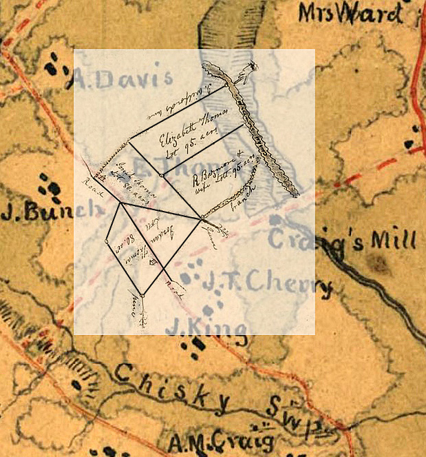
 A few years ago, I wrote a post about these things as related to my own research …telling of curious tracts of land and the numerous locations where I believe my Thomas family possibly lived. Here is a map I altered showing the areas I was studying:
I was hoping that someday, someone would respond and set me straight. That very thing recently happened in part by way of a pingback indicating that Colonial Andersons of N. Carolina had mentioned my post in connection with theirs entitled “the Tuscarora Town.” In that post, the lands of Milton, Busby, Parker and others have been accurately platted near the Roanoke River not far from Woodville. The platted lands on the post were once owned by a person named Joseph Thomas. For the first time, I can look at the area with clear understanding of the early community. It’s also proper here to note that this information jibes with what I had learned from my friend Gregory Tyler whose family home stands nearby.
All of this is wonderful though finding this information in no means eliminates my concerns. Yes, it’s possible I relate to a Joseph Thomas who owned land in the vicinity of Running Creek near Woodville though I find other records of a person named Joseph Thomas who lived 12-15 miles away, closer to present-day county seat of Windsor. Are the two Thomas men named Joseph related, possibly the same person or do their purchases of land reflect different generations of the same family? Note there are also Phillip and Lazarus and other Thomas men who once lived to the north, along the present-day Northampton County line. Some show all these men as being of the same family and yet, others are not in agreement. You would thing Y-DNA would give us the answer though at this point not enough good Thomas men have been tested! Is it possible that any family ties are much more distant if even related at all?
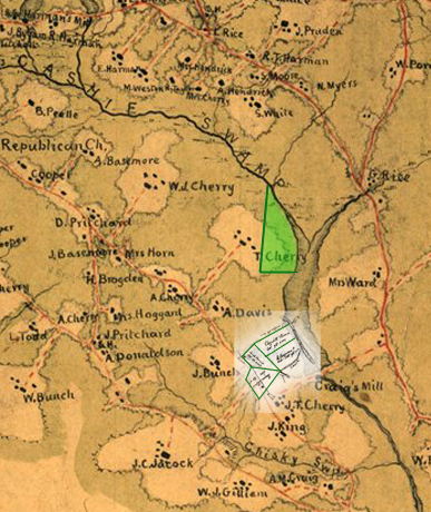 At some point soon I want to revist records for Thomas lands in the vicinty of Woodville. But for now, my curiosity leads me down Hwy 308 to Joseph Thomas who purchased land in 1727 from Samuel Bass. That land is identified as lying south of Kesia Swamp and is the first known deeded land for “Joseph Thomas in Bertie County.” Looking back a few months earlier, Samuel Bass had purchased the same tract from William Griffin. Overlaid atop a historic map drawn during the Civil War, the tract originally attributed to this “Joseph Thomas” appears roughly in green. Oh, and as will be later shown, the tract in white belongs to Josiah Thomas, who we believe is a descendant of Joseph Thomas.
_____________________________________
 A year ago, I graphically overlaid a topographic map with the plat of a 700-acre land grant issued in 1786 to David Standley (seen outlines in red below). The piece of land ran miles down the Cashie Swamp and its original survey shows the names of adjoining owners (right). Of interest in this exercise, the survey also references the mouth of Connaritsa Swamp and historic Lumber Bridge which crosses Cashie Swamp between the communities of Snake Bite and Republican. This was fun to see as I knew the tract could be graphically expanded or made smaller until the illustration correlated with known locations on topography maps. The tract, being long with a bend south made me realize how accurate the surveyors were in the early days. Anyhow, related to this post, note in the image below that the southern-most end of the tract adjoins the lands of “John Hill,” just as David Standley’s survey suggests.

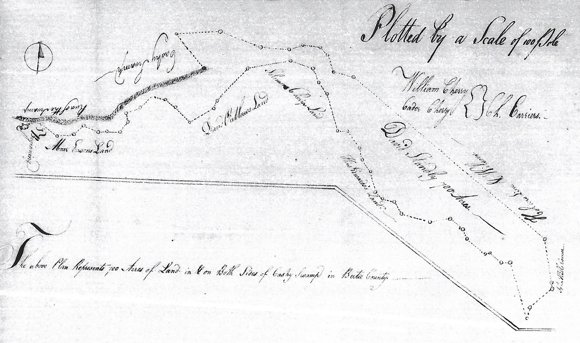
US Topographic Map Collection – [M-204 Bertie, 3 Aug 1773, Whitmell Hill and Winefred his wife to Josiah Williams] Being 700 acres of land lying in Cashy Swamp beginning at a little cypress on Cashy Swamp being in the line of Catherine Hunter minor of Moses Hunter Dec’d then N 44 W 90 along Cashie Swamp being her line to a beach her corner standing on the swamp then up the swamp being Maj. Robert West’ line S 85 W 38 to a gum on the sd swamp then along the said swamp N 57 W 22 to a cypress then along the swamp N 75 W 26 to an ash then N 76 W 12 to an ash in the swamp then S 51 W 28 to a beach on the swamp then S 41 W 28 to a beach then S20 E 32 to a beach then S 18 to a cypress then S 44 W 24 to a beach then N 41 W 8 to a white oak on the swamp then N 15 E 26 to a gum then N 16 W 28 to an ash then N 42 W 38 to a maple then N 19 W 36 to beach N 52 to a beach on the swamp then N 33 W 24 to a gum then N 68 W 26 to a gum then S 78 W 48 to a white oak then North 16 W 30 to a beach then N 3 E 36 to a poplar then N 42 W 2 to an ash then N 12 E 16 to a water oak then N 40 W24 to a gum on the swamp near (Bryar?) House then N 36 along sd swamp being Joseph Thomas’s line to a cypress in the swamp then N 11 W 50 to an Elm then N 71 W 20 to a cypress then N 7 W 26 to a beach then N 43 W 28 to a beach then N 46 W 70 to a cypress then N 10 then N 7 E 36 along Henry Bunch’s line to a white oak then N 8 W 22 to a beach then S 72 W 20 to a cypress then along the swamp being Bunch’s line then N 27 W 34 to a beach on the swamp then N 33 E 16 to a beach then N 57 W 18 to a beach then N 27 W 68 to a beach on swamp then N 22 to a chinkerpin then N 43 W 20 to a beach then N 18 to a beach then N 30 E 26 to a chinkerpin then N 44 W 20 to a hickory on the swamp then across the Cashy Swamp to a pine on the swamp standing above Micajah Thomas’ plantation then down the said swamp S 28 E 14 to a red oak then S 12 W 56 to a beach then S 33 E 16 to beach then S 7 W 27 to a pine then S 53 W 16 to a dogwood then S 11 W 14 to a gum in John Hill Junior’s line then S 51 E 6 to a beach them S 46 to a sourwood then S 36 W 30 to a chinkerpin then S 47 E 38 to a gum them S 8 E 42 to a pine in Whitmell Hill’s line then S 44 E 22 to a hickory then N 53 E 8 to a pine then S 65 E 20 to a pine. Witnesses are Hezekiah Mohum and Bart. Barnes.
Starting with the first survey line at the southern-most end of this tract (shaded green below), the deed reads:
“beginning at a little cypress on Cashy Swamp, being in the line of Catherine Hunter minor of Moses Hunter Dec’d then N 44 W 90 along Cashie Swamp ….”
Note that the mentioned land originates as a grant to Robert West who sold it to Michael Hill (G-289 Bertie). Michael Hill in turn sold it to Robert Hunter (G-282 Bertie) who happened to be Katherine Hunter’s grandfather. In 1753, Robert Hunter penned his last will and testament which reads in part:
“7thly I Give and Bequeath to My Loving Son Moses Hunter … one Tract of Land Lying on Cashy and Willis Quarter Swamps which sd. Land, I bought of Coll. Robt. West & Michael Hill this Land I Give to the sd Moses his heirs and assigns for Ever …”
Providing the perfect starting place for orienting the sprawling lands purchased of Whitmell Hill, note that the Hunter lands (shaded green) are described in- deed as:
“lying in ye fork of Cashy and Wills Quarter [now Hoggard’s Mill] beginning at a beach in Cashy swamp & running a north east course to Coll. Robt’ West’s corner, from thence a southeast course to Wills Quarter Swamp, then down the Swamp to the fork, then up Cashy Swamp to the first station.”
From this information we know that Whitmel Hill’s 700-acre tract ran all the way from Wills Quarter northward past the mouth of Guy Hall Swamp (now White Oak Swamp) to where the tract abuts the lands of David Standley.
Also, now knowing that the Hill and Hunter lands adjoined land owned by Robert West, I have a good understanding of a particular piece of land purchased by Joseph Thomas in 1746. But before going into that, look back at the green lines of the sprawling grant originally issued to John Hill before being passed down to Whitmel. Note how the lines somewhat follow the swamp edges when compared to the underlying topography map. To the west of Robert West’s lands, note how the old survey dips severely at one point while the topographic map takes the Cashie River on a gentler curve. See it? Zooming in on this area using Google Maps, amazingly it is easy to ascertain the ancient swamp edges which did in fact once dip more severely to the south.
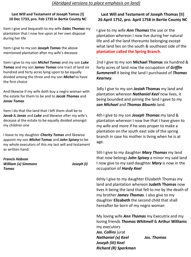
Our family believes there is a Joseph Thomas (I) who dies in the 1730’s followed by a son Joseph Thomas (II) who dies in the 1750’s. With that in mind, Joseph Thomas purchased land in 1746 by John Bell (G-78, Bertie). This deed indicates the land was purchased by Joseph Thomas (II) as his believed father had already passed. Later, in 1769, the very same piece of land was sold again by Joseph Thomas to Joseph Collins who had served as witness in the 1752 last will and testament of Joseph Thomas (II). This last sale was made by a person we refer to as Joseph Thomas (III) who we believe to be the son of Joseph Thomas (II). Joseph Thomas (III) moved west where he eventually wrote his last will and testament in 1819 Chatham County NC. Joseph Thomas (III) had also been indentured to David Turner in 1763 to learn the art of cabinet making. Court recordings of the indenture reads:
Feb 1763, Bertie – Ordered that Joseph Thomas orphan of Joseph Thomas Dec’d be bound to David Turner to learn the trade of a Joiner and Cabinet Maker of ye. Age of sixteen years.
The deed in 1769 indicates Joseph Thomas (III) had reached legal age, having completed his indenture. This would be his last known record in Bertie County before moving to Wake/Chatham.
Take a minute to locate the corner identified with a red letter “A.” See it? Today this corner stands along or near School Road, just east of Thomasville Road …can’t make this stuff up! However, back in 1774, the survey of Hill’s deeded land identifies that the lines passed by “Friers House” before intersecting the “Joseph Thomas” line and his cypress corner at the red letter “A.” This is likely the western terminus of the land Joseph Thomas (II) purchased of John Bell (shaded purple). Also, and having written about this before I ever knew of the above, an 1813 estate land division for the lands of Josiah Thomas was situated across the river from this land. From the division, we know Josiah had children Jordan, Josiah Jr, Elizabeth, and Sarah who married Reuben Bazemore. Finally there was one more conveyance of the land at red letter “A” that had already passed from John Bell to Joseph Thomas (II) and from Joseph Thomas (II) to Joseph Thomas (III) before falling into the hands of Joseph Collins. In 1814, Jacob Collins of the State of Georgia and County of Tatnell of the one part acting agent for Joseph Collins, heirs David Collins, John Collins, and john Collins heirs and Drury Wilson of the state of South Carolina Edgefield district, Jonas Summerlin & wife of Bertie Boswell (Braswell?), Charles Collins and the heirs of Miliba Collins of the one part to John Bass (Y-40 Bertie). Being sale of David Collins estate, the land in question is the same as that which was deeded to Joseph Thomas (II) by John Bell. Oh, and following the death of Joseph Thomas (II), his widow Ann married the above-mentioned David Collins.
Following the green survey to the north, the green lines of Whitmel Hill’s 700 acres passes two tracts owned by Henry Bunch (see the red letter “B” & “C”). Note that the above Joseph Collins married Rachel, the mulatto child of Henry Bunch.
Now, north of the red-letter C, note how the Cashie River bends severely as it passes White Oak Creek, once called Guy Hall Swamp which enters to the north. Being the earliest known land owned by our earliest known Joseph Thomas (I) in the area, in 1727 Joseph Thomas purchased 200 acres from Samuel Bass (C-212 Bertie). On the very same day, Joseph sold to Samuel Bass his lands along Oropeake Creek located near the Virginia State line in present-day Gates County. The metes and bounds for the Cashie River land reads:
“on the south side of Kesiah Swamp beginning at a pine in the woods by William William’s plantation, then north 5 east 320 poles to a pine standing on the Kesia Swamp, then according to the winding of the swamp to the mouth of the great branch, thence the various courses of the said branch to a pine in his headline, then along the headline to the first station. “
Do I have this correct? Going from the Great Branch to Kesia or Cashie, is the terminology used to identify river changes occurring as the waterway transforms from a true river to becoming more or less a swamp? Through my eyes it appears this tract is situated somewhat in the purple shaded tract. However, yet another conveyance of the same land shows the tract may have been but a portion of an even larger tract. In 1774, Whitmel Hill and wife Winifred again sold and to Josiah Williams (M-206 Bertie). Being the next deed in the deed book from Whitmel Hill’s conveyance of the big green sprawling tract, you’d think and would be correct that the two pieces of land are near each other. From this second deed, the metes and bounds read:
“Beginning at an old ash on John Hardy’s corner tree, then south 65 west 270 poles to a pine, north 25 west 320 poles to a pine, north 65 east 320 to a pine on Cashy Swamp, then the windings of the swamp to the first station.”
Not the same metes and bound as appears in the conveyance from Samuel Bass to Joseph Thomas, this deed goes on to reveal additional details:
“Containing by patent granted to John Griffin 591 acres and was given by Wm. Griffin, son of the said John Griffin to his wife Mary Griffin by will which land …except a parcel of the land which was sold by William Griffin to Samuel Bass containing an estimated 320 acres …know by the said sale to the said Bass since belongs to Joseph Thomas.”
Reaching the most-northerly end of Whitmel’s 700-acre conveyance, the lines cross the river for which no distance or directions are given. Differing from what I have drawn, at this point I believe the northern end of the tract should be bent or shifted a bit to the east so that the lines cross the river only once as indicated. Also, at spots the width of the tract is surely narrower or wider as we really don’t know what the line crossing the river looks like. However, if I ever had the chance to walk this area, I think it being the tight bend across from the mouth of Guy Hall Swamp (now White Oak Swamp), I would be able to also see the lands sold in 1727 to Joseph Thomas. And if that’s not telling, now turning to follow the green lines and the run of the river south, Whitmel Hill’s conveyance continues after crossing the water:
“…then across the Cashy Swamp to a pine on the swamp standing above Micajah Thomas’ plantation then down the said swamp.”
I believe this is Michael Thomas, son of Joseph Thomas (II). After Joseph died in the 1750’s, Michael was appointed guardian of his younger brother Josiah. Josiah appears in period tax lists as living in the home of Michael Thomas. Note that in his 1752 last will and testament, Joseph Thomas (II) leaves to wife Anne his plantation “known as Spring Branch.” And in item 2, Michael Thomas is bequeathed 640 acres purchased of Thomas Kearsey.
Note that Thomas Kersey purchased land from William Ricks that adjoined lands of Thomas Busby (B-173 Bertie). Clearly, this purchase happens to be 12-15 miles away, being part of the lands near Woodville identified on the Anderson of N Carolina blog site. This deed is extremely valuable in that it solidly connects the estates of Joseph Thomas (I) and (II). And yet, in item 3, Josiah received land occupied by Nathaniel Keel joining Michael and Thomas Blount’s land. You would immediately assume this land was also situated near Woodville and that may be correct though who was the named Thomas Blount? The father of Winifred who married Whitmell Hill, a Thomas Blount, late of Edenton, purchased 591 acres south of Cashie from John Lett (F-200 Bertie). The description mentions John Hardy’s corner and further states the land was given by
“William Griffin son of sd. John Griffin to his wife Mary by will ..which land was sold by William Griffin unto Samuel Bass …since belonging to Jos. Thomas.”
Some say the Blount family of Woodville area are Tuscarora, are they? Or are they kin to Thomas of Albemarle?
There’s much more we could say about Michael Thomas though back to the green-lined tract sold by Whitmel Hill to Josiah Williams, after leaving the “Micajah Thomas plantation,” the next mention in the survey is of adjoining land owned by John Hill Junior. Oddly, John Hill Junior does not show up on any Hill family trees and is considered an unknown. However, for the Thomas family, we know for sure that he married Anne, the widow of Joseph Thomas (II) following Joseph’s death in the 1750’s.
In 1766, likely at a time of coming of age, Joseph Thomas (II)’s son Josiah Thomas was deeded land by Joh Hill (L-80) “in consideration of the Last Will and Testament of his father Joseph Thomas deceased.”
“Being on the south side of Cashy River, …beginning at the mouth of the Great Branch between the said and Michael Thomas’s Plantation running up the said branch westerly to Joseph Thomas’s line then aling his head line south to a lightwood limb & marked pine tree Whitmel Hill’s corner, then eastwardly along a line of marked trees to the head of a branch called Middle Branch, then down he branch to the Cashy Swamp and then up the swamp to the first station.”
Note that the land is deeded by John Hill, not John Jr and the deed is witnessed by Joseph Collins.
And then in the same general vicinity, Josiah and Nancy Collins sold to John Thomas 70 acres (P-180) lying on the south side of the Cashie Swamp beginning at a stooping oak in the Spring Branch then down the various courses of the said branch to a pine in the branch then running across a line of marked to another branch that makes out of the Spring Branch to a water oak then running the various courses of the said branch to the head line Jesse Bazemore’s line then running across a line of marked trees to the first station, being the land that Michael Thomas sold to John Capehart and the said Capehart sold to John Freeman and & by Freeman to Josiah Collins. The deed was witnessed by Josiah Thomas, John Collins, and Mary Asbell …all identified in the 1752 last will and testament of Joseph Thomas (II). I have no idea who John Thomas was, though Josiah witnessed the deed.
Returning to the green-lined survey of Whitmel Hill’s conveyance, next down-stream below John Hill Jr is mention of none other than Whitmel Hill. There ae numerous deeds connecting to families of Pugh, Hill, Freeman, Hardy, and Bazemore. However, to be able to properly place and draw the tracts, I must first know for sure the locations of several ancient streams once running through the area. One such tract passed from John Capehart to John Freeman (O-52), then from John and Sarah Freeman to Francis Pugh Junior. Note that this land adjoins Thomas Clark, John Bazemore, Jesse Bazemore and David Collins, who married Anney, the widow of Michael Thomas who died in 1766. There is so much more to be gleaned but my out-of-towner knowledge does not know locations that surely exist on old deeds and plats quietly held by area farmers. To be able to draw adjoining lands, I need to know the locations of Spring Branch, Middle Branch, and Thick Branch.
 Now, at this point the green lines of Whitmel Hill’s survey ends abruptly as I believe an ancient page of a recorded deed has been lost. From that point south, the tract surely passed by lands that were later owned and passed down by Josiah Thomas via his 1813 estate. As appears in a more detailed discussion, this land is located near the old Craig Mill. Opposite the river from the Joseph Thomas (II) purchase of John Bell, this land appears to be somehow connected. And looking at the above map of Whitmel Hill’s conveyance, I’m sure that if it the deed had survived intact, further mentions of Joseph, Michael, and Josiah Thomas would appear in the description now lost and gone. However, going one step further, let’s look at the period 1770 map by John Collet. As has been pointed out, some things are not to scale and are even misplaced. Though, the map clearly shows Hill’s Mill on a stream shown in the above topography map as following the western side of Whitmel Hill’s conveyance. I’d love to learn more about this area and of the creeks and odd waterways needed to carry this conversation further ….

Well… at least we have started a conversation… (smiling)
thanks for stopping by my blog…
Marc aka andersonnc.com
By George, Cousin George, I think you could do time travel if you wanted. I combed through your piece looking for a got-cha and couldn’t find one so let me make an assumption. Joseph II knew he might die before his kids were adults. We are fortunate that he left a will and kept things in the family and out of court. I wonder if he had a position in law enforcement or some other kind of risk? If so, Joseph Thomas (II) could show up as an official of some kind in County records to verify more assumptions.
Dan, those sorts of finds are few and far between and have seen nothing to give us a clue His son Joseph (III) was indentured to be a cabinet maker. So maybe a builder and surely a farmer.
My Thomas lineage and I have no idea if they are the same line as you. Met you at the Bertie Genealogy meeting yesterday. https://www.ancestry.com/family-tree/tree/80726995/person/230034941511/family/pedigree/print?_phsrc=WLs19&usePUBJs=true
If this link does not work- here is the short version: Anne Askew (1740-1825) of Bertie my 6th great grandmother from Aaron Askew from Nicholas Askew who married Sarah Oglethrope daughter of Thomas Oglethorpe who married Katherine Thomas (1639-1687) and would be my 9th great grandmother. All of the above lived in Isle of Wight, VA except Anne and Aaron Askew lived in Bertie. John Davis Thomas from Wales immigrated to VA colony and Katherine was his daughter. Isle of Wight is a typical migration point to Chowan/Bertie
Hi Cynthia …and also enjoyed meeting and talking with you and others at the event. I honestly don’t adhere to genealogies going back beyond NC as there are simply too many missing records allowing for opportunities to get it wrong. I think such trees should include a greater use of the word maybe. Anyhow, There are two, at least, Thomas families in early Bertie. I met a fellow at the event who was Josiah who is surely from the lineage my family believes “may be” ours. Even in that belief there are no records at this time making our connection from Bertie to Wake. I think the family up near Askewville is the other family though Joseph in our lineage seems to have acquired land near Hope and then west of Woodville. That could be a matter of confusion between father and son of same name influencing how we interpret a 1735 will and one written in 1752. For now, I am heading to Charlotte with my mom today and will be out of pocket through early next week as we prepare for her birthday and niece’s baby shower in the mountains. Will look at what I have on your tree but may not be able to dig deeply till middle of next week.
I think there were multiple David Collins. The one who married Annie might have been the son of John Collins who left a will in 1751, in which he named David Collins as a son and left him a Bible. But the David in that 1814 reference could be a son of Joseph Collins, who left a will in 1802. Today I discovered in the court minutes a record of a suit involving a James Collins from 1770 as well as a Walter Blake. Walter was a brother of James Blake, and these names Thomas Clark, John Capehart, and Freeman pop up as neighbors. So I am trying to determine how this older James Collins fits into the picture. Maybe he was another son of Joseph Collins and Rachel Bunch?
Hi, what a great read. My Holland Family is from this area. If we have the facts correct it would be William Holland about 1697 from Virginia. Records are not complete due to wars, floods etc. As we have been researching for over 25 years information has become easier to find. If you have any information on the Hollands in the area between 1710- 1770 and would not mind sharing it would be appreciated.
Hi Sally, I was able to trace a group through Bertie into Edgecombe and further west from there. Earlier yet, there are a large number of Holland n what seems to be the same family spreading out of Virginia into Chowan and Bertie. I used the family’s later spread through Edgecombe to help identify others in my family who moved with them into now Wake NC. I do not have the depth of understanding to distinguish among all I saw, but can advise to use new Experimental search tool linked to the bottom of the opening page of familysearch. You can type in say Holland for Chowan and find all land etc mentions of the name within records of that county ….limited and not containing all the court records …yet.
The Micajah Thomas family line has quite a line. Massive land owners. Lands handed down, or donated to many. Also had many slaves, many his family set free. Micajah’s father is Micajah. His daughter was Margaret Ann who married John Alston who later sued Hezekiah Thomas in Barnwell SC in 1825.. (Real soap opera) Micajah Thomas first wife died. but did have a child. He then “companioned” with an Ann Jackson and had 3 daughters. He names all of the parties in his Will and leaves them all an enormous estate.
Hi Roberta,
I’ve looked at the John Alson-related papers in Barnwell, and see Hezekiah, though not sure of any document proving the lineage is as believed. There were lots of Micajah and does this refer back to Micajah of Nash/Wilson County NC whose home tract later became the county seat? I hope you have looked into this, as it would be nice to discuss further. I’m concerned that much of the family history has been conflated, although I still don’t know how it should be interpreted. Thanks for posting!
Yes, spent last 2 weeks researching the Micajah Thomas line…. It is actually pretty well documented! Got lots of records and info. Even newspaper articles. Also got lots and lots of documents on the Myrick, Alston, Stinson vs Brooker, Thomas line. Got a family Bible for Hezekiah Thomas but it drops off with Hezekiah. (My dad had the family Bible for Hezekiah Thomas but termites got into the trunk and it had to be burned. Mama screamed Noo but too late. Anyway, YES, the Micajah Thomas home seat is connected because Margaret THOMAS Alston is dau of Micajah THOMAS. …and she and hubby donated lands to City so newpaper says. There is Nashville Newspaper with a writeup as to the lineage connection. I cant quite figure out how and why she is listed with my Hezekiah Thomas branch and this law suit in Barnwell. Was Margaret a sister, niece or cousin?? Was Hezekiah an orphan of James Thomas??? and possibly raised by Micajah? PS– have you checked the GRC of the DAR? There are many, many documents on Micajah. Also, James Thomas is listed as DAR Patriot, so will be documents on his lineage as well. I am going to research those next. With “image review”. Thanks. Tangled up mess, but slowly, we might get there. Send me a direct email please.
There is a 1755 Nash Co WILL for Micajah Thomas (easy to find) which names Margaret Ann Thomas Jackson (Alston) as his daughter. Somehow, she must be related to Hezekiah Thomas…. and unsure if Hezekiah related to James Thomas, BUT his children have names of James, Joseph, Sarah, Lewis, Mary, (and remaining issue named after wife Mary Brookers lineage.) Appears established format for “naming conventions” was used, typical of period. But no docs to prove.
This might be a “Rabbit hole” we might not need, but somehow, the Micajah Thomas line connected to my Hezekiah Thomas line of Bertie NC— which I suspect (???) is somehow connected to the James Thomas line. Hezekiah born 1780. Was he orphan? raised by Micajah? I note that Hezekia is on 1810 C of Nash Co living next to Micajah, Hezekiah had just married x young Mary Brooker and PG in SC a couple yrs earlier. Did he go back to Nash Co to live with PG young wife next to Micajah?—— just speculation. —- I hope this hyperlink works. Long article..
Micajah Thomas Legacy – Early Nash County – Nash County, NCGenWeb
I will surely email you, but I would like to leave this thread with a few observations from several years of delving deep into legal records, not specifically regarding your Micajah.