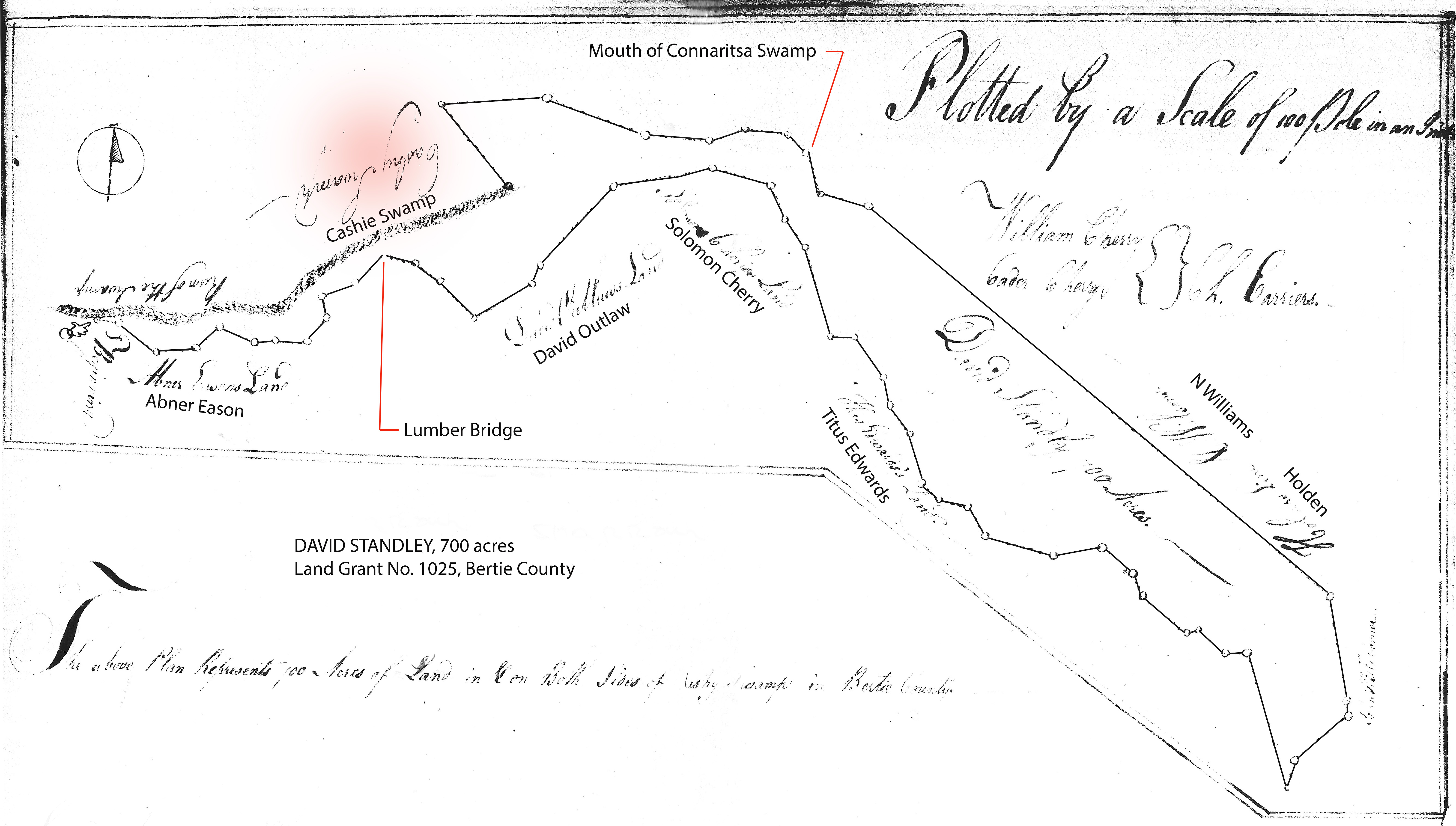
Know ye that we have granted unto DAVID STANDLEY – Seven Hundred acres of land in Bertie County beginning at a gum standing on the edge of the run at the upper side of a fence on a plantation on the south side of the Swamp then south 85 east 30 poles, then south 45 42 poles, then north 85 east 36 poles, then north fifty east 36 poles, then south 65 east 32 poles, then north 30 east 20 poles, then south 85 east 38 poles to a cypress a line tree between SPIVEY and JAS REED, then north 40 east 36 poles, then down the several courses of the swamp, then north 10 west 30 poles, north 70 east 30 poles to the line between STANDLEY and REED, then along STANDLEY’S own line north 45 east 36 poles TO THE FOOT OF LUMBER BRIDGE, then south 70 east 37 poles, then south 55 east 36 poles, then south 45 east 45 poles, then north 60 east 60 poles, north 24 east 20 poles, then north 44 east 94 poles, then north 80 east 95 poles to SOLOMON CHERRY’S line, then south 70 east 50 poles along the swamp side being his line, then south 35 east 30 poles, then South 30, then south 16 east 80 poles, then east 30 poles, then south 36 east 44 poles, to the mouth of southern line, then south 10 east 24 poles, then south 35 east 30 poles, then south 15 east 42 poles, poles, then south 50 east 16 poles, then south 70 east 28 poles, then south 31 east 28 poles, then south 63 east 62 poles, then north 80 east 44 poles, then south 51 east 35 poles, then south 20 east 22 poles, then south 53 east 48 poles then north 80 east 10 poles, then south 50 east 20 poles, then then east 16 poles, then south 25 east 104 poles, south 15 west 26 poles to a white oak acorn tree between TITUS EDWARDS & AARON CHERRY standing on the south side of AARON CHERRY’S branch, then north 39 east across CASHIE SWAMP 82 poles to a cypress tree, then north 20 west 10 poles to a cypress JOHN HILLS corner in the edge of the swamp, then along his line north 10 west 100 poles to again THOMAS HOLDER’S corner, then along his line LAURENCE’S & WILLIAMS north 50 west 538 poles to a branch, POTEAT corner & BUNCH’S, and then along BUNCH’S line south 80 west 48 poles, then north 16 west 40 poles to a maple mouth of CONNARITSA CREEK, then along HENDRY’S line north 47 west 20 poles, then north 83 west 38 poles , then south 70 west 32 poles, then north 85 west 60 poles, then north , hen south 87 west 96 poles70 west 92 poles to a poplar STANDLEY’S own corner &. JAS. THOMAS, then THOMAS’ patent course south 40 east 94 poles to a cypress his corner standing on the edge of the run, then up the windings of the run to the first station. – 23 Sep 1786. Chainers: WILLIAM CHERRY, CADER CHERRY.
The Lumber Bridge has been a noted landmark in Bertie County history since the mid 1700’s. Being the primary crossing of the Cashie Swamp, the bridge connected the southern side of the swamp (a place called Republican) to the town of Snakebite located to the north.
The bridge and communities are located on a wonderfully illustrated map created by the Confederate forces during the war. And to my amazement, the present-day Republican Road follows the same path today as was taken in 1863 when the map was created. Facts like that are vitally important when comparing ancient records to what we see today. And in addition, the old Confederate map locates all the landowners and where they lived. More on that map later.
The 1778 Entry Warrant by Bertie County Entry Officer David Turner mentions that the 700 acre tract adjoined the lands of Tytus Edwards, Solomon Cherry, David Outlaw, Abner Eason, James Thomas, Edmond Standley, Embro Bunch, Hales, and Elisha Holder. The above survey plat and metes and bounds represents a land grant of 700 acres issued after the Revolutionary War in 1785. The huge, sprawling tract follows the run of Cashie Swamp for miles from east of Lumber Bridge well past the mouth of Connaritsa Swamp. The survey plat also labels adjoining landowners which differs from what was written in the warrant and metes and bounds. A clue in itself, the differences likely result from lands being exchanged during process.
Below is an overlay of David Standley’s grant onto an enhanced detail of the 1863 Confederate map of Bertie County. Note that it appears the long left appendage of the grant may have been originally drawn to the wrong angle. That, or the 1863 map was drawn wrong. In fitting the David’s land on the map, as it was originally platted, the left side did not accurately follow the Cashie Swamp. The image below is a quickly drawn interpretation by me correcting the angle of the left side to better follow the flow of the swamp.
James Thomas is identified in the metes and bounds as owning the land on the north side of Cashie Swamp between David Standley and the road leading to the Lumber Bridge. Looking at both images above, James Thomas’s land is located in the red shaded area. From memory, later deeds show the tract going to James Thomas’ sons including Ezekiel at which time transactions mention a mill and the road leading to Lumber Bridge. [Note: with NC Archives closed due to the corona virus, I cannot provide detailed support information at this time.]
The above-mentioned James Thomas is certainly the same person who wrote a will and testament in 1780 before passing. Tradition and early genealogies wrongly established James as being the son of Joseph Thomas who named a son James in his 1733 will and testament. That simply cannot be correct as James’ supposed brother, Joseph II, wrote a will and testament in 1752 mentioning his deceased brother James:
6thly I give and demise to my daughter Elizabeth Thomas my land and plantation whereon Judeth Thomas now lives it being the land that fell to me by the death of my brother James Thomas.
If Joseph Thomas II wrote a will in 1752 naming his deceased brother, how could that brother live to write his own will in 1780? Yet to resolve that conundrum, new research has only served to intensify the mystery. Let us take a look.
___________________________________
In 1766, by the will of his father Joseph Thomas dec’d, Josiah Thomas, a taylor, purchased land from John Hill. Being “320 acres on the south side of Cashy River” joining the Great Branch, Michael Thomas, Joseph Thomas, Whitmell Hill, Middle Branch, and Cashy Swamp. [I-80 Bertie]. And note that following the death of Joseph Thomas Sr, his widow Ann Thomas married the aforementioned John Hill. And note from Joseph Thomas Sr’s will that each of his sons was bequeathed land with this surely being a part.
Josiah Thomas’ brother Michael died young, writing his will in 1766 which reads in part: “I first constitute make and ordain my true and faithful friends Thomas Pugh and Hardy Hayse and Anney Thomas my Executors of this my last will and testament I now give and bequeath to my son Joseph a certain tract of land lying on Cashy Swamp the west side and the north side of Spring Branch at my father’s sd decd.” Mentions of “Spring Branch” in numerous transactions can be used to connect the family members. I will not yet delve into those deeds as I’ve yet to solidly prove the location of Spring Branch. However, once positively found, the Branch will key in unraveling many family mysteries.
Josiah Thomas married first Sarah Bazemore, the daughter of John Bazemore. In his 1780 will and testament, John mentions the family thusly:
“I lend upon my son-in-law Josiah Thomas, husband of my daughter Sarah Thomas deceased, one negro wench named Nancy that is now living with him for the term of his natural life & after his death to be divided she & her increase among my five grandchildren to be Michael Thomas, Jordan Thomas, Josiah Thomas, Elizabeth Thomas, & Sarah Thomas.”
The will was witnessed by Josiah Collins whose grandmother, Rachel Bunch, was identified as being Mulatto, as was Josiah. And, the will and testament of Josiah Thomas’ father Joseph was witnessed by Josiah Collin’s father Joseph, husband of Rachel of Rachel Bunch. Later deeds show Josiah Collins selling his lands back into the Bazemore and Thomas families.
Following the death of his first wife, it appears that Josiah married second a person named Susannah as she is later identified as “widow” in the estate of Josiah Thomas, deceased.
Looking back into the two families, in 1766, Jesse Bazemore purchased 253 acres from Robert Hardy. Being 253 acres, the land was located on the north side of Chesky Swamp, joining Thick Branch, Frances Hobson, Thomas Jones, Joseph Thomas, and Edward Gilman (I-50 Bertie).
Twenty three years later, Jesse Bazemore purchased from Josiah Thomas a tract along John Brown’s line on little Chesky Creek running then up the branch and along the line of marked trees to the road that leads from Cashy Bridge to Halifax then up the road to the Spring Branch (P-85 Bertie). I wasn’t going to mention Spring Branch, but oh well….we now know Spring Branch was near Chesky Creek and the road leading from the Cashy Bridge to Halifax.
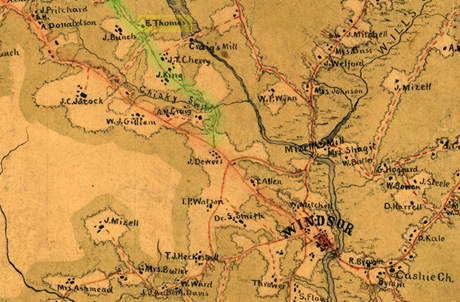
In the map below, you can see Chisky Swamp branching westward off the Cashy River north of Windsor. Both forks of the road passing around “Chisky Swp” on the map will get the traveler to Halifax. The more southerly route (shaded red) is a direct line to Woodville before crossing into Halifax County. The northerly line (shaded green), known today as Republican Road, crosses over the “Lumber Bridge” and James Thomas’ land before passing through Snakebite, then turning west to Woodville. With that in mind, reel forward another 20+ years to the death of Josiah Thomas Senior, son of Joseph II who died ca. 1758.
In 1813, for the widow Susannah Thomas, a committee laid off her 1/3 dower lands which joined a branch and the lands of James Wilford to the north. In 1814 the following plat and division among heirs was laid off by Moses Gilliam, Turner Bazemore, Zed. Stone, and Geo Outlaw, and Simon A. Bryan:

First: Jordan Thomas (80 acres) Beginning at a pine in the road in Turner Bazemore’s line, then to a pine, then along the line of said Bazemore to a pine in Simon A. Bryan’s, then along his line and Joseph S. Pugh’s to a gum in a branch, then south 89 west a new line.
Second: Josiah Thomas [Junior] (80 acres) Beginning in Joseph S. Pugh’s corner gum, Jordan Thomas corner, south 89 west to a pine on the road, along the road to a branch near Josiah Thomas’ house, then along Turner Bazemore’s line down said branch to a chinquipine, then a line of trees S. 84 to the beginning.
Third: Elizabeth Thomas (95 acres) Beginning at old stump, low ground of Cashy Swamp, James Wilford’s corner, then along his line and Turner Bazemore’s to a chinquipine Josiah Thomas’s, then along his line south 48 east to a stake in a field, then north 60 east to a line of marked trees to the Cashy swamp, then up the swamp to beginning.
Fourth: Reuben Bazemore and wife Sarah (95 acres): Beginning at a gum in a branch, Jordan and Josiah Thomas’ in Joseph S. Pugh’s line, then down the said branch, being Pugh’s line, to Cashy Swamp, up the swamp to Elizabeth Thomas’ corner, then along her line to a stake in the field, Josiah Thomas line, then along his line to the beginning.
It appears that Josiah Thomas’ son Michael died young as he is not mentioned in the estate division. However, it remains possible he moved west.
Fast forward again 47 years and in 1860, the above Josiah Thomas Junior is listed in census as 85 years old, living in the home of his son Everitt Thomas. With that in mind, look closely again at the map above. Along the green shaded Republican Road, the 1863 map identifies “E. Thomas.” Because Josiah, born 1773, was living in 1860 at the home of his son Everitt, I assume the above mapped location is the same as the 1813 plat where Josiah Thomas Junior received an 80 acre share of his father’s estate. And on that piece of land, the division mentions and draws in the location of “Josiah Thomas’s house.” I assume that in 1860, Everitt and his father lived in the same house that Josiah Senior lived in when he died in 1813. Looking at the 1863 Confederate map, and overlaying it with the 1813 division plat, I was amazed at how accurately the run of the road, the house, and swamp fell into place. If you want to carry this further, look at Google maps. The intersection of the road and corners of Jordan and Josiah Thomas lands in 1863 is the same as the present-day crossroads of Republican and School Roads. Nearby is a little road called “Thomasville.”

From the map we learn of Craig’s Mill. At some point I’d like to trace that land back in time as it should have once belonged to James S. Turner. But of the mill, from an old USGenweb site on Bertie County Mills, the following is said of Craig’s mill:
Owned by Rev. A.J.M. Craig, who married a Gilliam and who was the father of Governor Locke Craig. This dam was the means of escape for the 62nd Georgia Cavalry after the Battle of Windsor when the 125-man unit was attacked by 1200 Union soldiers from Plymouth.
Looking at neighbors, and the surrounding lay of the land, one can begin to put together the past. In 1863, to the southwest of Everitt Thomas’ house is W. J Gilliam. He was certainly a descendant of William who helped divide the Josiah Thomas estate in 1813. The Bazemore family lands come into play to the north and going further north as you near Lumber Bridge is the Cherry and Bunch lands. And pulling the loose estate papers for neighbors throughout the period, of special interest, depositions from the 1830’s estate of Joseph S. Pugh adds flavor while raising new questions.
Joseph S. Pugh and Jeremiah Bunch jointly operated a sawmill with John Butler employed as miller. Testifying in the hearing, Butler told of the mill house and of another workshop used by Jeremiah Bunch. He told of “Sawing Season” likely a time of year when the waters ran at the right level to run the mill. At question was the annual hire of a slave who helped with the milling. Joseph Thomas related the hiring of “a negro named Joe, belonging to David Stone’s estate, to his (Thomas) getting of logs for the saw mill and the piling of plank. In figuring out costs, lumbered wood was sold at a price of $1.00 per hundred feet of planking with $1.50 per hundred being the price for scantling, which is a smaller, more accurately dimensioned wood. Apparently two sets of books were kept with one reserved for “memorandums.” The practice led to Jeremiah not getting paid and hence the issue was raised during the estate settlement.
Levin Butler testified that he lived at the mill for two years and that earlier he did so at the mills of Outlaw and Butler. Levin said that 75,000 feet of wood being sawed was a fair average. At issue was a house built for James Cherry, being “28 feet long, 16 feet wide, 10 foot pitch, the roof 11 foot pitch, a piazza 28 feet long, 9 feet wide, with a room at one end of it 12 feet long.”
George Thomas deposed that Jos. Pugh was to provide the materials and Bunch the millwork. “He was to furnish the logs and float them down to the mill. But does not know the arrangement between them, as to the logs got out of the Highwoods.” “Samuel Pierson?, ——-“ Among them Thomas Speller and Josiah Thomas had logs sawn up, but on what terms the sawing was done for Mr. Speller, he does not know. The sawing for Thomas was on shares.”
From the estate sale, Joseph Thomas and James Collins bought two canoes.
Joseph Scott Pugh was from a wealthy family. His father Francis Pugh married Elizabeth Standley, daughter of David Standley. Though Joseph S. Pugh owned land in numerous places, I wondered about his land adjoining the estate of Josiah Thomas Senior. Overlaying the estate plat to the 1863 Confederate map, and seeing that the Craig Mill at that time adjoined the Thomas land to the south, and realizing this was the land Joseph S. Pugh, is it possible that Craig Mill once belonged to the said Pugh?
The thought becomes especially tantalizing seeing the words of Josiah, George, and Joseph Thomas recorded in the 1830’s estate deposition for the deceased Joseph S. Pugh. I can imagine the mill in place and logs being floated downstream by a slave of the deceased Governor David Stone. II can imagine Joseph Thomas with his newly purchased canoe proudly gliding along the Cashy. Everything fits though, because NC State archives is closed due to the pandemic, I am prevented from doing a title search of the land. I cannot prove this until we get back to normal.
And of the depositions, who are George and Joseph Thomas? Josiah did not have sons of those names. Grandsons maybe? How do they fit into the family?
At this point I have not been able to identify the parents of George and Joseph. It’s possible they were sons of the deceased son Michael Thomas who appears to have died young? George and Joseph could also have been born to Jordan Thomas. He married Milly LAsiter in 1795 with next door neighbor James Wilford serving as bondsman. Jordan Thomas disappears following his father’s estate division. Regardless, the above George and Joseph are seen numerous times in estate and other records connected to the neighborhood of Josiah Thomas, senior.
At this point I will stop with this post though know that the mystery continues. There exists Josiah and Jordan Thomas to the west in Franklin County NC. It appears they are not related, though the discovery of several records raises hesitation. All of that will be dealt with in the next post. As for now, it’s good to know where Josiah Thomas senior lived as well as James. The two can’t be brothers though may be kin. I’ll leave it like that.

Wow, you did a good job matching those old land diagrams to the 1863 map. I have Outlaw ancestors from the same area, would love to figure out exactly the same info for them, but my geographical sense isn’t that great and I can hardly read the old wills.
Jeffrey, I have seen Outlaw family connected and in record nearby. But from deeds, estate divisions etc, you have to find a map or something that connects in names etc to others and to a location, such as a creek. It’s hard work but can be done. Problem now are all the record repositories are closed, making it impossible to do the title searches. Who did your IF you could figure out who your Outlaw family sold their land to through 1863, the Confederate map at that time will tell you where that family lived.
Jeffrey, actually, a petition before division states that surrounding land on one side was owned by George Outlaw.
I find your emails fascinating, thanks for all your hard work.
You are amazing! Great write up and I know that you did alot of deep digging to get that information. Sometime when you geto bored (sure) I sure could use some help finding John Thomas 1770 – ? born in Charles Co Maryland, lived in Granville Co N C 1793 – 18? who married to Susanna Duty in 1798 Granville Co N C last heard from when he sued Benjamin Duty in 1810 in Person Co N C….. he would have my brother’s DNA… brother to my Robert Thomas 1770 1806 & George Thomas 1780 – 1850 Scott Co Virginia….. Great Work!
I love all of your hard work! Recently I have noticed a few items on my property that may be of interest to you. I noted an Indian trail marker tree and there is a shelf of oyster shells in the bank of our creek. I don’t know but I think that possibly they may be significant to someone who knows more about the history of Indian settlements in the area.
Does anyone have any information regarding Moses Purvis b 1745 d 1812 Bertie Co.
sorry, but no I don’t …will keep my eyes open
“From the estate sale, Joseph Thomas and James Collins bought two canoes.” Can you point me in the direction of this record? This James may be a relative. Thanks.
It’s on familysearch, the loose estate papers for Joseph S. Pugh, deceased. Lots of good info in that file folder: https://www.familysearch.org/ark:/61903/3:1:33S7-9PT3-FBC?i=17&cc=1911121
It’s very interesting, because I don’t know who this James Collins is. I am assuming he is the one born in about 1810, in the 1830 census, who was living in Indian Woods, and who died in 1869. But I have no idea where he came from. There is a blackout period from 1800 to 1830 when there are no Collinses in the census in Bertie County.
Actually, he could also be James, a brother of my ancestor Thomas, of Nansemond County (and previously Gates County). He was out of Nansemond in the mid-1820s and then returned. Maybe he was in Bertie.
Very interesting. I am kin to the Thomas’ that live still own the land marked on the map as E. Thomas. The J. Bunch is definately Rev. Jerimiah Bunch . I live across Cashie swamp from the E. Thomas. Where the Mrs. Ward lives is on HWY 13 and the County has a comminucations tower where that house was. There is something interesting in the swamp between where I live and the E. Thomas land. There across the swamp appears old cement bridge supports. One of each side of the main run of the swamp, maybe 20′ apart. There does not appear any type of damn so I doubt this was a mill. The damn around Craig’s mill is very visible. There also looks like to me there could have been a mill on the back side of where A.M. Craig’s house is shown. at the very bottom of the map where the road crossed over Chisky swamp. I would like to discuss further via email