
Above is a portion of the old Marcom Map which shows land grants in early Wake County. Wake County is represented by all of the area with white background while the green shaded land is old Cumberland County, now Harnett County. To the west you see the yellow shaded area which is old Orange County, now Chatham County. And about Wake County, note that a southern sliver of that county was originally formed from Cumberland while the western lands of Wake were cut from Orange.
I remember years ago seeing this and noticing names connected to what I had thought was my family’s home lands along the Rocky River which runs through Southern NC. In the map I see lands of Silas Green who connects with William, Richard, and Leonard Green who we know made the move south. My Thomas family in Anson County connects to Gideon Green who somehow connects to the Green family/families of Wake. My earliest known ancestor, Benjamin Thomas, may be the son of or somehow related to a person named Jacob Thomas who quietly appears in the above land study.
I also see Nathan Thomas and Dilliard or Hilliard Thomas who lived not far from Joseph Thomas in early Wake County. Joseph Thomas, ancestor of many in present-day Chatham-Moore-Harnett Counties lived near present day Shearon Harris Lake, not seen on this map but is just a bit off of the map to the west. Recently my DNA has proven to match descendants of Joseph Thomas and in that I remain curious as to possible connections to the other Thomas families (Nathan and Hillard) who we have yet to find descendants to test. And, look closely and you will see the name Joseph Thomas mixed upon some of the records outlined below. This never escapes my mind and someday I will be able to understand the relationships binding us just as do the property lines as seen on the map.
But for now, I want to try to look at all this in a slightly different way. Recently, David McCorkle digitized all the early Wake County land grant surveys on his site called NORTH CAROLINA LAND GRANT IMAGES AND DATA. For this post, I decided to screen print individual survey images which have been resized and floated into place based on the above Marcom Map. I refer to all of this as an alphabet study to maintain focus while protecting my personal sanity. Note that I’m limiting the number of plats to the number of letters in the alphabet. Oh well, it works in concept though you will notice I did go over by one. Anyhow, take a look at my map below utilizing hand drawn boundaries from 240 years ago. It blows my mind how well the accuracy various surveyors were able to maintain any sense of accuracy! Even though some of the names are not found in court and deed books, it is nice to be able to realize the possibilities revealed in studying the neighborhood where family once lived.
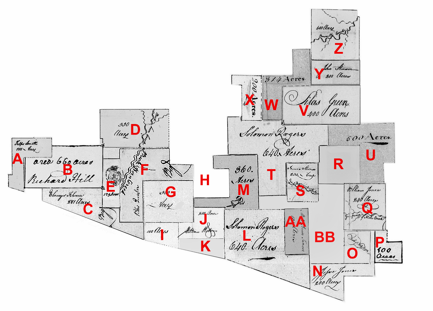
A. Felps Smith, Wake County Grant # 484[A] – 300 acres issued 1780. Both sides of Buckhorn joining Richard Hill and the county line. CC: David Jones, Elkin Jones.
B. Richard Hill, Cumberland County Grant # 48 – 660 acres issued in 1763. Both sides of Buckhorn.
C. Ebenezer Folsom, Wake County Grant # 995 – 281 acres issued 1787. South of Buckhorn, joining “formerly Charles Jones”, Watson’s, Felps Smith, and the County line. CC: Joel Edwards, Frederick Jones.
D. Francis Hobson, Wake County Grant # 453 – 350 acres issued 1780. Both sides of Buckhorn, joining Britain Womack, William Jones at a rocky hill, and Wm. Watson. CC: Carnaby Stevens, Elkin Jones.
E. Dennis Collings [Collins], Cumberland County Grant # 47 – 175 acres issued 1763. Both sides of Buckhorn joining John Smith. This land was later sold to Charles Smith. Likely surveyed at the same time as Grant # 48 to Richard Hill.
F. Peter Quarles, Wake County Grant # 1054 – 400 acres issued 1787. Both sides of Buckhorn, joining William Jones, Charles Jones, and near David Jones. CC: Joseph Thomas, James Stephens. Question: Is this Joseph Thomas III or his son who married in 1789 Mary Oaks?
G. David Jones, Wake County Grant #495, 300 acres issued 1780. South side of Buckhorn joining Felps Smith. CC: Felps Smith, Elkin Jones.
H. Albritton Jones? The Marcom map indicates the land in area of “H” belonged to Albritton Jones though I’ve yet to find the legal deed or grant for that piece of land.
I. Felps Smith, Wake County Grant # 457[A] – being 100 acres issued 1780. Waters of Buckhorn, the warrant says on both sides of Horse Branch and the Survey says both sides of Horse Branch. CC: David Jones, Phelps Smith.
J. William Watson, Wake County Grant # 974 – being 200 acres issued 1787. Horse Branch, joining Phelps Smith, David Jones, and the county line. CC: John Burt, David Smith.
K. David Jones, Wake County Grant # 0121 – being 50 acres with the “0” in the file number indicating the grant was never issued. The original warrant was for land adjoining his own and the Cumberland County line.
L. Solomon Rogers, Wake County Grant #1470 – being 640 acres issued 1809. Warrant to Survey mentions joining to Nathan Thomas. Survey identifies the land on Hector’s Creek joining Mathew R. Turner, the county line, and David Jones. CC: Darling Jones, James Jones.
M. Solomon Rogers, Wake County Grant #1469 – being 360 acres issued 1809. Waters of Buckhorn, joining David Jones, his own, and William Jones. CC: Reddick Jones, William Nash.
N. Jesse Jones, Wake County Grant #1009 – being 200 acres issued 1787. Both sides of Horse Pen Prong of Neils Creek joining his own line. CC: Mark Myatt, James Lightfoot.
O. William Jones, Wake County Grant #975 – being 200 acres assigned to William Jones by Daniel Oldhands and issued 1787. On the Fork of Neals Creek “including improvements made by Jacob Thomas.” CC: Fredrick Jones, Joshua Elkins.
P. William Love, Wake County Grant #1296 – being 100 acres assigned to William Love by Jesse Jones and issued 1798. West side of Neals Creek joining Jesse Jones and William Jones. CC: John Terrialle, Clem’n Stinson.
Q. William Jones, Wake County Grant #975 – being 240 acres assigned to William Jones by Daniel Oldham and issued 1787. Gum Spring Prong of Neils Creek and joining his own line. CC: Joshua Elkins, Fredrick Jones.
R. Hilliard [Hillery] Thomas – No grant, deed, or court record survives for Hilliard Thomas though his ownership of this tract is indicated in “U” above in which he is mentioned in the survey for Silas Green’s land grant. Also,
S. James Stephens, Wake County Grant #1393 – being 200 acres issued 1802. Both sides of the Gaulberry Fork of Neils Creek. CC: Darling Jones, Redick Stinson. Later a James Stephens witnesses deeds between the children of Joseph Thomas in Chatham Caunty.
T. Solomon Rogers, Wake County Grant #1398 – being 640 acres issued 1802. On the Cape Fear, the warrant mentions Nathan Thomas, William Jones, and himself. CC: Reddick Jones, William Nash.
U. Silas Green, Wake County Grant #1230 – being 500 acres issued 1797. Waters of Neals Creek and Braswell Creek, adjoining James Stinson, his own, Croswell’s old field (may be the family of Richmond Croswell who owned two tracts of land in Anson County NC. The first was beside Jacob Thomas and the second several miles away beside Benjamin Thomas Sr on the north side of Richardson Creek). Note that Croswell’s fold field is described in the grant as lying on Hilliard Thomas’ line (southern-most line issued to William Jones in 1787). It also adjoined James Stinson’s corner and the head of Horse Pen Branch. CC: Thomas Beany, Jas. Stinson.
V. Silas Green, Wake County Grant #1035 – being 400 acres assigned to Silas Green by Rowland Stinson issued 1787. Head Branches of the South Prong of Middle Creek, and on both sides of Braswell’s old Road, including the Burnt Tavern, beginning at a hickory near said tavern. CC: Etheldred Jones, James Shelton.
W. Nathan Thomas, Wake County Grant #1214 – being 314 acres issued 1797. Joining Braswell’s Creek, his own and Silas Green lines. CC: Jonathan Thomas, Asa Thomas.
Asa Thomas. Served in the Revolutionary War in the stead of Etheldred Jones to whom the said Asa lived in the household while learning the trade of blacksmithing. Asa never received a land grant or deeded land. He was listed as chain bearer for grants issued to Nathan Thomas. He married Pleasant Matthews, daughter of Joseph and Ann Matthews. Joseph Thomas’ son Micajah is named in the last will and testament of Redmond Matthews who may be Asa Thomas’ brother-in-law. Asa was listed as insolvent ca. 1797 and removed to Anson County NC where he’s listed in the 1800 census. In 1854 Wake County, and on behalf of Asa’s war record, Asa’s son David applied for a Revolutionary War pension.
X. Nathan Thomas, Wake County Grant #509 – being 200 acres issued 1780. Both sides of Braswell’s Creek including improvements made by Edmond Mathews. CC: John Norris, Gerrard Stephens.
Y. John Stinson, Wake County Grant #1034 – being 200 acres issued 1787. South side of Middle Creek, both sides of Braswell’s Creek joining Rowland Stinson’s former lands. CC: Etheldred Jones, James Shelton.
Z. Rowland Stinson, Wake County Grant #415 – being 600 acres issued 1780. Both sides of Braswell’s Creek joining Utley lines. CC: Gerrard Stinson, Nathan Thomas.
AA. Mathew Rainer Turner, Wake County Grant #1319 – being 150 acres issued 1799. Gum Prong of Neils Creek. CC: Jesse Jones, Solomon Rogers.
BB. This area needs further study as the Marcom map does not show origination.
Please do not consider the following exact …. However, and based on the 1914 soil map for Wake County, I overlaid the above land grant plat in order to gain a rough idea of where the platted lands are today.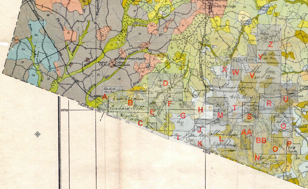
In closing, my last post pertained to my discovery of survey plats for James Battle who owned land near the Cumberland/Chatham County line along the Cape Fear River. In the next post, which may take some time to complete, I hope to present a similar map as that above for a streak of land connecting the Cape Fear to Wake County. In all of this, for me, my mind is always sighted based on the concept of birds of a feather. If Jacob and Joseph in Wake are truly my kin …they are, then friends etc.. who journeyed with them from where they earlier lived should appear somehow in the record as seen by way of plat maps.

In that many of our family was friendly and worked well with all races and creeds, would it be possible that some slaves or American Indians took the Thomas name as their last name?
This was common practice in the post Civil War era. Former slaves also adopted place names as their surname.
Hi cousin Dan, and thanks for the question. Certainly there are THOMAS in the area who descend from the slaves of our family. The surname is one used in the area by blacks though I have never seen anything binding the name to Native American heritage though I am sure there were times when parts of our family intermarried with both Black and Native Americans.
One thing you may consider – my research, if correct, in this geographical area has Asa being married to Pleasant Matthews who is the daughter of Joseph and ELIZABETH STEPHENSON. Pleasant was born around 1752. Joseph and Elizabeth were still married in 1753 when they deeded land to the Brewers. Ann was wife #2. Ann Jinks had three sons when she married Joseph. Hope this is of value to you.
Hi Billie, this is all interesting and may add to what I’ve found …thanks! Asa’s son David applied for a Revolutionary War pension on behalf of Asa’s service. In the documentation he states that Asa moved to Rowan where he died. I also found a deed in Anson County where Asa bought land and may have lived for a short period of time around 1800. Asa’s wife is mentioned in last will and testaments of the Matthews family and also witnessing deeds is Michael Thomas along with Voluntine Austin. Voluntine is believed to be a person of color. And, also living nearby in Wake is Hiliard Thomas who in census is identified as Free Person of Color. I have not found a tie from this family to Joseph Thomas, though they lived not far from each other.
Would love to hear more about the Ann and her Jinks sons….and where exactly the lands were that you mention. I will follow up on your lead about Joseph daughter, Pleasant. Virginia Crilley