 Lost or missing records are a major issue for those of us seeking to uncover our family histories. Most often records are destroyed by courthouse fires, floods, or even from hurricanes and cyclones. Many of the records needed to trace my own family in early Stokes County NC were destroyed by a “cyclone” that leveled the Surry County Courthouse in the 1830s. And beyond accidents and acts of nature, there is arson used by criminals of the day to destroy legally critical documentation. As an example, Mathew Cagle witnessed such a fire while he and his son camped near the courthouse in Moore County.
The Carthage Blade, 12 Sep 1889.
“…about two hours before the fire broke out I noticed a light about as large as a candle in the Register of Deeds Office. I thought nothing of the circumstance, and again went to sleep. The next thing I heard, my son called me and said the court house was on fire. I hurriedly ran up there and into the building and noticed that fire was issuing from the Register’s office door. I pushed the door, which was slightly ajar, open and saw a large pile of books burning very rapidly, as if saturated with oils or spirits turpentine.”
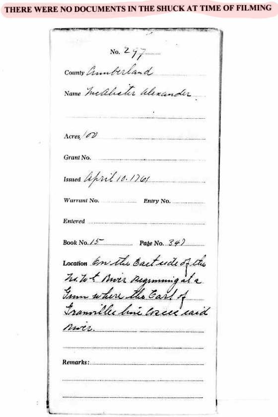
Looking at land records back to origin, a decision was made many years ago by our state to organize the piles of surviving colonial and Secretary of State issued land grants for safety and public consumption. Documents were collected, assembled, and placed into shuck-styled envelopes based on their origination as sequentially appearing in patent books as “entries”. As an example, see the patent book entry for Alexander McAlister below. Click on the image to enlarge and read carefully as this entry is important.

Shucks were arranged geographically by county with file numbers given to each entry. All related documents were placed into the shucks which included warrants, reassignments of land grants, surveys, and other related documentation.
 Sometimes the supporting documents were lost and never found with only the original entries in the patent books surviving. Of course you can’t place the patent book into a shuck so somehow the discrepancy needed to be communicated. In such cases of missing record, as appears to the right in the microfilm image of the shuck for the above Alexander McAlister, the patent entry for that particular grant was given a file number along with a brief description abstracted from the patent book. But of huge disappointment to people like me on the search, notice the red highlighted statement at the top which reads: “THERE WERE NO DOCUMENTS IN THE SHUCK AT THE TIME OF FILMING.”
Note that Alexander McAlister’s grant file no. 297 was located “on the east side of the N’t W’t River [Cape Fear] beginning at a gum where the Earl of Granville line crosses said river”. This is really important geographically and wouldn’t it be great if the original survey plat survived? Oh well … it appears at some point the state lost their copy of the document. You would believe that all is lost, and yet, guess what? …the original owner’s copy of the survey survives! It survives!
Beyond the numerous ways in which records became lost as outlined above, land granted to Alexander McAllister was impacted by a later occurring era of great industrialization built on the mining of forests, coal, and iron. Lost within the acquisition of huge multi-thousand acre tracts, title histories for many land grants in the region surrounding the Cape Fear River, such as that belonging to Alexander McAlister, are now lost to the world. And even today, brick manufacturing companies and the enormous Shearon Harris Nuclear Plant properties make it virtually impossible for the untrained eye to imagine what once stood on such sites. Within this reality, how can it be that Alexander McAlister’s land documents survive? And similarly, what do we know of the surrounding lands?
A fellow by name of Jonathan McGee Heck was responsible for locating and acquiring raw materials needed to sustain the Confederate forces. Following the war, and operating from his home in Raleigh (today being a major landmark in our city), J. M. Heck pursued northern industrialists to which end he met and joined with George Lobdell of the Lobdell Car Wheel Company of Wilmington, Delaware. George Lobdel manufactured train wheels during the war and afterwards, following evaluations of scavenged wheels from Confederate Fleets, the said Lobdell learned that a particularly hard grade of steel originated from iron mines located near Buckhorn Falls on the Cape Fear. At a time when the south was economically depressed, Lobdel and Heck took advantage of the opportunity though their efforts ended abruptly when the valuable veins of ore ran dry. Their holdings included a steam ship, furnaces, and many acres on the northeast side of the Cape Fear River.
Jonathan McGee Heck lived out his life in Raleigh where he died. Today his papers reside at the North Carolina State Archives. Going the extra mile in chasing my family’s loose ends, I decided to explore the collection. Among the papers are deeds and early communications related to the mining effort. And as appears below, the 1759 survey for Alexander McAlister’s grant can be found among the papers.
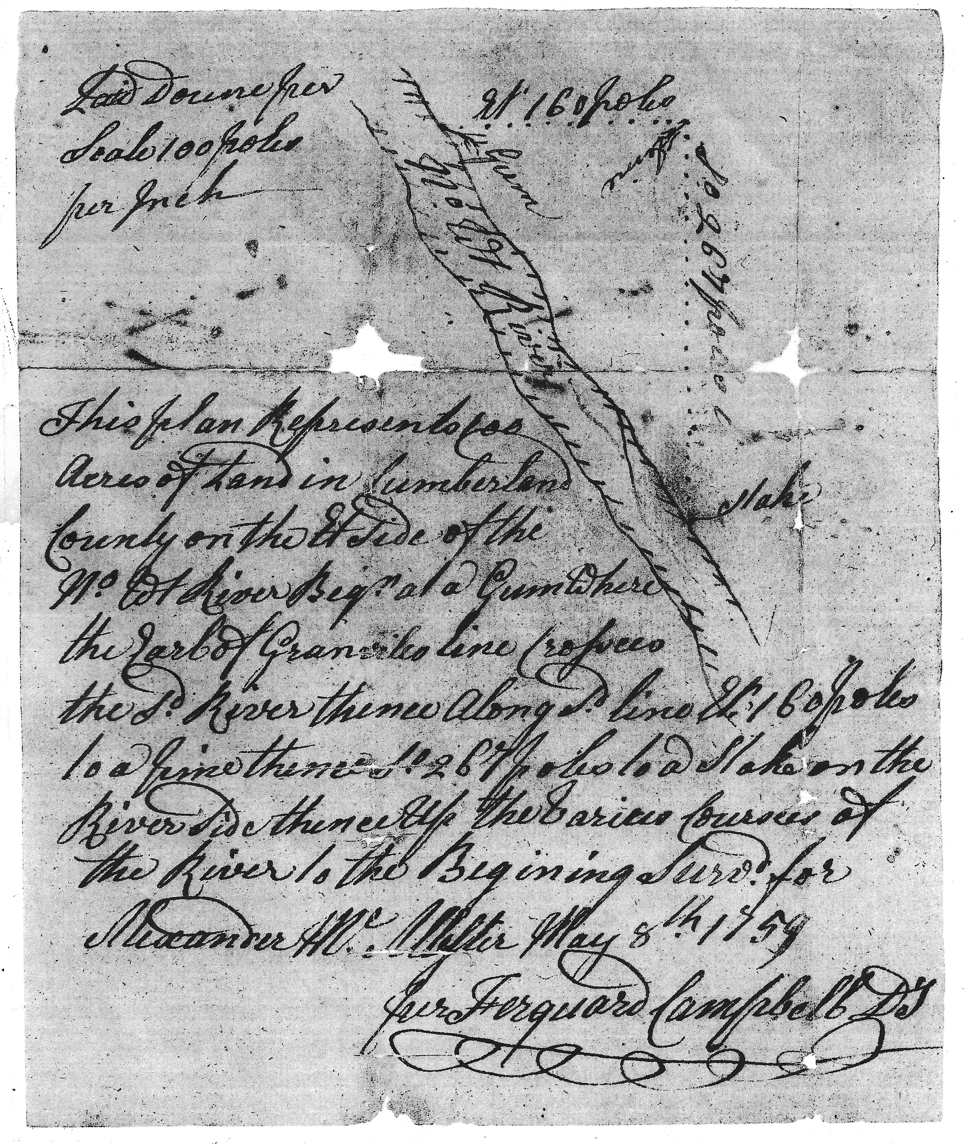
How cool is that! Not seen in any index or other format, and being lost as were many other grant documents from the time and area, Alexander McAlister’s original paper copy passed from his hand through successive owners before finally reaching the hands of Jonathan McGee Heck whose family wisely placed the papers at NC State Archives for preservation. The collection also holds the original 8 Nov 1761 deed of conveyance for this tract from Alexander McAlister to William Tully. Further title history for this tract is as follows:
- Deed 2-292, Cumberland, 1763, William Tully to Robert Perrygrove
- Deed 2-522, Cumberland, 1765, Robert and Febe Perrygrove to John Johnston
- Deed 2-608, Cumberland, 1765, John Johnston to James Brazier
- Deed 7-100, Cumberland, 1782, James Brazier to his loving son Elijah Brazier
Let’s take a closer look before leaving this particular tract of land. Referring to the survey, note that the Earle of Granville line once served as the southern boundary for the immense Granville Tract which took in nearly the northern half of our state. You’d think physical memory of that land would be lost by now however, unlike on the eastern side of the Cape Fear, the western side did not experience the same sorts of loss from industrialization. Also, and giving us a valuable bit of information, on the west side of the river, the Granville line served to separate old Orange from Cumberland County which later became Chatham and Moore Counties. Lee County was cut from Moore and Chatham in 1907 though today the remnant remains of the old county line, the Granville line, can clearly be seen as a horizontal anomaly in the quilt work pattern of modern day property lines as seen on the county GIS map below. See it?

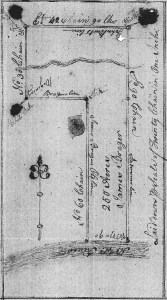
 Now that we’ve looked at the McAlister tract, let’s take a minute to explore another lost land grant document from Jonathan McGee Heck’s papers. Being land grant no. 2187 issued in Cumberland County, the 250-acre tract issued to James Brazer [Brazier] adjoins his own mill tract, being the above mentioned 100 acres originally issued to Alexander McAlister. The shuck for James Brazier’s grant is not empty though it ONLY contains the entry officer’s order to survey the land as seen to the right.
As with Alexander McAlister, James Brazier’s original copy of the actual survey passed through numerous landowners before finding its way to the collection of Jonathan McGee Heck. The actual survey goes further in depth than what was provided in the entry officer’s orders. The survey as seen below mentions the Granville line with the plat referring to the same as being “Brazier’s line”. Hugely important, the survey plat also identifies “John Burt’s line” to the north and “Anderson’s line” to the east. As for Anderson, a quick search of the Cumberland County Register of Deeds and land grant records at NORTH CAROLINA LAND GRANT IMAGES AND DATA, we learn that land grant no. 1437 to the east was issued in 1756 to John Anderson out of Bladen County. The grant was entered at a time before the formation of Cumberland. The shape and orientation of John Burt’s land to the north is a little more problematic in visualizing though look soon for updates related to this and lands of others who lived on what’s now the Harnett County line along the waters of Parkers Creek.

Bringing this post to closure, many from my extended family passed through the above lands. Knowing that every clue should be considered, and as will later be shown, locating this land at the foot of Buckhorn falls is an important step in figuring out the history of my early Thomas family.

Hello George,
Thank you so much for the incredible work you have done and providing us researchers some good leads. Some years ago, you were very kind in responding to some questions I had about the families of the Rocky River area. My ancestors were Fredericks. It is thought that Philip Frederick was the father of Hezekiah Frederick that would eventually move to Rutherford Co. Tenn. (My ancestor). The Frederick’s (Philip, John and Henry) lived at what is now the Sikes Mill Rd/Rocky River crossing in Stanley and Union Counties. Philip’s land “straddled” Rocky River. Frederick Tracts 8/9/40, from your very informative site: https://www.angelfire.com/nc/benjthomasofansonnc/southword.html
Be well
Dave Frederick