 Out of curiosity I posted the above on Facebook in hopes that someone in Stanly County might be able to identify the mentioned Union Grove Church. Google locates a church by that name in Albemarle, but nothing shows up in Furr township. Tammie Rabon Hudson responded to my post with “didn’t this church become Clark’s Grove near Stanfield?”…to which Tara Talley Tarlton replied “I found Union Grove Church on another- deed 27 page 458, James T Lee and James Taylor, 15 acres excluding church, in 1901. James T Lee gave the land to Clarks Grove Trustees in 1903.”
The online conversation led us to conclude that Union Grove Church predated Clark’s Grove and once stood on or near the site where now stands the defunct Clark’s Grove Primitive Baptist Church. Tara Talley Tarlton also mentioned a scheduled gathering in May at the old church. I understand the service has been cancelled or postponed due to the coronavirus pandemic.
__________________________________
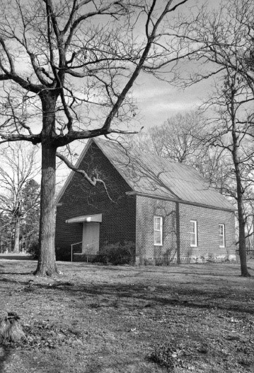 If you asked me for the best architectural example of a Primitive Baptist Church meeting house, I’d rank Clark’s Grove as being a classic and at the top of the list. Located in the southeast corner of Stanfield and situated on Hwy 200 and Webb Road, the old brick structure stands as a proud reminder of our past. The building stirs thoughts of Sabbath and of it being approached on foot and by wagons filled with the families of hardworking farmers dressed for worship. You can imagine the many feasts that have been spread under the grove of trees. And of course, we’re reminded of sadness and of those who gathered to bury their dead.
Today, technology gives us new looks at the old church. As seen on Google maps (red shaded in image 1 below), the church stands on the northwest boundary line of what appears to be a larger square shaped tract (yellow) that’s slightly askew. Looking for clues in the form of tree and fence lines, I ask of the reader, can you see how I was able to locate both the church lot and the larger square shaped tract? That’s a loaded question as the landmarks are hard to distinguish in this instance. So, let’s look at another source, the Stanly County Geographical Information System (GIS). Providing all the land boundaries for every ownership across the entire county, GIS is a hugely helpful resource for mapping land. Point in question, image 2 below offers yet another view of the lands surrounding and to the southeast of Clark’s Grove. As you can clearly see, boundary lines appearing in this view confirm the square shaped tract I’m looking for …and it’s this tract that reveals a great story that’s been lost to time.


In the GIS image above, you may have noticed that the larger square shaped tract has been subdivided numerous times in which I’m sure the various conveyances spanned what is likely more than 100 years. It’s in one of these subdivisions of that breakup that the church known as Clark’s Grove was founded. And it is somewhere nearby that an earlier church called Union Grove once stood. They may very well be the same church. That story has likely been told and as for me, I see no need in revisiting that aspect of the church history. Instead, I’m looking further back in time in hopes of uncovering some sort of cultural beginnings. I’m looking for events that if never happened, may have made it difficult for a church to be spiritually born. And now, it’s at this point in writing my post that I realize that much time has been devoted to the larger square tract without offering a clue as to why.
The history of the large square tract becomes known by way of information gleaned from the deeds of surrounding lands. Please look at the following GIS study which begins to tell the tale.

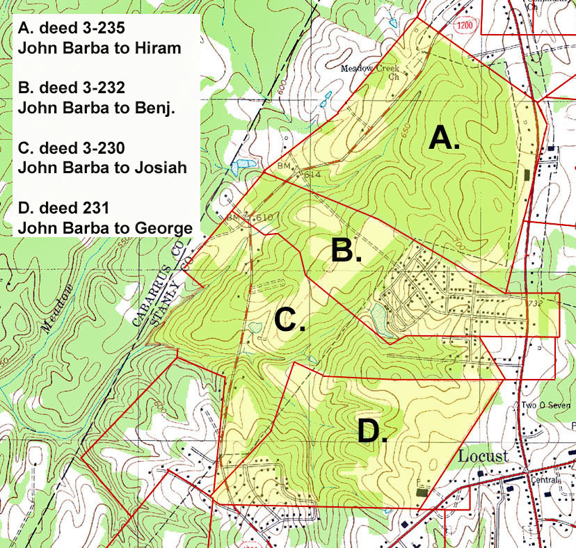
As for the green shaded tract above, its earliest known conveyance is in the form of an 1856 deed (6-280 Stanly) from Gabrial Barba to Brittain L. Green. At that time the land adjoined Mary Long to the north, George Cagle Senior and Lewis Springer to the east, and George Tucker to the west. A few years later, in 1861. Gabriel Barbee sold the purple and deep blue tract (6-280 Stanly) to Michael Dry. Gabriel’s tract adjoined Lewis Springer to the east, Drewey Morgan to the south, and again, George Tucker to the west. And, in 1857, Gabriel Barbee is recorded as selling the combined green and purple shaded tracts (4-315 Stanly) to Daniel Freeman. At that time, George Cagle’s land was described as “now occupied by Sarah Cagle, his daughter.” Also, George Tucker’s land to the west was described as “George Tucker’s line, now owned by the Greene family.” Looking a bit further into the future, in 1882 Michael Dry sold the blue shaped tract (28-468 Stanly) to L. C. and wife Maggie L. Ponds. At that time the tract was described as “adjoining the lands of John Furr, Wilson Furr, M. Dry, and others.” And as for the green shaded tract, Andrew Honeycutt later sold it to John A. Furr.
 Realizing the deeds above were pinpointing George Tucker land that had later been owned by the Greene family, I now had solid clues on the early history of the large square tract upon which now stands Clark’s Grove. Digging into my box of hand-drawn and unplaced land plats, I lucked out and found the following 1857 deed in which John Barba, Sabra Greene, Jacob Greene, and Elbert Greene of Cabarrus sold 152 acres (6-25 Stanly) to Israel Furr. You’d think that John Barba, or his wife, was one of the heirs within the Greene family. And, he and the others were possibly selling off their rights to an estate. And note that the boundary lines of the above green and blue tracts match up perfectly to those of this large square tract sold to Israel Furr. From all of this we now know that George Tucker once owned the land, it fell into the hands of the Green family, and was later sold by what may be the heirs
A succession of family members named George Tucker spread through Cabarrus and Stanly Counties. Second in the chain of the Tucker family is a George Tucker who owned land near the intersection of Love Mill and Honeycutt Roads. Sometime shortly after the year 2000 I met and traveled that area with Hellen Tucker Obermeier who happened to be the most knowledgeable person I’ve ever known on all things Tucker. She led me to Kinza Baptist Church where supposedly the old Tucker homeplace once stood. Helen carried me to the back corner of the cemetery where two gravestones lay flat and slightly below the ground level. Writing was visible though likely not for long as the cascading turf was quickly covering the stones.
Helen and I stood upon the hallowed grounds as she spoke of visiting the graveyard a few years prior. Not seeing the George Tucker grave, Helen and her daughter Diane began probing the turf till they hit rock. Together, the two cleared the stones from beneath inches of sod revealing the engraved markers for the first time in many years. On my visit with Helen I took pictures of the graves with my old film camera. Having the film processed, only the image of George’s wife’s grave was properly exposed (see below). Since that time, and not having a good picture of George Tucker’s grave, I visited the cemetery again in 2017 only to learn that the earth had once again retrieved the stones. I had no idea where to look and certainly did not want to get caught digging in the church lot. At that point I visited Helen once more and her daughter Diane printed copies of their pictures. And as luck would have it, I’ve somehow lost that set of pictures. And sadly, and further complicating the situation, I recently learned that Helen Obermeier passed away in 2019. And now, due to Covid 19 related restrictions, I dare not go south in search of locating the much-needed pictures for this post.


At this point I’m beating myself up and know that loss of such resources may be felt forever. But then two thoughts popped into my head. First, I remember my last visit to the church and of a conversation I had with a devoted member who was cutting the grass. The man said it would be great if the church at least had a copy of the photos. After receiving the prints from Helen, I dropped off a second copy with the fellow who was still at work. Maybe at some point I can get back to the church to inquire about those copies.
In my second thought I had an ah-haa moment upon realizing the importance of something I had heard during a recent presentation by cousin and mapping expert David McCorkle. Going to the Stanly County GIS site, I did the happy dance in learning that the technology gives you several aerial view choices. The land boundaries are overlaid on several optional aerial map images spanning numerous years. It so happens that one of the maps is based on images taken in 2005. Why is that important? Below you can see that in 2005 the stones as were visible to the satellite’s camera as they had been recently rediscovered and brought to life by my friend Helen.

Kinza Baptist Church
Born ca. 1764, George Tucker (Jr) is the son of George and Maria Dorthea Tucker who are buried on the east bank of the Rocky River at the end of Smith Road which is located about a mile north of Reed gold mine. During the 1830’s many from the area moved into the southwest corner of Stanly County. I’ve always thought one reason for the movement was due to damage gold mining had inflicted upon the land. The scarred landscape must have been an eyesore. And, there is also the fact that gold was later discovered along Rockhole and Island Creeks in southwest Stanly County. Did that play any role on the move? …likely so.
George Jr.’s sister Caterenah “Catherine” Tucker married John Barba (Barbee) who died in the 1870’s. John Barbee is buried at Meadow Creek Baptist which is near Reed gold mine. Caterenah’s grave does not survive. For me, there’s a confusing problem with this scenario as there is also an earlier “John Barba” buried in the same graveyard where George Tucker Senior is interred at the end of Smith Road. Who is he and how does he relate?!!!
In 1837 John Barba purchased land on Little Meadow Creek from George Linker. The deed was witnessed by George Tucker. In 1850 John and Catharine Barba are listed as living in Cabarrus County:

1850 Cabarrus County, North Carolina
And then during the early 1850’s John Barba deeds his lands to his sons. Located north and west of present-day Locust. There is no deed or grant of origination for the lands of John Barba.

In 1855, John Barba and others disposed the lands (4-137 Stanly) of Malicha Harwood, deceased. Below are all those who are listed as sellers in the deed along with the implied names of the wives’ parents:
• William Eudy and wife Sabra (daughter of Malachi and Sabra Harwood)
• Hastin Hatley and wife Bathsheba (daughter of Malachi and Sabra Harwood)
• Jacob Green and wife Mary (daughter of Malachi and Sabra Harwood)
• Daniel Lowder and wife Elizabeth (daughter of Malachi and Sabra Harwood)
• Edmond Whitley and wife Susannah (daughter of Malachi and Sabra Harwood)
• Paul S. Furr and wife Sarah (daughter of Malachi and Sabra Harwood)
• Wiley Hatley and wife Mazah (daughter of Malachi and Sabra Harwood)
• Hardy Green and wife Abigail, heirs to wit: (daughter of Malachi and Sabra Harwood)o John Barba and wife Foreba (daughter of Hardy and Abigail Green)
o Caleb Osborn and wife Mary (daughter of Hardy and Abigail Green)
o Martha Green (daughter of Hardy and Abigail Green)
o Sabra Green (daughter of Hardy and Abigail Green)
o Jacob Green (son of Hardy and Abigail Green)
o Elbert Green (son of Hardy and Abigail Green)
The above is important in that the deed identifies Foreba (Phoebe, Fereby?) and Mary as being daughters of Hardy and Abigail Green. Also, Martha, Sabra, Jacob, and Elbert Green are identified as being the children of Hardy and Abigail. It is probable that Abigail passed by the 1855 dated deed as why else would her children be listed as heirs? A little background info on Hardy Green …he and a brother Jacob are sons of Jacob Green who lived and died on Grassy Creek in Anson/Union County. The elder Jacob is likely a brother or at least contemporary of Gideon Green who I have researched heavily in the past. Hardy was born ca 1795 and his brother Jacob was born ca. 1800.
Hardy is a bit of a mystery as in 1850 he fails to appear in census records as living along our Rocky River. His brother Jacob is 57 years of age and living in Stanly County. At that point, Hardy Green is listed as 60 years old and living far away in Burke County which is in the western part of our state. Others from the Rocky River region living near Hardy include James Gurley who married Mary Keiser, the daughter of George Keiser of Cabarrus. Of note, James and Mary’s son Thomas Dove Keiser was one of the wagon masters for the first Oregon Trail crossing. And, after confirming the deed naming Hardy’s wife, note that Abigail had likely passed by 1850 as she does not appear in the census. Also confirming the deed, the census lists Hardy and Abigail’s children Fereby, Jacob, and Elbert Green.

1850 Burke County, North CArolina
After 1850 Hardy Green and his family returned to Stanly County where they are mentioned in the deed for the large square tract. Do you remember that? Dated 1857, John Barba, Sabra Greene, Jacob Greene, and Elbert Greene of Cabarrus sold 152 acres (6-25 Stanly) to Israel Furr also of Cabarrus. For sale is the tract upon which now stands Clark’s Grove Baptist Church. And, occurring before this sale by the heirs of Abigail Harwood Green, at some point prior the land had been owned by George Tucker who is likely the same George Tucker whose home once stood on the grounds of present day Kinza Baptist church.
So, now we have a bit of context as to the identification of the sellers of the important large square tract. However, before continuing, I’d like to expand the story a bit further. As you may recall, Mary Long is identified as owning land to the north of the large square tract. The land was at one point owned by Thomas Long who I suspect is linked to the Long family who intermarried with my Love family in eastern Cabarrus. Also, owning or making improvements on the same lands are James Crump, Henry Goodnight, George Cagle Senior and daughter Sarah, L. L. Furr, and Solomon Pless, and Philas Hartsell. Mary Long’s land was adjoined by that owned by Brittain L. Green, Holden Hartsell, Eli B. Honeycutt, and Murphy Hopkins. Expect more on the Mary Long tracts in the future.
Before moving forward, you need to know that in 1861 Mary Long, Melinda Green, Jacob Green, and Susan Long now “of Pope County Arkansas” sold 25 acres (deed 6-290) to W. F. Moss. On the next page in the deed book, and occurring in 1874, Mary Long, George Long, Louiz Long, and Melinda Green “of Ripley County Missouri” sold another 45 acres (deed 6-290) to W. F Moss. These folks appeared in the 1860 Pope County census as seen below. And, you will note that among those living in the household of Mary Long are Elbert Green aged 26 and Jacob Green aged 30, the sons of Hardy and Abigail Harwood Green.
1860 Pope County, Arkansas
And Hardy Green, the father of those who moved to Arkansas, did not make the trip west. In 1860 Hardy Green is listed as living in southwest Stanly County. He is without wife Abigail but note that daughters Sabra and Patsey are still living at home with their father:

1860 Stanly County, North Carolina
__________________________________
I began this post with an 1897 deed from Michael and wife Mary Dry to M. T. and wife S. E. Hartsell. The ill-defined 50-acre tract adjoined the lands of J. A, Furr, Wilson Hartsell, Franklin Teeter, J. T. Lee, and Mathias Furr and was also described as “lying near Union Grove Church.” We know that in 1901 James T. Lee donated land for use by Union Grove Church and then in 1903 he gave land to Clark’s Grove Church. And, this land lay within or adjoined the 152-acre large square tract that once belonged to George Tucker.
We know that George Tucker also had land and a homeplace along present day Love Mill road at the site of Kinza Baptist Church. As a matter of fact, the church cemetery sort of merges with and becomes one with what was once the burial ground for the George Tucker family. And, we know that George Tucker is the brother of Caterenah Tucker who married John Barba. They lived north and west of Locust where John gave land for Meadow Creek Baptist Church. Their son Gabriel Barba happened to own land adjoining the large square tract south of Stanfield. that was once owned by George Tucker. There was also Hardy and Abigail Harwood Green’s daughter Foreba who is mentioned in a deed of conveyance for that tract of land. We know by the deed that Foreba married a John Barba who is likely connected to the John and Caterenah Tucker Barba family. And in all of this, I cannot prove the origin of Union Grove Church. I cannot with certainty find a spiritual tie that binds this story. I can, though, encourage Kinza Baptist Church to embrace a past that includes the story of George Tucker. And likewise, the story is likely not known at all as connects to the lands where Clark’s Grove Church now stands.
In closing, I hope that the deadly virus will one day be behind us. I hope that the church community will once again gather to fellowship on the grounds of Clark’s Grove Baptist Church. I also hope that the life and stories of those who came before will be better understood and shared. They were truly spiritual people and I feel their life achievements had a part in shaping the religious landscape.
And, as for Kinza Baptist, I’ve always been curious why there seems to be a an aire of exclusion in maintaining the memories of a past worth remembering. The George Tucker graves deserve a more honorable presentation. Does the church body have concerns of encroaching upon the hallowed grounds? If so, why not at least place a bronze plaque and corner stones to mark the hallowed space. I’d like to once again see the hidden stones rise again. But then again, I know they have survived and been protected for many years lying just out of reach of human sight and touch. Do we dare risk history? Where do family stand and what do you believe?

If u wanna see a picture of a old Baptist church look at the web page of mineral springs church near oakboro on hwy 205 it was located on what was austin road in that time
Another great post that offers so many clues on Cabarrus George Tucker. I’m almost sure he had a grandson named James Tucker (Y-DNA proves a family connection) but am having a difficult time placing James in this family. I also think this James married Milly Hartsell and they migrated to Eldorado, Montgomery County around 1840. Another James Tucker married Jane Russell and I think this James is probably George’s son. James and Jane also went to Pope County, Arkansas with a lot of Cabarrus families, including a Love and a Petray family. Thanks much for the info about George. I now have more clues to follow.
Hey Cynthia, I’ve seen numerous Tucker family spread out in areas of Stanly I would have not suspected. Will keep an eye open for James and Milly. At present I’m working areas around Jacob Hartell and others on Island Creek
Thanks for posting this. My great grandfather was James Lee. My grandfather was Webster Jonas “Webb” Lee (Webb Road was named for him). He gave my mother and dad the small part of the Lee acreage west of Morgan Mill Road for their home site, so I grew up almost directly across the road from Clark’s Grove Primitive Baptist Church. I remember my grandmother, Vashti Huneycutt Lee, telling of the services, dinner on the grounds, “foot washings”, etc. at Clark’s Grove. I remember the Sunday services were held at Clark’s Grove every fourth Sunday. On the other Sundays, services were held at other Primitive Baptist Churches in the area.
My grandparents Douglas and Nann Bratton are buried on the last row, at Clarks Grove church.
I also buried my Mom’s ashes there too, beside my close relatives are also Dorman (uncle and aunt) Teenie Bratton. On the same row are Philas Hartsell (who was raised with my grandmaw) and his first wife.
I went to many funerals with my grandmaw at Clarks Grove, also the bookmobile will park there for everyone in the neighborhood to check out books for several weeks reading.
I lived with my grandparents down which is Harvell Road now, about 3/4 a mile.
Do you by chance have any more information on John and Catarenah Barba? They are my 4th great-grandparents and I cannot find who John’s parents were. I am also very interested in the other John Barba who is married to Foreba Green. I cannot locate any information about them. Thank you for the this story, it is so interesting to read about my ancestors.
Thank you for your response, but those records go dim and I can only imagine the family being part of a line possibly in Chatham or Orange Counties.
Hello. You referenced Henry Goodnight in this post. Do you have any other notes about the Goodnight’s, particularly after 1762? I know they were along the Mecklenburg Co side of Rocky River when they originally came to NC.