 There’s a William Howell Taylor, a William Harvey Taylor and numerous families from North Carolina, Tennessee and even Indiana claim persons named William Hudson Taylor. As a matter of fact, I remain gobsmacked in learning that a possibly related William Hudson Taylor is buried at Arba cemetery in Randolph County Indiana. I remember back in the 1990’s driving out one foggy morning through the broad corn fields on my way to this cemetery. It was my intentions to learn more about a Quaker line of Thomas once believed to be my kin. I learned that Benjamin Thomas interred in the cemetery is not my kin, but some say William Hudson Taylor who is buried there …just might be. He is believed to be the son of Hudson Taylor Senior of now Stanly County North Carolina. How did this guy end up in Indiana and what’s his story!!??
Over the next few months I’ll be pondering the Taylor family; of complicated bits of a story even more tangled by the nature of land records along the Rocky River here in North Carolina. And, as for this post, I’d like to share with you a most amazing court case. Raised by Doctor F. Mann against William H. Taylor, the suit offers a glimpse into family lands while carrying the most studious of us back to the earliest days to the backwoods of western North Carolina. The story also links us to an important time and to the family who was first in America to make a profit mining gold.
___________________________________________
Indebted in the sum of $28.80; a cow, a calf, and a rifle gun were conveyed by Hudson Taylor to William H. Taylor on 15 Mar 1843. The transaction was witnessed by Isaac Biles who must be related to Hudson Taylor Senior’s daughter Dovey who happened to marry Alexander Biles.
And then, dated 23 Jan 1854, Daniel Freeman sold to W. H. Taylor 174 acres (3-314 Stanly) situated “on the fork of a branch.” The land was originally part of a huge tract granted to speculators Thomas Carson, William Moore, and Barnabas Dunn. Within the body of the deed, W. H. Taylor is referred to as “Howell Taylor.”
Rising out of the Stanly County Superior Court in 1854, a suit of ejectment filed by Dock F. Mann against William H. Taylor reached the North Carolina State Supreme Court. At issue was the grounds and validity of an ancient ten year agreement pertaining to the above 174 acres. At the time of the suit, the 174 acres was identified as adjoining the lands of George Reed, brother of Conrad Reed who’s credited as the first non-native person to discover gold in America.
In locating the 174 acres, an earlier conveyance from Stephen Kirk to Thomas J. Shinn was offered as evidence. Dated 13 Aug 1833, Stephen Kirk sold a whopping 1,999 acre tract excepting 200 acres which had been deeded to Tucker and Shinn. Further depositions in the case show the 1,999 acres later fell into the hands of one Hartsell before being sold to Doctor F. Mann.
From the metes and bounds, we know the 1,999 acres lies upon “the waters of Reedy Branch” with one corner being described as “a persimmon in the line of Tract 2.” Then, running southerly, the next line ends at Shinn’s, Smith’s, and Tucker’s corner. Emphasis on placing the disputed land along what’s referred to as Great Tract 2 is crucial and a point that I believe may have been played in error.
Also brought into evidence, the above deed lies within an Aug 1745 grant of 12,500 acres to Arthur Dobbs of Castle Dobbs, Ireland. The 1,999 acres had been subdivided from the tremendous 12,500 acres and in 1745 was described as being located on Johnston River (now Rocky). The tract was but a small portion of twelve 100,000 acre tracts totaling 1,200,000 acres all together.


The defendant, William H. Taylor, introduced David Kizor who swore in testimony:
“…that about some 40 years since [aprox. 1814], he was present at the trial of a suit in Cabarrus County court & then heard one Love who was sworn and who is since dead & who testified on said trail in Cabarrus that there was a post oak marked as a corner at the Gum Pond and that the post oak was said to be a corner of tract number two of the Big Survey.
William Stancel, a surveyor testified he had surveyed the land in controversy & began as directed finding no corner there or pointes, and then east on an old marked line towards the Gum Pond – that the line looked old though he did not box any trees – and said marked line did not continue the length of the line he was surveying for the plaintiff, but only part of the way and he found no corner at the gum pond.”
The court ruled against a new trial based on:
1. Upon the ground that the Dobbs grant was void upon its face for uncertainty & could not be located
2. That the evidence was not sufficient to locate the Dobbs Grant
3. That the proof as to the seven years possession by the plaintiff & those under whom he claimed was not sufficient
At Superior Court, a new trial was refused, the rule discharged & judgement was made for the plaintiff. The defendant, William Howell Taylor, prayed an appeal which was granted. I’m not sure how the Supreme Court case ended though it seems the archaic stipulations from the 1745 grant along with the inability to properly locate the land would have played an evidentiary role in determining the outcome. I believe the Doctor F. Mann won the battle in court.
Let’s take a look at some of the Taylor lands, particularly those related to the case. Let’s look at William Howell Taylor, his family, and his parents Hudson and Rhoda Kettle Taylor.
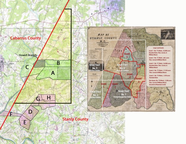
The huge yellow tract shown above represents the 1,999 acres sold by Stephen Kirk to Thomas J Shinn. The tract’s visual portrayal north and south along the Cabarrus line should not be considered perfectly accurate. However, I’m sure it’s location is close enough for this discussion. Note from the legal description below that the northern boundary (north of present day 24/27) adjoins “Tract 2.” For sure, that statement refers to the east/west dividing line running between Great Tracts 2 and 5. As a matter of fact, study the inset map above and you should be able to place the 1,999 acres as being in the extreme northeast corner of Great Tract 2.
The title history below represents the breakup of the 1,999 acres along with the land (in GREEN) that was at center of Doc. F. Mann’s law suit. A deed from Thomas J. Shinn to Conrad Reed [the little boy who finds gold while playing in nearby Little Meadow Creek] is identified in green as being tract A above. Looking below, you’ll notice that both Doc F. Mann and William H [Howell] Taylor claimed ownership of the same piece of land. The eastern half (checkerboarded) of Conrad Reed’s land (Tract “A”), being the disputed land, seems to adjoin the north to south dividing line between Great Tracts # 1 and 2. Take a look at the inset image above. However, I’m not so sure as grants and other deeds indicate the boundary line should run very close to Hwy 200. Something is amiss. Anyhow, take a look at the following:
Deed 4-2 Stanly, 13 Aug 1833, reg. Aug 1854. Stephen Kirk to Thomas J. Shinn, being 1,999 acres on the waters of Reedy Branch except 200 acres deeded to Tucker and Shinn. Beginning at a stake in the county line and runs with the line north 26 east 1120 poles to a persimmon in the line of tract #2 in a field, then east 120 poles to a white oak Shinn’s, Smith’s, & Tucker’s corner, then their line south 1100 poles to John Forest’s corner, then along his line west 520 poles to the beginning. Wit: Littleton C. Shinn, P. Kirk.
Deed 3-357 Montgomery, 22 Oct 1833, reg. Jun 1854. Thomas J. Shinn of Montgomery to Conrad Reed of Cabarrus being 370 acres on Rockhole Creek. Beginning at a pine near George Reed’s corner, then 320 poles to Shinn’s, Smith’s & Tucker’s line, then with line south 174 poles to a Spanish oak in said line at the fork of two branches, then west 180 poles to a stake near a road in said Reed’s line, then north 47 west 90 poles to a stake in said Reed’s corner, then his line south 60 west 108 poles to a stake in Reed’s line, then south 47 east 14 poles to a stake in said Reed’s line, then west 98 poles to said Reed’s line, then north 42 poles with said line to a red oak, a corner of said Reed’s, then north 30 east 64 poles to a white oak a corner of said Reed’s & George Reed’s corner, then north 48 east 118 poles to the beginning. Wit: James L Reed, James M. Shinn.
Deed 3-364 Stanly, 18 Feb 1836, reg. 26 Jun 1854. Paul B. Barringer to John Reed, being 174 acres, part of the lands of Conrad Reed deceased joining the lands of George Reed and No. 2 in the division of Reed’s lands. Wit: James M. Shinn.
Deed 3-363 Stanly, 25 Nov 1836, reg. Jun 1854. John Reed to Andrew Hartsell, being 174 acres (known as #2 of Conrad Reed dec’d) beginning at George Reed’s line then running south 174 poles, then east 160 poles to a red oak, then north 174 poles, then west to the beginning. Wit: George Barnhardt, John P. Craton.
Deed 3-384, Stanly, 27 Jun 1854, reg. Sep 1854. Andrew Hartsell to Doc F. Mann, being 174 acres known as #2 of the division of Conrad Reed deceased lands. Wit: Joshua Hartsell, A. Honeycutt.
Deed 3-314 Stanly, 23 Jan 1854, reg. Feb 1854. Daniel Freeman of Stanly to W. H. [Howell] Taylor of Cabarrus. Being 170 acres, a part of a large tract granted to Thomas Carson, William Moore, and Barnabas Dunn. Beginning at a stake, Spanish oak, and post oak at the fork of a branch, and runs west 152 poles to a stake, hickory, & black gum; then north 170 poles to a stake, Spanish oak, black Jack and two post oaks; then east 152 poles to stake by two red oaks & sassafras; then south 1 west 177 poles to the beginning. Wit: A. C. Freeman.
Note that the above tract was indeed subdivided from the 1,999 acres of which the northern most line is referred to as being “the line of Tract 2”. But, the division of Conrad Reed’s land is further south and does not join the Great Tract boundary line. Instead, the title history for the subdivided 1,999 acres consistently mentions George Reed’s land along with the line of Conrad’s Tract # 2. In my humble opinion, I think the legal action occurred in error out of a confusion between a line in the Great Tract #2 and tract #2 of the lands of Conrad Reed deceased. But wow, even if so, look at what such a simple mistake offers us! And, before leaving the “green zone” of this story, please take a look at tract “B” located to the north of Conrad’s land. It’s the lands of Conrad’s brother George frequently referred to in the above title history:
Tract B – Deed 3-239 Stanly, 26 Oct 1833, reg. Feb 1853. Thomas J. Shinn to George Reed, being 217 acres on Rockhole Creek and Daniels Branch. Beginning at a pine (dead) near a road in George Reed’s corner, then east 320 poles to a stake in a field, Shinn’s, Smith’s. & Tucker’s line, then their line north 112 to a stake, then west 38 poles to a stake, then south 6 west 10 poles to a stake, then south 84 west 158 poles to a stake, then north 6 east 15 poles to a stake, then west 140 poles to a black oak in said Reed’s corner (known by the name of Howell’s corner), then south 112 to the beginning. Wit: R. Shinn, James M. Shinn.
In reading the above, did you notice the red flag? We know from deeds that William H. Taylor’s middle name is Howell. And, here, upon the land nearly adjoining the said Doc F. Mann’s disputed tract is a corner known as “Howell’s.” Wow! So, who is this Howell person and does he have a place in our story?
Deed 13-787 Mecklenburg, 8 June 1785, Thomas Harris Esq. Sheriff to Joseph Howell. Being 100 acres of Dr. David Oliphant’s land “within tract 2” and situated on the east side of Rocky River. Beginning at a black oak and runs north 84 west 146 poles to a black oak, then north 21 west 68 poles to a pine, then north 52 east 88 poles to a black oak, Frederick Kiser’s line, then east 120 poles to a stake, then to the beginning. Wit: William Supples, Charles Harris.
Deed 5-20 Cabarrus, 7 Jan 1804, reg. Jan 1804. Joseph Howell to John Reed. Wit: James Love, Jonah Love.
Being the dark shaded cross hatched area in “C” above, note that Joseph Howell’s land fell into the hands of John Reed, father of Conrad and George. It’s easy to imagine the land as later belonging to John Reed’s sons. And then, in 1854, Joseph Howell’s 100 acres is sold as being part of a larger conveyance to Henry Yow:
Deed 23-280 Stanly, 27 Mar 1861, reg. Sep 1898. L. G. Heilig & J. M. Harkey of Cabarrus to Henry Yow of Stanly. Being 250 acres of “land upon which the widow of George Reed Dec’d has a dower assigned to her.” Beginning at Rocky River at Howell’s Branch, then up said branch 58 poles to a stake by 2 white oaks, then north 55 east 15 poles to a black oak, then east 136 poles to a black oak and red oak, then south 8 west 5 poles to a post oak, then south 8 west 110 poles to a pine stump corner, a corner of No. 2, then south 57 ½ west 118 poles to a white oak, then south 77 west 193 to a small pine in Rocky River, then up the river to the beginning. Wit: Henry Reed.
So, at this point we clearly see why George Reed’s tract “B” above would mention “Howell’s Corner.” And, we now know the stream which anchors tract “C” on map is named “Howell Branch.” I’d like to be able to declare that William Howell Taylor is somehow related to this much earlier Joseph Howell. However, I don’t have that answer and will leave its discovery to others. For now, let’s turn from the Green Shaded Tracts to the Red Shaded Tracts reflecting the family of William Howell Taylor.
We believe that Hudson Taylor Jr. married first to Elizabeth Howell whose relation to the above Joseph Howell is unknown to me. I believe William Howell Taylor is the son of Elizabeth and therefore carries the name of her family.
Following the death of wife Elizabeth, records show that Hudson Taylor Junior shared financial interests with a lady named Rhoda Kettle. It wasn’t until a considerable amount of time after being identified with Hudson that Rhoda actually married Hudson Taylor Junior. I’ve been unable to locate Rhoda’s parents though I wonder if her name is correct? You see, her lands are located close to George Kestler and others of that surname. Though a stretch of imagination, is it possible Rhoda’s maiden name is Kestler?
Take a look below at the information on the lands (Shaded Red) in western Stanly County belonging to the family of Rhoda Kettle and Hudson Taylor Jr:
Tract D: Grant 1729 Montgomery, ent. 8 Apr 1803, iss. 16 Mar 1805. Issued to Henry Kagle, being 145 acres on Camp Branch of Rocky River including his own improvements.
Deed 1-229 Stanly, 20 Feb 1844, reg. Nov 1844. Jere Adderton to Rhoda Kittle being 81 acres on Camp Branch of Rocky River and is part of a tract originally “granted to Henry Cagle in Oct 1803”. Wit: G Shankle, Isaac Biles.
Deed 6-449 Stanly, 30 Aug 1867 reg. Sep 1869. Rhoda Kettle to Allen Helms both of Union County. Wit: Green B. and William A. Helms
To the south of the above is a tract “E” above which was sold by Rhody Kettle to Edwin Taylor. Edwin is believed to be the son of Rhoda and Hudson Taylor Junior. Note that Rhoda still uses her maiden name which raises questions as to her marital status. And, I’ve found no record indicating how Rhoda acquired Tract “E”:
Tract E: 9-80 Stanly, 15 Apr 1862, reg. Sep 1873. Rhody Kettle to Edwin Taylor, both of Stanly County. Being 126 ½ acres joining Laban Little, Levi Furr, and Jacob W. Little. Wit: Adam P Furr, John D. Taylor.
To the west, on the east bank of Rocky River, William Howell Taylor received a portion of land originating with John Polk before passing through the hands of Henry Cagle and the division of Frederick Kiser’s land. Identified in the illustration above as Tract “F”, the land adjoins the western lines of Rhoda Kettle’s land:
Tract F: Deed 7-182 Cabarrus, 24 Dec 1800. John Polk to Henry Cagle. Wit: Wm. Polk.
Deed 11-77 Cabarrus, 20 Aug 1828. Henry Cagle Sr. to Henry Cagle Jr.
Deed 11-335 Cabarrus, 20 Aug 1828, reg. Jan 1831. Henry Kiser to Frederick Kiser being 200 acres. Wit: Wm. Creaton, David Kiser.
Deed 24-169, Cabarrus Spring 1839, reg. Sep 1872. Division of Frederick Kiser Deceased. Being Lot # 2 of said division to Emily Edmunston.
Deed 6-13 Stanly, 29 Dec 1859, reg. Sep 1861. Laban Zebulon M Little of Mecklenburg to William H. Taylor of Cabarrus, being 80 acres on the north side of Rocky River in both Stanly and Cabarrus Counties. Attest: L. A. Russell, C. H. Polk.
Adjoining Henry Cagle’s Tract “D” to the north, Edmond and Catherine Bond received two grants in 1842. They are:
Tract G: Grant 21 Stanly, iss. 22 Oct 1842. Issued to Edward Bond, being 100 acres on Camp Branch adjoining Jacob W. Little and the Kizer tract along with David Kerr and Thomas Pinion.
Tract H: Grant 20 Stanly, iss. 22 Oct 1842, Issued to Catherine Bond, being 100 acres on Camp Branch adjoining Edward Bond, Thomas Pinion, Benjamin Pinion and Jacob W. Little
Edward and Catherine Bond moved to Cabarrus County with no deed showing the sale of their grants. And then, in 1854, Nelson Taylor, sold a large tract of 274 acres in which the two Bond grants can be placed. Who is Nelson Taylor?
Deed 4-54 Stanly, 29 Nov 1854, reg. Dec 1854. Nelson Taylor to Daniel Freeman, being 274 acres on Camp Branch. Beginning at a stake, three black jacks and pine, then west 11.75 chains to a stake by post oak & dog wood in J. M. Little’s line, then north 10 chains to a small red oak (his corner), then north 45 west 6.5 chains to a hickory, post oak, & red oak, then with his line west crossing Camp Branch 29 chains to a post oak, dogwood, red oak, then north 65 west 4 chains to a stake by three red oaks (Little’s Corner), then north 40 east 47.25 chains to a black jack, small hickory, and pine, then (with Drake’s line) east 51 chains to a small pine near a branch two pines and post oaks, then south 40 chains to a small post oak (in Jonah Love’s line), then with Jonah Love’s line south 80 west (Crossing Polk Road) 20.5 chains to a post oak, then south 50 west 8 chains to a post oak above the wall spring, then to the beginning. Wit: . O. Ross.
___________________________________________
Born ca. 1825, from estate records we know that William Howell Taylor married Mary, the daughter of Solomon Hartsell. Both Mary and her husband W. H. Taylor are mentioned in Solomon’s loose estate papers. There are several articles in the newpspers about Howell Taylor. In one, he was charged with illegally selling alcohol while another the burning of his barn and livestock. Howell Taylor lived a long life and died 10 Sep 1906 according to what’s found on findagrave. There, it says that W H Taylor and wife Mary are buried at Love’s Grove UMC. However, a newspaper article out of Salisbury marks Howell’s death as being a year earlier. The following appears in the Carolina Watchman:


Curious what other info you have on William Howell Taylor’s father Hudson?
I am a descendent of James L Hartsell and Elizabeth Betsy Taylor (2nd GG parents – both buried at Love’s Chapel UMC). I have hit a dead end on Elizabeth Betsy’s parents to-date. However, I have noticed that Hudson is on the immediately preceding 1850 census page from James L and Betsy. James L and Betsy were likely married ca 1835 so there is no other census data linking her parents. A probate search of Stanly Union Cabarrus and Mecklenburg have so far not yielded any clues. But I find the proximity of Hudson to them in 1850 tantalizingly suspicious.
It appears Hudson moved to Union Co in later years to live with other children. Note death certificates of Betsy’s children show her birth in either old Mecklenburg or Montgomery Co prior to formation of Union or Stanly proper.
There are many online trees that show Hudson had a daughter Elizabeth Jane “Betsy” Taylor who married to Henderson Love and Jonah Askew Love. Gosh the names are again tantalizing close. I have not been able to marry up supporting documentation from those trees to affirmatively attribute that Betsy to Hudson.
So – if you have any other info on Hudson and his family I’d be most appreciative? I’m hopeful maybe it is found in property transfers from Hudson to his children prior to and subsequent to his death.
Just to let you know, I’ve found your web site extremely useful with my other ancestors from the neighborhood – Dock Mann, Malinda Love, et al. Your work is meticulous and entertaining…
Sincerely,
Steve Carrick