City Limits
Elijah Spencer could not have been fully aware of the impact his crime would have on future generations. In 1843 he set fire to the Montgomery County Court House. As for land records, only a few dozen charred pages pulled from several deed books survive. And out of the loss are but a hand full of surviving records from which the founding of Stanly County has been built. Stanly was formed from Montgomery in 1842.
 I find it remarkable that the survival of at least one such old conveyance, has withstood the testament of time as is evidenced by what can be found on modern maps. Take a look at the image to the right and you’ll see the tract in question in red. Note that I drew the tract on the map and it’s not placed where it is actually located. If shifted to the right the red tract mates up with the Google image showing the town of Stanfield.
You see, towns set their perimeter limits based on what the community leaders believe to be the largest area tolerated by the citizens. There’s a lot of political push and pull and it’s a matter of how much the town officials can rightfully get away with. As the town boundaries push outward they meet up with the lands of prominent land owners who are important enough to push back on the advancement of the town upon their personal lands. It’s in that manner that town limits are usually irregular in shape, often modelling the metes and bounds of large surrounding farms.
There are clues hidden among the battles over control of land. The above red shaded tract represents an 1838 conveyance from Michael and wife Sally M. Garmon to John Little. Situated on Rockhole Creek the land adjoins that of Moses Osborne (to the south). Also, to the north this tract adjoins the lands of Jonah and his wife Mary Garmon Love. As Mary is the daughter of Michael and Sally Garmon, this is pretty cool in that it shows the elder Garmon’s once lived next door to their daughter and her husband.
My point? Even within the lines of the city limits there may be clues as to your genealogical past!
__________________________________________
Dirt Roads
In southwest Stanly County Nance Road runs west (outlined in pink below) before dead ending on Pine Bluff Road. Letting your eyes gaze further west, a black double dashed line indicates the continuance of a dirt road before coming to an end after bending south near the banks of Rocky River. Most folk have no clue as to the story this old dirt road tells. It actually outlines one of the boundaries of the land once belonging to Conrad Reed. Conrad is the little boy whose find in Little Meadow Creek initiated the first gold rush in America. He married Martha Love, his next door neighbor.
In August of 1833, Thomas Jefferson Shinn purchased from Stephen Kirk 1,999 acres (Deed 4-2 Stanly NC). A break-up parcel of Arthur Dobbs’ old Great Tract #2, this land deeded to Shinn is identified as lying on Reedy Branch. A very large piece of land, the tract runs the county line from Love’s Grove to near present day Hwy 24/27. Within the bounds of this tract, and dated 27 May 1828, the above mentioned Conrad Reed purchased 305 acres from Frederick Kiser (Deed 12-85, Cabarrus NC). The metes and bounds are as follows:
(Shaded Yellow Below) Beginning at a hickory, a corner of Catherine Reeds then north 65 east 118 poles to a white oak her corner, then north 16 east 36 poles to black oak her corner and David Kiser’s, then the division line south 71 east 308 poles to a pine n the out line the out corner, then Cheek’s line south 57 west 59 poles to a post oak sd/ Cheek’s corner, then south 50 west 42 poles to a black oak, then north 75 west 152 poles to a post oak, then north 86 west 19 poles to a stake in the branch called Reedy, then the meanders of the branch 174 poles to the river, then up the river to the beginning. Wit: John Barnhart, George Reed.
When drawn, scaled, and overlaid to the topographic map, the tract and its relation to the old dirt road becomes clear. Not only does the road enable us to accurately locate Conrad Reed’s land, it adds to the story of one of Stanly County’s most unique residents.

Note that in my last post I mentioned the lands of Henry Love. Dated 21 Dec 1881, Henry Reed sold the green shaded tract to Henry Love (Deed 17-161 Stanly). Note that Henry Reed is the son of Conrad’s brother George Reed. George married Elizabeth Freeman, the daughter of Claiborne and Patience Love Freeman. Patience is the sister of Conrad Reed’s wife Matha. But who was Henry Love in the above transaction? Henry Love was a free man of color, once lived in Richmond County, and is believed to be one of the founders of Brown’s Hill AME church. More on Henry can be found at Job’s Children. Somehow it seems there must be a connection to my Love family though at this point that link eludes me.
So, in working land records, it’s vitally important to consider modern roads as well as old country dirt roads. Many are remnants of the old paths we know from early maps. Many run the way they do based on the lands and property lines they once passed by.
__________________________________________
Red Dashed Lines
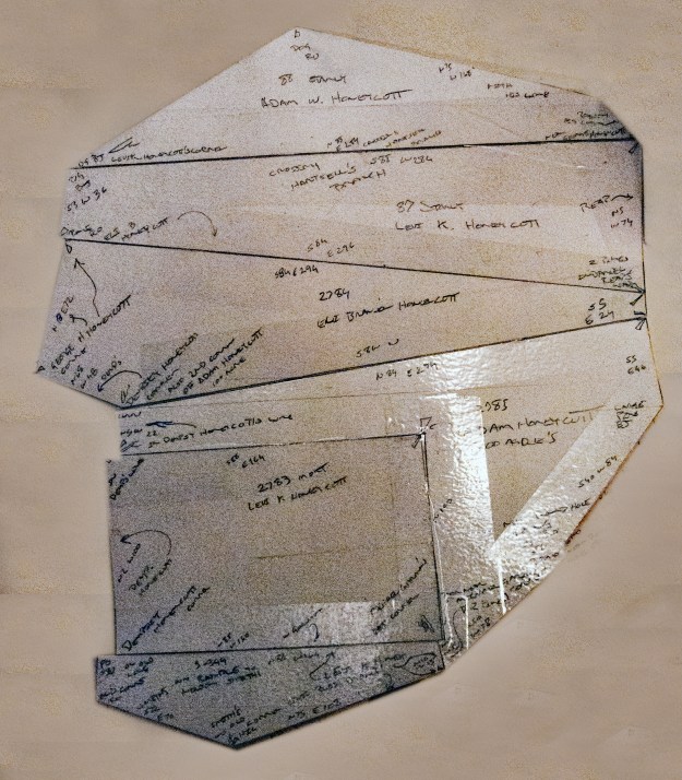
A while back I put together six or so land grants connecting much of the Honeycutt family of Stanly County. Like sticks of firewood stacked upon each other, the nested tracts took on the shape as shown below. It’s a cool shape showing a tight knit family organization…but how do I begin to locate it?
In the 1960’s the USGS began using aircraft to map lands. I guess you could use one plane focusing straight down as it flew. But, there’s a problem with that thinking. Looking at the two images below, the on the left was created using one eye or flight path over a targeted power line. Note the line is not straight as should be. It is deflected by the angle from which the plane sees the line along with both the slope of the hills and creek valleys. The image on the right was created using two opposing flight paths flying parallel to each other. When merged the two separate images negate any deviation. For more on this subject read this article on Rectification by Stereography found on the Penn State Geology Department website.
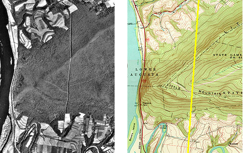
The deformation of the powerline clearing shown in the air photo is caused by relief displacement.
Credit: USGS. “Harrisburg East Quadrangle, Pennsylvania”
So, how do I put this technological application to work in locating the Honeycutt lands? Note that on topographic maps made in the 1960’s you’ll often see red dashed lines here and there on the paper quadrant maps. What are they about? The map makers used these red dashed lines to visually identify long straight lines of trees, cliffs, fields, fences …etc. Such lines offered opportunities to validate accuracy while aligning the maps. A little known gift to those like me who delve into understanding local land records, these dashed lines often echo old metes and property bounds. Just as dirt roads may provide hints as to old property lines, the red dashed lines are often based on field or tree lines following the original courses of early land grants. As for the Honeycutt lands, the above group of tracts is actually findable with only the information provided on the topographic image below. That’s amazing! Can you pick out any of the individual land grant tracts? Note the red arrows point to the red dashed lines. Compare the image below to the one that follows showing Honeycutt land grants plotted and placed.
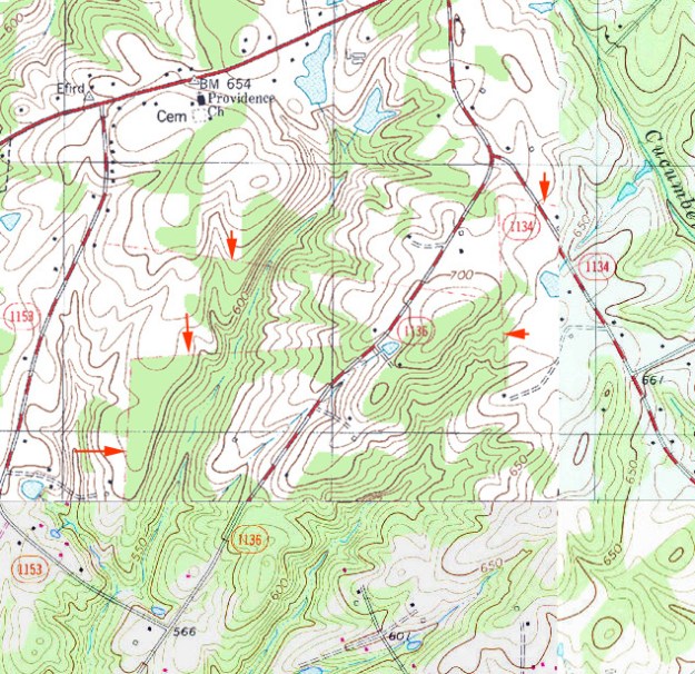
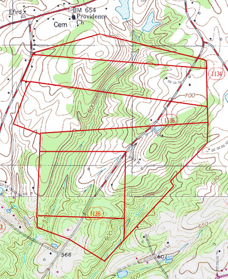
You’ll notice in the above that the bottom quarter of the topographic map image looks a bit different. The image is actually made of two quadrants that I merged together with the northern section being the Locust map and the bottom being the Stanfield quadrant. Note that the Stanfield map doesn’t have any red dashed lines as it’s a 1987 revised map deplete of the old technology dependent upon the red dashed line. Every technological improvement is marked with both gains and losses.
City limits, dirt roads, and red dashed lines are but a few ways maps can be put to work in unravelling the mysteries of land history. The first and most important skill to learn is that of land platting. Once mastered your ideas of when and where can be physically transported to various modes of visual display. As much as any other aspect of family history, the study of maps has opened doors I never knew possible!

Brilliant work on the maps. Love your web site.
Thanks!