Settling in Anson/Union County NC, early land records locate my Thomas family as living in the area of Gourdvine Creek east towards the waters of Cribbs and Pine Log Branches. That’s old news. But, to the west beyond Negrohead Creek (now Salem Creek) lived John Thomas who came to Anson County from Chatham County NC. From DNA we know that John Thomas is not related to our family. We also know John Thomas served in the Revolutionary War and after that moved to Anson County where he lived on Schoolhouse branch of Mill Creek which is close to the old Mecklenburg County line. There’s only one surviving record linking my family to the neighborhood in which this John Thomas lived. And, as it always goes, it’s an important one, opening up possibilities I still don’t fully understand. Let’s take a look.
Dated 11 Oct 1819, Benjamin Thomas and wife Rebecca of Anson sold to Jesse Bryant 200 acres (Deed x-85, Anson NC ) This land was situated on “one side of Retherford (Rutherford/Weatherford Branch) …beginning at James Jenkins corner …to a rock by three red oaks in Pinion’s line.” Witnesses are John Mullis and Edward Vann:
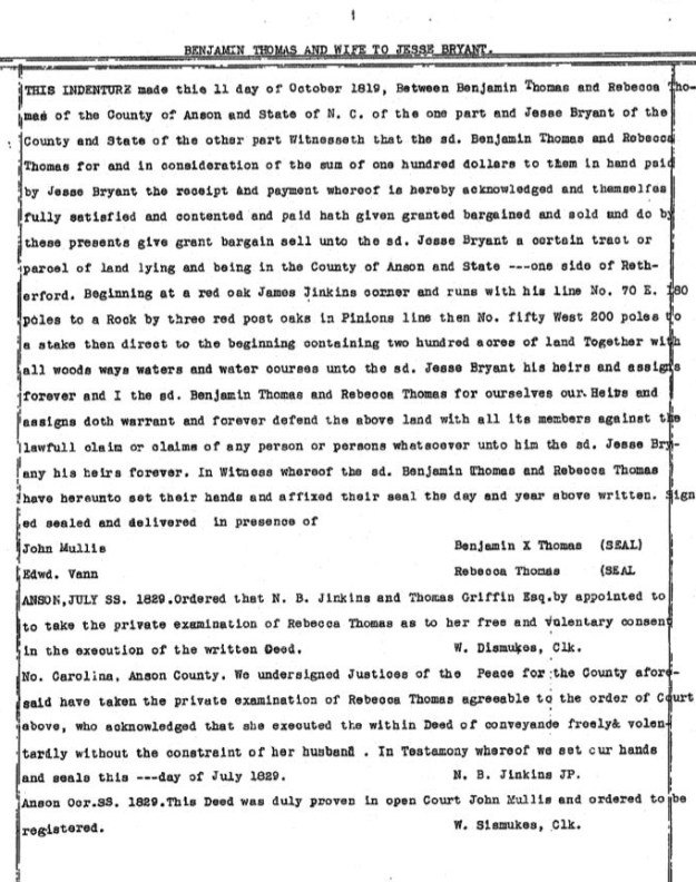
I’ve yet to find a record showing how Benjamin Thomas acquired the above land. Likewise, I’ve found nothing further on how Jesse Bryant disposed of the same. However, years ago I was able to help others confirm that a Jesse Bryant who moved to Pulaski County Georgia is the same person as he who purchased the above land from Benjamin Thomas. And in that find I’ve yet to find anything of importance to our family.
So, …who was Benjamin Thomas? And, who was Rebecca? It’s possible this Benjamin is our patriarch who is believed to have been born in the 1750’s. It’s possible, though no real proof exists, that this Benjamin Thomas died ca. 1833 and is buried in what we know to be the Thomas Cemetery near Charity Ford of Richardson Creek.
It is also possible and even more likely that the above conveyance was made by his son, Benjamin Thomas Junior and a first wife we believe (from this record only) to be named Rebecca. We know for sure that Benjamin Junior owned land just above Charity Ford situated north of Richardson Creek and east of Stegall Branch. It’s also known that Edward Vann earlier from Martin County NC owned land nearby.
Note that in the deed, N. B. Jenkins and Thomas Griffin Esq were “appointed to take the private examination of Rebecca Thomas as to her free and voluntary consent in the execution of the written deed.” Was this dower land or land that had been received through bequeathal? What was Rebecca’s interest? If this is Benjamin Thomas Junior, why or what reason led to his moving beyond the family stomping ground to somehow acquire land just to the west along Weatherford’s Branch? It’s always been a mystery.
____________________________________________
Today I came across another land record connecting my family to Weatherford Branch. And, from past posts you’ll hopefully know that my Great-great grandmother is Allice or Alla Newsom, wife of David Thomas. Alice’s mother is Christian Barnes who likely married Joseph Newsom in Northeast NC. They lived along Gourdvine Creek near the present day Edmond Davis Cemetery. Also living nearby was William Barmes, the brother of my Great-great grandmother Christian Barnes Newsom. William Barnes owned tracts of land scatted along Richardson Creek between Gourdvine and Negrohead (now Salem) branches.
It is said that William Barnes acquired land, salted it with gold and then sold he land at high price before moving to Arkansas. Proof of this has eluded me though deeds at the time of William Barnes’ removal provide fairly strong hints. There must be more and today I stumbled across the record I should have found and seen years ago.
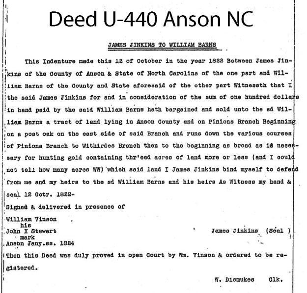
Dated 12 Oct 1822, William Barnes purchased an undefined quantity of land being “as broad as is necessary for hunting gold containing thr’eed acres.” This is pretty cool as the date of 1822 predates much of the hype found in early papers. It may be the earliest mention of gold hunting in the annals of Anson County.
Now, as for the deed, the bounds as seen below ran the “various courses of Pinion’s Branch to Withiride (Weatherford) Branch.”
What really excites me in all of this is the similarities in location of Benjamin Thomas’ deed with that found in William Barnes.’ We now know that in 1822 William Barnes was going out purely for gold on the waters of Weatherford near Pinion and Jenkins. Also, and being 3 years earlier, Benjamin Thomas and wife Rebecca sold 250 acres in the same vicinity. That was the same land or very close to where William Barnes would later hunt gold. And, we know William Barnes’ family married into the family of Benjamin Thomas Junior.
Gold is at the root of many things and here I wonder when its influence swept through the lands along Rocky River. When he sold his land, did Benjamin Thomas have any idea he was sitting on a potential gold mine? We still don’t have the answers though now we have more ideas on what may have been.
