In 1729, Joseph Thomas left his lands on Oropeak Swamp along the North Carolina state line. Per a deed from Samuel Bass [C-213 Bertie, 23 Mar 1729, Mar 1729], Joseph sold two tracts along Oropeak of which one, on a branch known as Elm Swamp, had passed to the said Joseph Thomas by way of a conveyance mentioned in the 1716 last will and testament of Peter Parker. Joseph Thomas then removed to the land he purchased from the said Samuel Bass, being 640 acres on the south side of the Cashie River adjoining the lands of William Williams. And, at the time of his will in 1716, Peter Parker had not only owned land on the state line, he also bequeathed several tracts along Deep Run (now Indian Creek), Wiccacon and White Oak Creeks in present day Bertie County. Legatees in Peter Parker’s last will and testament are sons Thomas, John, Peter and daughters Mary, Ann and Elizabeth.
While trying to get a grip on timing and the sequence of events, I came across Henderson Walker who, as a staunch Anglican became governor of North Carolina (1699 till 1703) following the death of John Harvey. In 1697 Henderson Walker received a grant for 428 acres located on the east side of the Albemarle Sound in what is now Chowan County. This land was likely near Edenton where the governor lived and was buried. Henderson Walker’s grave was later moved from his home to St. Paul’s Episcopal Church cemetery in Edenton. Upon his tomb stone an epitaph is inscribed: “…during (his) administration the Province enjoyed that tranquility which it is to be wished it may never want.” Walker’s widow, the former Ann Lillington, later married the surveyor and mapmaker Edward Moseley whose 1733 New and Correct Map of the Province of North Carolina is so very important to our state history.
From the North Carolina Historical and Genealogical Register [Vol 1, Jan 1900], it is said that Walker’s 428 acre tract was conveyed by Wm. Williams of Isle of Wight Virginia to Peter Parker of Nansemond. Wow …both of these names are players in our story! William William’s father Lewis Williams had been granted 640 acres on the Chowan River May 15, 1697. That tract was conveyed to Peter Parker of Nansemond VA by William Williams of Isle of Wight VA on Oct. 26, 1706. The land had been conveyed to William Williams by John White, Sr.
___________________________________________________
Let’s take a look at Bertie County, the river Cashie and Joseph Thomas’ land situated next to that owned by William Williams. The crude legal description from Samuel Bass’ conveyance reads:
“…assigns forever 200 acres on the south side of Kesia (Cashie) Swamp beginning at a pine in the woods by William Williams plantation then N 5 E 320 poles to a pine standing on Kesiah Swamp then of the meandering of the said branch to the mouth of a great branch then down the various courses of the said branch to a pine in the head line then along the headline to the first station.”
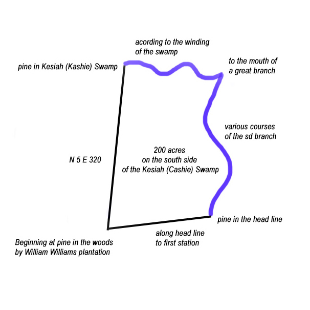
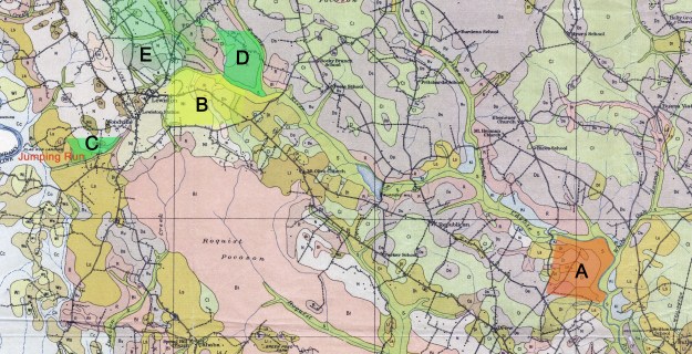
When platted (above), I can only imagine how the “head line” and two waterways actually appeared. There’s simply not enough detail in the description to locate the land. We can’t even properly join the tract to others without lots of guesswork. Seeking to place the tract on today’s topography, the land at first appears to be located near the point where Cashie Swamp forks from the main Cashie river (see orange tract A). And though I’m still not 100% sold on the idea, because it adjoins the lands of William Williams, and from other family and neighboring deeds, I feel this tract may actually be further west near the fork of Cashie and Wattom Swamps (see yellow tract B).
We know because of his last will and testament that the aforementioned Peter Parker died prior to 1716. There’s another person of same name who continues to show up in family records. He’s likely the son of Peter Parker who’s mentioned in the last will and testament of the earlier Peter Parker who died in 1716. In trying to imagine the life of our early family, sometimes you gain more learning about their neighbors. I hope that some of the Parker and other family histories will be helpful in trying to figure out our own.
___________________________________________________
Before getting into specifics based on the few surviving records, it’s important to understand the big picture. With that purpose in mind, know that like Joseph Thomas, Peter and John Parker appear first in Bertie on lands south and west of Cashie Swamp. A person named Francis Parker joins in soon after. Dated 18 Jun 1717, Thomas Parker of Chowan deeded part of his plantation to his loving sons William Parker and Francis Parker. It is believed Francis and John Parker are sons of Thomas Parker who is the son of Peter Parker.
Our Joseph Thomas also owned land nearby with title histories linked to the Parkers. It appears that John Parker had land nearby on the Cashie Swamp but quickly moved a bit further north where he settled along Ahoskie and Wiccacon Creeks. In that area were also the families of Lazarus, Philip, John, and William Thomas who were undoubtedly cousins of Joseph Thomas. Francis Parker seems to have also made the move north before removing to Edgecombe County. It is said by some that Francis Parker married into the Thomas family.
Let’s look at a few deeds in hopes of starting to lock in in on some of the Thomas land locations. Note that the deeds and where I’ve placed them on the map are not meant to be viewed as exact locations. Instead, I just want you to generally know where our family lived. Also note that the deeds below are located on the above map in the (green shaded areas):
[A-36 Bertie, 9 Feb 1722, Feb 1722] Thomas Rhodes and wife Mary to Jeffery Butler, being 100 acres beginning at the fork of a branch on Jumping Run Creek, then out the branch and back to Running Creek and down the said creek to begin. Note that Jumping Run is also called Flag Run and it was so named because the hard bottom was firm enough to allow horses and carts to pass over the swamp. Test: William and Thomas Jones (see green C).
[B-36 Bertie, 6 Aug 1725, Nov 1725] Henry Rhodes and wife Elizabeth to James Blount, being on the North West side of the Casey Swamp beginning at Thomas Busby’s corner on the swamp then down the swap to James Parker’s corner then up his line to Busby’s then down his line to begin. Test: John Duffiel, Thos Benten (see green E).
[B-37 Bertie, Nov 1725] Henry Rhodes to Thomas Busby, being 170 acres on the east side of the Cashie Swamp beginning at the main swamp then a line of marked trees to the side line then to the first station then then to the swamp. Wit: Owen Daniel, James Murray (see green E).
[B-38 Bertie, 9 Nov 1725, Nov 1725 Thomas Rhodes to James Murry, a tract of land in the fork of Kasia Swamp beginning at James Murry corner on the southernmost branch of the swamp where is a beaver dam then up the swamp to a branch that runs by Rhodes’ plantation then up the branch then a row of marked trees to another branch then down a row of marked trees to James Murry’s corner on another branch called Wattom branch then along Murry’s line to the beginning. Wit: Thomas Barfield, Elizabeth Barfield (see green D).
[B-40 Bertie, Nov 1725] Henry Rhodes to Peter Parker, lying on a branch of Cashie Swamp. Running along a line of marked trees between Henry Rhodes and Thomas Busby then down a row of marked trees to the swamp then down the swamp to begin. Wit: James Murry, Thomas Busby (see green E).
Knowing from other records that William Williams’ land is south of the western portion of Cashie Swamp, and if you read between the lines, the above few deeds begin to illustrate the neighbors in an old community situated near the present day town of Woodville. Let’s now start to pick up a few records for Francis Parker:
[A-248/251 Bertie, 10 Feb 1720] Francis Parker carpenter of Bertie to John Parker mill wright of Nansemond VA being 640 acres beginning at gum James Blount and Thomas Busby’s corner then N60E320 to three oaks then S30E320 to a gum then S60W320 to center of 3 hic James Blount’s corner then along his line to begin. This was a lease and return of land from and back to John Parker from Francis Parker. Test. William Horton, Elizabeth E Parker, Francis Parker Junr (see green E).
[B-74 Bertie, 3 Jan 1725, Feb 1725] Richard Melton to Francis Parker being 640 acres is located on the north side of the Morotoc beginning at a gum John Blunt and Thomas Busby’s corner then along John Blont’s corner N60E320 to the center of 3 oaks then N15W 320 to black oak then S48W 266 to a pine Richard Melton’s then with his line and Thomas Busby’s line to begin. Wit: William Cason, Taylor Oquin (top tract below and see green E).
[B-253 Bertie, 7 Mar 1726, Mar 1727] Peter Parker and Henry Rhodes with free consent of both our wives mainly Grace Parker and Eliz’t Rhodes to Dan’l Heismith being 150 acres on a branch of Cashey Swamp called the Broad branch. Beginning at pine of sd branch being a corner tree and running along the dividing line in Henry Rhode’s line then up Rhode’s line then down a line to the afor’sd branch and then down the branch to begin. Wit: Richard Oldner, Lazarus Thomas.
[D-190 Bertie, 12 Feb 1733, May 1735] Francis Parker of now Fishing Creek in Edgecombe County NC to Henry Everand. Being the same land as in Deed D-74 above, the only difference being that the land now adjoins that of John Blount vs James Blount in the prior deed. This 640 acres is located on the north side of the Morotoc beginning at a gum John Blunt and Thomas Busby’s corner then along John Blont’s line N60E320 to the center of 3 oaks then N15W 320 to black oak then S48W 266 to a pine Richard Melton’s then with his line and Thomas Busby’s line to begin. Wit: Thomas Harrill, John Becton (top tract below and see green E).

Following the undated conveyance from Francis Parker to Henry Averett [D-190 Bertie], the next page in the deed book reveals Henry and wife Mary Averett’s conveyance of the very same land to Joseph Thomas [D-191 Bertie, 12 May 1735, Rec. May 1735, Wit: John Harrill, Jos. Harrill]. So this tract of land eventually owned by Joseph Thomas had passed from Richard Melton to Francis Parker and then from the said Parker to Henry Averett who in turn deeded it to Joseph Thomas.
Note in the above that the initial conveyance from Francis Parker to Henry Averett was not dated. It was recorded however at the same time in May 1735 when Henry Averett sold the same land to Joseph Thomas. As Joseph Thomas’ last will and testament was probated earlier in Feb 1735, we know that Joseph was dead at the time when Henry Averett deeded the 220 acres. Whew …it’s possible Joseph had never recorded the conveyance and this was simply a means of recording the conveyance post mortem as part of the estate settlement. It’s also possible that the conveyance from Henry Everett refers to Joseph Thomas’s son of same name. If so, it signals that the younger Joseph Thomas was of legal age in 1735. In his last will and testament, Joseph Thomas (the elder) writes:
Item I give and bequeath to my well beloved wife Eales Thomas my plantation that I now live upon at her own disposal during her life and likewise all my stock and ___________
Item I give and bequeath to my son Joseph Tomas the above mentioned plantation after my wife’s decease and the privileges of ____ part of it in her lifetime provided he does not __________ her upon any_____________.
If the land was to pass as directed in the will, we know it certainly did not play out as the will suggests as from later records we know that Joseph’s wife lived beyond both the will and above deed dates.
So far I’ve only been able to connect one other piece of land to the tract Joseph Thomas purchased of Henry Avertt. The top tract of the two drawn above represents the 640 acres leased between John and Francis Parker. That piece of land abuts the tract deeded to Joseph Thomas by Henry Everett. The line of importance is the starting line that begins with a gum and runs N60E320 to three red oaks. In later posts we’ll look at this tract in hopes of determining what happened to it following the 1730’s death of Joseph Thomas. Also, and in looking at all the records I’ve presented in this post, please notice how the names Blount, Parker, Averett, Busby and others are mentioned quite often. Take time to google these names so you’ll know more about your ancestor’s neighbors. I think it really was a tight community.
___________________________________________________
At this point we’ll rest with the idea that Joseph Thomas lived on land along the western extent of Cashie Swamp near present day Woodville in Bertie County. Following the conclusion of the Tuscarora War, this was a time when the Indian villages to the south were well established. It’s also a time that we now sadly know to be the beginning of their end. I have to wonder how all that played out while my family was settling just to the north on lands adjoining James Blount/Blunt. Was this the same James Blunt who became chief of the Tuscarora following the death of King Tom Blunt?
On 1 Mar 1711 John Dickson sold to Thomas Hart 300 acres [C-241 Chowan] joining Richard Melton. The land was called “by the name of the Village.” Knowing that Joseph’s land passed to him from Richard Melton, you can see in this deed how close Joseph must have lived to the indigenous people.
In the next post I’ll start to look at Joseph Thomas’ family and later conveyances that undeniably link Joseph to his children and wife Alice.

George, I met you this morning at Archives. I just read your entry on Bertie and the Cashie. Please email me directly. I know the area where some of the deeds you are mapping are located. Gregory
George, I enjoyed reading your deeds and could you help me there is a deed in colonial Bertie County nc Book F 212 My line goes back to this Abraham Page who witness this deed is this land close to Thomas Busby land Thanks for any help
Have you considered here that the Blunts/Blounts are the same as those who were leading the Tuscarora?
Yes indeed, but thought it not based on chain of deeds between Thomas and James Blount. Thought this to be the family who King BLunt derived his name.
I haven’t managed to find many of these families, Busby, Melton, Blunt, Herring, in the later tax lists, even from the 1750s. I wonder, did they move away?
Not sure. I remember tracing this group and witnesses etc of deeds mainly in hopes of finding later clues of what happened to the land and mostly, where it was. Where was the the fork between the swamp and the big branch? Was that north of chesky, being the branch of the swamp off of the river? Or, was it further west, maybe south of Woodville on a major branch north of Indian Branch? That was the nature of what I was looking for to determine where they lived and whether or not I was misconstruing records meant for different families, which is possible.
Okay. My grandmother’s kit has a small amount of Native American on it, about 2-3 percent. When I try to trace those segments, and look at who matches on them, and their trees, I often encounter these names, Busby, Melton, Herring, Pierce, Bird/Byrd, and Williams. I have Williams in my tree. I wonder if this neighborhood is the source of some of that ancestry.
I think mixing was more widely spread and somewhat normalized though still likely involving abuses going back to the days when NA were enslaved before Africans. I know Arthur Williams’ wife was Mulatto. Wasn’t he a son of William? I’d love to see on one document all those who records show being mixed along with a brief on the proving record.
It’s very complicated. Instead I just see trees that terminate with Busby, Whitmell, Harrington, Melton, Vann, etc. These were traders. And we are also dealing with a timeframe of about four hundred years ago now. I am trying to figure out how my ancestor Samuel Williams, who left a will in Gates County in 1789, fits into the Williams family. He had a son named Arthur, and there was also a Whitmell Williams in Gates. It seems to be the same family. There were A LOT of mulatto families in colonial tax lists that suddenly became white just in time for the 1790 census.
I meant the trees of matches who match on segments painted as Amerindian.
Pingback: the Tuscarora Town | Andersons of Colonial N. Carolina