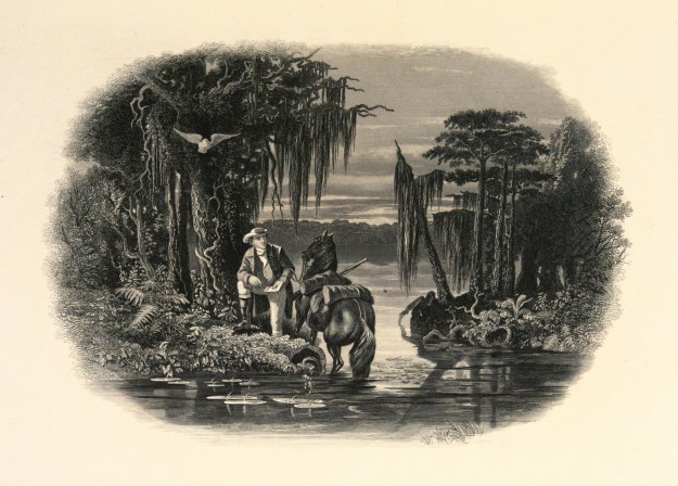
George Washington at Lake Drummond
 It was just three years before Joseph Thomas was awarded his headright on Orapeake Swamp when John Lawson was captured and killed by Tuscarora Indians while on an expedition with Christoph von Graffenried. The two were seeking the source of the Neuse River. John Lawson had journeyed across the back country where by 1709 he wrote his fabulous book titled A New Voyage to Carolina which detailed all that he saw and encountered. And then, in 1710, John Lawson and Edward Mosley were named to a commission tasked with surveying the state line between North Carolina and Virginia. Unable to reach consensus, that effort failed.
Joseph Thomas received his headright in 1714 Virginia though the land was situated near the line in what’s now North Carolina. The state line was simply unknown.
_____________________________________________
 Another timely event. Can you imagine life on the farm when all of a sudden a group of men stepped out of the swamp with axes, chains and lots of talk of cutting the state line through or near your land? That actually happened in 1728 when William Byrd II led another attempt to survey the state line. From William Byrd’s diary we get a glimpse of early life on the Oropeake Swamp:
In these sad circumstances, the kindest thing we could do for our suffering friends was to give them a place in the Litany. Our chaplain, for his part, did his office, and rubbed us up with a seasonable sermon. This was quite a new thing to our brethren of North Carolina, who live in a climate where no clergyman can breathe, any more than spiders in Ireland.
One thing may be said for the inhabitants of that province, that they are not troubled with any religious fumes, and have the least superstition of any people living. They do not know Sunday from any other day, any more than Robinson Crusoe did, which would give them a great advantage were they given to be industrious. But they keep so many sabbaths every week, that their disregard of the seventh day has no manner of cruelty in it, either to servants or cattle. It was with some difficulty we could make our people quit the good cheer they met with at this house, so it was late before we took our departure; but to make us amends, our landlord was so good as to conduct us ten miles on our way, as far as the Cypress swamp, which drains itself into the Dismal. Eight miles beyond that we forded the waters of the Coropeak, which tend the same way as do many others on that side. In six miles more we reached the plantation of Mr. Thomas Spight, a grandee of North Carolina. We found the good man upon his crutches, being crippled with the gout in both his knees. Here we flattered ourselves we should by this time meet with good tidings of the surveyors, but had reckoned, alas! without our host: on the contrary, we were told the Dismal was at least thirty miles wide in that place. However, as nobody could say this on his own knowledge, we ordered guns to be fired and a drum to be beaten, but received no answer, unless it was from that prating nymph Echo, who, like a loquacious wife, will always have the last word, and sometimes return three for one. It was indeed no wonder our signal was not heard at that time, by the people in the Dismal, because, in truth, they had not then penetrated one third of their way. They had that morning fallen to work with great vigour; and, finding the ground better than ordinary, drove on the line two miles and thirty-eight poles. This was reckoned an Herculean day’s work, and yet they would not have stopped there, had not an impenetrable cedar thicket checked their industry. Our landlord had seated himself on the borders of this Dismal, for the advantage of the green food his cattle find there all winter, and for the rooting that supports his hogs. This, I own, is some convenience to his purse, for which his whole family pay dear in their persons, for they are devoured by mosquitoes all the summer, and have agues every spring and fall, which corrupt all the juices of their bodies, give them a cadaverous complexion, and besides a lazy, creeping habit, which they never get rid of.
…Care was taken to erect a post in every road that our line ran through, with Virginia carved on the north side of it, and Carolina on the south, that the bounds might everywhere appear. In the evening the surveyors took up their quarters at the house of one Mr. Parker, who, by the advantage of a better spot of land than ordinary, and a more industrious wife, lives comfortably, and has a very neat plantation.
…The line cut William Spight’s plantation in two, leaving little more than his dwelling house and orchard in Virginia. Sundry other plantations were split in the same unlucky manner, which made the owners accountable to both governments. Wherever we passed we constantly found the borderers laid it to heart if their land was taken into Virginia: they chose much rather to belong to Carolina, where they pay no tribute, either to God or to Cæsar.
Worries were much more sinister than the mere concerns over running the state line. A fox was surely loose in the hen house …you’d better keep an eye on that fellow lest your wife or children be “rogered.” (Note to self: look for DNA matches to William Byrd II).
_____________________________________________
Joseph Thomas sold his land near the Dismal Swamp less than a year after the survey. William Byrd had referred to the area as “a miserable morass where nothing can inhabit.” Removing to Bertie County, I can only imagine what drove Joseph Thomas away from the neighborhood. Looking creatively at a bad situation, Byrd had even proposed using slave labor to drain the swamp with a network of ditches and canals. But, there were problems with this idea as the Great Dismal Swamp sits on high ground. Instead of being a low place like most swamps, it is a source of water flowing outward away from the swamp …not a place where water naturally wants to pond.
Nearly 30 years after Joseph Thomas left the area, big money, politics and a bold scheme built upon the vision of William Byrd. In 1763, George Washington visited the Dismal Swamp and surrounding areas including Oropeak Swamp. From his diary, George Washington wrote:
Between Cyprus Swamp, and the last mentioned one, we went on horseback not less than ½ mile into the great swamp (Dismal) without any sort of difficulty, the horse not sinking over the fetlocks. The first quarter, however, avounding in pine and gallberry bushes, the soil being much intermixed with sand, but afterwards it grew blacker and richer with many young reeds and few pines, -and this, it may be observed here, is the nature of the swamp in general.
From Mossey Swamp to a branch, and a large one it is, of OROPEAK (Not less than 80 yards over) is reckoned 4 miles; two miles short of which is a large plantation belonging to one Brindle, near to which )on the south side) passes the Carolina line.
The Main Swamp of OROPEAK is about 1.2 mile onwards from this, where stands the Widow Norflets, Mi & Luke Sumner’s plantations. This swamp cannot be less than 200 yards across, but does not nevertheless discharge as much water as Cyprus Swamp.
At the mouth of this swamp is a very large meadow of 2 or 3000 acres, held by Sumner, Widow Norflet, Marmaduke Norflet, Powel and others, and valuable ground it is.
From OROPEAK Swamp to Loosing Swamp is about 2 miles, and this 70 yards across.
From hence again to Bassey Swamp the lower road may be allowed 2 miles more, but this swamp seems trifling.
And from Bassey Swamp to Horse Pool (which is he last, and including swamp running into the Dismal) is about 2 miles more and 35 yards across only.
The whole land from Pocosom Swamp to this place and indeed all the way to Pequemin Bridge, is a manner a dead level, wet and cold in some place sandy in others, and generally poor.
Looking back at Joseph Thomas’ land, what happened to it after he left for Bertie. And, is there any connection at all to Washington’s visit? Let’s take a quick look at two deeds:
• Deed Book W1, 375-376 Chowan, 10 Feb 1737. Lemuel (LB) Bass to Edwd. Skeeter being two tracts, one of 175 acres and one of 14 acres. Witness John Sumner, Henry Hunter, Wm Speight.
• Deed Book G1-5-8, Chowan, 16 Jan 1753. Edward (ES) Skeetor to Edward Arnell for 175 acres on the southwest side of the Oropeak swamp joining Edward Arnell, Thomas Hinton, Patrick Woods, and Batttles being the land purchased of Joseph Thomas to whom the sd lands was granted by Alexander Spotwood late Gov of VA. Also another tract of 14 acres. Wit: Demsey Sumner, Elisha Parker.
• Headright, 25 April 1701, Nansemond VA. Edward Arnold, being 89 acres on the South westward side of Oropeak swamp beg. on the S.W side ye aforesd. Oropeake swamp near Battles corner tree.
• Headright, 28 Oct 1702, Nansemond VA. Richard Sumner, being 330 acs. in Upper Par., Nansemond Co., on the northwest side of the Mossy Sw., beg in the 2nd branch of Oropeak in the Round Trees Line; along the Desert; on the Brinkley’s Land.
From my last post, Joseph Thomas acquired a small 14 acre tract in the fork of Oropeak and Elm Swamps. John Battles owned land to the west of the tract followed by Joseph Thomas’s 175 acres to the west of said John Battles. Samuel Bass [Basse] purchased Joseph Thomas’ land and then sold it to Edward Skeetor in 1737. Witness to that deed was Wm. Speight whose land was cut into per the diary of Wm Byrd II. In 1763, George Washington mentions Bassey Swamp …could this be named for the Bass family?
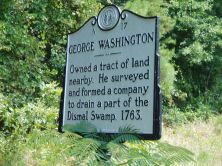 Other names also appearing in the above records include members of the Sumner family. In 1763, Fielding Lewis, George Washington’s brother in law, purchased nearly 40,000 acres total with over 1,000 being from the Sumner family. Forming the Dismal Swamp Company, Washington, Byrd. and others worked to reroute the swamp’s source of water. Efforts expanded to included canals connecting Virginia and North Carolina wateways. But by the late 1700’s, George Washington became frustrated with the project and sought to sell out his share. Henry (Light Horse) Lee, the father of General Robert E. Lee, was approached but did not have the funding necessary to secure the transaction.
There are old maps of the project and today the area is known as Corapeake. There is a State of North Carolina Historical Marker south of the town of Corapeake marking Washington’s visit and purchase. Today Coropeak and the Great Dismal Swamp are crisscrossed with ditches and canals began during the times of our early 1700’s ancestors. The greatest of the canals , the Dismal Swamp Canal, is a great recreational spot and is worth visiting.
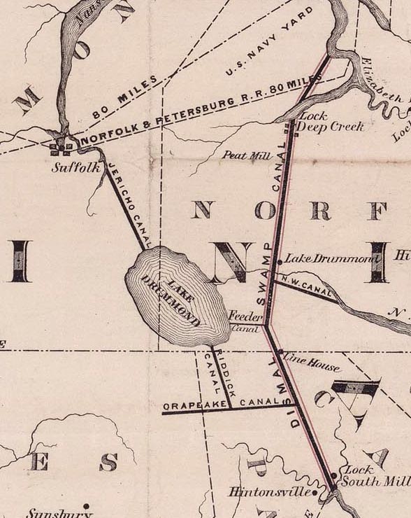
Map of Dismal Swamp Canal drawn by D. S. Walton – 1867
