
Dated 16 Jun 1714, Joseph Thomas received a headright for N.L. (new land) located in the Upper Parish of Nansemond County Virginia. Situated on the south side of the Orapeake Swamp, the land adjoined that owned by Edward Arnold, Thomas Milner, Patrick Wood and a Mr. Battle. Joseph Thomas received the 175 acres as reward for importing from England the following 4 persons: Joseph Thompson, Elizabeth Thompson, Michael Thomas & his wife (Cavaliers and Pioneers Vol 3 –page 140, by Nugent).
The headright for Joseph Thomas raises several questions that I’ve never clearly seen answered. First, was the name “Thompson” used in the grant a mistake and did it instead refer to the family of “Joseph Thomas” who actually received the land grant? And second, it is believed that Joseph Thomas was born in Virginia from a long line of Thomas family going back to the early 1600’s. In lieu of this record, can that be so and does this record imply that Joseph Thomas also made a trip from England? And, exactly how does the named Michael Thomas and wife play into our family story?
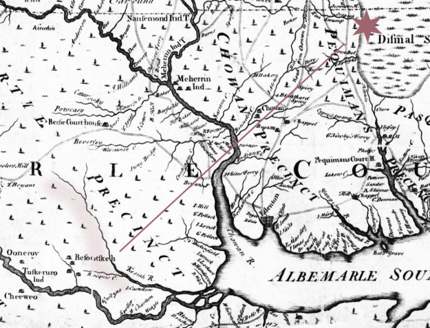
Though granted by the State of Virginia, this land belonging to Joseph Thomas may actually be located on the Oropeak Swamp near the state line in present day Gates County, North Carolina …not Virginia. Later conveyances of the granted tract indicate the land must also be close to the Elm Swamp. From Edward Mosley’s 1733 New and Correct Map of the Province of North Carolina, both the Orapeak and its southern branch, Elm Swamp, are seen as sources to the Great Dismal Swamp lying to the east:

To the west of the above, early Chowan Precinct became Chowan County when in 1720 Edenton was designated as the county seat. And from early Perquimans Precinct (taking up most of this map), the county of Perquimans was officially formed in 1739. It wasn’t until 1779 until Gates County was created in honor of Horatio Gates who would later lead the Maryland Continental line at the failed battle of Camden. The earliest known lands of Joseph Thomas are located near the Virginia state line in present day Gates County. Any ownership in Virginia is yet proven.
Within two years of acquiring his land on Oropeak Swamp, Joseph Thomas is mentioned in the 5 Sep 1716 last will and testament of Peter Parker. Among bequeaths including land on Deep Run and Wishacone Creek, Peter also orders “Joseph Thomas to pay 1200 pds of tobacco for my land at Elm Swamp”. Looking at the above map, you’ll see the name “Parker” located in the upper left corner not far from Orapeak Swamp.
________________________________________
Dated 23 Mar 1729, Joseph Thomas sold his land to Samuel Bass. Recorded in Bertie County, the deed identifies both the buyer and seller as farmers “both of the Govern of North Carolina” …no mention of county. The first tract below is certainly Joseph Thomas’ original headright. The metes and bounds along with Peter Parker’s last will and testament can be used to identify the second smaller tract as lying in the fork of Oropeak and Elm Swamps (located on the map above):
• First Tract being 175 acres on the southwest side of Oropeak Swamp – beginning at a maple a corner tree of Edward Arnold’s land standing by the swamp and runs thence along the said Arnold’s line south westerly 14d 119p to a white oak thence south westerly 52d 139p to a pine, thence south westerly 12d 75 ½ p to a pine in Thomas Milner’s line, thence on sd Milner’s line south westerly 35d 38 p tp a pine thence north westerly 60__163 p to a pine, then north easterly 27d 68 ½ o to a gum in Patrick Wood’s line thence on Wood’s north easterly 71 ½ p to red oak thence northeasterly 7d –54p to a pine in Battle’s line, thence north easterly 58d on sd line 201 p to the first station.
• Second Tract being 14 acres which sd Thomas purchased of Elizabeth Parker & John Parker her son – known as “Little Neck” beginning at a marked gum on the side of Orapeak swamp in the mouth of a small branch thence running up the sd branch along a line of marked trees to a poplar, it being a line tree of John Battle’s, thence running down the said line to a marked white oak standing on the west side of the Orapeak Swamp, it being a corner tree of the said John Battles, thence running up the swamp to the first station.
The deed from Joseph Thomas to Samuel Bass was witnessed by John Perry and Anderson Sugg and was registered much later on 2 May 1755. What happened in 1755 to warrant a need to record the deed at that time? Joseph Thomas Senior [I] died around 1732 and we know his son Joseph Thomas [II] dies sometime between 1752 and 1755. Maybe there was a need to record and clear the title prior to the settlement of estate for Joseph Thomas [II]. Of importance, Joseph Thomas [I] signed the above deed with a mark that appears in form to be a capitol I with mark through the middle. The original does not exist and this deed book copy was surely from a later transcription as it’s written on lined paper. Even so, Joseph Thomas who left his last will and testament in 1732 Bertie County signed with a similar mark.
 Beyond the comparison of signature marks, there’s one other bit of evidence that links Joseph Thomas of Oropeak with Joseph Thomas who died ca. 1732-5 in Bertie. On the very same date as the sale from Joseph Thomas to Samuel Bass, Samuel Bass returned the favor by selling a tract of 200 acres to Joseph Thomas. Lying on the south side of the Kashie Swamp, metes and bounds for that transaction reads:
..beginning at a pine in the woods by William Williams plantation then n5de 320p standing in the Kesia Swamp, then according to the meandering of the swamp to the mouth of a great branch, then the various courses of the said branch to a pine in the head line, then along the head line to the first station.
Witnesses were again Anderson Sugg and Jno Perry.
In summary, Joseph Thomas received a Virginia headright in 1714 on land in present day North Carolina. Joseph sold the land in 1729 to Samuel Bass who in turn sold Joseph a tract in Bertie where Joseph wrote a last will and testament in 1732. The land on Oropeak Swamp was situated in an area rich in American history. In the next post I’ll look at later conveyances and of business ventures among the rich and famous.

I have a copy of a deed from 1803 and a copy of the previous deed to same land in May year 17 something. Could be for same land you referenced. Let me know if you are interested
Yes, I’d love to see a copy of what you have. If not our land maybe learning its details would be helpful to someone else.
My wife’s family settled in Hertford in 1658. There is some information of the area from George Foxe’s ride through present day Gates County in 1675.
Indeed, I believe our beginnings were far more involved than what usually appears on the cleansed online genealogies. Writing about the communities in which folk once lived, the role of People of Color, whether indigenous or rooted in Africa, played an often-untold role in who we have become today.