…it is mortifying to witness the fact that thousands of our wealthy and respectable citizens are annually moving to the west in quest of that wealth which a rich soil and a commodious navigation never fail to create in a free state; and that thousands of our poorer citizens follow them.”
In 1819, Archibald Debow Murphey, an educator and Orange County Senator, included the foregoing observation in his report on the immediate need for state-funded infrastructure. This may be the only period thoughts I’ve seen expressed on the realities of migration, both within and out of our state, and I believe the statement fits perfectly with my personal beliefs. No way would a poor or working farmer strike out on his own without a cause and means. And for my salt-of-the-earth ancestry from Down East, I’ve always wondered about motivation and exactly what drove them west. Where did they get the idea to move, and who supported them? Who was it that might have said, “Hey, Joshua Burris, you need to leave your perfectly good home in Bertie County and make a new life beyond the Yadkin”? Maybe life wasn’t perfect, but yes, Joshua did move, and he did patent land on Jones Creek in 1778 in Anson County. Was he alone in the new place? Was the move truly his idea, or, as Senator Murphey intimates, was he wealthy, or maybe one of thousands of our poorer citizens who followed?” Let’s look closer.
In 1748, a year before Anson County was even formed, George Gould received two patents for land mistakenly described at the time as lying on the east side of the Pee Dee River. One tract was on Mountain Creek and the other on Jones Creek. Neither the two surveys nor any of the loose papers survive. Housed at the State Archives of North Carolina and accessed through nclandgrants.com, the patent book entry documenting issuance of George’s 640 acres is shown below.
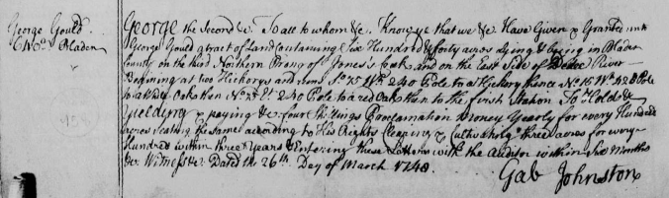
George Gould died prior to the fall of 1763, as at that time, Elizabeth Gould, his widow “of Bertie County,” deeded the foregoing property to John Campbell, merchant. John Campbell was also from Bertie County, and concerning the 640 acres, it was called out as “lying & being in the County of Anson on the third northern prong or fork of Jones Creek of the East Side of the Pee Dee River.” Elizabeth was authorized to deed the land as “sole Executrix representing the heirs of her late husband George Gould deceased, by his last will and testament duly proved and administered according to law of the one part and John Campbell, of the county and province aforesaid Merchant of the other.” Housed at State Archives of North Carolina and accessed through FamilySearch, the will was penned on 8 Jul 1749, and reads in part:
Item: to my Godson William Coopland a thousand acres of land in Bladen County on Browns Creek.
Item: to my Goddaughter Susana Astie [Hastie, Hastey?] a thousand acres of land in Bladen County on Brown’s Creek.
Item: in the case of the death of my Godchildren William Coopland and Susana before they come of age, then the land is to revert to my loving wife and Executrix …Elizabeth.
Executors: Thomas Barker, Benjamin Hill.
I believe William Copeland is the same person who penned a last will and testament in 1789 in Chatham County, and is it possible that Susana, the daughter of John Astie, is a member of the Hastey family who also came to Anson County? John Astie is seen acquiring land in 1748 in Edgecombe County, so we know the family was moving west when John died prior to George Gould in 1749. Who was George Gould?
It seems either the accepted historical timeline is tangled or I have it wrong; however, George Gould was a hugely powerful and significant figure in early North Carolina. And yet, the Bertie County Heritage book mentions nothing of George Gould while dedicating tons of printed space to the landmark called Mount Gould, likely named for George Gould. Note that my writing is researched and written in haste, and I would like to hear the thoughts from local voices …but for now, let’s move forward.
George Gould acquired a place called Mount Galland from William Maule, whose place name was changed to Mount Gould. From the Rootsweb site pertaining to Historic Homes of Bertie County:
Mount Gould was originally called MT. GALLAND. William Maule named it in honor of his wife, PENELOPE GALLAND, step-daughter of Gov. CHARLES EDEN. It was probably built in the late 1700’s and added to at a later date in the 1800s. The old still-standing [building] was built in 1800 by George GOULD, at one time surveyor general of the Colony.
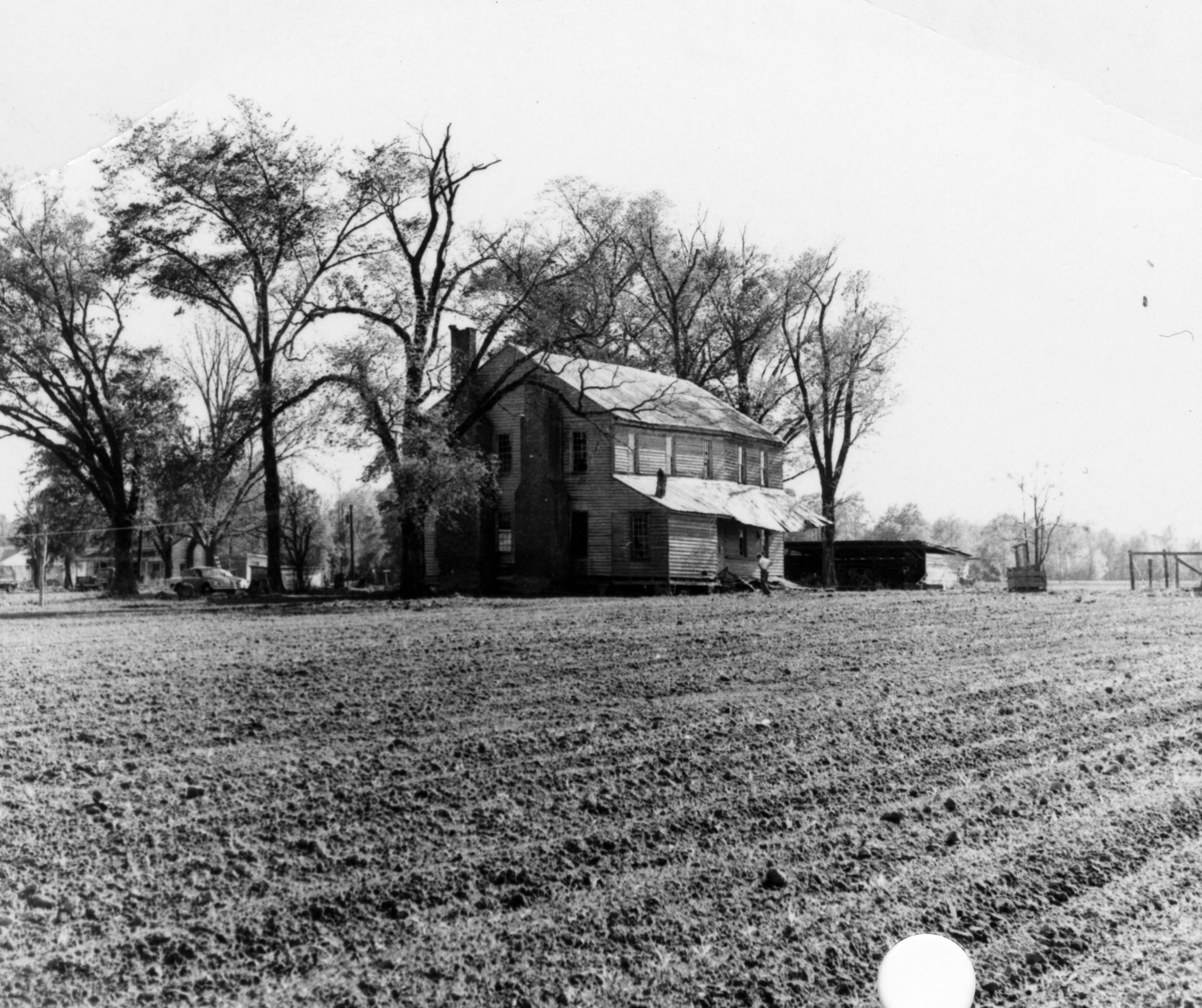
George Gould, who died in 1749, was identified in the Anson County deed as a merchant. More importantly, he was the colony’s surveyor general and is noted for numerous accomplishments, including early surveys of the Tuscarora lands. I cannot see how he could have built the house at Mount Gould in 1800 since he wrote his will in the late 1740s. Albeit, from lore, the structure he lived in surely existed in that spot. Much is written about the place that sits on the western rise above the Chowan River and east of The Eastern Most Creek, and yes, that is the name of a creek. The following photograph of Mt. Gould was accessed online from the holdings of the NC State University digital library:
 George Gould acquired his land from William Maule, who married Penelope Golland, the stepdaughter of Governor Charles Eden. A hugely important man, William Maule preceded George Gould as surveyor general and is the person who surveyed Roanoke Island in 1718. Following his death in 1726, William’s widow married Governor Gabriel Johnston. Edward Mosely replaced William Maule as surveyor general and produced the 1733 New and Correct Map of North Carolina. William Maule owned numerous plantations across Bertie County, but, significant to this writing, he acquired lands from the mouth of the Wiccacon River south, along the western banks of the Chowan River.
These are indeed the sorts of people Archibald Debow Murphey had in mind to provide leadership and impetus for the westward movement of people. But what happened to George Gould’s land on Brown Creek? Elizabeth Gould sold her husband’s Anson County estate land to John Campbell. Then, in 1775, John Campbell, a merchant of Bertie County, sold it to Burwell Lanier. At that point, the 1000 acres were called out as lying on Brown Creek, on a fork called Gold’s Fork. Hmm, there you have it, though now a new person is introduced. Exactly who was John Campbell, and how did he play in the picture?
I’ve already written about John Campbell, but to recap, he was William Maule’s neighbor to the north and likely acquired land once belonging to William. John Campbell was the province’s most significant merchant, and in 1739, his ship was identified in English records as follows:
Nov-Feb 1739/40 London – Embargo placed on Mary and Mariane by British Public Records Office.
27 th of Feb 1739/40 an Order of Council and Warr for “discharging from the Embargo the Snow Mary and Mariane John Campbell Burthen 100 tons or thereabouts Navigated with five men now in the River of Thames bound for North Carolina loaden with Sundry Merchandise in a perishing condition, and having on board 50 poor foreign protestants and Servts whom he has maintained on board ever since 23rd Dec last.” [PRO, 1734-1740]
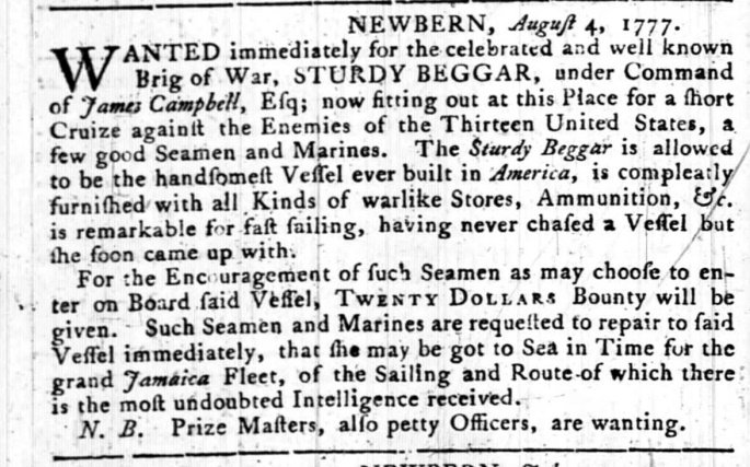
I see this and wonder: did we migrate to the colonies through Virginia, or should we consider the chances of coming to the Carolina shores by boat? One named the Mary and Marianne? And if that’s not enough to illustrate the strength of this one family, John Campbell’s son named James upfitted a boat “now sitting out at this place for a short cruise against the enemies of the Thirteen United States,” wow!
Again, these are important people, but bigger fish remain to be fried. However, and crediting the foregoing to the wonderfully researched histories on Sally’s Family Place, again, a happenstance query on my computer’s Copilot Search provided the following in-depth report:

Order of Council and Warrant for Discharging the Snow Mary and Mariane (1739/40)
On 27 February 1739/40, an Order of Council and a warrant were issued to discharge the Snow Mary and Mariane from the British naval embargo. These vessels, commanded by John Campbell Burthen, were 100 tons or thereabouts and had been navigating with only five crew members【PRO, 1734–1740】.
Vessel and Crew Details
- Name: Snow Mary and Mariane
- Master: John Campbell Burthen
- Tonnage: ~100 tons
- Crew: 5 men
- Route: Bound from the River Thames to North Carolina
- Cargo: “Sundry merchandise” in a perishing condition (likely deteriorating due to poor storage or weather)【PRO, 1734–1740】.
Passengers
On board were 50 poor foreign Protestants and servants. Burthen had maintained them on board since 23 December of the previous year (i.e., from late 1738), indicating a long-term voyage and possible humanitarian or religious mission【PRO, 1734–1740】.
Context
The naval embargo referenced here likely relates to the War of the Austrian Succession (1740–1748), during which Britain imposed restrictions on certain trade routes and vessels. The Order of Council and warrant would have been legal instruments authorizing the release of these ships from embargo, permitting them to proceed to their destination despite restrictions.
Significance
- The case reflects the intersection of naval law, trade policy, and humanitarian concerns in the early 18th century.
- The presence of 50 passengers, many of whom were foreign Protestants, suggests a possible religious or charitable mission to North Carolina, a region with growing colonial settlements and religious diversity.
- The “perishing condition” of the cargo indicates logistical and maritime challenges in long-distance colonial trade.
This record is preserved in the PRO (Public Record Office) series 1734–1740, which contains administrative and legal documents from that period.
Moving forward, in my book, Finding Big Lick, I write extensively about the coming of people during a time of yet-to-be-secured government in a setting of land schemes most notably known as the Great Tracts. Another concern dates to a much earlier time. In 1663, Sir George Carteret was appointed Lord Proprietor of Carolina, but after his death in 1680, his son and heir, John Carteret – 2nd Earl Granville, disagreed with the other proprietors who sought to return the colonial proprietorships to the crown. Instead, after 1729, John worked out an agreement giving him full ownership of a 60-mile swath from Virginia south to a line called Granville, which so happens to run east-west between today’s Rowan and Stanly Counties. The line was first run in the mid-1740’s under Gabriel Johnston, who earlier married William Maule‘s widow in 1733. It’s a small world.
As it so happens, another scheme or land grab was underway. In 1737, London merchants James Huey and Murray Crymble proposed a lucrative plan to settle the North Carolina backcountry. The business partners petitioned the Crown for 1,200,000 acres to be settled by six thousand Protestants:
“…praying for a Grant of Lands upon the heads of the Peedee, Cape Fear, and Neus Rivers in North Carolina, and proposing to make a Settlement thereon of six thousand Swiss Palatines and other Foreign Protestants within the space of Ten years from the Date of Grant…”
However, acting as a silent proxy for London merchant Henry McCulloch, the deal served another purpose: to allow the ambitious McCulloch to manage the land as he pleased. McCulloh was appointed “commissioner for supervising, inspecting, and comptrolling our revenues and grants of land in South and North Carolina,” and is said to have used his authority against Governor Johnston. McCulloh lost his claims but regained status only after Johnston’s death and the rise of land speculating Governor Arthur Dobbs.
In 1757, Henry McCulloh late of Soracte in the Province of North Carolina but now of Turnham Green in the [County] of Middlesex England Esqr., appointed power of attorney to “John Campbell Esqr Merchant in Bertie County in the Province of No. Carolina and [son] Alexander McCulloh Esqr Deputy Auditor of the same Province.” At issue against Granville land agent Francis Corbin were Henry McCulloh’s 1,200,000 acres and whether Lord Granville’s tract trespassed. Henry McCulloh lost the battle and much of his holdings in the northern half of the colony.
And then, Henry McCulloh, of the County of Middlesex, England [appointed power of attorney] to John Campbell and Henry Eustace McCulloch, his son, which is witnessed by the affidavit of David Meade as follows: “I, Henry McCulloch, late of Sarecta, in the Province of North Carolina in America, but now of the Parish of Cheswick in the County of Middlesex and the Kingdom of Great Britain:
Whereas, on December 13, 1736, and on May 22, 1740, I received grants to 1,200,000 acres of land in the said province of North Carolina; and, I am entitled to eight grants, each of them containing 12,500 acres of land, lying on the branches of the PEEDEE and WHOREE Rivers in North Carolina, made out in the name of Dr. William Houston; also eight other grants of 12,500 acres each on flat END and TAR Rivers in North Carolina, and various other grants, this power of attorney is given to John Campbell and my son Hery Esustace McCulloch this the __day of__, 1761.”
The aging father utilized his sons with Henry Eustace taking an active role as agent when he came to North Carolina in the early 1760s. And concerning John Campbell, he was of such power to represent the family in what was surely the greatest land venture in our state’s history. And yes, John Campbell did gain access to land in Anson County about the same time as our Joshua Burris moved west. But how well did the two know each other? Joshua Burris was certainly not the wealthy driving force in this crowd and sequence of events, but now we know who that force might be. Not only did John Campbell and George Gould have land involvement in Anson County, but John’s son James also moved west to Orange, where he settled after the war.
It is a small world, and back in Bertie County, Joshua Sen’r and his father, James Burris, leave us with records pointing to John Campbell, William Maule, and others who lived in the middle-east of Bertie County. They certainly knew of each other, as Joshua Burris was named in a civil action brought to court by John Campbell. Joshua owned land near the river, near the Eastern Most Creek, and along a creek called Cucklemaker. It’s worth noting that George Gould’s land in Bertie County was situated on Cucklemaker Creek, which is likely named for an Indigenous chieftain named Cucua Mucua.
This truly amazes me, and it underscores the importance of looking more deeply into our western migration, the Great Tracts, and the evolving lands we know today surrounding Stanly County. Influencing our move west were folks like George Gould and John Campbell, not to mention the other powerful figures in play. Equally motivating was Henry McCulloh’s twelve 100,000-acre Great Tracts, and how many folks today have little idea of the land’s importance in the unfolding of the landscape surrounding Stanly County.
________________________
Appendix
Did Solomon come to Bertie County by way of John Campbell’s ship? Maybe, but evidence points to deeper roots. Many instances of the name Burras et al. appear in the annals of Bertie and Chowan County well before John Campbell’s 1739 voyage. But there were surely other trips. Joshua Senior and his father, James Burris, appear in Bertie County land records on the western side of the Chowan River from 1740 through the 1760s, near powerful people, as outlined in this paper. However, in 1783, after moving to and returning from Anson County, a document pertaining to the estate of Thomas Hoskins reads: “Mary Burrows, wife of Joshua Burrows, Keziah Hoskins, Sarah Hoskins, and John Cofield, the younger.” I believe this refers to our Joshua and his wife Mary, and there is ample evidence supporting the possibility that our Joshua Burris lived in Chowan County, on the east side of a river at a place called Rockyhock Creek. As happenstance would have it, I recently received a new clue from a message sent to me by David Gilbert, who is working on his Gilbert family roots in the same area. David shared the following segment of a map from Marc Anderson’s wonderful site “Andersons of Colonial N. Carolina.”
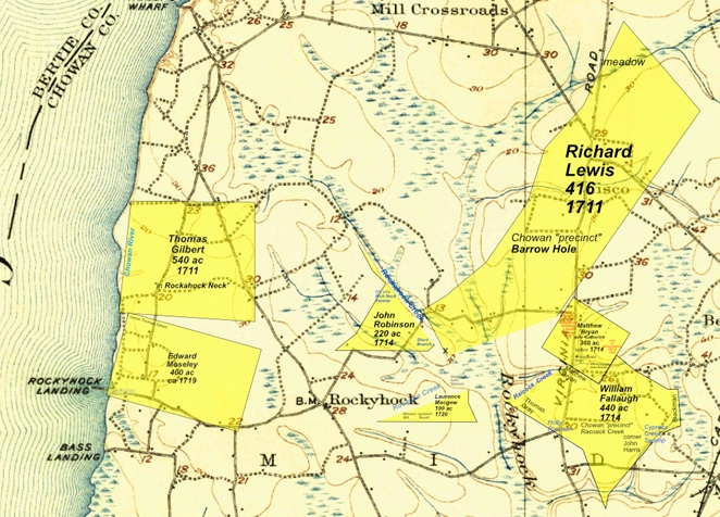
For fellow searcher David Gilbert, the key is to identify any family connection to Thomas Gilbert, who acquired a 540-acre patent near the mouth of Rockyhock Creek. That realization advances his search, but hmmm, I was intrigued by seeing something new and different. A bit to the east, notice that Richard Lewis received a large patent on Rockyhock Creek that calls out “the Barrow hole.” What is a Barrow hole? Clearly, this is in the area where our Joshua Burris likely died some 70 years later. Coincidence, or does this point me in a new direction? I leave you with the idea that our Burris family goes by many naming variants, and that the Barrow hole may somehow refer to our family. This shared discovery may point us in unforeseen directions as our story rewrites itself with each and every new find… Thanks, David!

