Category Archives: Uncategorized

TWO HOLES

OLYMPUS DIGITAL CAMERA
Passing through Misenheimer NC, I’ve driven by this marker more than a hundred times since my days as an NC State student brought me to Raleigh. And never leaving the area, I’m blessed to have enjoyed a long affiliation with the university Crafts Center from which I’m nearing retirement.

I don’t think I have any immediate ties to the Barringer family who owned and ran this profitable mine in the upper corner of rural Stanly County. The Barringer family was a big deal in history with connections to gold, business, politics, and even war. Knowing little about the Barringer family details, I’ve pondered other questions as I passed the historical marker above.  What was it like back then? Did the gold mining destroy the beauty there and did it render the land an eye sore? Looking across the fields and nearby woods, what would it have looked like in the early 1800’s? I also wonder about my distant cousin Hartwell Spain Love and where he lived and what life was like for him?

Some say Hartwell is the son of old grandsire James, the first and oldest of our LOVE family to reside in the area. But, he’s not. Hartwell is instead likely to be the son of a younger James Love whose full name was likely James Allison Love. It’s been believed forever that old grandsire’s full name was James Allison Love, but it’s not. I could rattle on about that fact for hours though that’s not my intent for this post. Instead I wonder about the life of Hartwell Spain Love. He received land across the Rocky River from John Reed’s goldmine. Something happened and he lost his lands before moving to the area of Gold Hill near Barringer’s mine. Listed among many miners in the 1850 census, Hartwell was not enumerated as being a miner. So, what was his purpose in life and why did Hartwell remove himself to live in the neighborhood surrounding Barringer’s mine? Note that within ten years Hartwell moved again. This time to Iredell county where he lived until his death at Elmira NY in a civil war prison camp.

Now, bear with me for a huge change in thought. Two years ago, my wife and I gathered up my mom and met my sister and brother-in-law for a family vacation touring the eastern rim of the Grand Canyon. Paralleling the old Route 66, we left out from Flagstaff with a first stop taking place at a corner in Winslow Arizona. We later headed out across the desert on a horse with no name in search of Meteorite Crater. It’s a big hole and one that must be seen to be believed. Purchased way back when and still owned by the Barringer family, I wondered if there was a connection to the hole smaller in size located in Stanly County NC. Quickly skimming the plaques for clues, I saw mention of Pennsylvania and made the wrong conclusion that the mine was owned by some northern branch of the Barringer family unknown to me.

20115444688_e316c71166_o_tonemapped

And now to the present.  Conrad Weiser, a friend, past Crafts Center director, and Barringer descendant stopped by my office to let me know of a recent find. He shared that the Barringer Meteorite Crater was originally purchased by Daniel Moreau Barringer Jr. who was born in Raleigh NC. His father, born near Concord NC, was a lawyer, represented NC in Congress, and was friend to Abraham Lincoln. Like his father, Daniel Barringer Jr received the finest of education and started a career in law. But, something pulled him in a different direction. A love of geology grew in Daniel Moreau Barringer Jr and led him to write a book on minerals and their commercial values. Like his ancestral family in Cabarrus and Stanly Counties, Daniel sought to find that of value hidden below ground. He purchased the Arizona Meterorite Crater in hopes of finding the meteorite he believed was there.

CONNECTING OUR THOMAS TO WAKE COUNTY (Part 1)

The map below locating THOMAS lands in old Anson County is not meant to be highly accurate. However, the locations indicated are closely identified by land grants and deeds.

thomasThe Thomas family in old upper Anson (now also in Union) settled along the waters of Richardson Creek.  Past history holds to the belief that Benjamin Thomas is our family’s earliest known ancestor. His first appearance in the records of Anson County was as chain carrier for two grants issued to Gideon Green:

Grant #4324, Anson NC, to Gideon Green. Ent 15 Jun 1779, Sur 15 Jun 1779, Iss 11 Oct 1783. For 150 acres south of Rocky River and situated on both sides of Richardson’s Creek. One of the lines of this survey follows the courses of Walnut Branch. Chainers were Salathiel Clifton and Benjamin Thomas. Grant # 4629,

Anson, to Gideon Green. Ent 15 Jun 1779, Sur 15 Jun 1779, Iss 14 Oct 1783. For 50 acres lying on the south side of Richardson’s Creek. Chainers were Salathiel Clifton and Benjamin Thomas.

Benjamin Thomas would not be a land owner himself until well after the revolutionary war when on 26 October 1785 he purchased Gideon’s grant #4324 above. Benjamin Thomas went on to acquire other lands to the north and south of Richardson Creek in the same area.  He would later deed land along the north side of Richardson Creek to “my son” Ezekiel (Map Key A).  This land continued to be identified as lying on Walnut Tree Branch of Richardson Creek.  And near to the branch is the old THOMAS cemetery (see cross) now gone and planted in crops.  This is also the location of Charity Ford, possibly named for Ezekiel’s wife Charity.

The elder Benjamin Thomas deeded his lands on the south side of Richardson Creek to “my son” Ananias (Map Key B). East of Gourdvine Creek, the lands were close to an old Baptist Church near the Edmond Davis Cemetery where Ananias Thomas is buried.

David Thomas, believed strongly to be the son of Benjamin Thomas acquired grants of land along the Flag Fork of the Watery Branch (Map Key C). There’s no record stating specifically that David is the son of Benjamin. However, David named a son Ananias and Benjamin’s son Ananias named a son David.   The honoring by name shows relation and it’s always been believed that it signified that David and Ananias were brothers.   Also, David Thomas moved to Chester County SC around 1810 where family remain in part today with others moving to Blount County Alabama. There is also a deed in Chester County SC where David’s brother Ezekiel Thomas is witnessing land transactions from Michael and Gideon Austin.  Michael lived earlier in Anson and his lands were located close to those of David Thomas.

Benjamin’s son Jacob Thomas married the daughter of John and Sarah O’Neal Edwards and began acquiring grants along Crib’s Creek in present day Burnsville (Map Key D).  Jacob is buried in a family cemetery along the fence line at the right angle turn on Jones Pond Road.  However, because the headstones were being destroyed by farming equipment, they were removed across the road to the old Thomas cemetery where slaves and their descendants are buried.

Old Benjamin deeded his son Benjamin Jr. lands north of that deeded to son Ezekiel (Map Key E). Some believe that old Benjamin married the daughter of his contemporary William Gurley. I do not believe this is true as it was Benjamin Thomas Junior who was of right age and who in fact was bequeathed land from William Gurley’s estate.

As far as tradition goes, this is what we know of the family of Benjamin Thomas.  However, there is another THOMAS living nearby whose records will likely open the door to a deepening family history. Two years prior to Benjamin’s purchase of land from Gideon Green, a Jacob Thomas was issued a land grant (Map Key F) in 1783 on the north side of Richardson Creek. Chainbearers were Joacim Hudson and Thomas Gilbert.


A WARM DAY

DSC_6238_tonemapped.jpg

Here it is March 11 and I’m on my way to my favorite hangout at the corner of Jones and Blount streets. All the trees, shrubs and flowers are greening up for spring as temperatures again soar into the upper 70’s. Nature has changed or have we changed it? Regardless, the flowers and grand old oaks surrounding the nearby Executive Mansion react to the early change in season. And don’t they know? Don’t they know it’s not their time? The flowers will be killed as the nature of all things is playing an ugly trick. There will certainly be more killing frosts before winter submits to the warmth of summer. And yes, new growth and blooming flowers will be killed and next year’s landscape may change just a little. Few of us will notice the change. Only a hand full of us will look deeper into the struggles our plants must overcome to once again bring us flowers in the spring.

Seeking context for a post on Hampton Thomas,  a family member who served in the civil war, I visited archives today with the sole purpose of reading a diary written by James E Green. Finding the inspiration I needed, it hit me when I stepped back out to enjoy the day’s warmth. War happens and it takes our most young and treasured. Like the killing winds of winter, we can try to predict it, but much goes into timing. And like in our anticipation of each new spring’s blooming, we are often duped by the cruel whims of our own human nature.

PT 3. THE DEEDS OF SAMUEL BONDS

IMG_20160119_193620227I really get excited studying land records as the story I’m wanting to tell changes with each new owner. Up to now I’ve centered on Adam Garmon, Joseph Garrott and Burdig Howell, and of their interests in a tract of land encompassing today’s crossing of 24/27 over Rocky River. A future owner moved from this, the lands of my mother’s ancestors and turned south to Anson County where his influence certainly impacted those living near my father’s ancestral family.

Sounds confusing, huh? Early on, I believed what I was seeing in this tract would end up being important. Through land records, I’ve been able to identify a possible church presence in Anson County that may predate recorded history. Before digging into this important post, let’s take one last look at the early title history for our tract of land along Rocky River at the crossing of Hwy 24/27.
mapt

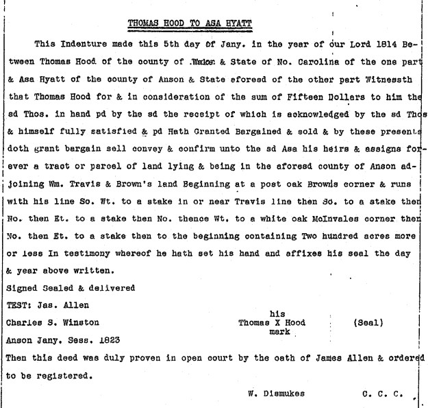
Deed 6-53, Mecklenburg NC, 5 Feb 1771, prv’d 5 Feb 1771. Abner Nash and Justina his wife to Burdig Howell. Being 68 acres, the metes and bounds are: from a w. o. (on the south bank of Rocky River, running thence down the river) 144 to hic., north 66 west 114 to w. o., north 26 east 38 to pine, north 37 west 88 to hic. (on the river), then down the river to begin. Wit: Clement Nash.

Deed 6-128, Mecklenburg NC, 16 Dec 1771, prv’d Apr 1772. Burdig Howell to Peter Kizer.  Jurat: John Polk.
Deed 6-135, Mecklenburg NC, 1 Apr 1772, prv’d Apr 1772. Peter Kizer to Joseph Garrot. Jurat: ___ Polk.
Deed 7-385, Mecklenburg NC, 10 Jan 1774, prv’d (record lost). Joseph (J) and wife Suzana (x) Garrott to William Mitchell Wit: Peter (x) Curzine, Moses (x) Burleson.
Deed 10-475, Mecklenburg NC, 2 Feb 1779, prv’d _____, William Mitchell to Leonard Green. Wit: William Barker, Elizabeth Balch.
Deed 11-323, Mecklenburg NC, 1 Feb 1780, prv’d Apr 1780. Leonard (L) and wife Ann (x) Green to Samuel Bonds, being 68 acres. Wit: William Haynes, Jacob Self. Deed 13-779, Mecklenburg NC, 29 Jan 1789, prv’d Apr 1790. Samuel Bonds to Michael Garmon. Wit: Willi Potts, John McGuirt, Arch, White.

In 1779, William Mitchell sold this tract to Leonard Green who I firmly believe moved from what’s now southern Wake County where he was listed in county road orders. He must somehow be connected with the families of Richard Green and Gideon Green who settled in Anson and Montgomery Counties. As I’ll dedicate more time on Leonard Green at a later point, let’s move beyond the conveyance by Leonard and wife Ann to Samuel Bonds.

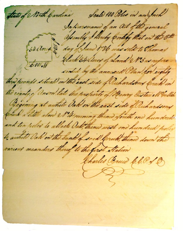
Samuel Bonds bought the tract at the crossing of Hwy 24/27 in 1780. A time when the Revolutionary War was just reaching the south, I suppose he lived there until selling the land in 1789. Not appearing in the 1790 Mecklenburg County census, Samuel shows up in Anson County where he received a land grant. Entered 15 Jul 1793, and issued 9 Jul 1794, Grant 5038 Anson NC was located on the south side of Richardson Creek where it adjoined lands of Layce. Shortly after, on 19 Jan 1795, Samuel Bonds purchased 54 acres on Richardson above No. 4 from Charles Calloway of Rockingham County NC (Deed C2-481 Anson NC). Witnesses were R. Galloway and Chappell Bonds. This land was originally owned by Henry Eustace McCulloh, a British land agent responsible for most of the development in western NC. Charles Galloway had acquired the tract from Thomas Clark who received it via the following Secretary of State grant of confiscated lands:

DSC_4851.tif.jpg

Samuel Bonds was on the move again as he’s enumerated in the 1800 Kershaw County SC census near sons Chappell and Seth Bonds. From the footnotes in Leah Towsend’s South Carolina Baptists 1760-1805 reads:

Gum Branch CB, 1796-1800, 1806; Rev. Samuel Bonds probably came to S.C. from N.C.; he had a survey in the fork of Sammy Swamp on Pretty Branch in 1784, but is not listed in S.C. in 1790; nothing is known of him after he left Lower Fork of Lynches Creek Church (Col. Rec. N.C., IV, 518; Plats, VIIq, 468

So, we now know Samuel Bonds was in SC as early as 1784 where church records list him as minister of Lynches Creek Lower Forks Baptist Church from 1795-1998. Per historical marker, and constituted in 1789, the church held early meetings at Lower Fork of Lynches Creek, Boggy Swamp and Witherinton´s Mill. By 1798, the church was located as mapped below and its name was later simplified to Gum Swamp Baptist Church. Of interest, Samuel Bonds proceeded Rev. James Hudson who was minister at Lower Lynches Creek in 1794. He was also listed as minister alongside Samuel Bonds in 1795. James is likely the son or close family member to Joachim Hudson who lived close to Samuel Bonds along Richardson Creek in Anson County NC.

And further information from the diary of Rev. Evan Pugh:

From May, 1789, to May, 1797, Mr. Pugh generally preached the first Sunday in the month at Black Creek. Rev. James Coleman, licensed preacher and messenger of the Cashaway-Mount Pleasant Church to the Charleston Association in 1795, was meantime working at Black Creek branch which was constituted a separate body on August 11, 1798, with eighteen members, by Rev. Messrs. David Cooper and Samuel Bonds. Black Creek immediately asked Mount Pleasant to give James Coleman a letter of dismissal, and on November 30, 1798, a presbytery consisting of Rev. Messrs. Samuel Bonds and David Cooper ordained him as pastor of the new church. Mr. Coleman, together with Charles Williams, secretary of the church, appeared at the Charleston Association meeting of 1799 and secured admission. Black Creek Church showed strong effects of revival.

There is no note of a meeting at Gum Branch until July 13, 1798, but the records are incomplete for the intervening year. At that time, bitter dissension had arisen in the church because Brother Samuel Bonds had brought an accusation of forging an order against the son of one of the members and had had a warrant made out against him after the charge was apparently disproved. This many members thought unchristian of their pastor. Brother William Witherington refused to commune, said he did not consider himself one of the church, and also declared that if the land had been his over which Rev. Mr. Bonds had opened a path to the meeting house he would “check him with the law.” Fellowship was withdrawn from Mr. Witherington and a presbytery consisting of James Coleman, John Sanders, Pigg and Waddill justified Mr. Bond’s conduct, but the church was dangerously near extinction due to this and a later breach. Mr. Bonds soon left.

Where did Samuel go from here? His sons are found later in Lee County GA. And printed in Tarorough NC, the following highlighted letter from his grandson appeared in a 1845 publication titled The Primitive Baptist:

primitivebaptist1011benn_0093

________________________________________

It’s time to bring this story to an end, so let’s conclude with a review of related records in North Carolina.

Firstly, knowing Samuel Bonds once lived just below Haynes Baptist meeting House, was he involved or likely even a minister at the church? Was that the start of his spiritual journey? Was he at all connected to Meadow Creek Primitive Baptist Church, an early church just across the river? Note that Persilar Bonds was mentioned in that church’s minutes:

1803 – Persilar Bonds was excluded for lying about potatoes.

Not the most flattering of entries, is there any possibility Persilar Bonds is related to Samuel? I dunno…

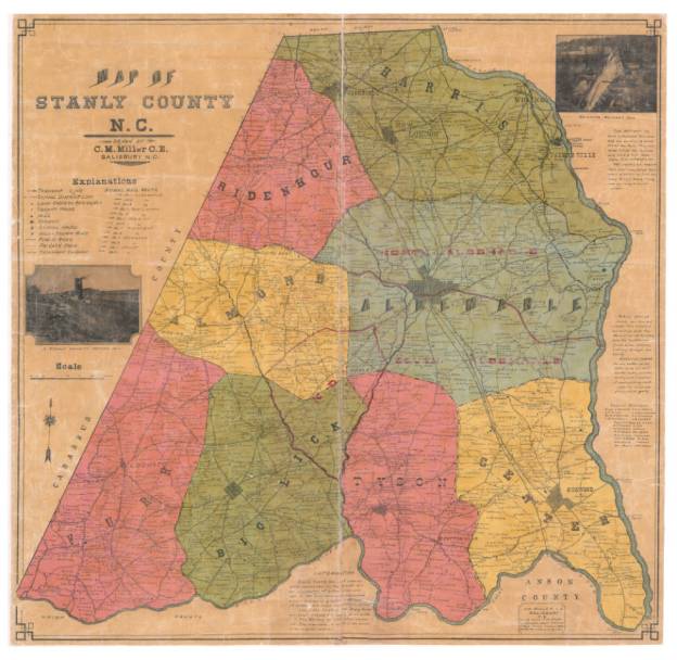
And moving to Anson County, we’ve discussed a deed for land once owned by British Land Agent Henry Eustace McCulloh. I’ve yet to physically locate the land though Samuel Bonds Grant 5038 Anson NC ties to a historic old church:

bonds

The above was issued to Samuel Bonds in 1794. Of all places, the tract clearly encompasses present day Jerusalem Primitive Baptist Church. Note I’m early on in my mapping project, so this could easily be off enough to where the old church may lay outside of the land bounds. Also, though there’s no record of Samuel Bonds later conveying the land, a search through deeds reveals an interesting title history:

Deed S-72 Anson NC, 7 Oct 1816, prv’d Jan 1822. William Curlee to Benjamin Oneal. Wit: George Hobbs, John (x) Wilkinson.
Deed U-28 Anson NC, 7 Oct 1821, prv’d Jan 1822. Benjamin Oneal Sr and Jr to Willie Baucom. Wit: Myrick Harward, Asa Baucom.
Deed Y-328 Anson NC, 10 May 1830, prv’d Sep 1833. Willie Baucom to Charles Austin. Wit: Myrick Harward, Wyatt Nance, Jas Broadway.

It’s believed that Jerusalem Primitive Baptist  was formed in the 1830’s. Is it possible that Samuel Bonds was involved briefly in a meeting in the same location that predates Jerusalem? Could something that began in his day and time have been instrumental in locating Jerusalem Primitive Baptist church where it stand today? I truly have no idea but have enjoyed the chase, of learning how the life and actions of this one person could cross county and state lines raising such possibilities.


PT. 2: JOSEPH GARROTT’S STAY IN MECKLENBURG

Wake County NC was cut from corners of Orange, Johnston and Cumberland counties in 1771. The town of Raleigh was not yet conceived as in 1788 the site was chosen specifically to become the state’s new capital. Raleigh wasn’t incorporated as such until 1792. There’s no real reason to tell you this other than during the time period 1772 and 1800 there seemed to be a steady migration from the area of Wake County to what’s now the areas between Anson and Cabarrus Counties NC. That, and as a teacher in 1980’s Wake County, I remember the name Garrott or Garrett as being common.

In early winter, on 17 Dec 1771, Burdig Howell sold his 68 acres encompassing present day Rocky River bridge to Peter Ciser/Kiser/Keiser (Deed 6-128, Mecklenburg NC). Peter sold the land to Joseph Garrott on 1 April 1772. Joseph didn’t hold on to it long as he and wife Susana sold the tract on 10 Jan 1774 to William Mitchell (Deed 7-385, Mecklenburg NC). Of special interest, William Mitchell owned land adjoining William Haynes, the likely namesake of Haynes Baptist Meeting House. William Haynes removed to Burke County in western North Carolina where he founded Bill’s Baptist Church near Chimney Rock in present day Lake Lure NC.

There’s no further record for Joseph Garrott in the area of Cabarrus or old Mecklenburg NC. There is however a family of that name that expanded out of Maryland along numerous routes through North Carolina. About the time Joseph sold his land in Mecklenburg NC a Joseph Garrott and others appear in Laurens County SC. I don’t have access to the best of records for SC though online, descendants indicate that family may have passed earlier through Pitt County NC. If so, and only as a what-if, early Cabarrus County would have made for a timely stopping point in their migration south.

Were there others from Cabarrus who moved to Laurens County SC?   Yes, apparently a David Templeton from Coddle Creek made the move. One of his family married the daughter of a person named Joseph Garrott in Laurens County.

And how about Adam Garmon? All Garmon histories line up a bunch of Michaels punctuated by a George early on. There must have been more branches than just those named Michael!

Dated 7 Apr 1779, Thomas Polk (Attorney for David Oliphant) sold land to Adam Garmon (Deed 7-84, Mecklenburg NC). Shaded in darker green below, this tract of 72 acres lies on the “waters of Rockie River neigh the Baptist Meeting House.” The deed is the definitive document used to identify Haynes Meeting House as an early church located just up the hill from the Rocky River bridge.

lowermap

Living on the land for less than a year, on 12 Sep 1779, Adam Garmon and wife sold the land around Haynes Meeting House to Henry Kent of Wake County (Deed 11-31, Mecklenburg NC). In a corresponding deed in Wake County, Henry Kent of now Mecklenburg sells his land on Utley Creek in Wake to Davie Straight. There’s no record of Henry selling his land in Cabarrus though he does appear in the 1800 Kershaw County SC census. Henry’s not alone as others also moved from Cabarrus and Anson to Kershaw SC. And note there are many in Anson County who once lived in the area of Utley Creek, Wake County.

Selling his land near the Baptist meeting house, Adam Garmon magically disappears and is no longer found in the area. There’s no known family ties or other information clearly locating his whereabouts. But just as quickly as he disappeared, another person named Adam Garmon shows up on Rabon Creek in Laurens County SC. And this Adam had a son named (surprise surprise) …Micheal, but of course!

Could Adam Garmon and Joseph Garrott have moved to Laurens County SC together or as part of the same migration?   I dunno though I’ve marked the following 1825 map of Laurens County with possible locations they settled upon. There’s a Garrott mill in the northeast corner on Copper Creek (marked by a red star). Further south and west we know Adam Garmon acquired land on Rabon’s Creek (marked by a blue star). The map is courtesy of the Library of Congress.

laurens

As my ancestor Jonah Love married Sally Garmon, the history of this family has always been important to me. And knowing of Adam, and of so little out there on him, it would be wonderful to identify him and his descendants as kin. To make this happen, I hope for DNA testing by members of both the Cabarrus County NC and Laurens County SC families. It’s easy to do and just requires action by those who are truly interested to know about their past.   Together we can do great things; let’s work together and tear down that wall!

teardown


PT. 1: THANK YOU BURDIG …whoever you are!

lowermap

lands of Burdig Howell – yellow

Dead Man’s Curve and Hell’s Half-Acre, and for many my age, there’s also fond memories of the bridge where Hwy 24/27 crosses Rocky River. I remember as a kid hanging my head out of the car to capture a glimpse of the flowing waters below. There was a large farmhouse, and we passed a single engine airplane and grass runway. My dad gauged the growing season as we drove by cornfields on the long descending curve. Raised in the city, this crossing over was an important part of my life. Not only did it carry me to my country cousins, it also introduced me to a whole other way of life.

In studying this area of southern Cabarrus County, I believe there’s a need to initiate a little online discussion into the lives of three particular settlers who lived oh so briefly near the present day Rocky River bridge. There’s Burdig Howell with lands not far from possible family member Joseph Howell. And in follow-up posts, I’d like to discuss Samuel Bonds who may have woven himself through the annals of Cabarrus and Anson before moving to SC. And finally, a person named Joseph Garrott just may provide new clues into a probable Garmon family member who escapes connection.

_______________________________________

We know of Joseph Howell and of his land near the mouth of Anderson Creek (located north of our Rocky River bridge). Joseph’s mother is buried at Haynes Baptist meeting house not far up the hill from the bridge. The church is long gone though the cemetery is marked by a cross in the green shaded tract above. It’s curious that early on, Joseph also acquired land very close to present day Bethel UMC.

About the same time, a little known person by the name of Burdig Howell purchased 68 acres from Abner Nash and wife Justina (Deed 6-53, Mecklenburg NC, 5 Feb 1771). The tract is situated along the Rocky River and takes in the crossing of Hwy 24/27 (see above shaded in yellow). It’s close to Joseph Howell’s land and just downhill from the ancient site of Haynes meeting house. Was Burdig kin to Joseph Howell?   And, if so …how?

Burdig Howell didn’t hold on to his land for long as he sold it to Peter Kizer late in the same year (Deed 6-128, Mecklenburg NC, 16 Dec 1771).

Scan_20160115 (2)

-land warrant for Charles Hart

Over a decade later, on 27 Oct 1782,a warrant  (Grant 3510 Mecklenburg NC) issued to Charles Hart identifies adjoining landowners as David Caigle and “Burdick Howell.” Located a little further north, Charles Hart’s land was situated on both sides of Rocky River just above the lands of Joseph Howell. Within two years after being warranted, the survey for the land no longer mentioned Burdick Howell.   Was Burdg still local; where did he go?


hagans

-survey for William Hagans

A year after being mentioned in Charles Hart’s land grant, Burdig shows up more than 20 miles to the south on Twelve Mile Creek. On 21 May 1773 (Grant 2632 Mecklenburg NC),  the survey for William Hagans describes a tract as being “on the waters of 12 mile creek including the improvement Burdick Howell now lives on.”

There’s no further mention of Burdig Howell. Working from the other end of his life story, descendants know him as Thomas Burdig Howell. Online discussions indicate that Burdig Howell removed from North Carolina and eventually settled around Greene and Hancock counties GA.

Later conveyances of the lands of Burdig Howell may add to the richness of early history while potentially opening the door to new family leads. The next post will cover land conveyances by Adam Garmon and Joseph Garrott.

A DISAPPEARING MAP ACT

Charlotte skyline

Charlotte skyline


Every time I drive home to Charlotte my visual impression is dominated by the expanding skyline. It’s cool! Charlotte, like most towns and cities, is growing at rapid pace. The landscape is quickly changing to a point I’m now loosing my way around. My phone is my map and my own memory is no longer needed. It’s deeply sad to see the old maps disregarded and even being destroyed as a result of the computer age.

As an arm chair history buff, the evolution of one type of map scares me. Looking at old land grants and deeds, I like to compare their old surveys to present day property tax maps. Finding some of the original boundaries, it’s a fabulous tool for connecting ancient landholdings to the modern world. But the end is in sight, the resource is disappearing and the blame is twofold.

Can you imagine using today’s county tax maps to find the original land grants as they were once located in what’s now downtown Charlotte? There’s no source for doing so as the degree of urbanization makes it impossible. But joy-joy …out in the rural areas old farms and forests are sometimes bounded by survey lines rooted in the original land grants. Highly valuable, these too are disappearing as urban sprawl invades the “country.” Just last week I heard folks talking about the town of Locust and how you’d better buy up land now as it was disappearing fast! hmmmm…

Along with the urbanization of rural lands, we’re also more efficient in how land is recorded. No longer do we have the old hard-copy books filled with plats and no longer do we have a hard copy county tax map. Plats are updated online as land is bought, sold and developed. It’s ever-changing nature destroys memory just as does an eraser on a chalk board. Does an annually published county tax map census exist? Maybe, but I question access and whether or not those in charge understand and support the public need to explore our past. GIS is a powerful tool, I just hope for a governmental act requiring an annual census of county tax maps.

Years ago my fear led me to visit local court houses in order to copy tax maps in the areas I research. Take a look, this may be of help to you!

2000 Tax Map for southern Cabarrus County

2005 Tax Map for southwest Stanly County

SOMETIMES YOU FIND WHAT YOU’RE NOT LOOKING FOR

Today we failed  to locate a cemetery near the old home place of Annis Nance Thomas.  Not sure what to think and what can be done at this point; Annie Lee and I walked it, Ms Emma verbally validated it, but I’m thinking it must be gone. But the day was not at all a wash!  I remembered seeing a cool old shack on Jerusalem Church Road and remember Annie Lee pointing out a field where once stood the home of Jacob and Hester Holly Thomas.  We drove to the area where we came across Tommy Turner working in his yard.  Tommy knew nothing of the old home place …I’m thinking it was a bit further down the road.  He did though show us the way to an ancient cemetery on his father Reece Turner’s land. It’s a place I had never heard about!

We walked our way to the back end of the property to a stand of trees on a hill that rises over either Little Watery or Flag Fork Branch. It’s been rainy to say the least and surprisingly …we made it with shoes in tact!  Here it is, take a look:

There are some uniquely beautiful old markers at the cemetery and I’m sure its location will play into future mapping plans.  I photographed what I saw and may need to go back to look more closely. Click here to see the stones.

It’s great to see such old places. We need more people like Mr Turner who care for these ancient sites. Their doing so enables us to rediscover the stories of our past. …Thank you Mr Turner!


A FUN LOOK BACK

It’s a gray and dreary New Year’s day, so I’m kicked back, watching a bit of UNC Explorer TV and sharing memories with mom driven from the old 1905 map of Stanly County.  There’s a Smyrna and Lymra church located near where Love’s Grove UMC now stands.  And the Polk Ford road over to Love’s chapel crosses just above Chapel before passing by Clark’s Grove Baptist. And hey, in 1772 the route was likely the main highway from Charlotte to Elizabethtown!

I can also see my G-grandfather George Thomas’ home and store.  I’ve heard old folks talk about him journeying to Charlotte by wagon to load up on goods to sell.

Take a look and wonder around a bit.  Here’s the large searchable map of old Stanly County.

Can you find something you’ve always wondered about?  Where did YOUR grandparents or great-grandparents live?