I’m not a Stanly native and what I know of the place comes from books, legal records, and mostly from what I’ve grown up hearing from relatives on both sides of my family. Recently, friend and fellow blogger Tammie Rabun Hudson wrote an in-depth piece on the “Witch of Big Lick.” Titled “Facts and Fairy Tales: The Real Story of Lynn Bird,” the story told by Tammie is much different than what I have heard in passing. And in her telling of the story I came to learn that my distant cousin Melinda Pless, AKA Lynn Bird, was “the” person accused in tales as being a local witch who lived in the community of Big Lick. Before reading this post, I strongly encourage you to read Tammie’s compelling narrative on this local Stanly County lore. And to say clearly, it seems Tammie was able to connect the dots between the people and the related events though neither she nor myself have found any compelling information verifying that my great grandmother’s aunt Melinda Pless, was indeed a witch. Melinda may have been scary, and surely she was “different”, though records do not support that she was ever one of them boo-scary kind of witches we read about in fairy tales. Let me offer a little back story on why this whole idea is of importance to me.
My father grew up on Big Lick Road in the 1920’s and loved to share stories from his youth. He especially spoke of the hard times, joining the Civilian Conservation Corps and heading west on train during the Great Depression. Of his childhood, dad spoke of those difficult years, of snaring songbirds for basic sustenance. Times were indeed hard though his mother Eva Burris Thomas was an angel while his father Daniel Arthur was known to be a hard sort of man. Until now, I never realized that as children, my father’s parents once lived on the same piece of land where they likely shared time as children. And it so happens that this piece of land earlier belonged to none other that Lynn Bird, the so-called witch.
I remember, many times, my dad standing on the porch of his old home place, pointing across the turnip patch towards Big Lick Road to where his childhood fears had yet to release their grip on him. He told of walking the road home from school in Oakboro by moonlight late in the evenings and having to gather nerve to run past the old graveyard where he declares he saw spooks. He certainly passed the old Green-Carver Cemetery, once larger and maybe more scary than the sanitized setting and few stones that remain today. Is that what he remembered? After reading Tammie’s story, and digging a bit into lands I had platted in the area, I realized that my efforts connected to Tammie’s post about the witch. Little had I known while growing up, my Thomas family’s annual Christmas Eve gathering at the West Stanly Saddle Club occurred at a place important to my father’s grandpa G. W Thomas who happens to be my namesake. The place nearby was also important to my grandma’s parents. And, it is also important in connection to the story of Lynn the witch. The modern-day saddle club is located near the heart of the community and all of the happenings occurred on the route my dad frequently walked in the dark from school. Did he know of the witch? What had he learned from his family and how did those memories play into the stories I never quite understood?
In this post, I’ll tell of the lands in the neighborhood as they relate to Tammie’s findings on the Witch of Big Lick. However, note that the following is a land-based report with no additional info on the witch herself. For that, again I ask you to read Tammie’s post. I do hope the two narratives together will provide a more meaningful context for the life of Melinda Pless, who happened to be the daughter of Peter Pless. She was also known as the Witch of Big Lick. And like every good witch story, I hope the following crumbs of land records will offer a safe path for navigating the landscape where this occurrence took place, a long time ago.
__________________________________
Below, you see the red shaded Ridge Road heading southeast before changing its name to Main Street (Oakboro) at its intersection with Big Lick Road. Once following the basic path of the main ca. 1771 road leading from Charlotte to Elizabeth Town, also known locally in time as the Old Polk Ford Road, Big Lick Road runs to the west, crossing over the blue shaded Cucumber Creek. See them?

Back around 1838, Charles Pless, son of Peter, and many others in the community moved west to Pope County Arkansas for reasons remaining unclear. Charles would settle along the north shore of the Arkansas River on granted land “West of the Cherokee Reservation”. He was joined by his sister Catherine and her husband George H. Teeter who had lived on the Cabarrus/Stanly line north of present-day Hwy 24/27. Others in the Pless family made the trip including possibly Peter Pless, the father who acquired a land grant in Pope County though who is known to have lived out his life and died in Stanly County.
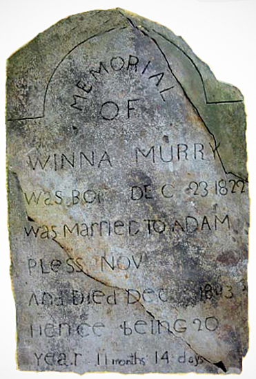
Much later (ca. 1861), and again for reasons not fully known, another migration headed west to Arkansas. At that time, John Adam Pless, a younger brother in the family, would make the journey. Adam earlier married Winna Julina Murray who Tammie Rabun Hudson indicates may be the child of a mixed-race family, a possibility much more common than tradition would have us believe. Winna died in 1843 and is buried at Flat Rock Lutheran Cemetery in Stanfield. John Adam married second ca. 1845 to Catherine Efird, daughter of Martin and Mary Coble. Mary is the daughter of David Coble and had been married first to Levi Honeycutt.
In 1850, John Adam Pless purchased 119 acres, being a break-up parcel of the Great Tract (Deed 6-44 Stanly). Identified as tract #1 in the master plat illustration above, at the time of conveyance the land joined Jesse Morton to the west and Gideon Morgan to the north and east where the land also joined “Austin Road,” now Liberty Hill Church Road. About the Gideon Morgan tract to the north, originating as a conveyance from Joseph Marshall to Solomon Hathcock and identified as tract 2 above, Gideon purchased the 534 acres from Solomon Burris (Deed 19-517 Stanly). The western half of that large tract was sold to David Burris (Deed 19-519 Stanly) with the eastern half being sold to J. A. Morgan (Deed 8-99, Stanly).
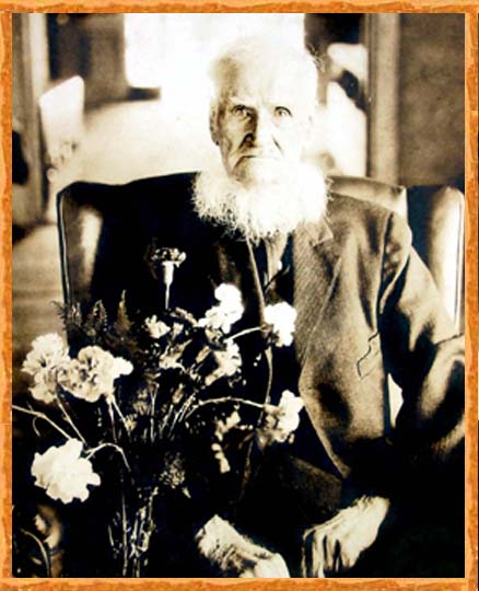
John Adam Pless settled on lands in Arkansas between Pless Mountain and Shinn Mountain north of London Arkansas. Adam lived a long and prosperous life as appears in the following 1923 announcement of his 100th birthday.
 John Adam Pless lived a few years beyond hs 100th birthday as he died in 1927 at which time his grave was marked by family as “Pioneer, Patriarch, and Patriot.” The above photograph of Adam with flowers was, I believe, snapped at his 100th birthday celebration.
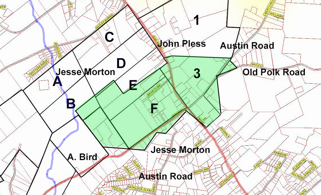 Looking back to the plat map above, Jesse Morton sold tract #3 to William A. Morton (Deed 5-396, Stanly). The eastern boundary of the tract joined Austin Road while the northwest corners adjoined the lands of John Pless. As seen to the left in green, this tract is but a parcel cut from a larger tract conveyed to Isiah H. Coley, being part of the break-up of the Great Tract (Deed 3-148, Stanly). Note that the early conveyance to Isiah Coley identifies both Old Polk Road and Austin Road. Polk Road followed the old Big Lick Rod before crossing over somehow running the path of St, Martin’s Road. Neighboring landowners are mentioned of which one is A. Bird. Remember from Tammie Rabun Hudson’s post that Melinda Pless, Witch of Big Lick and sister of John Adam, married James A. Coble before he died during the Civil War. Melinda married second the much older Charles Bird, son of the above-mentioned A. or Andrew Bird. Somewhere near his lands records should guide us in visualizing events as they happened.
Before delving into the Bird, Pless, and Coble dilemma, take a look at the illustrated tracts #A-F. In May 1864, the estate of Jesse Morton deceased (Deed 5-456, Stanly) was divided among his heirs as listed:
- To Rufus Morton – Absalom Hahn to the north
- To Jesse F, Morton – Joining the Coley tract on a line of his old 200 tract.
- To Martha Almond – Absalom Hahn to the north and Sidney Smith to the east.
- To Elizabeth Hartsell – Sidney Smith to the east
- To David Morton – W. A. Morton to the east
- To Lucy Smith – W. Irvin Morgan to the west (excluding 1 acre for the [Big Lick] church)
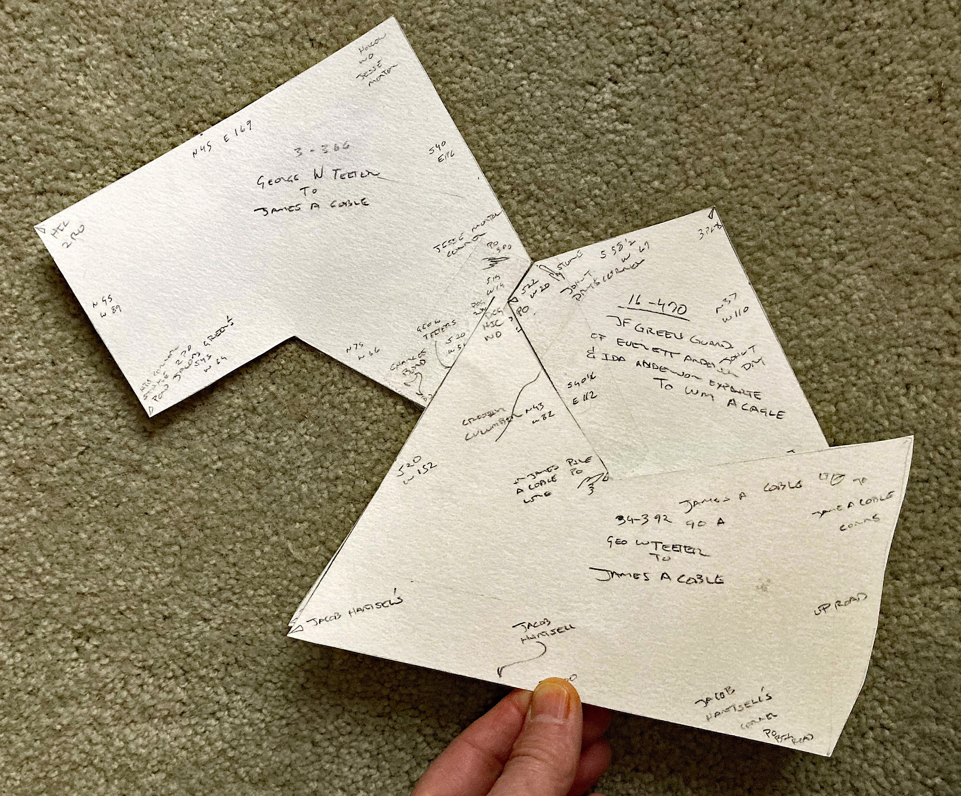
Keeping in mind the location of Andrew Bird’s land and looking at the master plat map above, tract #4 was conveyed in the early 1850’s from George W. Teeter to James A. Coble (Deed 3-336, Stanly). The deed mentions Jesse Morton to the east, Jacob Green to the west, Charles Bird to the south and A. Bird to the southeast. George W. Teeter, not to be confused with George H. Teeter, married Elizabeth, the daughter of Andrew Bird and they later removed to Cabarrus County. Also, note that James A Coble married Melinda Pless about the time of this transaction. This whole idea goes to show that Charles Bird, Melinda’s second husband, was actually a next-door neighbor. And looking at this tract on the Stanly County GIS page, note the southwest side of tract # 4 intersects the end of Saddle Club Road. That’s where the West-Stanly Saddle Club is located happening to be on or next to the lands once owned by my distant cousin Melinda Pless, the so-called witch of Big Lick. It is also the place were I enjoyed many Christmas Eve meals with my family.
George W. Teeter sold a second tract to James A. Coble in 1852 (Deed 34-392, Stanly). Identified as tract # 5 above, the deeded land crosses Cucumber Creek while joining Jacob Hartsell to the south and “The Big Road” to the east. The deed does not give dimensions for the distances of lines along and leading from the road, so I cannot say with certainty whether the eastern side of the tract abutted present-day Swift road or an older iteration running nearby. Of major importance, the trapezoidal shaped western portion of the tract # 5 was later sold by Titus Coble and wife to E. A. Anderson (Deed 43-82, Stanly). See it in the maser plat? This tract was defined in the deed as being “Lot 2 of the lands of Melinda Byrd”. The deed also refers to the easterly abutting land as being Lot 1 of the estate. Per Tammie Rabun Hudson’s article, Everette A. Anderson clearly fits into the family story.
There’s one other tract that’s relevant to the story of Melinda Bird. I’ve yet to find origination in terms of ownership though the title history of tract # 6 connects with two of my direct ancestors. Going back to the estate of Melinda Bird, J. F. Green, Guardian of Everette and Ida Anderson sold the land to William A. Cagle (Deed 16-470). At that time the land joined John T. Dry to the southeast.
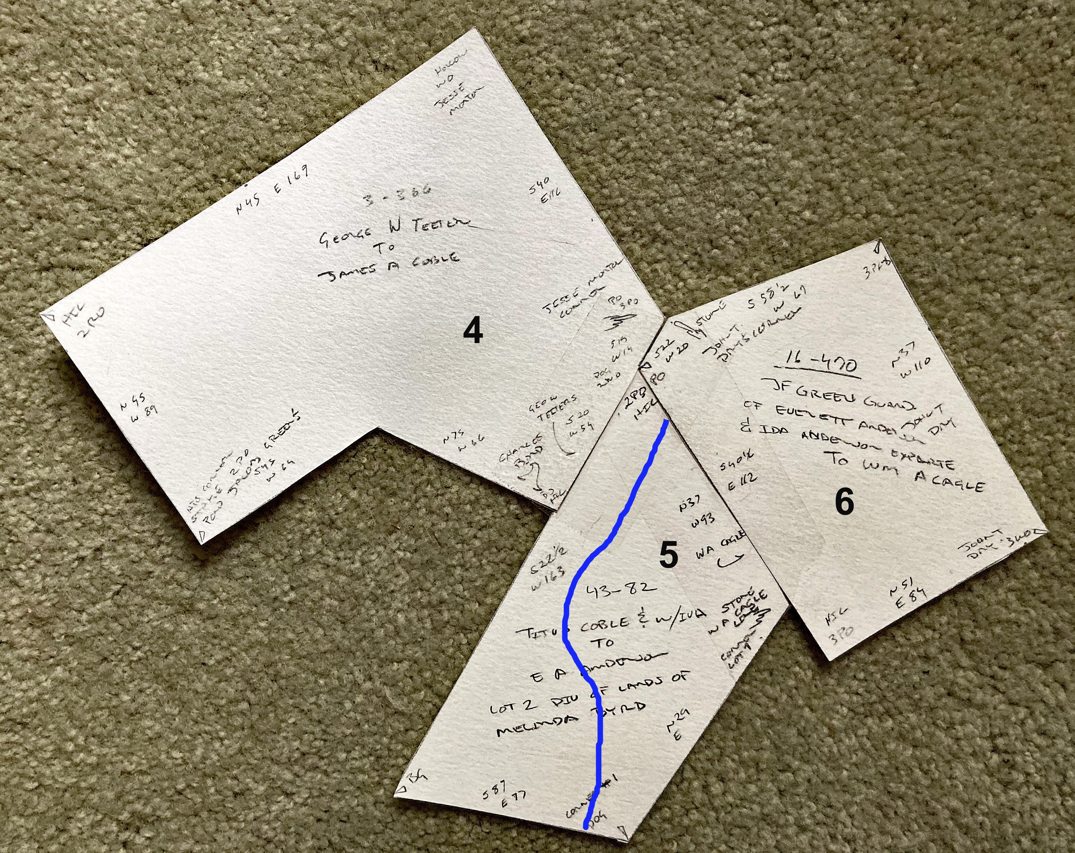 To the right are the three platted pieces of land (tracts 4, 5, & 6) most relevant to this report. Their orientation to the surrounding community is easily discerned on the Stanly County GIS map. Also, note that I’ve penned in the flow of Cucumber Creek. And below, the image orients Jams A. Coble’s larger tract #5 that he purchased from George W. Teeter.
In the next image, we see that tract # 6 nearly doubled in size to the east when S. S. Lilly and wife Martha later sold it to Tabitha J. Rowland (Deed 24-264, Stanly). Tabitha is the daughter of Andrew J. and Mary Ann Crayton Huneycutt. Tabitha married Thomas J. Rowland. Tabitha purchased the land at a time when the neighbors were identified in the deed as C. A. Huneycutt to the northwest, Yow to the southwest, Huneycutt to the southeast, and Pless to the northeast. I’ve yet to find a deed for the Pless land. Tabitha later sold the northeast corner of the tract to William H. Sasser (Deed 127-80, Stanly).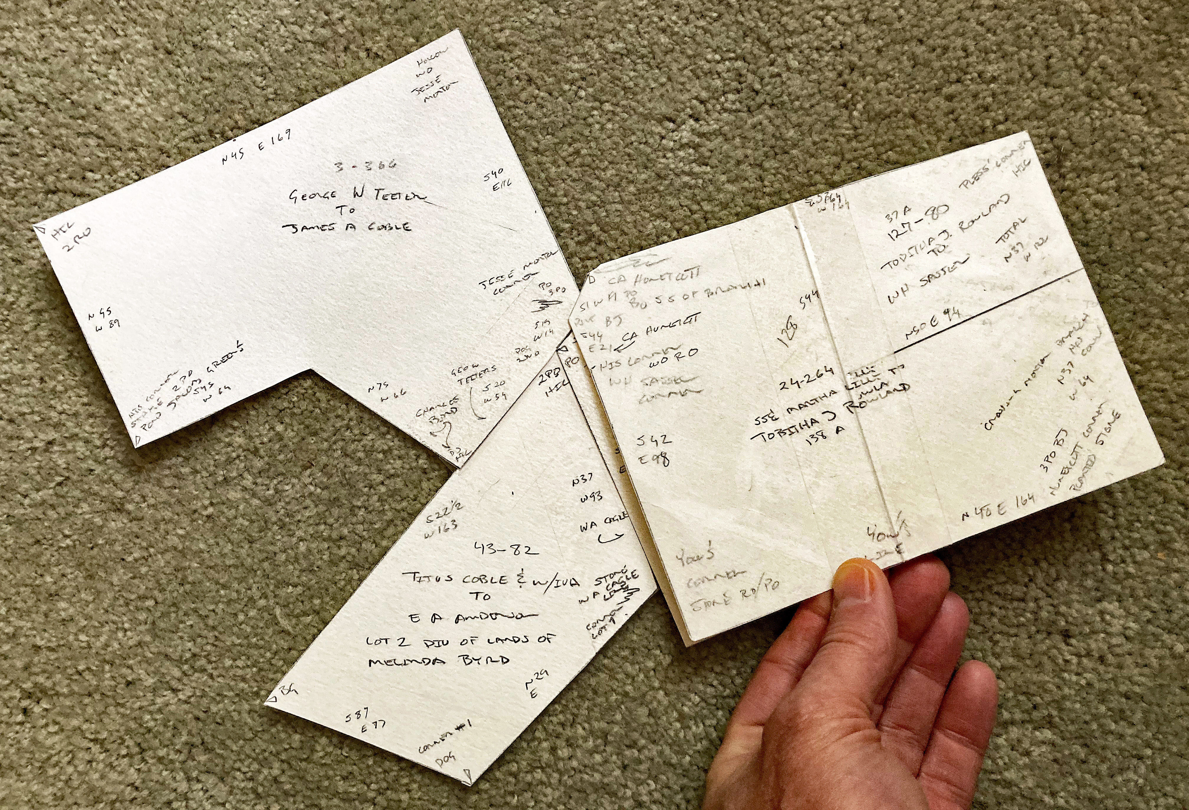
Now a drum roll please ….And as seen below, in 1899 Tabitha J. Rowland sold 68 acres, being the western half of the land, to G. W. Thomas who happens to be my great grandfather (Deed 33-460 Stanly). And then ten years later, for some reason, J. H. C. Flowe sold the same land to George H. Burris who is my grandmother’s father (Deed 40-46, Stanly).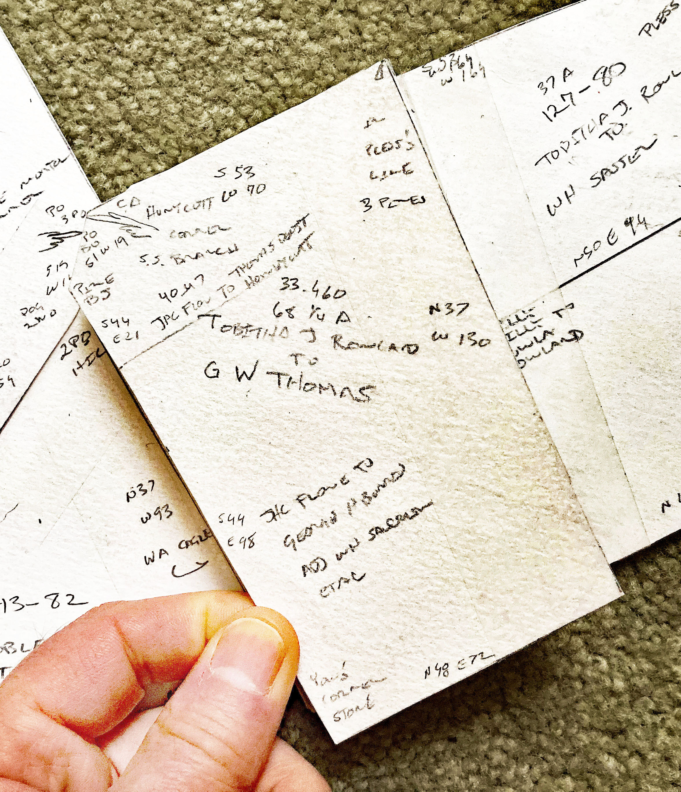
The last tract shown near the top of this post on the master plat map is tract # 7 which was deeded to Jacob Green as a part of the break-up of the Great Tract (Deed 6-436 Stanly). The large 212-acre tract adjoined Holden Hartsell land to the south and was later conveyed by William Hartsell to William R. Hartsell (Deed 10-154 Stanly). The Green-Carver cemetery that my dad walked by as a child is located along Big-Lick Road within the heart of this piece of land.
Seeing how close the cemetery was located to Melinda’s land, and how both my grandfather and grandmother’s parents had real estate connections to the land, I have to wonder if as children, did my grandparents live in fear of old Aunt Melinda? Did they play around the old home, did they dare the spirits, or did they walk quietly in fear in passing the place as did my dad? I think that as a child my dad likely grew up hearing these stories. And whether or not Melinda was truly a witch, hearing of the details as told by Tammie Rabun Hudson and others takes on a different meaning when you are able to physically connect landscape, family, and stories occurring long ago.
