Key Map and Legal Descriptions of Grants and Conveyances
in present day Union County
Located South of Richardson Creek.
1. Grant 4876, Anson NC, ent. 17 Mar 1787, sur. 5 May 1789, iss. 16 Nov 1790. Issued to CHARLES COOK, being 150 acres on the west side of Richardson Creek “about half a mile below the mouth of Negro Head Creek including an improvement by James Trull.” Running south 47 west 80 poles to a post oak, then north 85 west 140 poles crossing Richardson Creek to a white oak, then south 44 poles up said creek to a white oak and willow oak, then south 50 east 100 poles to a stake, then north 73 east 130 poles to a stake, then north 79 west to the beginning. Chainbearers: William Stewart, George Ford.
Deed D-168, Anson NC, 12 Mar 1796, rec. Apr 1796. Charles Cook Senr to John Coburn, being 100 acres of land beginning at a red oak on the north side of Richardson Creek and running south 47 east 80 poles to a post oak, then with said line to Richardson Creek, then down the said creek to the beginning. Wit: William Morton, Jordan (x) Jones.
Deed G-196, Anson NC, 10 Jun 1797, rec. Jul 1800. Charles Cook to Solomon Mullis being 50 acres, a tract of 50 acres joining Solomon Mullis on the south side of Richardson Creek beginning on the said creek at a white oak running then up said creek to Solomon Mullis’ line, then along said Mullis’ line to a stake then round the line that was run by Charles Cook containing all of the land south of the creek. Wit: Frances (x) Coburn, Lydia (x) Coburn, John (x) Cobb.
2. Grant 6931, Anson NC, ent. 23 Aug 1831, sur. 23 Jan 1832, iss. 18 Dec 1833. Issued to JOHN WOOTEN being 150 acres on Negrohead Creek joining Jacob Mullis beginning at a forked birch on the north bank of Richardson’s Creek Benton’s corner and runs south 61 east crossing the creek 28 chains to a stake Jacob Mullis’ corner, then south 5 west 40 chains to a stake in Wooten’s own line, then with his line south 60 east 20 chains to a post oak pine and red oak his corner, then south 75 east 13 chains to a stake on the bank of Negrohead, then down the said creek North 10 west 35 chains to a stake by two white oaks in Solomon Mullis’ line, then with his line north 15 west 39 chains to Richardson Creek, then up the said creek to the beginning. Chainbearers: Jesse Barnett, Holden Mullis.
3. Grant 5176, Anson NC, ent. 15 Oct 1794, sur. 25 Jan 1795, iss. 10 Jul 1797. Issued to WILLIAM STEWART, “being 80 acres between Negrohead Creek and Richardson Creek including Rutherford’s camping ground” beginning at a black oak among oaks the runs south 59 east 40 chains to a post with a post oak and black oak, then north 31 east 18 chains to an elm on the bank of Negrohead creek, then north 37 west 6 chains down the creek to a white oak, then north 59 west 34.5 chains to a stake among three pines, then to the beginning. Chainbearers: Josiah Stewart, Joseph Rogers.
4. Grant 4908, Anson NC, ent. 16 Mar 1787, sur. 7 Dec 1778, iss. 16 Nov 1790. Issued to RICHARD GRIFFIN, being 100 acres “upon Negrohead Creek joining McCullock’s line and including land drawn up by McCullock.” Beginning at a pine on the southwest side of Negro head Creek and runs south 16 east 120 poles to a white oak, then north 71 east 134 poles to a post oak, then north 16 west 120 poles to a stake, then south 71 west to the beginning. Chainbearers: David Griffin, Wm. Stewart.
Deed D 153, Anson NC, 31 Dec 1792, reg. Apr 1798. Richard Griffin to Solomon Mullis, being 100 acres. Wit: William Hinson, William Trull.
5. Grant 5273, Anson NC, ent. 9 Mar 1796, sur. 28 May 1797, iss. 9 Mar 1799. Issued to SOLOMON MULLIS being 200 acres on the east side of Negro Head Creek beginning at a Spanish oak in his old line on the east bank of Negrohead Creek and runs up the creek south 5 east 15 chains to a Spanish oak, then north 70 east 68 chains to a stake, then south 60 east 13 chains to a post oak, then north 30 east 12.5 chains to a stake on the edge of a pond, then north 45 west 30.5 to a stake in Briant Lee’s line then with his line south 45 west 12 chains to his corner pine, then with his other line north 45 west 51 chains to and by his corner to a stake, then south 16 east 52 chains to the said Mullis’ corner post oak, then with his other line south 71 west 33.5 chains to the beginning. Chainbearers: William Stewart, William Barnes.
6. Grant 5455, Anson NC, ent. 10 Jul 1794, sur. 4 Nov 1794, iss. Dec 1799. Issued to BRITAIN (BRYANT) LEE, being 100 acres on Richardson Creek beginning at a post oak in Charles Cook’s corner and runs north 73 east 15 chains to a stake among three pines, then south 45 east 20 chains to a stake among three pines, then north 45 east 5 chains to a pine, then south 45 east 20 chains to stake with a pine and two post oaks, then south 45 west 27 chains to a pine among three pines, then north 45 west 40 chains to a stake, then to the beginning. Chainbearers: Frederick Taylor, William Oneal.
Deed G-195 Anson NC, 22 Feb 1800, reg. Jul 1800. Bryan Lee to Solomon Mullis. Wit: Thomas Griffin, Solomon (x) Trull.
Deed H2-534, Anson NC, 29 Apr 1800, Apr 1803. Solomon Mullis to Headley Coburn, being the first of several tracts in the conveyance. Wit: Hen’y Marshall, Solomon (x) Steagall.
Deed S-310, Anson NC, 21 Nov 1818, Jan 1819. Headley Coburn to A. and D. McRae, one of several tracts being 100 acres. Wit: Anias (Ananias) Thomas, Solomon (X) Mullis.
7. Grant 5608, Anson NC, ent. 12 Oct 1799, sur. 17 Sep 1800, iss. 11 Aug 1803. Issued to HEADLEY COBURN, being 100 acres joining his own and Solomon Mullis’ lands beginning on his own and Mullis’ corner hickory and runs with his own line, then south 47 west 84 chains to his own corner, then north 5 west 32 chains to a stake in or near Francis Coburn’s line, then to the beginning. Chainbearers: John Cobb, Ebenezer Ross.
Deed S-310, Anson NC, 21 Nov 1818, Jan 1819. Headley Coburn to A. and D. McRae, one of several tracts being grant 5608. Wit: Anias (Ananias) Thomas, Solomon (X) Mullis.
8. Grant 5257, Anson NC, ent. 18 Oct 1796, sur. 20 Mar 1798, iss. 9 Mar 1799. Issued to HEADLEY COBURN, being 300 acres on the waters of Negrohead beginning at a white oak on the bank of said creek below the mouth of a branch and runs south 55 east 6 chains to a post oak, then east 40 chains to a stake among three pines, then north 65 east 16 chains to a red oak, then north 20 chains to a stake, then north 60 west 25 chains to a pine on the bank of said creek, then with the said creek to the beginning. Chainberers: Azeriah Coburn, Elijah Coburn.
9. Grant 5483, Anson NC, ent. 27 Sep 1797, iss. 20 Dec 1799. Issued to FRANCIS COBURN, being 300 acres on the east side of Negrohead Creek. Beginning at a large pine the second corner of Smith’s survey and runs east 38.40 chains to a stake, then north 75 chains to a stake, then west 40 chains to a stake in his old line, then south 73.5 chains to a stake in the second line of said Smith’s survey, then with the said line to the beginning. Chainbearers: Elijah Coburn, Azeriah Coburn.
10. Grant 4386, Anson NC, ent. 5 Oct 1778, sur. 16 Jun 1779, iss. 14 Oct 1783. Issued to GEORGE BREWER being 100 acres on both sides of Negrohead Creek beginning at a hickory standing on the north west side of said creek and running south 140 poles to a pine, then east 115 poles crossing saud creek to a stake, then north 140 poles to a stake, then west 115 poles crossing said creek to the beginning. Chainbearers: John Taylor, Wm. Reddish.
11. Grant 4978, Anson NC, ent. 17 Jul 1791, sur. 2 Nov 1791, iss. 27 Nov 1792. Issued to GEORGE BREWER, being 150 acres on the west side of Negrohead Creek beginning at a stake three oak pointers on the west side of Negrohead Creek in said Brewer’s line and runs west 90 poles to a stake, then south 170 poles to a stake, then east 215 poles across the creek to a stake, then north 80 poles to a stake, then with Brewer’s fourth line west 115 poles crossing said creek to his beginning hickory, then north 30 poles to the beginning. Chainbearers: Edward Brumblow, George Brewer.
Deed E-74, Anson NC, 30 Mar 1797, rec. Apr 1797. George (x) Brewer to “All the Brewers” being Jemimah, Sarah, Rachel, Fance, and Mary to Francis Coburn. Being one of two tracts. Wit: Daniel Coburn, John (x) Coburn.
12. Grant 5482, Anson NC, ent. 18 Apr 1797, iss. 20 Dec 1799. Issued to FRANCIS COBURN, being 640 acres on both sides of Negrohead Creek beginning at a stake among three red oaks the beginning corner of his 150 acre survey and runs with his line west 22.5 chains to his corner, then with his other line north 42.5 chains to his corner, then with his line east 30 chains crossing said creek to a stake among two black oaks and white oak, then north 5 west 37.5 chains to a stake in Mullis’ line, then with his line west 10 chains to a stake on the bank of said creek, then up the said creek south 5 east 7.5 chains to Stewart’s corner elm, then with his line south 31 west 18 chains to his corner, then with his other line north 59 west 30 chains to Wilmoth Redick’s corner, then with her line south 20 west 40 chains to her corner stake, then with her other line south 70 west 30 chains to a stake among three red oaks, then south 20 east 90 chains to a stake among four black jacks, then north 52 east 70 chains to his corner ash on the east bank of said creek, then with his line south 38 east 33 chains to a stake, then north 12 east 33 chains to the corner of his other survey, then with a line of the same west 32 chains to his corner pine, then with his other line north 12.5 chains to the beginning. Chainbearers: Elijah Coburn, Azeriah Coburn.
13. Grant 4524, Anson NC, ent. 20 Nov 1782, sur. 2 Mar 1780, iss. 14 Oct 1783. Issued to JOHN SMITH, being 100 acres on Negrohead Creek beginning at Nelson’s first corner red oak on the east side of said creek and runs north 52 east 68 poles to a large pine, then north 38 west 140 poles to an ash on the bank of said creek, then south 52 west 125 poles to a stake, then south 38 east 140 poles to a stake in said Nelson’s line, then with said line north 52 east 57 poles to the beginning. Chainbearers: Elisabeth Mullice, George Brewer.
Deed E-74, Anson NC, 30 Mar 1797, rec. Apr 1797. George (x) Brewer and “All the Brewers” being Jemimah, Sarah, Rachel, Fance, and Mary to Francis Coburn. Being one of two tracts. Wit: Daniel Coburn, John (x) Coburn.
14. Grant 3396, Anson NC, ent. 16 May 1772, iss. 25 Jul 1774. Issued to WILLIAM NELSON, being 150 acres on the southwest side of Pee Dee River beginning at a red oak on the east side of a branch of Richardson Creek called Negrohead and runs thence south 52 west 155 poles to a white oak, then south 38 east 155 poles, then north 52 east 155 poles, then north 38 west 155 poles to the beginning. Chainbearers: ————–
Deed M-248, Anson NC, 3 Jun 1800, rec. Jan 1808. John Parker and Suca his wife of Mecklenburg to Daniel Cockburn. Wit: Henry Ross, Stephen Parker.
Deed, H2-360, Anson NC, 16 Mar 1802, rec. Apr 1802. Daniel Cockburn to John Harrington, being 150 acres “on Negrohead at the mouth of Zachs Branch the said plantation where the said Cockburn now lives.” Wit: William Whitiker, Jean (c) Cockburn.
Deed N-167, Anson NC, 24 Feb 1803, rec. Jul 1809. John Harrington to Elijah Coburn. Wit: Headley Coburn, Daniel Coburn.
15. Grant 5952, Anson NC, ent. 10 Apr 1809, iss. 21 Dec 1810. Issued to ELIJAH COBORN, being 400 acres on the waters of Negro Creek joining his own land and Obediah Curlee & Ross. Beginning at a stake by two white oaks Ross’s corner and runs west 24 poles to Curlee’s corner stake, then with his home line north 38 west 155 poles to a red oak, then north 52 east 78 poles to a pine said Coburn’s corner, then with his other line south 70 east 320 poles to a stake, then south 60 poles to a stake, then south 50 west 328 poles to a stake by a pine, then to the beginning. Chainbearers: Ebenezer Ross, James Hudson.
Deed R-86, Anson NC, 18 May 1815, rec. Oct 1815. Elijah Coburn to Fredrick Staton, being 400 acres. Wit: J. Taylor, Andy Polk.
16. Grant 5894, Anson NC, ent. 24 Sep 1800, iss. 17 Dec 1808. Issued to ELIJAH COBURN, being 150 acres on Gourdvine Creek. Beginning at a stake between a pine and black oak in Francis Coburn’s line and runs north 70 west 80 chains to a pine said Elijah Coburn’s corner, then east 39 chains to a post oak and Coburn’s corner, then north 13 chains to a stake, then east 37 chains to the line of 640 acre survey granted to Francis Coburn, then with that line reverse to the beginning. Chainbearers: Francis Coburn, John Cook.
17. Grant 5898, Anson NC, ent. 23 Jul 1800, sur. 5 Nov 1807, iss. 17 Dec 1808. Issued to FRANCIS COBURN. Being 640 acres on Gourdvine Creek beginning at a red oak by two pines Bryant Lee’s corner and runs with his line south 21.20 chains to a post oak by two post oaks and two red oaks Jacob Little’s corner, then with his line west 34.25 chains to a pine his corner, then with his other line south 17.5 chains to a forked pine, then west 22 chains to a post oak by a pine and red oak, then north 130 chains to or near Lee’s line, then then east 42 chains to a stake, then south 45 chains to and with Cobb’s line to his corner, then with his line and Lee’s to the beginning. Chainbearers: Elijah Coburn, John Cobb.
Deed O-402, Anson NC, 20 Sep 1813. Francis Coburn to Headley Coburm, being 100 acres, the northern portion of grant 5898. Wit: Elijah Coburn, Shelby Polk.
Deed S-305, Anson NC, 21 Nov 1818, rec. Jan 1819. Headley Coburn to A & D McRae being 100 acres the northern portion of grant 5898. Wit: Anias Thomas, Solomon (x) Mullis.
Deed R-19, Anson NC, 12 Sep 1813. Francis Coburn to Elijah Coburn, being the southern portion of grant 5898. Wit: Headley Coburn, Shelby Coburn.
18. Grant 5610, Anson NC, ent. 26 Sep 1799, iss. 11 Aug 1803. Issued to JOHN COBB, being 300 acres beginning at Seamer Cobb’s corner post oak by two post oaks and one pine, then north 39 west 26 chains to a pine by three pines, then south 52 west 44.75 chains to a pine by three red oaks Headley Coburn’s corner, then with his line south 42 west 21 chains to a stake by two pines and two post oaks, then south 10 east 20 chains to a pine by three pines , then south 80 east 70.5 chains to a stake then a direct line to the beginning. Chainbearers: Richard Lee, John Holland.
Deed N-197, Anson NC, 2 Feb 1804, reg. 1810. John Cobb to Richard Lee. Wit: Daniel Coburn, Jacob Little.
Deed S-447, Anson NC, 30 Oct 1819, reg. Jan 1820. Richard Lee to Joseph Newsome being one of six tracts totaling 920 acres. Wit: Wm. Hammond, J. Holmes.
Deed V-421 Anson NC, 7 Feb 1826, reg. Jan 1827. Joseph Newsome to John Smith. Wit: Francis Lowthorpe, Ephraim Newsom.
Deed V-425, Anson NC, 5 Aug 1826, reg. Jan 1827. John Smith to William Holley, being 300 acres on Gourdvine Creek. Wit: B. Benton, W. R. Benton.
19. Grant 6469, Anson NC, ent. 14 Mar 1814, iss. 17 Oct 1821. Issued to JOHN PARKER, being 150 acres joining Isaac Williams on Gourdvine Creek beginning at a stake two pines Williams corner and runs north 40 west 27 chains to a black oak two black oaks, then south 50 west 28 chains to a post oak, then north 37 west 8 chains to a stake two pines, then north 30 west 48 chains to a sweet gum one red oak and post oak, then north 45 west 12 chains to a pine by two pines, then east 36 chains to a white oak on the bank of the Gourdvine Creek, then south 45 east 8 chains to a dogwood two red oaks, then south 20 chains to a white oak Isaac Williams corner on the Gourdvine Branch, then west 18 chains to a stake Williams corner, then with Williams line to the beginning: Chainbearers: Dolomon Mullis, Ransom Baucom.
Deed U-52, Anson NC, 25 Oct 1821. John Parker of Clarke County Georgia to Solomon Mullis. Wit: B. A. Austin, Solomon Mullis.
20. Grant 5484, Anson NC, ent. 15 Dec 1798, sur. 15 May 1799, iss. 20 Dec 1799. Issued to JOSHUA WILLIAMS ESQ., being 350 acres on the waters of Richardson Creek beginning at a sycamore on the south side of said creek and runs south 25 west 5.50 ch to a dogwood near Briant Lee’s corner, then with his said line south 45 east 20 to a pine, then north 45 east 5 ch to a pine, then south 45 east 20 ch to two post oak pointers, then south 23 ch to a hickory, then east 81 ch to a stake in the bank of Gourdvine Branch, then down the said branch north 13 west 42 ch to a stake in or near Griffin’s line, then with his line west 20 ch to a stake, then with his other line north 13 west 8 ch to a stake, then to the beginning. Chainbearers: Michael Austin, West Lawhorn.
Deed G-79, Anson NC, 21 Jan 1800, reg. Jan 1800. Joshua Williams to William Lehorn, being 350 acres issued to Joshua Williams. Wit: Saml. Smith, Ben. Sims.
Deed N-172, Anson NC, 8 Jul 1809, reg. Jul 1809. William Sehorn or Mecklenburg to William Gurley, being 245 acres, part of grant 5484 originally issued to Joshua Williams. Wit: Thomas Vann Sen., Willis Gurley.
Deed N-362, Anson NC, 17 Feb 1812. William Gurley to Headley Coburn, being the smaller western end of grant 5484. Wit: Jacob Little, Hosea Little.
Deed S-310, Anson NC, 21 Nov 1818, Jan 1819. Headley Coburn to A. and D. McRae, one of several tracts being 20 acres from the western tip of grant 5484. Wit: Anias (Ananias) Thomas, Solomon (X) Mullis.
Deed U-363, Anson NC, 4 Jul 1823, reg. Jul 1823. Joseph Medley Esq. Sheriff to Joseph Newsom by virtue of an execution issuing from the Court of Anson County for the sum of 56 dollars and 49 cents which sum was recovered by William Dismukes to Lambut & Brothers against Wm. S. Gurley. Witnesses: ——, ——-.
21. Grant 4281, Anson NC, ent. 19 May 1778, iss. 24 Oct. 1782. Issued to SALATHIEL CLIFTON, being 100 acres on the east side of Richardson’s Creek beginning at a white oak on the bank of the said creek and runs south 49 east 22.50 ch to a pine, then south 41 west 44.75 ch to a stake between a hickory post oak and pine, then north 49 west 22.50 ch to a stake on the bank of said creek, then down the various courses of said creek north 41 east 44.75 ch to the beginning. Chainbearers: Benjamin Thomas, Gideon Green.
Deed G-88, Anson NC, 17 Apr 1799, Patrick High, Sheriff to William Lehorn, being the land issued to Salathiel Clifton. Wit: George Threadgill, Saml. Smith.
Deed N-335, Anson NC, 11 Nov 1801, reg. Jan 1811. William Sehorn of Anson to William Bennett of Martin County, being 110 acres being the whole of a tract of land conveyed by Thomas Griffin to the said Wm Sehorn by a deed bearing date 25 Nov 1799. Wit: Higason King, John (x) Gurley.
Deed N-333, Anson NC, 14 Jan 1811, reg. Jan 1811. William Bennett of Kershaw County South Carolina to Thomas Griffin, being 110 acres the whole of a tract of land conveyed by Patrick Boggan to William Sehorn by a deed bearing the date 17 Apr 1799. Beginning at the mouth of Gourdvine Creek then down the said creek Clifton’s old line, then north 49 west 22.50 to a stake on the bank of said creek, then down the various courses of said creek north 41 east 44.75 to the beginning. Also, part of a tract of land conveyed by Thomas Griffin to the said William Sehorn by a deed bearing the date 25 Nov 1799 and by the said Sehorn conveyed to the said William Bennett by a deed bearing 11 Nov 1801. Wit: Mary Little, Jacob Little.

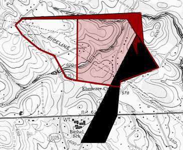
Important Title History for Lands at the Mouth of Gourdvine Branch
• Grant 5982 issued to Frederick Taylor (cleaver shaped tract in lower center): gray shaded area making up the blade of the cleaver passed through the hands of Richard and then Isaac Williams before being sold to Obediah Curlee and then to James Baucom., James Baucom sold to William Holly the western half lying west of Gourdvine containing 116 acres. Shaded in green, the northern most east-west line is identified as being above the “Meeting House Ford” and as has been verified, there is an ancient ford crossing the branch at the red star. Note that Edmond Davis Cemetery is nearby at which Location I believe once stood the old Gourdvine Baptist church. Wit: C. B. Curlee, William Mullis.
• Grant 5613 issued to Henry Marshall. Dated 15 Mar 1837 and as shaded in orange, Joseph Newsome sold a portion of the Henry Marshall tract adjoining the above grant 5982 to his son-in-law David Thomas (Deed 10-441). The westernmost line (in orange) adjoined “David Thomas lands” at the time of this 1837 conveyance. Chain bearer: William Holley, Irvin Lowtharpe.
• Grant 5484 issued to Joshua Williams. Near the top of the page, a large 350 acres tract shaded in gray passing underneath later conveyances identified in purple and yellow. The land passed through the hands of William Sehorn and then William Gurley who sold the western tip (shaded pink) to Headley Coburn. The remainder of the tract was sold to Joseph Newsome. Chainbearers: Michael Austin, West Lawhorn.
• Deeds V-295, and N-332. Two adjoining tracts underlying grant 5484 and illustrating a change in land bounds:
o (Yellow) Deed V-295, 19 Jan 1826, William (x) Barnes to Solomon Mullis, land adjoining the Gourdvine Branch. Wit: Daniel Smith.
o (Light Purple) Deed N-332, 14 Jan 1811, William Bennett of Kershaw SC to Thomas Griffin. Wit: Jacob Little, Mary Little.
• Deed N-330, 11 Nov 1801. (Dark Gray right facing arrow shape adjoining Richardson Creek) Job Swain of Anson to William Bennett of Martin County NC. Wit: Daniel Coburn, Thomas Griffin.
• Grant 150, Union County NC, ent. 14 Jan 1851, iss. 29 May 1851.(Shaded Red) Issued much later on top of prior grants causing an important legal battle reaching all the way to the Confederate States of America Secretary of War. Issued to DANIEL M. FESPERMAN, being 100 acres on Richardson Creek beginning at a stake on the south east side of said creek at the mouth of Gourdvine Branch and up the various courses of the branch 32 chains to the mouth of Haw Branch, then east one chain to a post oak Josiah Austin’s corner, then with his line north 82 east 12 chains to his other corner a the edge of the road, then north 65 east 9 chains to a stake on the bank of Richardson Creek, then up the various courses of saud creek to the beginning. Chainbearers: —-
• Deed T-191, Anson NC, 4 Apr 1821. (Shaded Light Blue against Richardson Creek) Benjamin Thomas to Ananias Thomas being 250 acres on Richardson Creek composed of several tracts granted to or purchased by Benjamin Thomas. Wit: Jesse Austin, Jesse Gurly.
22. Grant 4324, Anson NC, ent. —, iss. 4 Oct 1783. Issued to GIDEON GREEN, being 150 acres on the south side of Rocky River on both sides of Richardson Creek beginning at a red oak on the north west side of said creek and runs up the walnut tree branch north 30 west 110 poles to a hickory, then south 58 west 219 poles crossing of said creek to a hickory on the mouth of said creek, then south 32 east 110 poles to a stake, then north 58 east 219 poles crossing the said creek to the beginning. Chainbearers: Salathiel Clifton, Benj’n Thomas.
Deed H-214, Anson NC, 26 Oct 1785, rec. Jul 1786. Gideon (x) Green to Benjamin Thomas, being 150 acres on both sides of Richardson Creek. Wit: William Gurley, Charles Harrington.
23. Grant 5172, Anson NC, ent. 24 Oct 1793, iss.10 Jul 1797. Issued to MICHAEL AUSTIN, being 150 acres on the south side of Richardson Creek beginning at Salathiel Clifton’s corner white oak on the bank of said creek and runs with said line south 50 east 22 ch to his corner pine, then south 15 east 15 ch to a stake, then north 50 east 26 ch to a stake, then south 50 east 10 ch to a stake, then north 50 east 42 ch to a stake, then north 28 west 20 ch to a stake in Benjamin Thomas’ line, then with said line south 58 west 43 ch to his corner, then with his other line north 32 west 27 ch to his corner on the creek bank, then up the creek to the beginning. Chainbearers: Benjamin Thomas, David Thomas.
Deed L-12, Anson NC, 26 May 1798, reg. Oct 1805. Michael Austin to Benjamin Thomas now identifies as 100 acres with slightly different metes and bounds beginning at a stake, the fifth corner of sd. survey and runs south 50 east 10 chains to a stake, then north 50 east 42 chains to a stake, then north 28 west 20 chains to a stake in said Thomas’ line, then with said line south 48 west 43 chains to his corner, then a direct course to the first station. This is a subdivided tract being the eastern portion of grant 5172 to Michael Austin. Wit: Henry Henson (x), William Schore (Shehorn).
Deed N-331, Anson NC, 11 Nov 1801, reg. Jan 1811. Job A. Swain (planter) to William Bennett of Martin County (planter), being 50 acres and a subdivided western portion of Michael Austin’s grant 5172. Beginning on the south side of Richardson Creek at a stake Benjamin Thomas’ corner and runs north 32 west 27 ch to said creek Thomas’ corner, then with said creek to Clifton’s corner, then south 50 east 22 ch to a corner pine, then south 50 west 20 ch to a stake, then south 15 east 15 h to a stake, then north 15 east 26 ch to a stake in Benjamin Thomas’ beginning then with said Thomas’ line to the beginning. Wit: Daniel Coburn, Thomas Griffin.
Deed N-330, Anson NC, 14 Jan 1811, reg. Jul 1811. William Bennett of Kershaw County South Carolina to Thomas Griffin of Anson, being the same land, part of grant 5172 conveyed in Deed N-331. Wit: Jacob Little, Mary Little.
Deed W-313, Anson NC, 24 Nov 1826, reg. Thomas Griffin to Moses K. Hyams being 360 acres at the mouth of Gourdvine Branch. Wit: H. M Hyams, John Rushing. [note: Henry M. Hyams became a surveyor for Louisiana and later served as Lieutenant Governor of the State of Louisiana during the Civil War.]
Deed X-32, Anson NC, 19 May 1829, reg. Jul 1829. Moses Hyams of Anson to Samuel Hyams of the City of Charleston SC. For ten dollars, being 360 acres at the mouth of Gourdvine Creek. Also for five dollars he sold several slaves: Sambo about fifty and Grace about forty along with Tom 17, Richard 14 and Albert about 7 and Louisa about 3 years of age. Wit: William I. Alexander, Isaac Hyams. [note: Samuel is the father of Moses K. Hyams and brother of Kitty Hyams [Hyde who was Marie Antoinette’s maid of honor.]
24. Grant 7153, Anson NC, ent. 11 Jan 1836, iss. 24 Dec 1838. Issued to ANNANIAS THOMAS, being 30 acres adjoining his own lands on Richardson Creek beginning at a stake his old line in a small path one red oak pointers and runs north 35 west 2.50 to a white oak on the bank of Richardson Creek just below the mouth of a small branch Gurley’s upper corner, then south 39 east 22 ch to a red oak Gurley’s 1st corner of a 100 acre survey one pine and red oak pointer, then with the line south 32 west 31 ch to his corner hickory by a hickory and two dogwood pointers, then south 1 west 7.70 ch to a red oak in his old line, then with said line north 25 west 18 ch to a stake in his old line, then with said line north 50 east 24 ch to his corner stake, then with his other line north 28 west 20 ch to the beginning. Chainbearers: Ebenezer Thomas, John R. Thomas.
25. Grant 5838, Anson NC, ent. 12 Feb 1797, iss. 7 Dec 1804. Issued to BENJAMIN THOMAS, being 100 acres on the south side of Richardson Creek beginning at a post among three pines in his own line and runs south 25 east 45 ch to a post oak with a post oak and hickory pointer, then north 80 east 22.50 ch to a stake among three post oaks, then north 25 west 45 ch to and beyond Jacob Gurley’s corner to a pine in his old line, then with his lune south 80 west 22.50 ch to the beginning. Chainbearers: Annanias Thomas, Jacob Gurley.
Deed T-191, Anson NC, 4 Apr 1821, reg. Apr 1821. Benjamin Thomas to Ananias Thomas being 250 acres on Richardson Creek beginning at a hickory on the south side of said creek and runs south 32 east 110 poles to a state at the south corner of tract 150 acres granted to Michael Austin by his excellency Samuel Ashe in the year 1797 then said line south 50 east 10 ch to a stake at the beginning corner of a tract of 100 acres granted to Benjamin Thomas by his excellency J. Turner in the year 1806 and runs with his line south 25 east 45 ch to a post oak with a post oak and hickory pointers, then north 60 east 22.50 ch, then north 25 west 43 ch to a stake among 3 post oaks, then north 28 west to said Richardson Creek at Benjamin Thomas’ beginning corner at an old survey, then up the various courses of said creek to the beginning. Wit: Jesse Austin, Jesse Gurley.
26. Grant 6757, Anson NC, ent. 10 Apr 1827, sur. 28 Jul 1829, iss. 25 Nov 1829. Issued to MOSES K. HYAMS being 12 acres joining his own and Wm Barnes’ land on the waters of Gourdvine Creek beginning at a hickory stump in the edge of the road Barnes’ corner and runs with Barnes’ line north 65 east 24.75 ch to Barnes’ and Thomas’ corner state two post oaks, hickory and pine pointers, then with his own line north 50 west 10 ch to his corner stake three red oaks and dogwood pointers, then with his other line south 50 west 27 ch to a stake in Barnes’ line, then with the said line to the beginning. Chainbearers: Joseph Stewart, David Thomas.
27. Grant 6589, Anson NC, ent. 15 Jul 1823, iss. 14 Dec 1825. Issued to WILLIAM BARNES, being 218 acres adjoining Thomas Griffin and Annanias Thomas and his own land on both sides of the Gourdvine Creek beginning at a red oak in Griffin’s line, formerly his own line and runs west 30 ch to a pine two pines Hickory and post oak pointers, then north 45 west 15.50 ch to a bunch of dogwoods, then north 65 east 12 ch to a pine Griffin’s corner, then north 15 ch to a hickory one wild cherry tree pointers, then with Griffin’s other line north 56 east 40 ch crossing Gourdvine to a hickory, then north 52 west 10.90 to a sweet gum, then north 14 west 7.90 ch to a post oak, then north 82 east 12 ch to a hickory on the edge of the road, then north 65 east 24.75 ch to a stake in Thomas’ line two post oaks and pine pointers, then south 26 east 45 ch to a stake and three post oak pointers, then south 74 west 3.74 ch to a pine, then north 55 west 12.70 ch to a dead black oak, then south 65 west 20 ch to a red oak, then north 30 west 12 ch to Griffin’s corner stake, then with his line south 57 west 32 ch to a stake and three red oak pointers, then with his other line south 30 east 35 ch to the beginning. Chainbearers: Ransom Baucom, Thomas Barns.
28. Grant 5369, Anson NC, ent. 7 Jul 1796, iss. 7 Jun 1799. Issued to MICHAEL AUSTIN, being 200 acres on the Gourdvine Branch on the mouth of Buck Branch beginning at a white oak with two red oak pointers on the east bank of said branch at the mouth of the Buck Branch and runs North 57 east 32 ch to a red oak with two hickories and red oak pointers, then north 30 west 62 ch to a stake with two pines and black oak pointers, then south 57 west 32 ch crossing said branch to a stake, then then south 30 east 63 ch crossing said branch to the beginning. Chainbearers: Jacob Gurley, John Gurley.
Deed H2-117, Anson NC, 16 Sep 1800, reg. Apr 1801. Michael Austin to John Austin, being 200 acres, grant 5369 issued to Michael Austin. Test. Thomas (X) Hood, Jacob Austin.
Deed M-254, Anson NC, 3 Apr 1806, rec. Jan 1808. John Hocutt, planter of Anson to John Austin of Anson, being 200 acres on both sides of Gourdvine Creek beginning at the mouth of Buck Branch. Wit: Nathaniel (x) Williams, Elizabeth (x) Williams.
Deed O-128, Anson NC, 14 Jan 1812, reg. Apr 1812. Jas. Auld Esq. high sheriff to William Barnes by virtue of an execution against John Austin for the sum of 77 pounds which was recovered by William Barnes. Wit: D. Cuthbertson, Elias Preslar.
Deed O-187, Anson NC, 14 Jan 1808, reg. Jan 1812. Ingoe Dozer Cash to John Hocutt being 200 acres on the Gourdvine Creek conveyed from Michael Austin to John Austin and sold by the Sheriff to Ingoe D Cash. Wit: Martin Pickett, T. W. Bleaney.
29. Grant 5899, Anson NC, ent. 31 Jan 1804, iss. 8 Dec 1807. Issued to ISAAC WILLIAMS, being 150 acres on the Gourdvine Branch beginning at a pine by one pine and two post oaks Rich’d Lee’s corner on the east side of the Buck Branch and runs with his line south 85 west 8.50 ch to said Williams’ corner of the land he lives on, then with his lines north 18 west 15 ch to his beginning corner hickory, then with his line north 42 west 15 ch to a hickory standing in a branch, then with Austin’s line, then north 54 east 12.50 ch to a red oak his corner, then with his other line north 30 west 52 ch to a red oak in said line, then north 65 east 20 to a black oak, then south 55 east 12.50 ch to a pine, then a direct line to the beginning. Chainbearers: Benjamin Williams, William Williams.
30. Grant 6045, Anson NC, ent. 23 Feb 1811, iss. 14 Dec 1812. Issued to ISAAC WILLIAMS, being 165 acres adjoining Isaac Williams Senr beginning at his corner pine by a pine and post oak and runs north 75 east 88 poles to a stake by two pines and red oak in Thomas’ line, then north 88 east 18 poles to a stake by three post oaks, then north 30 east 12 poles to a stake, then north 50 east 80 poles to a stake by post oaks, then south 60 west 96 poles to a pine, then south 20 east 80 poles to a post oak, then south 34 west 130 poles to a stake in Isaac Williams’ line, then direct line to the beginning. Chainbearers: Henry Bass, John Parker.
31. Grant 5834, Anson NC, ent. 4 Jun 1797, iss. 5 Dec 1805. Issued to JACOB GURLEY, being 100 acres on both sides of Gourdvine Creek of Richardson at the mouth of Buck Branch beginning on the east side of the Buck Branch at a hickory by a hickory and black oak and runs north 42 west 15 ch to a hickory, then north 78 west 4.50 ch to a stake, then south 60 west 13.50 to Michael Austin’s corner white oak, then west 20 ch to a stake, then south 22 ch to a stake, then east 21.50 ch to a white oak, then north 85 east 30 ch to a stake, then to the beginning. Chainbearers: John Gurley, John Holland.
Deed L-195, Anson NC, 4 Mar 1805, reg. Jul 1806. Jacob Gurley to Isaac Williams Senr., being the same 100 acres on the east side of Buck Branch issued to Jacob Gurley via grant 5843. Wit: Willis Gurley, Rich’d Williams.
Deed V-92, Anson NC, 3 Apr 1822, rec. Apr 1825. James Baucom to Solomon Mullis, being 25 acres “on the Gourd Vine Branch the west side being part of a tract granted to Jacob Gurley conveyed to Isaac Williams Senr then to Obediah Curlee then to James Baucom”. Wit: Obediah Curlee.
32. Grant 5982, Anson NC, ent. 20 Jan 1797, sur. 21 Mar 1798, iss. 18 Dec 1811. Issued to FREDERICK TAYLOR being 300 acres on both sides of Gourdvine Branch beginning at Richard Lee’s corner post oak and runs with his line north west 49.25 chains to his corner white oak, then with his other line north 83 east 30 chains crossing said branch to a stake among three post oaks, then north 15 west 50 chains to a stake among three post oaks, then south 7 east 99 chains to a stake among three red oaks, then to the beginning. Chainbearers: Richard Lee, Azeriah Coburn.
Deed O-187, Anson NC, 6 Aug 1808. John Jennings, Sheriff, to Richard Williams for debt to Solomon Stegall. Wit: John Sturdivant, Meredith Johnson.
Deed S-274, Anson NC, 26 Jan 1818. Richard Williams to Willis Williams, being the southern end of grant 5982. Wit: Isaac Williams, Jacob Little.
Deed T-304, Anson NC, Nov 1819. Isaac Williams to Obediah Curlee. Wit: Amos Griffin, Jacob Thomas.
Deed T-313, Anson NC, 2 Jan 1821, Obediah Curlee to James Baucom, being the upper end of the tract. Wit: Lewis Baucom, Ransom Baucom.
V-415 Anson NC, 24 Sep 1821, James Baucom to William Holly being all of the northern half of the 300 acre tract lying west of Gourdvine containing 116 acres. In this deed the northern most east-west line is identified as being above the “Meeting House Ford.” Wit: C. B. Curlee, William Mullis.
33. Grant 5613, Anson NC, ent. 15 Jul 1799, sur. 30 Apr 1801, iss. 11 Aug 1803. Issued to HENRY MARSHALL, being 300 acres beginning at a hickory Richard Lee’s old beginning [corner] at the side of the Green Pond then south 70 west 45 chains to a stake, then with his line south 30 east13 chains to a stake, then south 6.25 to his corner pine, then west 23.5 chains to a stake, then south 14 chains to a stake, then north 33 west 35 chains reverse on his line to a hickory by two red oaks and two pines, then south 20 west 4.75 to Semor Cobb’s white oak corner by three pines, then north 17 west 47.75 chains to a stake by three white oaks, then north 86 east 25 chains to a pine by one pine and two white oaks, then direct to the beginning. Chainbearers: John Cobb, John Holland.
Deed 10-441, Anson NC, 15 Mar 1837, reg. Apr 1842. Joseph Newsome to David Thomas, being 100 acres cut out from the western side of grant 5613 and now adjoins lands of Lowtharpe and David Thomas. Wit: William Holley, Irvin Lowtharpe.
34. Grant 5316, Anson NC, ent. 19 Apr 1796, sur. 19 Apr 1796, iss. 9 Mar 1799. Issued to RICHARD LEE, being 150 acres on Richardson Creek, beginning at a post oak by two pines and one post oak and runs north 8 west 50 chains to a white oak by two hickories and black gum, then north 82 east 30 chains to a hickory by two red oaks ad two pine pointers, then south 33 east 35 chains to his corner pine of a fifty acre survey, then a direct course to the beginning. Chainbearers: Jonathan Polk, Solomon Lee.
Deed S-447, Anson NC, 30 Oct 1819, rec. Jan 1820. Richard Lee, to Joseph Newsom, being one of six tracts totaling 920 acres. Wit: Wm. Hammond, J. Holmes.
Deed 10-441, Anson NC, 15 Mar 1837, rec. Apr 1842. Joseph Newsom to David Thomas. Wit: William Holley, Irvin Lowthorpe.
35. Grant 4403, Anson NC, ent. 15 May 1779, sur. 16 Jun 1779, iss. 14 Oct 1783. Issued to GEORGE BREWER, being 50 acres on the south west side of Pee Dee on the both sides of the Big Branch of Gourdvine Creek beginning at a pine standing near the said branch and running south 86 poles to a post oak, then west 94 poles to a pine, then north 86 poles crossing the said branch to the beginning. Chainbearers: John Taylor, Geo. Brewer.
Deed F-43, Anson NC, 3 Nov 1790, reg. Jan 1799. George (x) Brewer to Richard Lee of Edgecombe County NC being 50 acres on both sides of the Big Branch. Wit: Bryan Lee, Labeth (x) Brewer.
36. Grant 5045, Anson NC, ent. 22 Aug 1784, iss. 9 Jul 1794. Issued to RICHARD LEE, being 100 acres beginning at a hickory near the drains of the Gourdvine Branch of Richardson Creek and runs south 20 east 90 poles to a post oak, then south 70 west 180 poles to a stake, then north 20 west 90 poles, then north 70 east 180 poles to the beginning. Chainbearers: James Brown, Bryan Lee.
37. Grant 6939, Anson NC, ent. 9 Jul 1833, iss. 29 Nov 1834. Issued to BENGAMIN R. BRASWELL, being 267 acres joining Joseph Newsom, John Grace, and Edward Dees on the flag fork, beginning at a stake one dogwood Spanish oak and red oak pointers and runs south 5 west 7.25 ch to a post oak, then west 4 ch to a post oak, then south 5 west 30 to a stake in Newsom’s line, then with said line east 55 ch,70 to a black jack in Dees’ line, then with said line north 10 east 49.40 to Grace’s corner one hickory pine and red oak pointers, then with his line west 21 ch to a stake three pines and post oak pointers, then north 18 west 22 to a stake, then south 72 west 5.75 ch to a hickory, then south 20 20 east 22.50 ch to a stake by a red oak, then south 70 west 33.50 ch to the beginning. Chainbearers: Francis Lowthorp, Green Deese.
38. Grant 5499, Anson NC, ent. 27 Dec 1798, sur. 28 Apr 1800, iss. 14 Nov 1800. Issued to RICHARD LEE, being 250 acres on the east side of Gourdvine Creek beginning at his, Bryant Lee’s and Henry Marshall’s corner black oak and runs east 20 chains, then south 27.3 chains, then east 5 chains, the south 15 chains to a post oak, then south 83 east 50 chains to a pine two post oaks, then north 56.3 chains to a hickory, then west 68.5 chains to said Lee’s line, then along said line to the beginning. Chainbearers: John Cobb, Rich. Lee.
Deed S-447, Anson NC, 30 Oct 1819, rec. Jan 1820. Richard Lee, to Joseph Newsom, being one of six tracts totaling 920 acres. Wit: Wm. Hammond, J. Holmes.
Deed Z-583, Anson NC, Joseph Newsom to Riley Griffin, being 25 acres.
39. Grant 5553, Anson NC, ent. 17 Jan 1798, 3 May 1798, iss. 8 Dec 1802. Issued to RICHARD LEE being 75 acres on Gourdvine Creek beginning on Bryant Lee’s corner red oak by two red oaks and pine and runs north 35 east 22 chains to a pine, then west to and with Richard Lee’s line 40 chains to his corner pine, then south 44 west 22.5 chains to Bryant Lee’s corner stake, then with said line to the beginning. Chainbearers: Jonathan Polk, Briant Lee.
40. Grant 5361, Anson NC, ent. 14 Nov 1795, sur. —, iss. 26 Nov 1799. Issued to HENRY MARSHALL, being 50 acres beginning at a black oak Bryant Lee’s beginning corner of two surveys and runs on said Lee’s line north 25 chains to a black oak Richard Lee’s and Bryant Lee’s corner by two black oaks, then east 30 chains to a stake, then south 25 chains to a stake, then a direct course to the beginning. Chainbearers: Wm. H. Davidson, Briant Lee.
41. Grant 4309, Anson NC, ent. 05 Oct 1778, sur. 15 Jun 1779, iss. 24 Oct 1782. Issued to GEORGE BREWER, being 100 acres on both sides of the Gourdvine Branch “on the old Indian path including his improvement” beginning at red oak near his little field and running west 127 poles to a stake between two hickories and black oak, and hickory, then south 127 poles to a stake between 2 hickories and black oak, then east 127 poles crossing the said branch to a stake, then north 127 pole crossing the said branch to the beginning. Chainbearers: George Brewer, Mark Allen.
Deed H2-216, Anson NC, 3 Nov 1790, 3 Nov 1790. George Brewer of Anson County to Bryan Lee of Johnston County NC being 100 acres beginning at the Little Field [believe this is what’s referred to as Richard Little’s shop field] Wit: Richard Lee, Lisbeth (x) Brewer.
42. Grant 5002, Anson NC, ent. 17 Jul 1791, sur. —, iss. 27 Nov 1792. Issued to BRYAN LEE, being 300 acres beginning at a red oak his old beginning in the east side of the Gourdvine and runs north 100 poles to a pine and oak, then west 180 poles to a stake and three pines, then south 327 poles to a stake, then east 180 poles to a stake, then north 100 poles to the said Lee’s fourth corner, then west 127 poles to his third corner, then north 127 poles to a hic and 2 red oaks to his and Lee’s old corner, then crossing the creek 127 poles to the beginning. Chainbearers: George Brewer, Jonathan Polk.
Deed P-188, Anson NC, 15 Mar 1813, reg. Jan 1818. Richard Lee to Neil McGugan, being 300 acres made of two tracts being grants 4403 and 5002 being land granted to Bryan Lee and later conveyed by Bryan Lee to Willis Collins and by Willis Collins to Reuben Williams and by him to Richard Lee. Wit: Jacob Little, Mary Little.
Deed R-132, Anson NC, 13 Dec 1814, rec. Jan 1816. Neil McGugan to John Cochran. Wit: Nathaniel Coker, Joseph Delock.
43. Grant 5621, Anson NC, ent. 8 Nov 1794, 8 Dec 1798, iss. 23 Sep 1801. Issued to JOHN WRIGHT JR., being 150 acres beginning at two dogwoods Bryant Lee’s corner by two black oaks and runs on said line north 50 chains to a stake in said line then east 30 chains to a stake, then south 50 chains to a stake, then to the beginning. Chainbearers: Richard Lee, Jonathan Polk.
44. Grant 7161, Anson NC, ent. 11 Oct 1836, sur/ 30 Aug 1837, iss. 26 Jan 1839. Issued to ROBERT BRASWELL, being 100 acres adjoining Joseph Newsom and Patrick Little’s lands on the waters of Gourdvine Creek beginning at a stake three black jacks in Newsom’s and Little’s line and runs with Newsom’s line north 82 west 46 chains to his corner post oak two post oaks and pine, then with his other line south 1 west 41.5 chains to a red oak, then east 3.5 chains to Little’s corner stake two black jacks and post oak, then north 30 east with his other line 12.5 chains to a stake, then south 80 east 23 chains to his other corner stake, then with Little’s other line north 25 east 31.70 chains to the beginning. Chainbearers: Patrick Little, Coleman Lee.
45. Grant 4529, Anson NC, ent. —, iss.14 Oct 1783. Issued to GIDEON GREEN,, being 50 acres on the south side of Richardson Creek beginning at a white oak standing on the bank of said creek and runs south 48 west 86 poles to a hickory standing on the bank of said creek, then down the various courses of the creek to the beginning. Chainbearers: Salathiel Clifton, Benj’n Thomas.
Deed C2-484, Anson NC, 12 Sep 1787, reg. Apr 1791. Gideon Green of Montgomery County to Jacob Gurley, planter of the same. Wit: Robin Williams, James Gurley.
46. Grant 5462, Anson NC, ent. —, iss. 18 De 11799. Issued to JACOB GURLEY, being 125 acres on Richardson Creek beginning at a pine stump the corner of his old survey with a hickory and two red oak pointers and runs south 20 east 30 ch to a post oak with a white oak and two pine pointers, then north 37 east 30 ch to a stake with two pines and red oak pointers, then north 4 east 45 ch to the creek to a pine, then up the creek 3 ch to a white oak the corner of his old survey, then with his old survey south 48 west 21.50 ch to a stake in his old line, then to the beginning. Chainbearers: ————
47. Grant 5451, Anson NC, ent. 16 Oct 1794, iss. 18 Dec 1799. Issued to JAMES AUSTIN, being 100 acres on both sides of Little Watery Branch beginning at a red oak with a red oak, post oak and pine and runs north 20 west 32.5 chains a red oak Jacob Gurley’s line, then north 70 east 31 chains to a post oak, then south 20 east 32.5 chains to a pine with two hickories and black oak, then south 70 west 31 chains to the beginning. Chainbearers: Richmond Crosswell, John Gurley.
48. Grant 0661, Anson NC, ent. 14 Jan 1819, iss. —. File numbers beginning with zero indicate that a grant was entered but never finalized. Something happened along the way and the grant was never officially issued. Shaded in RED below, grant 0661 was entered by Jacob Gurley and was never issued. It being 100 acres beginning at a red oak Austin’s corner on his line.
49. Grant 5249, Anson NC, ent. 23 Feb 1797, iss. 9 Mar 1799. Issued to JACOB GURLEY, being 100 acres on Little Watery Branch and beginning at a red oak by two pines in or near his own line and runs south 31 west 30 ch to a hickory, then south 8.50 ch to Benjamin Thomas’ line and with it south 30 east 8 ch, then north 88 east 32 ch to a black jack by four black jack pointers, then north 12 east 30 ch supposed to be in his own line to the beginning. Chainbearers: James Gurley, (Ananias) Elias Thomas.
50. Grant 6564, Anson NC, ent. 17 Jan 1822, iss. 24 Nov 1824. Issued to WILLIAM GURLEY being 50 acres adjoining Ananias Thomas’ and his own lands beginning at a pine by a pine in his own line and runs south 88 west 4.20 ch to a stake Thomas’ corner two post oaks, then north 25 west 34.50 ch to Gurley’s corner three post oaks, then north 88 east 32 ch to a stake in his own line, then with said line south 30 west 34 ch to his corner stake two red oaks and pine, then with his other line to the beginning. Chainbearers: Jesse Gurley, Cuthbertson Gurley.
51. Grant 5463, Anson NC, ent. —, iss. 18 Dec 1799. Issued to JACOB GURLEY, being 200 acres on the Little Watery Branch beginning at a hickory with a dogwood and red oak pointers and runs north 60 west 40 ch to a stake with pine and two black oak pointers, then north 30 east 50 ch to a stake among three pines, then south 60 east 40 ch to a stake, then south 30 west 50 ch to the beginning. Chainbearers: Michael Austin, Tom Griffin.
52. Grant 5797, Anson NC, ent. 18 Apr 1796, iss. 12 Nov 1804. Issued to ISHAM GURLEY, assignee of MICHAEL AUSTIN (JOHN LAHORN), being 200 acres on the flag fork of Water Branch beginning at a post oak by two post oak pointers and runs east 11.50 ch to a stake near Austin’s line, then south 28 east 4.50 ch to Austin’s corner post oak, then south 28 west 37.80 ch to a stake, then west 43 ch to a stake, north 37 ch to a stake, then east to the beginning. Chainbearers: James Gurley, John Lawhorn.
Deed L-221, Anson NC, 25 Nov 1805, reg. Oct 1806. John Hocutt to Nathaniel Williams, being the whole of a tract of land that the said Hocutt bought of Isham Gurley. Test. Bryan Vann, Willis Gurley.
Deed Q-227, Anson NC, 10 Mar 1815, reg. Jul 1817. James Allen to Frederick Staton, being 300 acres originally issued to Michael Austin via Grant 5797. Wit: W. Crittendon, Elijah Cockborn.
53. Grant 6136, Anson NC, ent. 15 Mar 1814, iss. 30 Sep 1814. Issued to ABSOLUM STEGALL, being 300 acres on Watery Branch, beginning at a post oak by three pines Hobbs’ corner and runs with his line south 10 east 56 poles to Gurley’s line, then with his line north 70 west 36 poles to his corner by a pine and white oak, then south 20 west 280 poles to a red oak by three pines, then north seventy west 116 poles to a stake, then north 15 west 28 poles to a pine, then north 275 poles to a stake, north 80 east 200 poles to a stake, then south 10 west 58 poles, then to the beginning. Chainbearers: Willie Austin, Charles Austin.
Deed T-288, Anson NC, 17 Nov 1817, reg. Jul 1821. Absolum Stegall to John Beasley, being 225 acres it being part of a tract to the sd. Absolum Stegall by his Excellency William Hawkings in the year 1810, on the Watery Branch beginning at a post oak by three pines Beasley’s corner and runs with his line south 10 east 56 poles to Gurley’s line, then with his line south 20 west 280 poles to a red oak by three pines, then north 70 west 160 poles to a stake, then north 16 west 28 poles to a pine, then north 275 poles to a stake, then north 80 east 200 poles to a stake, then south 10 west 58 poles to the beginning. Wit: Willie Austin, Charles Austin.
Deed W-83, Anson NC, 13 Apr 1827. Absolom Myers Esq. High Sheriff to Edmond Willoughby from an execution arising out of Montgomery County against John Beasley which was recovered by Ephraim Newsome and Robert Traywick. Being three tracts making up John Beasley’s grant 6410, Absolum Steagall’s grant 6166, and Josiah Baucom’s grant 5957.
54. Grant 6410, Anson NC, ent. 17 Dec 1818, iss. 20 Mar 1820. Issued to JOHN BEASLEY, being 118 acres adjoining his own land on Little Watery Branch beginning at a stake one Spanish oak and dead pine pointers James Austin’s corner and runs with said Austin’s line south 28 west 33 ch crossing the Little Watery Branch to a stake in or near his own line of his 300 acre survey, then north 75 east 39.50 ch to a stake in his own line of his other survey, then with said line north 10 east 9 ch to a post oak by a pine his corner, then with his other line east 14.50 to a Spanish oak, then north 5 east 5.70 to a stake, then east .90 to a stake by 3 post oaks, then north 7 ch to a stake by two post oaks Barber’s corner, then with Barber’s line north 64 west 28 ch to a stake, then a direct course to the beginning. Chainbearers: Bryant Austin, Henry Tolson.
Deed W-83, Anson NC, 13 Apr 1827. Absolom Myers Esq. High Sheriff to Edmond Willoughby from an execution arising out of Montgomery County against John Beasley which was recovered by Ephraim Newsome and Robert Traywick. Being three tracts making up John Beasley’s grant 6410, Absolum Steagall’s grant 6166, and Josiah Baucom’s grant 5957.
55. Grant 5171, Anson NC, ent. 24 Oct 1793, iss. 10 Jul 1797. Issued to DRURY AUSTIN, being 150 acres on the south side of Richardson Creek and on both sides of the Watery Branch beginning at a post oak on the bank of Richardson Creek below the mouth of the Watery Branch and runs south 60 east 30.50 ch to a stake in Samuel Bond’s line, then with said line south 7 ch to a pine, then west 75 links to his corner post oak, then with his other line south nine ch to a pine then south 14 west 15 ch to a stake, then north 60 west 42 ch crossing the Watery Branch to a stake, then north 30 east 29 ch to the beginning. Chainbearers: Michael Austin, West Lawhorn.
Deed L-257, Anson NC, 15 May 1804, reg. Oct 1806. Drury Austin of Mecklenburg NC to Nathan Morris of Anson, being 100 acres originally issued to Drury Austin via Grant 5171. Wit: John Curlee, Milly (x) Austin.
Deed U-243, Anson NC, 9 Oct 1822, reg. Jan 1823. Andrew Polk late Sheriff and Noah Barber of the other part, a certain piece of property supposed to be Nathan Morris’ 99 ¾ acres. Wit: W. Hammond, Daniel Phelan.
Deed V-431, Anson NC, 15 Dec 1824, reg. Jul 1826. (Tract 1) Noah Barber to Wyatt Nance being 100 acres also another tract of 16 acres. Wit: John Edwards, John Nance.
56. Grant 5957, Anson NC, ent. 13 Nov 1807, iss. 17 Oct 1809. (a large checkerboarded tract as seen below) Issued to JOSIAH BAUCOM, being 400 acres on both sides of the Pine Log beginning at a red oak by a hickory and two pines Edwards’ corner, and runs north 35 ch to post oak Bond’s corner, and then north 40 east 14 ch to an ash on the bank of said Pine Log, then down the various courses of said branch to the mouth of Cedar Branch, then up the various courses of of the said branch to a stake on the west side of the Ridge Path by a red oak and two pines, then north 27 west 21 ch to a stake, then north 40 west 11.50 to a red oak by two red oaks Griffin’s corner, then west 30 ch to post oak by a pine, then south 10 west 30 ch to a stake by three pines, then south 73 13.30 ch to a stake by a pine and post oak near Beasley’s line, then with his line south 70 8 east 15 ch to Gurley’s line, then with his line south 70 east24 ch to his corner stake by three pines, then with his other line south 20 west 25 ch to a stake in Gurley’s line, then south 43.23 ch to a pine Austin’s corner by three pines, then with his line north 30 east 44 ch to a stake by three red oaks, then with his other line south seventy east 31 ch to a stake his corner, then a direct line to the beginning. Chainbearers: George Hobbs, John Edwards.
Deed N-267, Anson NC, 30 Apr 1808, reg. Oct 1810. Joshua Baucom to George Hobbs, being 200 acres on Helms Branch of Watery Branch beginning at a stake by two pines and red oak at the at the end of the dividing line between Benjamin Oneal and the said Hobbs and runs north 27 west 21 ch to a stake, then north 40 west 11.50 ch to a red oak by two red oaks Griffin corner, then west 30 ch to a post oak by a pine and hickory, then south 10 ch , west 30 ch by three pines, then south 73.13 ch to a stake by a post oak and Spanish oak near the said John Beasley’s fence, then south 8 east 15 ch to Gurley’s line, then with his other line south 20 west 25 ch to a stake in said Gurley’s line, then south 43, east 20 to two pines Austin’s corner, then north 7 east 67.51 ch to then beginning. Wit: Isaac (X) Wilkinson, Peter McIntyre.
Deed S-337, Anson NC, 20 Jan 1808, reg. 1819. (Shaded GRAY, being the checkerboarded western half of tract blow) George Hobbs to John Beasley, being 200 acres on Helms Branch of Watery Branch beginning at a stake by two pines and red oak at the at the end of the dividing line between Benjamin Oneale and the said Hobbs and runs north 27 west 21 ch to a stake, then north 40 west 11.50 ch to a red oak by two red oaks Griffin corner, then west 30 ch to a post oak by a pine and hickory, then south 10 ch , west 30 ch by three pines, then south 73.13 ch to a stake by a post oak and Spanish oak near the said John Beasley’s fence, then south 8 east 15 ch to Gurley’s line, then with his other line south 20 west 25 ch to a stake in said Gurley’s line, then south 43, east 20 to two pines Austin’s corner, then north 7 east 67.51 ch to then beginning. Wit: Ric’d Moore, Asa (x) Baucom.
Deed N-267, Anson NC, 30 Apr 1808, reg. Oct 1810. Josiah Baucom to George Hobbs, being 200 acres the western half of the tract. Wit: Isaac (x) Wilkinson, Peter McIntyre.
Deed S-337, Anson NC, 20 Jan 1808, reg. George Hobbs to John Beasely. Wit: Re’d Moore, Asa Baucom.
Deed W-83, Anson NC, 13 Apr 1827. Absolom Myers Esq. High Sheriff to Edmond Willoughby from an execution arising out of Montgomery County against John Beasley which was recovered by Ephraim Newsome and Robert Traywick. Being three tracts making up John Beasley’s grant 6410, Absolum Steagall’s grant 6166, and Josiah Baucom’s grant 5957.
Deed X-147, Anson NC, 5 Mar 1810, reg. Jan 1830. Josiah (x) Baucom to Benjamin Oneal. Being the BLUE shaded and checkerboarded northeastern portion of Josiah Baucom’s grant 5957. Wit: Wm. Curlee, John (x) Begs (Beggs).
57. Grant 5327, Anson NC, ent. 20 Jan 1797, iss, 9 Mar 1799. Issued to WILLIAM GURLEY, being 250 acres on the Watery Branch beginning at a red oak with a post oak and two pines on the west side of said branch and runs north 20 est 63.30 ch crossing the said branch to a stake two pines and white oak, then south 70 east 39 ch to a stake, then south 20 west 63.50 ch to a stake, then north 70 west 39 ch to the beginning. Wit: Michael Austin, Drury Austin.
Deed W-140, Anson NC, __ Dec 1821, reg. Jan 1828. (Shaded YELLOW below, being the northern half of 5327) Nathan Pool of Kentucky to Lydia Pool releases quit claim unto the said Lydia Poole to the right and title claims unto the land belonging to the estate of William Gurley Sen. Dec’d [bequeathed by will to Saunders Pool]. Wit: Jacob Little, Hosea Little.
Deed T-121, Anson NC, 23 Nov 1816, reg. Oct 1820. (Shaded GRAY below, being the southern half of 5327) William Gurley of Mongtomery County NC and John Gurley of Montgomery County NC to Jacob Thomas of Anson NC, being 172 acres of the tract of land bequeathed to James Gurley by his father William Gurley. Wit: Benj. Thomas, Willis Gurley.

Historical Topographic Map Collection
58. Grant 6626, Anson NC, ent. 13 Oct 1824, iss. 14 Dec 1826. Issued to JAMES HOLMES, being 100 acres joining David Thomas and William Gurley on the Big Watery Branch beginning at a stake in John Grace’s line and or near Cockburn’s line one pine post oak and dogwood pointers and runs north 27 east 31.80 ch to a pine in Thomas’ line, then with Thomas’ and Beasley’s lines north seventy west 49.25 ch to a stake in Staton’s line, then then with said line south 15 west 11 ch to Grace’s corner stake formerly Thomas’ corner, then with his line south 45 east 49 ch to the beginning. Chainbearers: William Gurley, Cullen Braswell.
59. Grant 6791, Anson NC, ent. 24 Mar 1829, iss. 16 Nov 1830. Issued to JAMES HOLMES, being 12 acres joining James Allen and John Grace on the Flag Fork Branch beginning at a pine Allen’s corner in Grace’s line and runs with Allen’s line south 20 east 16.50 ch to his corner stake in Cockburn’s line, then with said line north 82 west 15 ch to a stake in Grace’s line, then with his line to the beginning. Chainbearers: Asa Hyatt, Cullen Braswell.
60. Grant 5092, Anson NC, ent. 5 Mar 1794, 8 Dec 1794. Issued to DAVID THOMAS, being 100 acres on the flag fork of Watery Branch of Richardson Creek and beginning at a red oak on the bank of said branch an runs south 45 east 33 ch to post oak with two pine pointers, then south 45 west 31 ch to a pine with a post oak and pine pointers, then north 45 west 33 ch to a stake with two post oaks and pine pointers, then to the beginning. Chainbearers: John Pool, William Pool.
Deed O-65, Anson NC, 8 Apr 1811, reg. Jul 1811. (Tract 1) James S. Auld, Sheriff to James Holmes Senr. by virtue of execution against William Keneday, being 100 acres issued to David Thomas via Grant 5092. Wit: Robert Coman, P. Boggan Junr.
Deed V-144, Anson NC, 4 Jan 1825, reg. Jul 1825. (Tract 1) James Holmes of the County of Perry and State of Alabama to John Grace of Anson, being in whole 400 acres. The first tract lying on the Flag Fork of the Watery Branch and runs south 45 east 33 ch to a post oak with two pine pointers, then south 45 south 45 west 31 to a pine with a pine and post oak pointers, then north 45 west 33 ch to a stake, then with two post oaks and pine pointers, then north 45 west 33 then to the beginning containing 100 acres granted to David Thomas 8 Dec 1794. Wit: James Lake
61. Grant 5778, Anson NC, ent. 12 Feb 1797, iss. 26 Nov 1805. Issued to DAVID THOMAS, being 100 acres on the Flag Fork of Watery Branch and beginning at a red oak the beginning corner of his old survey on the bank of said branch and runs north 45 west 31.50 ch to a stake among three pines, then south 45 west 32 to a stake among three red oaks, then south 45 west 31.50 chg to the corner of his old survey, then with the last line of said survey to the beginning. Chainbearers: Michael Austin, Drury Austin.
Deed V-144, Anson NC, 4 Jan 1825, reg. Jul 1825. (Tract 3) James Holmes of the County of Perry and State of Alabama to John Grace of Anson, being 100 acres granted to David Thomas 26 Nov 1805 and beginning at the red oak corner of the first tract. Wit: James Lake.
62. Grant 6011, Anson NC, ent. 18 Jan 1804, iss. 6 Jul 1812. Issued to ELIJAH WILLIAMS, being 300 acres on the flat fork of Little Watery Branch beginning at a red oak by three black and two post oaks, David Thomas’ third corner of his one hundred acres and runs with his line reverse north 45 east 33.30 ch to a stake among three dead pines said Thomas’ corner, then north 15 east 15.60 ch to a red oak, then north 25 west 1 to Nathaniel Williams’ line, then with his line south 28 west? 43 ch to his corner, then along his line north 15.50 ch to Jacob Gurley’s line, then with his line south 30 west 18 ch to his beginning hickory, then with his other line north 60 west 17.50 ch crossing the Little Watery Branch to a stake in said line, then south 63 west 28.60 ch to a pine by one post oak, then south 20 east 20 ch to a post oak among three pines, then south 68 east 53 ch to or near David Thomas’ line, then direct to beginning. Chainbearers: Isaac and William Williams.
Deed Q-228, Anson NC, 3 May 1816, reg. Jul 1817. Isaac Williams to Frederick Staton, being 150 acres, the southeast portion of 300 acres issued to Elijah Williams via Grant 6011. Wit: Henry Bass.
63. Grant 6046, Anson NC, ent. 23 Feb 1811, iss. 14 Dec 1812. Issued to WILLIS WILLIAMS, being 235 acres beginning at Isaac Williams Senr beginning of 150 acre tract ad runs his line north 10 west 50 poles to stake on said line, then north 34 east 130 poles to Isaac Williams corner post oak, then south 68 east 206 poles to a stake two black jacks and pine, then south 13 west 176 poles to a stake, then direct line to the beginning. Chainbearers: Henry Bass, John Parker.
Deed T-313, Anson NC, 26 Nov 1819, reg. Oct 1821. (Tract 1) Willis Williams to Obediah Curlee, being 235 acres originally issued to Willis Williams via Grant 6046. Wit: Amos (x) Griffin, Jacob Thomas.
Deed T-313, Anson NC, 26 Nov 1819, reg. Oct 1821. (Tract 2) Willis Williams to Obediah Curlee, being 200 acres on Gourdvine Creek beginning at Richard Lee’s corner post oak and runs with his line north 7 east 59.25 ch to his corner white oak, then with his other line north 83 east to the said Gourdvine Branch, then down the various courses of said branch to Richard Williams line, then with his line south 83 west to his corner post oak saplin, then still with his line south 7 east 99 ch to a stake among three red oaks, then to the beginning as was conveyed from Richard Williams to Willis Williams by deed bearing date 26 Jan 1818. Wit: Amos (x) Griffin, Jacob Thomas.
Deed T-313, Anson NC, Obediah Curlee to James Baucom, being 216 acres on both sides of Gourdvine Creek beginning at a white oak then with his line other line north 83 east 30 ch crossing said branch to a stake among three post oaks, then north 15 west 50 ch to a stake among three post oaks, then north 15 west 50 ch to a stake among three post oaks, then south 70 east 50 ch to a stake, then to the beginning. Wit: Lewis Baucom, Ransom Baucom.
64. Grant 5595, Anson NC, ent. 12 Dec 1800, iss. 11 Aug 1803. Issued to DAVID THOMAS, being 200 acres beginning at Hood’s corner pine in his own line and runs with said Hood’s line south 25 west 76 poles to his corner post oak, then north 75 west 23 poles to Brown’s corner hickory, then with or near said line south 10 west 118 poles to a stake, then west 82 poles Jacob Gurley’s corner stake then with his line north 37 east 160 poles to his corner stake by two pines and post oak then with his other line north 42 west 116 to the beginning corner red oak, then with his other line south 65 west (or east?) 100 poles to a stake, then north 45 west 139 poles to a stake, then north 45 east 168 poles to a stake, then south 45 east to and with his own line to the beginning. Chainbearers: Jacob Gurley, Isham Gurley.
Deed O-65, Anson NC, 8 Apr 1811, reg. Jul 1811. (Tract 2) James S. Auld, Sheriff to James Holmes Senr. by virtue of execution against William Kenneday, being 200 acres issued to David Thomas via Grant 5595. Wit: Robert Coman, P. Boggan Junr.
Deed V-144, Anson NC, 4 Jan 1825, reg. Jul 1825. (Tract 2) James Holmes of the County of Perry and State of Alabama to John Grace of Anson, being 200 acres granted to David Thomas 11 Aug 1803. Wit: James Lake.
65. Grant 6041, Anson NC, ent. 18 Apr 1810, iss. 14 Dec 1812. Issued to JACOB GURLEY, being 150 acres on the Flag Branch near the Green Pond beginning at a red oak by a white oak and runs west 178 poles to a post oak, then south 37 east 100 poles to a stake in or near Lee’s line, then north 60 poles, then east 15 poles to a hickory, then south 48 east 92 poles to a hickory, then north 33 east 134 poles to a stake, then to the beginning. Chainbearers: Jesse Brooks, Elijah Williams.
Deed Y-447, Anson NC, 12 Dec 1826, reg. Oct 1833. Jesse Gurley and William Gurley Executors of Jacob Gurley dec’d to David Gurley, being the same land as was issued to Jacob Gurley via Grant 6041. Wit: William Cuth. Gurley, B. A, Austin.
Deed Y-443, Anson NC, 30 Jan 1832, reg. Oct 1833. David Gurley to Cullen Braswell, being the same land as was issued to Jacob Gurley via Grant 6041. Wit: Bryant Braswell, A Tye.
66. Grant 5068, Anson NC, ent. 2 Aug 1784, iss. 9 Jul 1794. Issued to JOSEPH GREEN, being 300 acres beginning at a hickory on the west side of the flag ford of the Watery Branch of Richardson’s Creek and runs south 80 east 160 poles crossing said Flagg Fork to a white oak, then south 10 west 330 poles to a stake near Cribb’s Creek, then north 80 west 160 poles to a stake, hen north ten east 330 poles to the beginning. Chainbearers: Bryan Lee, Richard Lee.
Deed O-463, Anson NC, 22 Nov 1809, reg. Jan 1814. Beverly Daniel Esq. Marshall for District of North Carolina of the one part to Ingoe D. Cash, being 300 acres on which said land the direct tax imposed thereon authorized by congress the 14th Jul 1798 was not paid on the sum of one dollar and sixty nine cents being the amount of tax due thereon the said Joseph Picket collector …at public auction. This being the same 300 acres originally issued to Joseph Green via Grant 5068. Wit: Wm. R. Pickett, Laurence Moore.
Deed X-148, Anson NC, 13 Jan 1823, reg. 1830. Ingoe D. Cash to Asa Traywick, being 300 acres formerly the property of Joseph Green. Wit: T. Godfrey, William Hirt
Deed Y-199, Anson NC, 17 Mar 1832, reg. Jul 1832. Robert Cochran to Edmund Dees, being the same 300 acres originally issued to Joseph Green via Grant 5068. Wit: Allen Carpenter, Harvey Ingram.
Deed Y-266, Anson NC, 24 Sep 1829, reg. Jul 1833. Asa Traywick to Robert Cochran, being the same 300 acres originally issued to Joseph Green via Grant 5068. Wit: Cullen Braswell, Eli Cochran.
67. Grant 6056, Anson NC, ent. 1 Jul 1811, iss. 18 Dec 1812. [not shown on the Map as it’s not yet located. I believe this tract will connect below tract # 68] Issued to THOMAS HOOD, being 300 acres adjoining William Travis and Brown’s lands, beginning at a post oak Brown’s corner and runs with his line south 8(0)west 330 poles to a stake in or near Travis’ line, then south 65 east 140 poles to a stake, then north 15 east 304 poles to a stake, then north 66 west 166 poles to a white oak McInvale’s corner, then north 24 east 40 poles to a stake, then to the beginning. Chainbearers: Jesse Lacy, James Allen.
Deed U-200, Anson NC, 5 Jan 1814, reg. Jan 1823. Thomas Hood of Wake County to Asa Hyatt of Anson, being 300 acres joining Wm Travis and Brown lands issued to said Thomas Hood via Grant 6056. Test: Jas. Allen, Charles S. Winston.
Deed O-84, Anson NC, 1 Feb 1812, reg. Apr 1812. (Tract 1) Berryman Traywick (planter) to Elijah Coburn, being 300 acres on Cribb’s Creek originally issued to Thomas Hood via Grant 6056. Wit: Rich’d Lee, Reuben (x) Blount.
Deed U-127, Anson NC, 14 May 1822, reg. Oct 1822. Asa Hyatt to Dorcas Traywick, being 300 acres issued to Thomas Hood via Grant via Grant 6056. Wit. Richard Austin, Jerry Austin.
68. Deed M-284, Anson NC, 31 Mar 1807, reg. Apr 1808. (Tract 2) Asa Hyatt (planter) to Berryman Traywick (planter), being 437 acres joining the above tract 1 beginning at a stake Hood’s corner in Brown’s line and runs with said line north 10 east 14 ch to his corner post oak, then with his other line north 80 west 31 ch to a stake with a hickory post oak and black jack pointers, then north 28 east 16 ch to a pine in David Thomas’ line, then with his line south 45 east 6.80 to his corner pine sapling, then with his other line north 45 east 78.28 ch, then south 40.20 ch to a pine, then south 39 east 53 ch to a post oak, then north 85 west 2.50 to a pine, then north 65 west 26.26 ch to a red oak Hood’s corner, then with his line south 26.50 to a stake, then south 63 west 27.50 ch to a stake in Hood’s line, then with said line to the beginning. Wit: Elizabeth (X) Maness, Rich’d Austin.
69. Grant 5549, Anson NC, ent 20 Sep 1799, iss 8 Dec 1802. Issued to MICHAEL AUSTIN, being 500 acres on the Watery Branch joining his own lines and the Pine Log Branch beginning at a pine and runs west 34 ch to a post, then south 44 ch to a pine, then south 39 east 49 ch to a post oak in Thomas Hood’s line, then with said line south 85 east 20 ch to his corner stake, then south 5 ch to a black oak then south 71 east 16.50 to a stake, then north 15 east 44 ch to a stake, then north 42 ch to a stake, then to the beginning. Chainbearers: Thos Hood, William Pool.
Deed O-171, Anson NC, 20 Aug 1808, reg. Jan 1812. David Hyatt (planter) to Auley Hyatt (planter), being 500 acres on the Watery Branch joining Berryman Traywick land and the Pine Log Creek, being Grant 5549 originally issued to Michael Austin. Wit: Berryman Traywick, James Allen.
Deed O-175, Anson NC, 2 Apr 1811, reg. Jan 1812., being 500 acres originally granted to Michael Austin via Grant 5549. Wit: Elijah Colburn, James Allen.
Deed U-14, Anson NC, 13 Jan 1814, reg. Jan 1822. Benjamin (X) Oneal to John Hyatt, being 500 acres, the same land issued to Michael Austin via Grant 5549. Wit: Richard Austin, Ruby Hyatt.
U-46, Anson NC, 12 Oct 1820, reg. Jan 1822. Andrew Polk, Sheriff to Wm. Hyatt by execution issuing for sum of $58, being 500 acres, the same land issued to Michael Austin via Grant 5549. Wit: J. Allen.
Deed Z-253, Anson NC, 16 Mar 1835, Apr 1836. William, Mary, and John Hyatt to Frederick Staton, being 500 acres, the same land issued to Michael Austin via Grant 5549. The land now joins John Brewer on the Pine Log Branch along with Lewis Baucom. Wit: A. Tye.
70. Grant 5559, Anson NC, ent. 16 Jan 1798, iss. 11 Dec 1802. Issued to THOMAS HOOD, being 300 acres on Cribbs Creek beginning at a forked pine and runs north 65 ch to a stake, then north 85 west 27 ch to a stake, then north 65 west 28 ch to a stake, then south seventy ch to a stake, then to the beginning. Chainbearers: E. Price.
Deed M-16, Anson NC, 24 Feb 1803, reg. Jan 1807. Thomas Hood of Wake County NC to Asa Hyatt of Anson, being 300 acres on Cribb’s Creek the same land as was issued to the said Thomas Hood via Grant 5559.
Deed M-284, Anson NC, 31 Mar 1807, reg. Apr 1808. (Tract 1) Asa Hyatt (planter) to Berryman Traywick (planter), being 300 acres on Cribb’s Creek beginning at a post oak Brown’s corner and runs with his line south 8 west 84 ch to or near Travis’ line, then south 75 east 34 ch to a stake, then north 15 east 6 ch to a stake, then north 66 west to and with a line called McInvale line 41.50 ch to his corner white oak, then with his other line north 24 east 10 ch to a stake in sd line, then west to the beginning. Wit: Elizabeth (X) Maness, Rich’d Austin.
71. Grant 4685, Anson NC, ent.—, iss. 29 Jun 1787. Issued to Thomas Clark, being 100 acres on both sides of Richardson Creek beginning at a red oak on the south side said creek running south 62 east 127 poles to a pine, then north 28 east crossing the creek 127 poles to a pine, then north 62 west 127 poles to a white oak, then south 28 west crossing said creek 127 poles to the first station. Which said tract was sold at public vendue pursuant to an act of our General Assembly entitled an act directing the sale of confiscated property as the estate of Henry Eustace McCullock to hold unto the said Thomas his heirs and assigns forever dated the 29th day of June 1787. Chainbearers: ——–
Deed C2-483, Anson NC, 24 May 1888, reg. Apr 1791. Thomas Clark to Jacob Gurley, being 100 acres, the same confiscated land via Grant 4685 issued to Thomas Clark. Test. Jesse Gilbert, Wm. Gurley.
72. Grant 6620, Anson NC, ent. 13 Oct 1825, iss. 14 Dec 1826. Issued to WILLIAM GURLEY, being 54 acres joining Berry Austin and Jas. Austin on the south side of Richardson Creek. Beginning at a red oak Austin’s corner and runs with Gurley’s line north 37 east 4.60 ch to a pine Gurley’s corner, then with his other line north 4 east 43 ch to Richardson Creek, then down the various courses of the creek 17 ch to a holly tree, then with Austin’s line south 13.50 ch to his corner state two pine pointers, then with his other line south 17 east 9.50 ch to his corner stake, then with his other line south 70 west 22.25 ch to the beginning. Chainbearers: Cuthbertson Gurley, Lenard (Leonard) Gurley.
Deed W-72, Anson NC, 13 Feb 1827, reg. Jul 1827. William Gurley to Josiah Gurley, being 54 acres. Witness: Jesse Barnett, Daniel Gurley.
73. Grant 5745, Anson NC, ent. 27 Jan 1797, iss. 21 Dec 1803. Issued to JAMES AUSTIN, being 150 acres beginning at an ash supposed to be his lower corner by two red oaks and runs south 14 west 18.5 chains to a red oak, then south 30 west 31.5 chains to a pine, then south 35 west crossing Little Watery Branch 9 chains to a gum in his line, then north 22 west 22.5 chains to his corner post oak, then south 68 west 10.5 chains to a pine in his line, then north 17 west 9.5 chains to a stake, then north 23 chains to a stake on the south side of Richardson Creek, then to the beginning. Chainbearers: Annias Thomas, William Gurley.
Deed T-7 Anson NC, 30 Oct 1813, rec. Jan 1820. James Austin to Solomon Mullis, being 150 acres on the south side of Richardson Creek. Wit: James Mullis, John Mullis.
Deed U-148, Anson NC, 27 Sep 1821, rec. Oct 1822 Jeremiah Purser to James Austin Jr., being 150 acres on the south side of Richardson Creek. Test. R. Moore, B. A. Austin.
74. Grant 6798, Anson NC, ent. 15 Jan 1829, iss. 24 Nov 1830. Issued to HARBART NANCE, being 20 acres joining James Austin and his own land on Big Watery Branch beginning at a post oak his beginning corner and runs with his line south 27.5 west 29 ch to his corner stake and two dogwoods & post oak pointers, then north 88 west 5 ch to a stake in Austin’s line, then with said line north 12 east 8 ch to his corner stake then with his other line north 15 east 16.50 ch to his corner ash, then north 83 east 13 ch to the beginning. Chainbearers: Bryant Austin, Joseph Spear.
75. Grant 4734, Anson NC, ent. 20 Oct 1783, sur. 1 Jul 1786, iss. 7 Aug 1787. Issued to THOMAS LACY, being 50 acres beginning at a white oak, the beginning corner of hos 100 acre survey on the said creek and runs north 40 west 100 poles crossing with his old line to a stake, then north 50 west 80 poles up the creek to a stake, then south 40 east 100 poles crossing the creek to a stake, then north 50 east 80 poles down to the first station. Chainbearers: Thomas Lacy, Thomas Lacy Junr.
76. Grant 6290 [A], Anson NC, ent. 13 Mar 1815, sur. 14 Aug 1816, iss. 13 Dec 1817. Issued to JESSE CURLEE being 50 acres on the south side of Richardson Creek adjoining Jesse Lacy’s, Isaac Wilkerson’s, and his own lands beginning at a stake on Lacy’s line one pine and one hickory one red oak and runs north 50 east 25 chains to a stake one post oak, then north 4 chains to a stake, then south 48 east 10 chains to a stake Barber’s corner , then with his line east 20 chains to a stake on Thomas Griffin’s line, then with his line south 17.5 chains to a red oak Curlee’s corner, then with his line west 10 chains to a post oak pine two post oaks, then south 15 chains to a pine one pine, then west 21 chains to the beginning. Chainbearers: Berry Austin, Isaac Wilkerson.
Deed S-162, Anson NC, 11 Jul 1818, reg. Jul 1818. Jesse Curlee to Jesse Lacy, being 50 acres beginning at a stake in Lacy’s old line one pine and hickory and red oak pointers and runs north 50 east 25 ch to a stake one post oak pointer, then north 40 west 25 to a stake on the bank of Richardson Creek, then north 4 ch to a stake, then south 48 east 10 ch to a stake Barbee’s corner, then with his line east 20 ch to a stake in Thomas Griffin’s line, then with his line south 17 ch to a red oak Curlee’s corner, then with his line west 10 ch to a post oak one pine and two post oak pointers, then south 15 ch to a pine one pine pointer then west 21 ch to the beginning. Wit: Benjamin (x) Oneal, Isaac (x) Wilkerson.
Deed T-58, Anson NC, 24 Nov 1819, reg. —. Jesse Lacy to Wyatt Nance, being the fifth tract of five being sold. Witnesses: John Broadway, R. Moore.
77. Grant 5038, Anson NC, ent. 15 Jul 1793, iss. 09 Jul 1794. Issued to SAMUEL BONDS, being 100 acres on the east side of Richardson Creek “Joining Drury Austin’s line and Richmond Croswell’s line” beginning at a red oak and runs north 170 poles to a stake, then east 20 poles to a pine, then north 84 poles to an oak, then south 60 poles to a pine, then west 88 poles to a stake in Stacy’s [Lacy’s] line, then south 80 poles to a stake, then east 60 poles to a red oak, then south 72 poles to a pine near spring, then west 4 poles to a stake, then south 36 poles to a stake, then to the beginning. Chainbearers: Richmond Croswell, Chappel Bonds.
Deed L-212, Anson NC, 21 Feb 1801, Reg. Oct 1808. Michael Austin to Nathan Morris, being 100 acres originally issued to Samuel Bonds via Grant 5038. (Note that there is no record of conveyances of this land from Samuel Bonds.) Wit: Jeptha Morris, David Arnett.
Deed U-3, Anson NC, 7 Oct 1816, reg. Jan 1822. William Curlee to Benjamin Oneal, being 100 acres the same as issued to Samuel Bonds via Grant 5038. Wit: George Hobbs, John (x) Wilkerson.
Deed U-28, Anson NC, 7 Oct 1821, reg. Jan 1822. Benjamin Oneal Senr & Junr to Willie Baucom of the other part, being 100 acres the same as issued to Samuel Bonds via Grant 5038. Wit: Myrick Harward, Asa Baucom.
78. Grant 6379, Anson NC, ent. 28 Aug 1818, iss. 17 Dec 1819. Issued to NOAH BARBER, being 16 acres adjoining his own and Benj. Oneal’s land beginning at a post oak his own beginning corner and runs with his line south 60 east 31.50 ch to a post oak his corner and four post oak pointers in Oneal’s line, then with said line north 10.90 ch to a red oak and two post oak Oneals’ corner, then with his other line west 15 ch to a red oak one red oak pointer, then north 10 ch to a stake and two red oak pointers, then a direct course to the beginning. Chainbearers: Readick Moore, Jesse Lacy.
Deed V-431, Anson NC, 15 Dec 1824, reg. Jul 1826. (Tract 2) Noah Barber to Wyatt Nance being a tract of 16 acres. Wit: John Edwards, John Nance.
79. Grant 4339, Anson NC, ent. 20 Nov 1778, sur. 9 Jun 1778, iss. 14 Oct 1783. Issued to THOMAS GILBERT, being 150 acres on both sides of Richardson Creek beginning at a pine on the creek bank Hudson’s line then runs south 38 east 155 poles to a stake between three black oaks and a post oak, then south 52 west 155 poles to a stake between two post oaks and a pine, then north 38 west 155 poles crossing the said creek to a stake, then north 52 east 155 poles crossing said creek with the said Hudson’s line. Chainbearers: Jos. Hudson, Jno Gilbert.
Deed H-177, Anson NC, 3 Mar 1785, rec. Apr 1785. Thomas Gilbert of Anson planter, to Elizabeth Lee being 150 acres on both sides of Richardson Creek. Wit: Jesse Gilbert, Elizabeth (x) Gilbert.
Deed H2-375, Anson NC, 3 Apr 1802, rec. Jul 1802. James Gray and Elizabeth(x) his wife of the County of Montgomery to Wm. Lee of Anson in “consideration of the sum of one peppercorn to him in hand paid by the said Wm. Lee,” being 150 acres on both sides of Richardson Creek. Wit: John Lee, Anthony Lee.
Deed S-62, Anson NC, 18 Jan 1816, rec. Jan 1818. William Lee to Noah Barber, being 150 acres on both sides of Richardson Creek, “but I the said William Lee doth except fifty four acres of the said land including the house and plantation.” Wit: Re’d Moore, John Lee
80. Grant 4451, Anson NC, ent. 20 Apr 1779, iss. 14 Oct 1783. Issued to JACOB THOMAS, being 100 acres on the south side of Rocky River on the south east side of Richardson Creek beginning at a pine standing on the creek bank and running south 22 east 127 poles to a black oak, then south 68 west 127 poles to a stake between three pines, then north 22 west 127 to a stake on the said creek, then down the various courses of the said creek north 68 east 127 poles to the beginning. Chainbearers: Joaquim Hudson, Thomas Gilbert.
Deed H2-453, Anson NC, 24 Jun 1799, reg. Oct 1800. Michael Austin to John Curlee Senr., being 100 acres and the same land as was issued to Jacob Thomas via Grant 4451 and from whom further conveyance is not recorded. Wit: William Curlee, Cullen Curlee.
Deed X-343, Anson NC, 16 Dec 1822, rec. Jul 1830. Cullen Curlee of Rutherford County TN to Spear Moore. Wit: James Austin, R. Moore.
81. Grant 6375, Anson NC, ent. 23 Jan 1819, sur. 2 Oct 1819, iss. 17 Dec 1819. Issued to SPEAR MOORE, being 60 acres joining Jno. Curlee and Noah Barber’s lands beginning at a stake in Noah Barber’s line one pine Spanish oak and dogwood and runs north 43 east 3.20 chains to a pine stump Curlee’s corner, then with his line north 56 east 38.5 chains to a dead pine Curlee’s corner, then south 21 east 19.5 chains to a stake, then north 27 east 12.3 chains to a stake by two pines, then south 60 west 16.75 chains to a pine, then north 30 west 6 chains to a stake the said Moore’s old line two post oak pointers, then with said line south 68 west 30 chains to his own corner stake by three dead pines, hen north 22 west 31.75 chains to his other corner, then south 20 west 12 to Barber’s corner, then with his line to the beginning. Chainbearers: Redick Moore, Lewis Baucom.
82. Grant 5286, Anson NC, ent. 1 Apr 1796, iss. 9 Mar 1799. Issued to WILLIAM CURLEE being 100 acres on both sides of Pine Log Branch containing Jacob Thomas’ improvements. Beginning on the west side on Crosswell’s corner white oak and runs down the branch north 22 west 22.5 chains to a pine, then north 56 east 38.5 chains to a pine, then south 22 east 23 chains, then to the beginning. Chainbearers: John Curlee, Obediah Curlee.
Deed H2-56, Anson NC, 16 Jun 1800, reg. Jan 1801. William Curlee to John Curlee Senr. Wit: Obediah Curlee, _________ Curlee.
83. Grant 6165, Anson NC, ent. 11 Jan 1813, iss. 20 Dec 1814. Issued to WILLIAM HUDSON, being 100 acres on the south side of Richardson Creek beginning at a stake by a pine and two post oaks his corner and runs with his line north 50 east 60 poles to his corner post oak, then south 15 east 46 poles, then , then south 78 poles to a pine, then west 50 poles to a white oak, then north 33 west 54 poles to a stake by two pies, then south 60 west 64 poles to a pine, then north 30 west 26 poles to a stake by a red oak and two pines, then north 98 poles to a stake, then to the beginning. Chainbearers: Josiah Baucom, Wiley Baucom.
84. Grant 5154, Anson NC, ent. 20 Oct 1794, sur. 20 Jan 1795, iss. 10 Jul 1797. Issued to WILLIAM HUDSON, being 100 acres on the east side of Richardson Creek beginning at a pine Jacob Thomas’s corner on the bank of the creek running 37.5 chains to a stake with a pine and two post oaks, then north 50 east 15 chains to a post with two post oaks and two pines, then north 17 west 40 chains to a stake among three pines, then south 47 west 7 chains to a stake in his old line, then with said line south 32 west 20 chains to his corner stake, then to the beginning. Chainbearers: Joakum Hudson, Jonah (Josiah) Wright.
85. Grant 5161, Anson NC, ent. 19 Oct 1794, iss. 10 Jul 1797. Issued to JOSIAH WRIGHT, “joining Nicholas Parker, John Culpepper and his own line.” Being 150 acres on both sides of Richardson Creek beginning at a hickory on the north bank of said creek and runs north 40 east 12 ch to a pine with three pine pointers, then south 18 east 21 ch to a black beach on the bank of the creek, hen down the creek 38 ch to a black gum, then south 72 west 17 ch crossing the creek to a pine, then south 8 east 41.50 ch to a pine in John Culpepper’s line, then north 20 east 15 ch to a post oak, then north 17 west 46 ch to and with William Hunter’s (Hudson’s?) line to his corner stake among three pines, then north 30 east 25 ch to a stake in his old line, then with the said line south 60 east 30 ch his corner on the creek, then up the said creek 40 poles to the beginning. Chainbearers: William Hudson, Isaac Hill.
86. Grant 5084, Anson NC, ent. 10 Sep 1789, iss. 8 Dec 1794. Issued to JOSIAH WRIGJHT, being 70 acres beginning at a post oak Richardson Creek and Culpepper’s Branch beginning at a post oak on the south of Culpepper’s Branch and runs south 44 poles to a red oak, then south 30 west 62 poles to a post oak, then south 70 east 28 poles to a hickory on the branch of Richardson Creek, then north 32 east 84 poles down by and with the said creek to a walnut tree his landing, then south 54 east 188 poles crossing the creek to a post oak on the bank of the creek 200 poles with the same to a stake on the north caroner, then direct crossing Culpepper’s branch to the beginning. Chainbearers: Isham Randle, Labon Wright.
87. Grant 5252, Anson NC, ent. 18 Oct 1797, sur. 19 Mar 1798, iss. 9 Mar 1799. Issued to RICHMOND CROSWELL, being 100 acres beginning at his own corner a pine by three red oaks and one pine and runs north 27 west 6.5 chains Gray’s line, then with said line north 50 east 27 chains to a red oak in Gray’s line, then south 29 east 18 chains to his corner two white oaks, then with said Croswell’s line south 73 west 25 chains to a stake, then south 13.5 chains to a stake, then south 13 east 52 chains to a stake, then south 44 west 6 chains to his corner white oak, then south 64 west 13.24 chains to Curlee’s corner red oak, then a direct course to the first station. Chainbearers: David Arnet, Levi West.
88. Grant 5023, Anson NC, ent. 17 Oct 1791, iss. 27 Jun 1793. Issued to RICHMOND CROSSWELL, being 100 acres beginning at a white oak on the west side of Pine Log Branch of Richardson Creek and runs south 77 west 120 poles to a pine, then south 13 east 150 poles to a stake, then north 77 east 112 poles, then north 13 west 150 poles to the beginning. Chainbearers: Michael Austin, Anthony Holland.
Deed, O-174, Anson NC, 5 Sep 1808, reg. Apr 1812. (Tract 1) Richmond Croswell to Thomas Griffin Junr., being 100 acres issued to Richmond Croswell via Grant 5023. Wit: Obediah Curlee, John (x) Griffin, Michael Austin.
89. Grant 5232, Anson NC, ent. 23 Nov 1794, iss. 10 Jul 1797. Issued to RICHMOND CRASWELL (CROSSWELL), being 100 acres on the south side of Pine Log Branch beginning at a hickory among three hickory’s on the bank of said branch and runs south 76 west 30 ch to a pine the third corner of his survey, then south 10 east 15 to a stake among three red oaks, then south 80 west 4 ch to a red oak, then south 10 east 16 ch to a white oak with sassafras pointers, then north 76 east 36.50 ch to a hickory on the bank of said branch, then down the various courses of the branch to the beginning. Chainbearers: Briant McClendon, Drury Austin.
Deed, O-174, Anson NC, 5 Sep 1808, reg. Apr 1812. (Tract 2) Richmond Croswell to Thomas Griffin Junr., being 100 acres issued to Richmond Croswell via Grant 5232. Wit: Obediah Curlee, John (x) Griffin, Michael Austin.
90. Grant 5251, Anson NC, ent. 23 Jan 1797, sur. 19 Dec 1797, iss. 9 Mar 1799. Issued to RICHMOND CROSSWELL, being 150 acres on the Watery Branch beginning on William Curlee’s corner red oak by a post oak and pine pointer and runs south 17 east 31.50 to a post oak by two hickories and one pine, then south 63 east 11.50 ch to a stake by a red oak and post oak, then north 39 east 34 ch to a pine, then north 39 west 21 ch to a stake in his own line, then to the beginning. Chainbearers: David Arnet, Levi West.
Deed, O-174, Anson NC, 5 Sep 1808, reg. Apr 1812. (Tract 3) Richmond Croswell to Thomas Griffin Junr., being 100 acres issued to Richmond Croswell via Grant 5251. Wit: Obediah Curlee, John (x) Griffin, Michael Austin.
91. Grant 6652, Union NC, ent. 17 May 1825, sur. 5 Apr 1826, iss. 13 Jan 1827. Issued to TEDDY TOLSON being 44 acres joining his own and John Edwards and Jacob Thomas and Benj Oneil on Pine Log Cr, and Cedar Branch of Richardson Creek beginning at a pine his corner and runs with his line north 39 west 31 chains to a stake in Edwards old line one red oak Spanish oak and post oak pointers, then with said line north 76 east 21.5 chains to Edwards’ corner hickory on the bank of Pine Log Creek, then up the various courses of said creek 25.5 chains to the mouth of Cedar Branch to his corner line to the beginning. Chainbearers: Jacob Thomas, Jno. Edwards.
Grant 5204, Anson NC, ent. 10 Jul 1794, sur. 20 Mar 1795, iss. 10 Jul 1797. Issued to WILLIAM BROADWAY, being 100 acres on the Pine Log Branch of Richardson Creek beginning at a red oak Samuel Bonds’ third corner and runs south 61 east 15 chains to a black oak, then north 59 east 22 chains to a stake among three red oaks, then north 12 west 35 chains to a stake among three pines, then south 70 west 26 chains to a stake in Bond’s line, then with said line to the beginning. Chainbearers: John Bush, David Helms.

 At this spot on today’s highway 200, an 1835 deed and survey from Mathias Furror [Furr] calls out the road as both the Big Road and “the Great Road.” Old maps show this ancient route splitting off of the Great Dutch Wagon Road north of the location where present day Highway 601 crosses Rocky River. Traversing east along the northern bank of the Rocky River, the Great Road branched off again at Hagler’s ford [Mount Pleasant Road] on what early land grants refer to as the old Charleston Road. Bending south around Rocky River at the mouth of Dutch Buffalo Creek before crossing into now Stanly County, the Great Road passed by the east bank of Rocky River as it headed towards the present day town of Stanfield. Note that this was referred to as the Great Road but there were surely other such roads of this name.
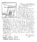
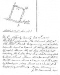
 In late summer of 1955, a group of descendant families and historians gathered at the site of Flat Rock Lutheran Church. Per a newspaper article dated 10 Sep 1955, Mrs. G. D. B. Reynolds, who was then president of the Stanly County Historical Society, spoke at the event about historical data that had been collected to date. Judge O. O. Efird from Winston-Salem spoke about the Efird family who were among the church’s founders. Others also presented and a committee was formed in hopes of obtaining a historical marker. At some point I plan to visit North Carolina State Archives to pull the original marker request. Within the church file housed in Stanly County is the following copy of the article as well as what I believe to be Mrs. Reynold’s personal handwritten speaking notes. It’s from that source where I learned that Flat Rock Lutheran may have a history reaching further back than most may realize.
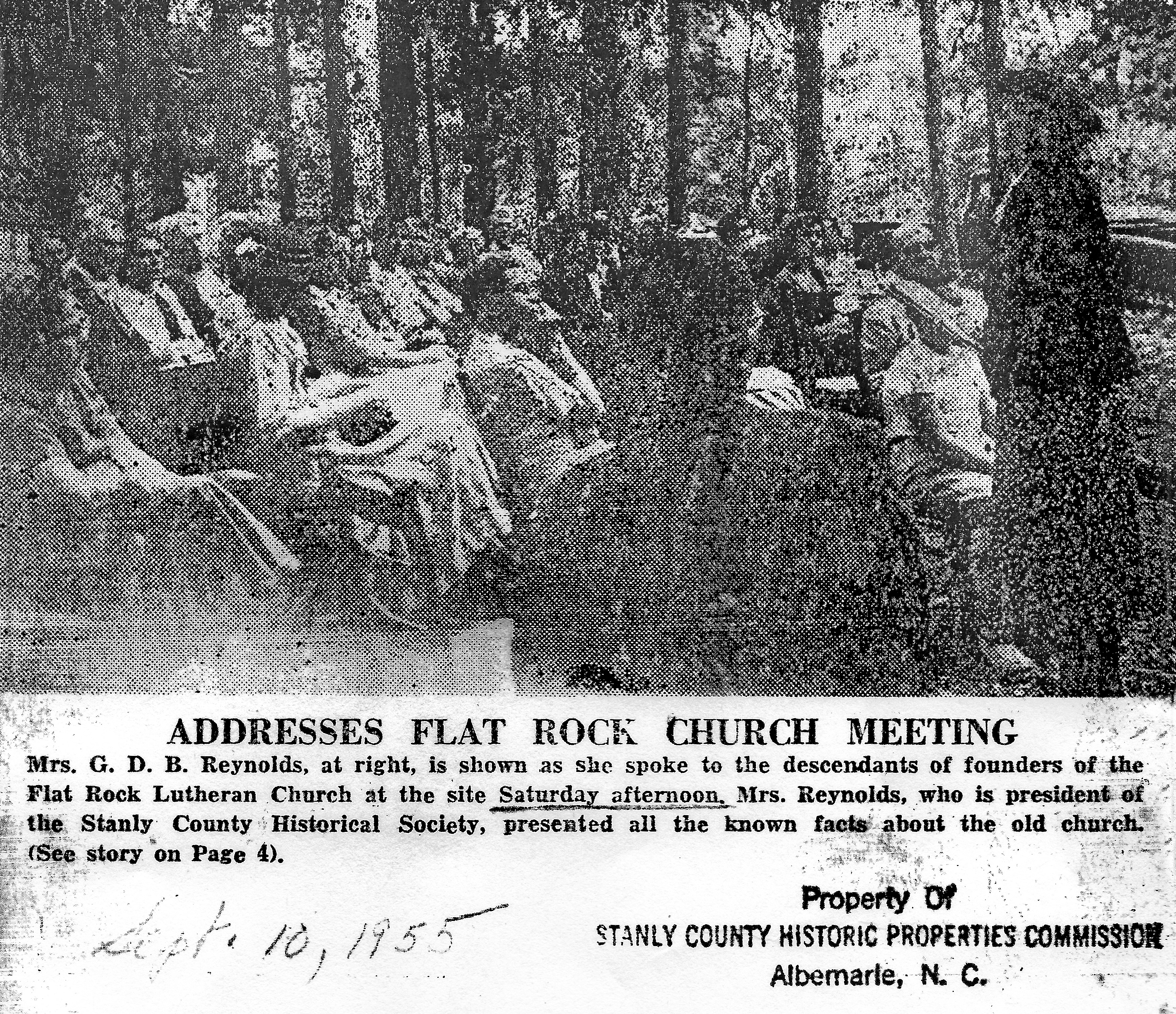


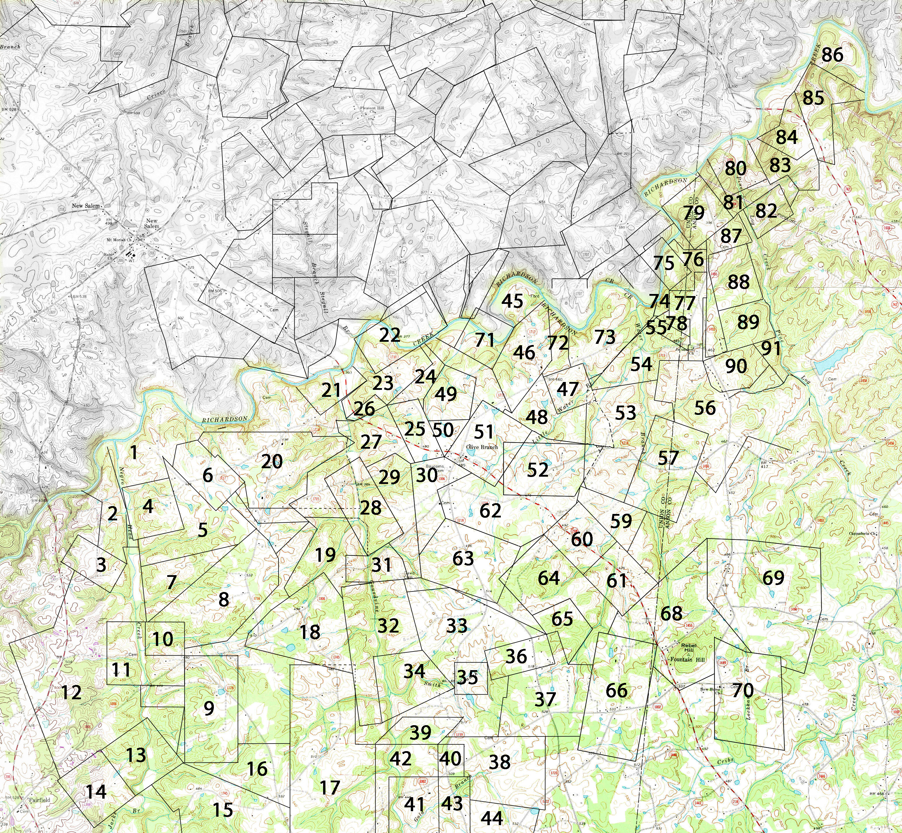


 From newspaper articles we know that John Beckwith once did business in Salisbury as well as Wake and even locations further east. But what were his intentions along this beautiful stretch of Rocky River? And, what happened; when did John Beckwith step away from this land holding? To find the answer we must look into the private


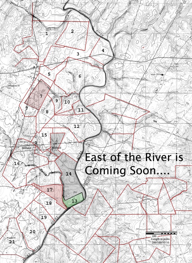
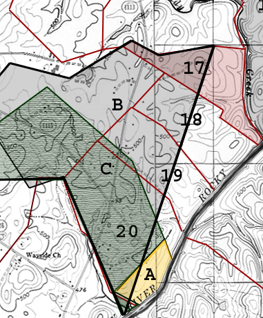
![swm[1]](https://rockyrivernc.com/wp-content/uploads/2018/11/swm1.jpg?w=625)