
Pierce’s New Map of the State of North Carolina – 1872
At this point I’m what you call an out-of-towner, a person who doesn’t live in the community where his ancestors possibly lived. I am also a person who’s willing to stumble all over himself any way needed to learn who my family was. For me this is all about culture …I want to know what life was like for them. And now learning that my family lived in Bertie County, my eyes have been opened to the dynamics of yet another place and generation back in time.
Can you imagine what it was like living on the Virginia / Carolina state line in 1700? North Carolina was young, crudely ruled and yet its fertile lands were calling. The new province lacked the governmental support readily available even just fifty years later.
For my folks who moved from Virginia ca. 1707, the communities in Chowan County (Bertie Province and later Bertie County) were small and the social hierarchy was steep. Your home back then would have been within easy walking distance of active and well established Indian villages. Some of the Indians were friendly while others were preparing to face the cruelty they found inherent in their new neighbors. Just as was experienced by the European settlers, the indigenous people were going through an even greater change.
Alongside the mix of indigenous peoples were slaves, indentured servants and a diverse mix of newcomers of the likes I can only imagine. It is said the region was a spiritual wasteland without organized religion. It was a place where people struggled meagerly in a hot, swampy and mosquito infested land. Life wasn’t good but alongside those who struggled were also landowners who at least had the means to make a proper go of it. The power structure was made of farmers, tradesmen, shipping captains, merchants, Indian traders, council presidents, and even governors. All of these folks lived very close to each other.
As for the Thomas family, the branch I may grow from lived on the west side of Chowan River on the north side of the Moratoc River. The name Morotoc refers to the name of Indians who once lived along the coastal river. The word means nice or “good river.” In other records the very same river is identified as Roanoke meaning Wampum in the Algonquin language. The Roanoke was considered a “River of Death” because of its treacherous spring floods.
When Joseph Thomas moved to the area around 1710-1729, his land was located on a branch of the Roanoke known as Cashy River. Only a few years after settling on the Cashy, in 1733, Edward Mosely created a map locating the river along with its surrounding Indian villages. In the lower portion of the map (below) you’ll see the villages of Ooneroy and Resootskeh with the “Tuscarora Indians” living in between. Tuscarora Indians? …who and what was that about?
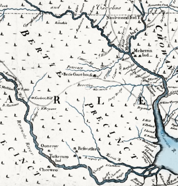
Edward Mosely’s New and Correct Map of the Province of North Carolina – 1733
The Tuscarora War (1711-1715) was fought between the European friendly Chief Tom Blunt living north of the Moratoc and Chief Hancock who lived south along the Pamlico.
Tuscaroran Chief Tom Blunt occupied the area north of the Morotoc (now southern Bertie County) where he lived in peace and was friends with a European family of the name Blount/Bunt. It’s believed the chief’s European name was taken by him out of respect for his neighboring Blunt family. On the other hand, Chief Hancock lived to the south along the Pamlico where a greater population of Europeans had abused his people to the point of even taking them into slavery. In 1711, alone and without support from Chief Blunt, the southern Tuscarora Indians under the lead of Chief Hancock attacked the settlements up and down the Trent and Alligator rivers. As a result of the outbreak, Governor Edward Hyde offered Chief Tom Blunt leadership of the entire Tuscarora Nation if he would simply help the governor to defeat Chief Hancock. With this, the war was on. Friendly Indians and troops from South Carolina were brought in and eventually Hancock was defeated. Following the war’s end, an exodus of Hancock’s southern Tuscarora removed to New York where they joined and settled among the Iroquois Federation near present day Buffalo. At that point any remaining peaceable Tuscarora were allowed to live in the aforementioned Bertie County villages of Ooneroy and Resootskeh. It’s for this reason the villages appear on Mosely’s 1733 map.
In 1718, a treaty was signed in which Tom Blunt was named King Tom Blunt. On behalf of the Tuscarora Indians the nation was granted 56,000 acres in an area known today as Indian Woods. Tribal attrition, encroachment by settlers, and scandalous dealings involving later tribal chiefs diminished the reservation. As per a 1708 Act of the General Assembly, and reflecting several 100+ year leases of the land dating back to 1766, a total of 41,000 acres was formally surveyed in 1803. The survey for that plat is below. Of interest, it’s now 300 years since the closure of the Tuscarora War. In celebration, a conference titled Three Hundred Years of Indian Woods, 1717-2017 will be held at the Hope Plantation in Bertie County. I am registered to attend the conference, hoping the experience will strengthen my perspective while allowing me to build valuable family connections. If you’re interested in the story of the Tuscarora, I’d encourage you to look more closely online at sites such as the Tuscarora Nation.

State of North Carolina}
Bertie County}
The above is a correct plan of the land allotted to the Nation of Tuscaroran Indians. The bounds of which are expressed in an Act of the General Assembly of the State aforesaid passed in the year 1708 which are as follows viz.: Beginning on Roanoke River at the mouth of Quitsney Swamp thence up the various courses of the said swamp to an oak near the head of the great spring, thence N 10 E 904 poles to a persimmon on Roquist Swamp thence N 57 W 2888 poles to a hickory at the head of Falling Creek Run or Deep Creek thence down the various courses of the said creek to Roanoke River, thence down the river to the first station containing forty one thousand one hundred & thirteen acres. The subdivision represents the second leases which appear to have been obtained from the said Indians subsequent to the 10th day of July 1766 and prior to the 1st day of December 1777 as will as the undivided residue which was in pursuance of an Act of General Assembly of the state aforesaid.
Certified under my hand this 17th of June 1803
The above plan and survey 17th of June 1803 W. H. Bryce – Surveyor
J. Slade} Commissioners for
William Hawkins} the said Indians
______________________________________________
The tribal war was over and now the land was primed for the ensuing migration of European settlers. It’s during this period when Joseph Thomas moved south from his land on the Oropeak to the Cashy River. Let’s attempt to connect Joseph Thomas’ 1729 relocation to Bertie County to the new land and to the Tuscarora experience.
Looking at the 1808 survey plat, note that the top right or northeast corner of the Indian Nation is situated on Roquest Creek nearly north of Quitsney Swamp on the Roanoke. Using Edmond Mosley’s 1733 map, Resootskeh Indian Village is situated north and west of the head of Roquist Creek on which the northeast corner of the tract is located. Looking a bit further north, you’ll see what’s known as Cashie Swamp branching west from the main course of the Cashie River. I believe Joseph Thomas owned land located in the fork of the river and somewhere along the Cashy Swamp. And adjoining the lands of Joseph Thomas, a person named John Blunt along with others owned lands reaching south and west from the above Cashy swamp to Roquist Swamp. John Blunt was likely a member of the family from which King Tom Bunt’s name was derived. Let’s reel forward a generation when Joseph Thomas’ son of same name was appointed constable of the lands from the fork of Roquist north to near the Cashy swamp. What a great clue and there’s more! Part of the estate lands of elder Joseph Thomas deceased was conveyed to his son Luke by his widow Alice. That deed was witnessed by a person named James Blunt. Note that King Tom Blunt of the Tuscarora was succeeded by a person named James Blunt. I’d like to provide more detail on all of this but doing so is very tedious and should be given a post dedicated to just that purpose (coming soon). But for now, note there is good information including a letter written by James Blunt in the “1740’s -1800” section of the Tuscarora Chronology. Also, an article titled Death of a Reservation offers a well-written overview of the Tuscaroran chiefs.
At this point the reader needs to realize that Joseph Thomas lived on the north side of the Tuscarora Nation on land that adjoined the Blunt Family who likely played a major role in defining early life in Bertie County. The Thomas family also interacted with others who certainly helped to shape our great state. It’s my hopes that this post provided the unknowing with a contextual starting point for studying the place and times in which Joseph Thomas lived. In following posts I’ll begin to look more closely at Joseph Thomas and the legal documentation recorded by his family while living along the Cashy Swamp in Bertie County.

I am curious what means of self-protection was available among several families in comparison to such a large indigenous community. It sounds as if one tribe was played against the other in an allied effort to counter the indigenous peoples to the South. Still in all, what arms did we likely possess? What did we have in trade that was of any value to the indigenous? It sounds as if Joseph Thomas # 1 was comparable to Daniel Boone, and Joseph Thomas #2 was comparable to Wyatt Earp. And another individual, Blunt, must have been a heck of a negotiator. I wonder if marriages between the settlers and the indigenous played an harmonious roll such was the case with John Smith and Pocahontas and John Smith/John Rolfe?
It all makes you wonder.
Just trying to do my wife’s genealogy research and to explain her Native American DNA. Found a maternal link back to a woman named Nancey Browne, daughter of a James L. Browne in Bertie who was supposedly a Lenape. I think, since they came from Indian Woods she was most likely Tuscaroran. Have you run across the Brownes? This would have been in the period from about 1710-1770. Thank you. Robert Gibbs
Thanks for the replay and wish I could be of help but my knowledge in Bertie is not that deep. However, will keep my eyes open and know there should be some groups out of the county that could be of help