Who was the Most Important Land Owner in Stanly County, North Carolina?

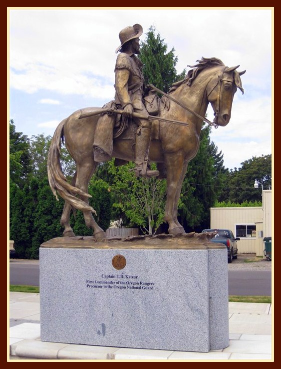
When contemplating this question, we might think of the King of England or possibly some local Stanly County family who made it big. But Stanly was not formed until well after Revolutionary War and there’s nobody to my knowledge whose station in life rises to the level of a person I have in mind.

thornton
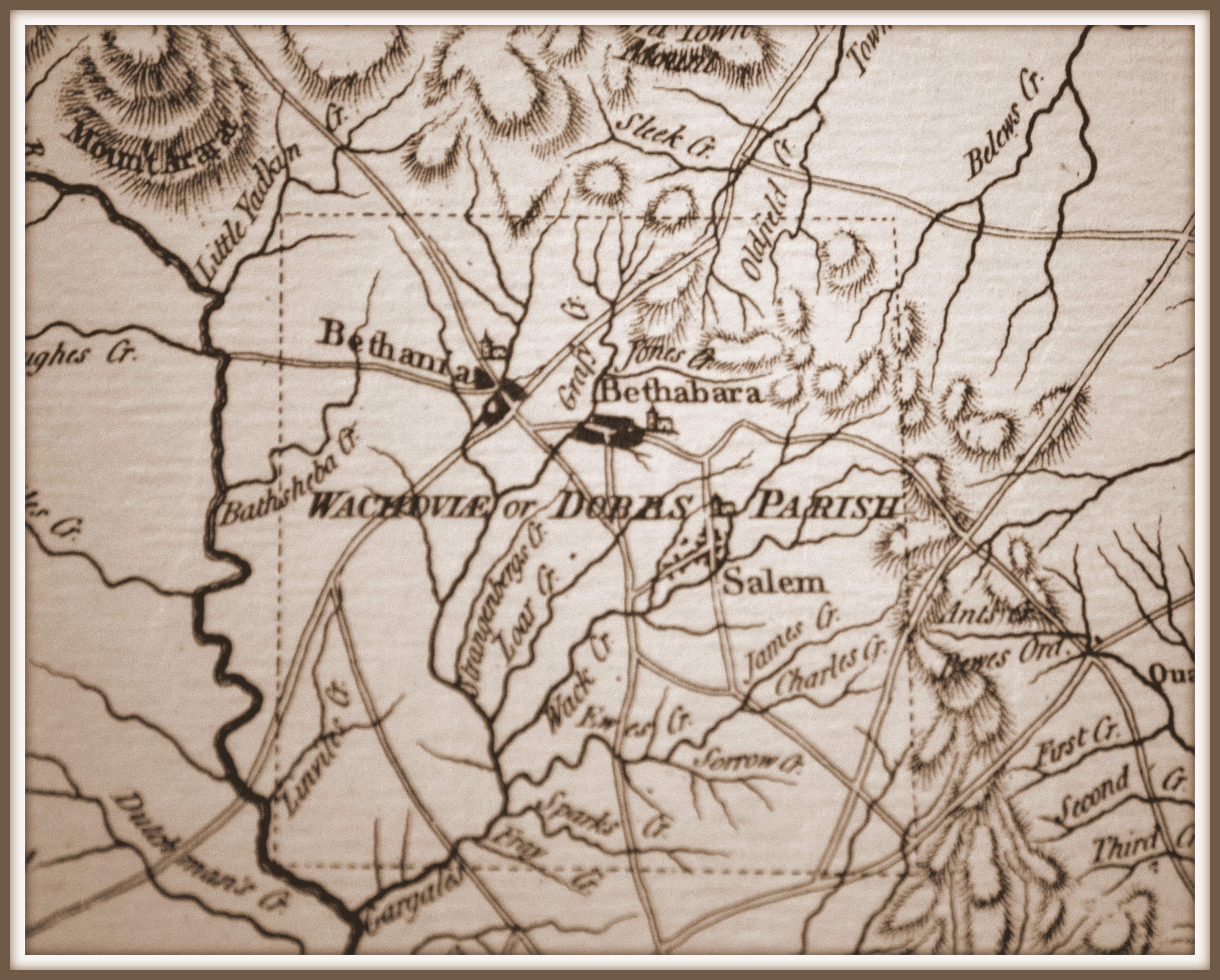
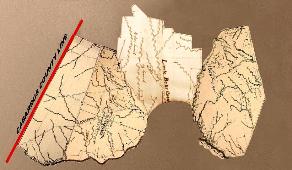
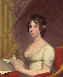
In 1790, at the age of 16, Anna Marie Brodeau married William Thornton, aged 31. Dr. William Thornton designed the United States Capitol Building and is considered the father of the United States Patent Office. Following the discovery of gold in Cabarrus County, North Carolina, William purchased over 50,000 acres of speculation land encompassing much of what is present day Stanly County. The following map I put together from original Secretary of State land grant survey plats show just how far Thornton’s lands reached. It was his intention to start a lucrative business known as the North Carolina Gold Mining Company.

stanlyland

After his death in 1828, William Thornton’s land passed to his wife Anna Marie by way of last will and testament. Though the gold mining venture failed, Anna continued selling off parcels of the land well beyond the 1842 formation of Stanly County. By rights, Anna was clearly the largest land owner in Stanly County. But, this fact alone is not why I believe her to be the most important land owner.

Celebrating something good within America’s most tragic moment, a well-done segment on CBS Sunday Morning portrayed the August 1814 burning and fall of Washington, DC. Two hundred years ago this very month, the British burned our capitol during the War of 1812. The TV story celebrated Dolly Madison by highlighting her saving of a famous portrait of George Washington.

640px-BurningofWashington1814
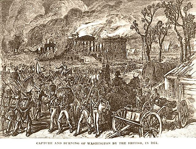
Anna and William Thornton were friends of Dolly Madison and lived close to the White House. On that fateful day, Anna retreated to a friend’s mansion on the Georgetown Heights, overlooking the Potomac. From their location, Anna and her host wrote of the unfolding situation while recording the movements of Dolly Madison. And seeing that the Patent Office was about to be burned, William Thornton himself made it to town where he persuaded the British to spare the building. Today, what was first a hotel, and later the first patent office, now houses the United States National Portrait Museum.

Years later, following the death of our first president, Anna Marie Thornton lobbied Congress on behalf of her friend Martha Washington. Though it was Martha’s wish for her husband to be buried on the family estate, the prevailing powers were adamant that he should be interred at the newly constructed monument bearing his name. Anna’s effort must have been of help as George Washington was laid to rest at Mount Vernon.

George Washington's Tomb at Mount Vernon

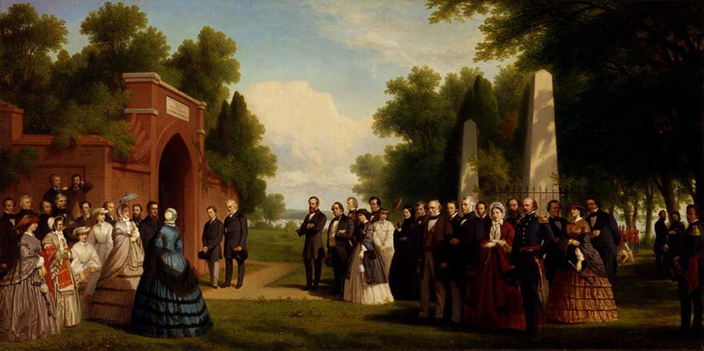
George Washington’s Tomb at Mount Vernon

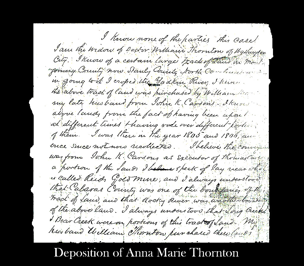
Later in life, a Supreme Court Case arising from Stanly County, North Carolina names Anna Marie Thornton in connection with the title history of her land holdings. The case includes her deposition along with a copy of the deed of sale for the large tract of land. Recently, I was contacted by the editor of the William Thornton Papers as it had been previously believed that there was no existing copy of Thornton’s land deed in North Carolina. You see, besides the copy found in the court case, the original had been destroyed when the Montgomery County, North Carolina court house was burned in 1843 by Elijah Spencer, an arsonist. And, the only other known copy was recorded in Washington DC only to be destroyed by the very same fire that Anna witnessed in 1814.
deposition
Along with being Stanly County’s largest land owner, Anna Marie Brodeau Thornton’s time and place in history helped to make our country what it is today. Anna’s diary can be found in the Library of Congress and there’s much information available on the  events of 1814.  One particularly good blog can be found at Washington Burning: Ladies of the Capitol

New Clues and a Thank You!

platDavid McCorkle lives in the Raleigh area; a distant cousin, he descends from Headley Thomas, a son of Ananias from Anson County NC. Our earliest known ancestor is Benjamin Thomas, father of Ananias. Maybe a year ago, David told me of his project to digitally record land grants from the area of Mecklenburg County NC. Knowing how much time and effort it has taken me to work a few small areas of Anson and Cabarrus counties, all I could think was uh huh ….have fun. Well, within the year, David has fulfilled his challenge and is now taking aim on records for the entire state of North Carolina …I can’t fathom the idea!

Years ago I had my own project. I sought to plat lands where Benjamin Thomas settled along the waters of Richardson creek in now Union County NC. Knowing Benjamin was NOT a child of the Stephen Thomas family in Richmond County to the east, I wanted to learn more about the people my ancestor called neighbors. Believing birds of feather flocked together, I hoped something in the land records would scream out and lead me to a more distant past.

It was a pretty slow process, drawing the old surveys to scale and connecting them to others using clues rising from the written descriptions. I was able to expand my own plat map only as long as the grants listed adjoining neighbors. Eventually, reaching tracts that did not identify adjoining lands, I was faced with what seemed to be an insurmountable wall. I would either have to stop the quest or reverse strategy by wading through ALL the grants in the county hoping to find OTHER pieces of land that mentioned adjoining Thomas lands. The haystack was too big; my project was put to rest.

This very day, whilst looking at the index on David’s site, I saw he offered a new choice. I could look at only Mecklenburg County land grants, or …..click and look at land grants from Mecklenburg and surrounding counties. Since David has somehow cross referenced ALL the grants, I was able to quickly find the much needed adjoining land owners. My project has new legs and I very much thank David for his diligence and good work.

Now, for those who have no clue about what I’ve just written, please take a look at David’s site: http://nclandgrants.com/home.htm. If your ancestor lived near Mecklenburg NC, type them into the index, see the land they claimed, and learn a little about who they called “neighbor.”

JJ: Finding Lost Love

In August 1877, Jno. C. Love of the City of Philadelphia Pa purchased the following tracts adjoining Reed gold mine and Rocky River:

• 30 acres of land from Aaron Linker and wife adjoining lands of “Moses Linker, Jackson Linker, Reed Mine Company & Rocky River.”
• An undisclosed amount of acreage from Aaron Linker and wife being “the tract of land on which they now live adjoining the Furr Garman Mining Company.” The land also adjoined that owned by Wm. Linker, and Jackson Linker.
• 60 acres (28-32, Cabarrus County NC) “on which I now live” … and joining Aaron Linker, and “the river at the mouth of the branch.”
• 154 acres from Geo. Barba & wife, being lands where Geo. Barba & wife now lives, adjoining the river, “a corner of the church,” “Reed & Hartsell’s corner,” and A. Hartsell’s corner.

These deeds found years ago stir deep thought as the lands must have been very near to that once owned by our own Grandsire James Love. Who was John C. Love of Philadelphia and did he relate to our NC family? Prior to opening the Charlotte mint, how was gold accounted in what must have been an arduous trip from Reed’s mine to the federal mint in Philadelphia? Was selling gold anything like selling hay; did we simply carry it in bulk, weigh it, and receive payment in money? Or, were there family or other agents in Philly who managed our interests? Of all places, why was John C. Love of Philadelphia buying land around Reed’s gold mine?!! The story of John C. Love is nowhere complete, though what we have reads like a classic southern tale. It even cracks the door open allowing us glimpses into the possible lives of other lost LOVE.

We know old Grandsire James Love had a nephew John C. Love who died much earlier in Stokes County NC. There’s no known descendants of our James by the name John C. Love; however, there was a John C. Love who enlisted and served along-side John E. Love, John J. Love, Jonah Askew Love, Michael Garman Love, James Wade Love and Postill P. Love in CSA Co. H, 42nd Reg NC.

On 30 Apr 1864, John C. Love enlisted as Private in Petersburg VA. He served under Capt. J. M. Hartsell and “joined from desertion Oct 18 1864 & deserted to the enemy Oct 29 1864.” A register of arrivals and dispositions of federal and rebel soldiers indicates J. C. Love was received Oct 30 1864 as a “Deserter from the Enemy” at Bermuda 100. From the register of rebel deserters taking oath, Headquarters, the Provost Marshall, Bermuda Hundred VA makes the following report. John C. Love was captured at Dept. Headquarters, Nov 4 186_ and confined at that time. On Nov 4 186_ he was turned over to Pro. Maj. Gen. at City Point VA with final remarks “To go to Philadelphia PA.” Looking at another paper, and on Nov 6 1864, charged as “Rebel Deserter,” Maj. Gen. U.S. Grant ordered that John C. Love be confined. He was sent on Nov 12 1864 to City Point where he was to be released. This by order of P. M. Gen Patrick. And again, the remark: “Went to Phila Pa.” Could it be? Is there a chance that this confederate soldier is the same John C. Love who purchased land in Cabarrus in 1877?

Poring through records from Stanly, Anson, Cabarrus and Union Counties, I found only one telling entry. The Jan 1867 minutes of the Court of Pleas and Quarter Session reads:

State vs. John C. Love
Suspended upon payment of costs.
E C. Griffin, Judgement of $50.

There was no mention of John C. Love in North Carolina census records, prior to or after the war. And though believing all LOVE in South Carolina descended from the likes of an early settler known as James the Weaver, the following census record from 1860 Jefferson Township in Chesterfield SC opens a door.

1860 Chesterfield SC

1860 Chesterfield SC

Born in North Carolina, James Love is listed as a carpenter living near the Brewer gold mine. The family does not appear in the county prior or after 1860. Note John C. Love, aged 13, would have sadly been of age to enlist in 1864. And also note that John C. Love’s father, (John) James Love is the same John J. Love enlisted beside John C. Love in the 42nd Regiment. More on the life story of John C. Love will have to wait for another day as the rest of this writing will be dedicated to the story of John James Love and other possible implications raised.

During and following the Civil War, J. J. Love and family first purchased land in Union County NC before moving to the Crab Orchard area of Mecklenburg. To my knowledge, there’s no further listing of son John C. Love in North Carolina. The family of J.J. Love:

Wife Mary Caroline Honeycutt Love, born 1823.
1. James Adam Love – born 1844, married Sarah Jane Griffin in 1866 Union NC.
2. John C. Love – born 1847 and is lost or possibly removed to Philadelphia.
3. Vicey Catherine Love – born 1851, married Churchwell G. Braswell 1867 Union NC.
4. Joseph Henry Love – born 1854, married Nancy Jane Harrington in 1874 Union NC.
5. Gustavus Beauregard “General” Love – born 1865, married 1882 Malinda Hinson.

Dated 28 May 1901, J. J. Love applied for a civil war pension claim. At age 78 and residing at Cluster branch post-office, he declared his service in “Co. B, 42nd Reg. NC. And in 1863, while in service at Seven Pines VA, he “received wound in left arm below elbow also on right leg.” Marking the death of John J. Love, dated 22 Jul 1904, 79 year-old Mary C. Love applied for widow’s pension while living in Rt. 2 Charlotte NC. She properly identifies her husband’s unit as Co. H, 42nd. Reg. NC. E. M. and Minnie Spoon witnessed on behalf of Mary’s claim. The following obituary marks the death of Mary just a few years later:

Obituary
Mrs. Caroline Love, widow of the late J. J. Love, died yesterday morning at 8 o’clock at the home of her son, Mr. J. B. Love, four miles from the city on the Mneville road. The deceased was one of the oldest women in, the county, being 83 years of age at the time of her death. She was a good Christian woman and had been for many years a member of the Hickory Grove Church. The interment took place at that church today. Mrs. Love is survived, by two children, Mr. J. B. Love and Mrs. Braswell, of Mint Hill.
23 Aug 1906 Charlotte News

Note that the death certificate for Gustavus B. Love indicates his mother’s maiden name was Honneycutt. Related or maybe not, there is a lost Love found in a bible record named Mary Fairly Love who married into the Honeycutt family. As with our J. J. Love, there are few to no records for Mary Fairly Love. However, there is also a person named John Fairly Honeycutt. In the tangle of Love, Honeycutt and Fairly is it possible there a possible family tie?
bible

Jesse Lee’s Preaching at Love’s Church

Please understand who I am and what drives me. I enjoy history, am a painfully slow writer and will only occasionally post on my blog site as I live with a work schedule that demands much of my time.

With that out of the way, let’s revisit an earlier post where, in October 1799, Rev. Jesse Lee and Francis Asbury spoke to a gathering held at Love’s Church in now Stokes County, North Carolina:

Monday 7. We rode through Stokes County, and attended meeting at Love’s church, which has glass windows, and a yard fenced in. After Jesse Lee, I added a few words on Hebr. ii. 1. We then came up to William Jean’s, near the Moravian Old-town. We have rode nearly twenty miles this day. Sitting in meeting so many hours among such a multitude of people, and frequently with a blister on my breast, with the difficulties of driving along broken paths, cause me to be variously tried and comforted.

It’s interesting that Asbury concluded the meeting with words on Hebrews 2:1

Therefore we ought to give the more earnest heed to the things which we have heard, lest at any time we should let them slip.

Beyond the assumed biblical interpretation, for us who study families and our history, it’s vital to listen well and engage in conversation that brings life to stories being told. Don’t merely seek to understand the prevailing thought, but make it real by taking time to learn more about the cast of players and how their mentioning adds to the story. From such perspective, I can only guess about Asbury’s sermon and how it related to the congregation of Love’s Church in the times that were. We can glean much from the Journals of Francis Asbury, but who was the above named Jesse Lee?

Jesse Lee

Jesse Lee

Born 12 March 1758 in Prince George’s County, Virginia, Jesse Lee experienced a state of grace in 1777 after which time he helped to bring Methodism to northeast North Carolina. Following the formal organization of the Methodist Episcopal Church at the celebrated Christmas Conference on 12 Dec 1784, Lee was requested by Francis Asbury to travel on a southern tour. In the piedmont of NC, while assigned to the Salisbury area, Jesse Lee preached to the Methodist community at the home of John Randle (known as Dumb John as he was deaf and could not speak). Located in present day Stanly County, Randall Methodist Church was formed. Jesse Lee is considered to be its fist “Circuit Riding Preacher.”

In 1789, Jesse Lee was sent north where he formed the first Methodist class in New England. He’s responsible for planting the seed of Methodism from Connecticut north to Maine. Remaining friends with Francis Asbury, Jesse Lee served as his assistant from 1797 through 1800. It was during this time that Lee spoke at Love’s Church in North Carolina.

Jesse Lee was appointed Chaplain of the United States Representatives in 1809 and then again in 1812. On 24 Aug 1814, Washington DC was tragically burned during the War of 1812. Following what must have been a horrific site, Jesse Lee was appointed Chaplain of the United States Senate a month later on September 27, 1814. He died in 1816 and is buried in Baltimore, Maryland.

In the short paragraph from Asbury’s Journal, there is mention of another person. Who is William Jean and how does he expand the story? More later…

Tried and Comforted

Sunrise Service at God's Acre, Winston Salem NC

Sunrise Service at God’s Acre, Winston Salem NC

“At five o’clock the congregation gathered in the Saal, and after the usual greeting went into procession to God’s Acre. The weather was fine.”

I can hear the proclamation by horns, the singing of “Christ the Lord has Risen Today” and the quietness of believers solemnly making way to the burial ground. And though the resurrection of Christ is celebrated similarly across our country, this was not your normal Easter. On 12 April 1788, the above quote was entered into diary by a Moravian minister in North Carolina’s settlement known as Wachovia. The minister continues his entry with the following:

Twenty-three Methodist preachers passed through on Good Friday on their way to Mr. McKnight’s to hold a Church Meeting as they call their conference, and stopped today on their return trip. The meeting had been called by Mr. Coke, who recently came from England to make a visitation among the Methodists in North Carolina. During the meeting seven deacons were ordained. They say that in addition to this church order, which is the lowest, they have elders (presbyters) and bishops. Mr. Coke claims to be a bishop, and this is confirmed by Mr. Astley [Asbury], the leading preacher and superintendent among the Methodists here. From here Mr. Coke goes to Virginia, where he has called a meeting and will make a visitation; and he will continue his work through all the states as far as New England. The Methodists make such visitations here and there each year.

wachoviaBelieving they were about to be expelled from Germany, in 1754, the Moravian Sect under leadership of Von Zinnzenburg purchased 99,000 acres in western NC. Known as Wachau [Wachovia] in honor of the Wachua Valley of Austria, the land was subdivided amongst their own by way of church agent. Situated along the Indian Path that later became known as the Great Wagon Road from Pennsylvania, others, including Methodists, soon sought settlement on their tract. The Moravians were great keepers of diaries and other forms of social accounting. Much more about the growth of Methodism in our state can be gleaned by reading the volumes of Adelaide Fries’ Records of Moravians in North Carolina.

francis-asburyAnother wonderful source for understanding our past can be found in the Journal of Francis Asbury. We Methodists know well of the founding leadership of John Wesley, but it really was Francis Asbury whose journeys across the back country solidified our ways of worship. In October of 1799, while passing through the western wilds of North Carolina, Asbury writes:


Friday 4. We rode twelve miles to Mrs. Campbell’s, upon the south fork of Haw River. We had to work our way through the woods. Saturday and Sunday, I attended quarterly meeting at Bethel, upon Belew’s Creek, where I ordained five deacons, and preached from 1 Tim. vi. 11, 12.: we had a gracious time. We have rode only twenty miles in two days. I lodged at M’Daniel’s.

Monday 7. We rode through Stokes County, and attended meeting at Love’s church, which has glass windows, and a yard fenced in. After Jesse Lee, I added a few words on Hebr. ii. 1. We then came up to William Jean’s, near the Moravian Old-town. We have rode nearly twenty miles this day. Sitting in meeting so many hours among such a multitude of people, and frequently with a blister on my breast, with the difficulties of driving along broken paths, cause me to be variously tried and comforted.

The study of history and genealogy is much akin the journeys of Francis Asbury. We push forward on a broken path of records alternatively encountering  times of delight and torment. The Moravian records, along with this entry by Asbury, provide a wonderful wellspring of information from which new posts will flow.

Though the church of James Love has been identified, his life on earth will soon after end. His closing chapter will lead us in new directions. Future writings  will explore family, friends, church, and even an incredible walk by a man named Moses.

The Trail to Oregon

Thomas Dove Keizur Monument

Thomas Dove Keizur Monument

courtesy of  Ginger Powers

courtesy of
Ginger Powers

His life was a great adventure! The son of George A. and Mary Dove Keiser, Thomas Dove Keiser was born Nov 20, 1793 in a portion of Mecklenburg County NC that would soon become Cabarrus. He married in 1812 Mary Gurley, the daughter of James and Lydia Gurley. James was the son of William Gurley who settled ca. 1778 alongside my THOMAS ancestor on Richardson Creek in Anson County NC. In 1828 Thomas Dove (T. D.) Keiser and family removed first to Tennessee before journeying on to Arkansas.

With T. D. Keisur helping to lead the way, on May 20, 1843, the family loaded the wagons once more and joined the great Applegate wagon train to Oregon. Settling along the Willamette River in the Pacific Northwest, the region was not yet governed under the jurisdiction of the United States. A community based security force known then as the Oregon Rangers was quickly raised. Thomas Dove Keizur was chosen and served as first captain in this precursor to the United States National Guard. He continued a life of civil service benefiting the new state of Oregon along with the town that now bears his name.

As is the way with most of history, I never knew of T. D. Keizur until his story came to me by way of the works of others. During the Christmas holiday in 2009, a Keiser family member contacted me in advance of a major celebration about to take place in Oregon. On January 30, 2010, the little town of Keizer Oregon unveiled a bronze monument of Thomas Dove Keisur seated atop his faithful Morgan horse. Historian and author Jerry McGee provides a historic presentation on T. D. Keizur and the town.

______________________________________

In 1780, Henry Kent sold land on Utley Creek (F-1, Wake NC) to Davie Strait after relocating briefly to Mecklenburg (now Cabarrus County NC). Deed 11-31 in Mecklenburg NC identifies Henry’s land as lying on “the waters of Rockie River Nigh the Baptist Meeting House.” This was an intriguing find as it tied to my LOVE family while illuminating the migration from an area of northeast North Carolina where my THOMAS family may have once lived. More on these ties in a later post.

Believing land records had pointed me to the old Baptist church, I contacted the land’s present owner and was graciously shown the way to what I sought. Followed by an inquisitive herd of cattle, we walked a grassy ridge that provided panoramic views of surrounding pastures and the distant Rocky River basin. Rising to the north, and flowing around the land, was a spring head identified in early deeds as feeding “Meeting House Branch.” Eventually we reached an ancient hilltop cemetery in a small grove of trees. Though well taken care of, time and life had taken its toll on the graveyard. Just a few stones revealed readable words such as “the” or maybe “here.” The following is a digital image of the only surviving stone with words crying out to be deciphered.

stone.jpg

Further research revealed this to be the site of “Haynes Meeting House.” Lutheran minister David Henkel preached at Haynes Meeting House around 1800 and it’s also identified as the burial place for members of the Howell family. Found also in local land records, namesake William Haynes removed to western NC by 1785 and became the first preacher at Bill’s Creek Baptist Church located near present day Lake Lure.

IMAG0240Frequently visiting the site in search of things possibly missed, on one such trip, the door of discovery opened once more. Partially buried under leaves and debris, a small stake of a rock identified the resting place of Levi Keiser. From the works of Marie Evans Davis-McQueen, I learned that Levi was born Feb 16, 1783. The son of George Alexander and Mary Dove Kiser (Kiser – as tradition spells it in NC legal records), we now know the little fellow died Feb 11, 1789. Not long after the death of little Levi Keiser, his brother named Thomas Dove Keiser was born November 20, 1793. And since Levi’s mother and father lived out their lives in the area surrounding the graveyard, it seems they would’ve wanted to be buried there, near their son. I couldn’t help but imagine that they and others in the family were buried nearby.

After learning of the amazing life journey of Thomas Dove Keiser/Keizur, I decided to revisit the old unreadable stone with an open mind to variations in naming. Amazed at what I now see, I’m almost certain the stone marks the resting place of T.D.’s and little Levi’s father.

When I visit that hallowed ground off of Hwy 601 in Midland NC, I think of journeys and of how all things are possible. There was of course the trip to Oregon and the Gurley family’s earlier migration from Johnston County NC. It’s wonderful getting to know the wealth in community and how it was served by this little church named Haynes. Though he never got to meet his younger brother Thomas, I’m sure little Levi would have been proud of his life’s journey.

James Allison Love and Grandsire Jimmy

family
My maternal ancestor is James Love, born in the early-mid 1700’s possibly in the area of Brunswick County VA. The son of James and Elizabeth Love, he did in fact live in Brunswick County prior to moving westward through the south side of Virginia before crossing the border into old Surry County, now Stokes County NC. He moved deeper into the foothills of Wilkes County NC where his son John served in his stead during the revolutionary war. John remained in Wilkes County as his father James and family moved east to Mecklenburg, now Cabarrus County NC. Our James Love, fondly known by us as Grandsire Jimmy, is well recorded in the annals of time. Though I’ve seen him listed as James Jr. and James Sr., his purported middle name Allison has never been recorded to my knowledge. That being said, where does the name come from and how did its use come to be?

adamAll evidence goes back to information provided to my great uncle James Adam Love, son of John Ephraim and Frances Isabelle Hinson Love. The author of The Rocky River Love Family, Adam frequently read his story during the Love family reunion at Love’s Chapel UMC in Stanfield NC. I remember so many times my mother telling of him standing before the congregation reading from the history. Old Mump Love leaned forward with ear horn in hand listening carefully to every word said. Following the program, the gathering adjourned to the grounds where a great spread of food awaited. Just a little girl then, my mother remembers large barrels of ice tea and the pleasures of family and fellowship. It’s almost as if I were there.

James Adam Love died 6 Apr 1939 and is buried at Love’s Chapel. A letter from his collection was given to his sister (my Grandmother), Minnie Ann Love. It’s a correspondence Uncle Adam had received from a distant cousin in Pope County AR whose ancestors had left Stanly County back in the mid 1800’s. Mrs. Robert Bigham Henry wrote of her grandfather Darling Love and of her family’s rich history. From a visit to Helen Tucker Obermeier in Stanly County NC, I learned of the existence of Adam’s response to the letter written by Mrs. Henry. From a typed copy obtained from Myra Norwood, Helen allowed me to copy James Adam Love’s letter of reply. Written in August 1932, he announced success in what was the first ever Love Family Reunion. He writes of a day of reading and singing and confirms the spirited event just as has been passed down to me by my mother.

Listen up as this upcoming sentence is important. From family in Arkansas, we know Darling Love had a son James Allison Love whose daughter passed on that he, James Allison Love, was named for his grandfather. Court records here in NC opened the door, allowing this prevailing thought from Arkansas to be mistakenly associated with the life record of old Grandsire Jimmy. At that day and time it was believed against all likelihood that Darling Love was the son of old Grandsire Jimmy. Darling was born ca. 1815 and Grandsire Jimmy was born ca. 1745. Read the letters closely and you can sense the miscommunication in the correspondences between my great uncle and Ms. Henry from Arkansas.

petition7Since the days of Adam Love, two discoveries offer new possibilities. Most recently found, DNA from descendants of a James Love born ca. 1764, who died ca. 1824 in Campbell County GA, matches that from descendants of our Grandsire Jimmy. And, a petition in support of constructing public buildings ca 1794 in the newly formed Cabarrus County names James Love Sr. and James Love Jr. More than likely, James Love, who died in Campbell County GA is “Jr,” being the son of Grandsire Jimmy. There’s no mention of Allison in records of either James Love Sr. or Jr.

During the War of 1812, a person named James Love served in a unit raised in Cabarrus County. This could not be old Grandsire Jimmy nor James Love who later died in GA. They‘re simply too old. Per the unit roster, Private James Love served under Captain Evan S. Wiley who served under Lt. Col. Richard Allison. Could this James Love be the father of Darling Love and could Darling have named a son for a leader of the unit in which his dad served? And when Darling Love’s granddaughter said that her father James Allison Love was named for his grandfather, could the namesake have been this private who served in the War of 1812? You bet, but what ever happened to this James Love?

Helen Tucker Obermeier introduced me to a record that few others had seen. Dated 3 Sep 1858, the 62 year-old “Mary Brooks” applied for bounty land she believed due her on behalf of military services rendered by her deceased husband James Love in the War of 1812. In the two-page affidavit, Mary states she and James Love married 10 Aug 1813. And “…her name before said marriage was Mary [Polly] Tucker.” James and Mary were married by Isaiah Spiers, Justice of Peace of Cabarrus County. Two years later James Love enlisted about 10 Aug 1815 in Concord, Cabarrus County NC. James Love served for fifteen days until being honorably discharged 2 Mar 1815 at Wadesboro in Anson County. The unit returned home due to ratification of peace with Great Britain. Mary states that her husband James Love “died on Rocky River [at his residence] on the 8th day of April 1825.” Mary Tucker Love married 16 Sep 1828 David Brooks in Montgomery County. They were married by John Little, Justice of the Peace. Mary goes on to state that said husband David Brooks died about 1 Aug 1842. G. H. Honneycutt and Jonah Love witnessed the affidavit.

More on this James Love can be found on my site at: http://www.angelfire.com/nc/benjthomasofansonnc/lovetucker.html

Traditional family history had it that late in life, old Grandsire Jimmy had four children named Darling, Pleasant, Hartwell, and Nica Love. And after his death, the children were raised by George Tucker and wife. We now see this younger, previously unknown James with wife of maiden name Tucker. Was she George’s sister? Even if not, the record gives a hint at why George raised the kids after the death and remarriage of Polly.

In bringing this post to close, there was no Allison in VA tied to the family in such a way to be the namesake of our Grandsire Jimmy. However, there were plenty of that name in the area surrounding Cabarrus. I believe it’s wrong and a mistake that we refer to old Grandsire as James Allison Love. The records instead point to the younger James who married Polly Tucker. This James could be the son of the James who moved to GA. He could also be the son of Thomas Love who also lived along Rocky River. He could also be a son of a son of Grandsire Jimmy who died young and has not been found in record?

Bessie and the Beef Shoot


Shooting for the Beef - George Caleb Bingham

Shooting for the Beef – George Caleb Bingham

I remember as a little kid struggling to peer over my dad’s arms while he whittled us kids flutes made from the hollow stems of squash leaves. Though the instruments more or less squawked, you could truthfully say they worked …at least for a minute or two before turning to mush.

One day at around age eight, I just happened to observe something going on that was not meant for my young eyes. My dad and older brother were seated at the kitchen table where my dad had a knife and wood in hand. Working on a scouting requirement, my dad’s attention was rightfully on my brother, not me. By and by, and not wanting to be left out, I made it to the tool shed where a chisel and piece of 2×4 caught my attention. It didn’t take long for the chisel to find its way off the wood, severely splitting the end of my finger. Scared to death and having to show the dripping wound to my dad, he pulled out the doctoring stuff and went to work. As always, his last move was to give me a smile, give the bandage a squeeze and then gave me the warning not to do that again. To this day my unhealed scar and split nail are always there reminding me of the good memories of youth. The accident also drove me on a journey that has defined my adult life. For many years I’d rather be carving wood than eating a good meal.

Though I knew little of art as a kid, I did know what I liked. And for me, classical American landscapes have always pulled me to another day and time. From images of animals grazing, people at work, the glow of early morning light, and maybe a ray of sun glistening on a faraway hill, the 1800’s luminst style of painting in particular speaks to my heart.

One of my favorite paintings was “Shooting for the Beef” by Caleb Bingham. Even though I was a city kid, I got the message that the painting was of a scene like a turkey shoot with the prize being a beef cow. I loved how the image captured real life in rural Americana.

Acting on my desire to recreate the image in wood, my dad carried me to a lumber yard where he bought me a huge piece of mahogany that I cut, glued up and carved on for years. Since the wood turned out to be longer in scale than the painting, it was necessary to be creative by exploring my own ideas to lengthen the carving. As the painting showed only the front end of the cow, I decided to include all of the animal for which a wonderful photo was found in the family set of Encyclopedia Britannica.

After countless hours of work, my carving was complete and I was truly proud. Giving it to my parents to go over their mantel, my dad helped to make brackets and bought a special light. It made me happy to see my parent’s pride in sharing my work with friends and neighbors.

And then one day, late in my grandmother’s life, dad brought her to the house for a weekend visit. My grandmother lived to 98 and was a person who actually lived the kind of days and life portrayed in my work. She grew up in hard times and was yet the warmest soul I will ever be privileged to know. Not being able to say enough good about my grandmother, I’ll never forget her remark after seeing my carving. With chin in hand, she gazed the people and landscape until her eyes reached the cow. She shook her head, smiled, and said “why child, you’d eat Bessie?”

Failing to acknowledge the importance of the working ends of beef cattle vs. a dairy cow, all the time and effort I had spent boiled down to whether an animal had teats or not. And my grandmother was right on. You’d never take the life of such a prized Jersey cow to fill a plate with meat! For me, this was a valuable lesson. There’s so much that you need to get right in life and there’s plenty of opportunity for mistake. Know your subject and do your best to get the story right. Composition is more than the image, it’s also the resulting story that’s being told.

Shooting for the Beef -1982

Shooting for the Beef -1982

Regulators and the Blackened Face

I thoroughly enjoyed my days at NC Archives reading through state level petitions and court records from the opening days of our country. The time spent was not only about organizing my own understanding of history, there was also the raw pleasure in finding the occasional deposition or petition having all the elements of a good a novel. Some cases were deadly serious while others were beyond funny.
__________________________________

In 1771, General Hugh Waddell was heading north from Salisbury to Hillsborough to quell a rebellion of regulators. Intended as support for Waddell, a convoy of munitions from Charleston camped in now Cabarrus County was attacked during the night by locals who hid behind blackened faces. Known today as the “Cabarrus Black Boys,” I wonder if there were other such attacks or similar acts by Regulators in the southern piedmont of North Carolina?

A year prior to the attack on Waddell’s munitions, the Anson county surveyor named Robert Jarman was robbed as he headed east from the Peedee river. He too was attacked at night and by men with blackened faces. And just a year earlier than the robbery, regulators of Anson County signed a petition.

Robert Jarman provided a deposition of the attack to the Governor’s Council in 1770. Though it could have been all about a robbery, one line screams that the crime might be the doings of the Regulators. Can you pick it out from Robert Jarman’s deposition below? Warning: this is a graphic read!

North Carolina                                                                     December 10, 1770
Craven County

The deposition of Robert Jarman of Anson County in the Province aforesaid, Deputy, Surveyor, aged about thirty eight years, who being sworn upon the Holy Evangelists, deposeth and saith, that about two hours after sunset in the evening of the twenty ninth day of November last past, as this deponent was riding the road from Blewit’s Ferry on the Peedee River to Cole’s Bridge on Drowning Creek near an old diserted cabbin on a branch of Hitchcock’s Creek commonly called the Chalk Fork, he this deponent was robbed of five or six shillings in small pieces of silver, forty six shillings in Proclamation Money, and fifteen Portugal Pieces of Gold commonly called half Joe’s, in the following manner, to wit, As this deponent had passed the said branch about twenty or thirty yards from the ford thereof, he this deponent saw three men all armed with guns, rush suddenly out of the said cabbin and run towards this deponent, whereupon this deponent put forward and spurred on his horse with all his might and the said three men advancing toward the road aforesaid to meet this deponent, some of them cried out repeatedly, Damn your soul, stop, or we will blow your brains out, whereupon this deponent immediately attempted to take a pistol out of his pocket, but hearing at the same instant two of them cock their guns as they came within about six or seven yards from this deponent, he desisted from making any defense, and stopped his horse under the greatest shock and surprise, and thereupon one of the men immediately stopped, and presented his gun at this deponent, another of them seized this deponents horse by the bridle, and the third man seized hold of this deponent, pulling and shriving to get him off his horse, and at the same time cursing this deponent in the most shocking manner, and ordering him to deliver up his money, or they would instantly kill him, but he who held the deponents horse by the bridle, said damn him, leave off pulling him, and get his money, whereupon the others desisted in pulling this deponent, and began to search his pockets on the side he then stood, but finding no money there, he went round to the other side of this deponent, and took out of this deponent’s fob, about five or six shillings in small silver, and then took hold of this deponent’s saddle bags and began to search them, and from thence took out one parcel of this deponent’s proclamation money, and at the same time cursed this deponent, and said, I have got some of your money, and I’ll be damned if we don’t kill you if you don’t tell us where your Gold is, whereupon this deponent told him he had none, but the other replied, I know you have some, and damn you, we will kill you if you don’t give us all you have; yes damn him, said the other who held this deponents horse by the bridle, and we will have his cloaths too, I do insist out. No damn him said he that was searching this deponent, we will take nothing but his money, and finding another parcel, here, said he, I have got other bundle of his proc and we will have all he has got, or damn him we will kill him, and then immediately finding the fifteen half Joe’s, took them out of this deponents saddle bags and swearing by his Maker, said, Boys, we have got it, and seemed then to be contented, and began to return and put up into the saddle bags some of this deponents cloaths and things which had been taken out in the search, and takin up a bottle of rum belonging to this deponent, held it up between himself and the moon (which at this time shone very bright) and swore that if they did not take the bottle they would have the rum, and then drank to him who held this deponents horse by the bridle, and taking the bottle again, carried it to him who had stood with his gun presented at the distance aforesaid, and after drinking two drams a piece, the same person who had been searching this deponent, drinking to him that held this deponents horse by the bridle, said damn me boys, we have done it; No, said he that held this deponents horse, I want his cloaths too; No said he that searched this deponent, we have got what we wanted, and I’ll be damned if we will have any of his cloaths and then put the said bottle again into the deponents saddle bags, and then upon the said two persons who had seized hold of this deponent and his horse, left this deponent and went to the other person who had stood with his gun presented at a distance of about five or six yards from this deponent as aforesaid, and then all three of the said persons advanced about four or five step further from this deponent, and there stood talking together, whereupon this deponent pleaded with them not to leave him destitute of any money to ______________ his _____________, and in answer thereto, one of them said damn your blood, go off this instant or we will take everything you have, for I will be damned, continued he, if there shall ever go as much money again out of Anson to the damned sons of bitches below, as there has gone, if we can help it, and thereupon this deponent left them and proceeded as fast as he could to John Cole’s at the bridge on Drowning Creek aforesaid, then being in such concern, terror and confusion, that he scarce knew what course to take, And this deponent further saith that the said three men who robbed this deponent aforesaid are all unknown to this deponent, their faces being all blackened and disguised, and that those two who had seized him and his horse in the manner aforesaid, were smallish or rather under a middle size, and that he who stood off some distance with his gun presented at the time of the robbery committed as aforesaid, appeared to be a tall stout man, who never spoke during the whole action, to this deponents knowledge; that all three had in hunting shirts, and all wore their hair, the two former had their hair hid, the latter had his hair short and loose about his neck. And this deponent further saith that at the time when this deponent desired and intended to have lit out on his journey from home with company, his wife was in labour, and in such circumstances as humanity forbade him to leave her in, that that the day after she was brought to bed, he set out on his journey and rode late at night at the time he was robed as aforesaid, in order to overtake the company which were on the road before him, and further this deponent saith not.

Rob’ Jarman

Sworn the tenth day of December, 1770 before R. Cogdill

Where the Indians Walked

wnorthwestweb

During the late 1990’s, I began a project to map land records in southern Cabarrus County NC in hopes of building a better understanding of the surrounding community. Granted lands were located and conveyances documented several transactions out from their origin. Every new piece added to the growing puzzle opened new possibilities and raised new questions. Much of my blogging effort is based on discoveries made during this effort.

Looking at the above map of land grants, the following descriptions are important to understanding one such discovery:

7. Grant # 3119, Mecklenburg NC, ent. 1 Jun 1779, sur. 10 Mar 1780, iss: 22 Oct 1782. Issued to Charles McCammon, being 195 acres on the south side of Rocky River “opposite the mouth of Coldwater Creek.” The metes and bounds are: from a b. o. on Thomas Watson’s line near the Indian Path, running with the line) north 41 east 14 to hic. grub (said Watson’s corner), (with his other line) north 88 east 42 to two pines (Watson’s other corner), with another line of his) south 88 east 61 to a w. o. sapling (another corner of said Watson), (with another line of his) north 69 east 64 to b. o. (another corner of said Watson), north 10 west 64 to w. o. sapling (on bank of river), up said river to r. o. on bank, west 57 to b. o. sapling, north 24 west 48 to ash (on bank of river), up the river to w. o. and ash (on bank of river), south 16 west 100 to hic. grub, then to begin. CC: Charles Dorton, John Love
8. Grant # , Mecklenburg NC, ent. _____, sur. 18 Aug 1780, iss. ____. Issued to Thomas Watson, being 135 acres on the waters of Horse Branch. he metes and bounds are from two pines (his own and Charles McCammon’s corner, running then with McCammon’s line) south 88 west 42 to hic. grub (his other corner near the old Indian path), (with his other line) south 41 west 103 to b. o. (near said path near John Love) south 34 to b. o. sapling, south 54 east 100 to stake (near Charles McKindley), north 83 east 47 to large hic., south 60 east 86 (crossing two branches of the horse branch to a corner of the place he lives on) to a stake, (with his own line) north 108 to stake (his other corner, (with his other line) west 92 to stake (another corner of his), (with his own line) north 103 to begin. CC: John Love, Charles Dorton.
12. Grant # 3052, Mecklenburg NC, ent. 2 Aug 1779, sur. 3 Mar 1780, iss. 22 Oct 1782. Issued to William McAnulty, being 156 acres on the waters of Reedy Creek. The metes and bounds are: from two b. j. (on the Indian path, running thence with Charles McKindley’s entry) south 30 west 132 to b. o., (with said McKindley’s entry) south 22 west 33 to b. o. (David McKindley’s corner), (with this line) north 58 west 66 to b. j. (near said McKindley’s other corner), north 45 west 127 to w. o. sapling, north 16 east 101 to hic. (near Robert Davis & James Love’s entries), south 61 east 106 to stake, then to begin. CC: Charles McKindley.
26. Grant # 3174, Mecklenburg NC, ent. _______, sur. 10 Apr 1780, iss. _______. Issued to David McKindley, being 228 acres on the head waters of Anderson Creek. The metes and bounds are: frpm a b. o. north 58 west 60 ( with William McAnulty’s entry) to small w. o., south 65 west 55 to pine, south 47 west 108 to r. o. (on the Indian path, south 58 west 83 to hic. , south 46 east 84 (with Hugh Campbell & Joseph Bigger’s entry) to s. o., east 126 to long b. o. , north 62 east 109 to w. o., north 18 east 60 to small b. o. (by a pond), with Charles McKindley’s entry) to begin. CC: Samuel White, Charles McKindley.

In 1782, Charles McCammon received a North Carolina Secretary of State land grant (#7 above) for 195 acres on the south side of Rocky River opposite the mouth of Cold Water creek. Unlike any tract of land I had seen before, this grant effectively excluded a triangle of land along the river bank that would have normally been included (see the green triangle in the above plat map).

The excluded triangle of land had no meaning what so ever until, having sufficiently platted enough surrounding tracts, an awesome ah-hah moment revealed itself.

Notice the little black triangles in several of the above tracts (tracts 4, 7, 8 13, 26). The surveyor noted in his plats that these were points where the granted parcels of land joined or neared the “Indian Path.” Connecting the triangles, it’s easy to follow the path to its river crossing somewhere in the green triangle at the mouth of Cold Water creek.

Raising as many questions as answers, the discovery gave me a unique opportunity to stop and look closely at how the crossing and records fit into the greater scheme of things. Zeroing in on the green triangle located in tract #7 above, the first question raised was “what was so important that led the surveyor to exclude the land around the crossing?” Could there be a burial ground near the crossing? Was the land excluded in order to allow passing Indians a place to camp?

I made several trips to what is now a relatively new housing development along the river. There, I was met by a group of boys who led me on a hike along the river bank. A small drain and hill angled into the river from the bank. It’s said that Indians paths run the high ground and cross running water in shallow points. If that is true, then the site perfectly fits the Indian need. Though I did not find any hint of a burial ground, I suspect the area would make for great archeological project to be undertaken by a local college.

It’s also said that Indian paths were first and that the Dutch Wagon Road simply improved on the path already in place. Though using wheeled wagons, the incoming settlers required a more gentle approach down and crossing the steep river banks. Not shown in the map above, and moving away from the river on its northern bank, tracts on the north side of the river are identified as joining the “Dutch Road.” The wagon road actually left the Indian path and turned east as it neared the river on the north bank. This was because of steepness in the area and also because of a dam built just downstream by Peter Kizer. The best place for wagons to ford the river was in the shallow water below the dam.

Looking back to the green triangle of land, it remained vacant land for nearly 50 years when John H. Bost received a grant for acreage on both sides of Rocky river that included the little triangle. I’m sure this land had a history before the days of John Bost and even before the days of the first white settlers. I’d love to be able to walk the land more, to look for arrow heads and other signs of a culture that predates our own.

The general run of the Indian path is along and near present day Flowes Store road and further south along the Camden road. More on the above map and legal descriptions can be found on my site at:
http://www.angelfire.com/nc/benjthomasofansonnc/northwestmap.html
http://www.angelfire.com/nc/benjthomasofansonnc/northwestword.html