 I imagine that Miss Thomas and her group of young ladies had a wonderful day at Raven’s Rock along the Cape Fear. It was 1891, a picturesque place and of course all were lovely and brilliant.
Following graduation from NC State, I had the pleasure of teaching middle-school woodworking and other fun subjects in the town of Garner. And then one day, a student came to me after class asking if I’d be willing to help out with their scout troop. Hearing that I was a backpacking enthusiast, the student let me know that their scout master was preparing to move. My answer was of course yes as I always intended to give back those sorts of things that had helped me as a youngster.
For the next eight years, the scouts introduced me to their favorite camping locations with one being Raven Rock State Park. I was not born in eastern NC so the experience was educational.
Now some forty years hence, I’ve learned through Y DNA that parts of my Thomas family once lived in the area spanning from Raven’s Rock up the river past the present day crossing of Hwy 42. And now looking back at the 1891 article, I imagine Miss Thomas is likely my cousin. Hi Miss Thomas!
________________________________________
While browsing newspapers.com I came across the following wonderful article on the 1850’s Cape Fear Region. The writer follows along on the steam boat “The Brothers” which cruised the river from Fayetteville to the Town of Haywood once located in the peninsula between the Haw and Deep Rivers. I find the article fascinating and think its presentation now will be helpful in setting the tone of later posts. Note that the area around the western bank at Buckhorn is important to my family. Take a look, please check out the links, and of course …enjoy!

21 Jul 1856, The Observer, Fayetteville.
For the Observer
THE UPPER CAPE FEAR RIVER
We have frequently been tempted to attempt a description of the scenery on the Cape Fear between Fayetteville and Wilmington; but a belief that nearly half your readers have made the voyage and seen for themselves, has deterred me from the undertaking. The same reason does not apply in reference to the scenery between Fayetteville and Haywood, for until recently that portion of the Cape Fear has been a sealed book, except to the raftsmen and those who live upon the river banks. The recent completion of the locks, dams, sluices, and canals, from Cross Creek to Locksville, has opened a channel for trade and commerce, and already the steamer’s hoarse whistle has awakened the echoes that have slumbered for ages ‘mid the woods and wilds that adorn the banks of the Deep and Haw rivers.
Through the politeness of Capt. L. A. Williams, I was permitted to accompany him on the first trip that the Brothers made.
The steamer left her wharf on Thursday 10th July, at 5 p. m., and rested for the night at Silver Run Lock, immediately above the Bluff Church. In this distance there was much in the luxuriant foliage and lofty trees that adorn the steep abrupt banks, to keep the attention on the alert, and please the fancy – much in the contemplation of the skill and art expended in overcoming the falls in the river’s rocky bed, that was calculated to enhance our estimate of man’s power and capacity. Early in the morning we passed the ancient royal borough of Aversborough, which again begins to lift its head, and feel the beneficial effects of water navigation.
Steaming upwards and onwards we soon reached the head of Aversborough Falls, and were passing McNeil’s Ferry, McAllister’s Lock, approaching towards Fox’s Island Lock and dam, as perfect and beautiful a specimen of workmanship as can be found any where in he U. S. The top of the dam is as true as an air line, and the water in falling into the pool presents the aspect of a polished mirror, without break of flaw from bank to bank.
From this point, the Toomer and Northington’s hills are seen in the dim distance rising one above the other, clothed in he must luxuriant foliage, reflecting back their varied beauties in the crystal pool that swept along their base.
The distance from Fox’s Island to Northington’s Lock is about 9 miles. For seven of those miles the river is skirted on either hand by a profusion of gray willows, and about half a mile of low grounds, upon which grows a rich and beautiful crop.
After passing Purify’s Ferry, and getting in the neighborhood of Fish Creek and McKay’s Landing, we were surprised to behold on the margin of the river, Cedar Rock rising about 40 feet, covered with the moss of ages and clothed with species of Gum, Cedar, Ivey, and Pine. This we deemed the sight of the trip- but judge our surprise, when, on rounding a point on the River, near Northerington’s, we beheld a grayish granite ledge of rocks, rising abruptly from he water’s edge, at least 100 feet towards the sky, and at one point apparently suspended over the channel in which the steamer gracefully moved. The face of the rocks was covered with a white and greenish moss, the accumulation of many centuries. Upon the top of the highest peak we noted a giant pine, that for ages has towered above the undergrowth that covers the mountain side, but which has been recently smitten with the lightning’s flash, and is fast crumbling away. On nearing this tall cliff, and gazing upon its growing front, we felt as if in the presence of an old familiar friend, and memory, ever busy, ran back upon “highland scenes.” We wondered that we had never heard of the “Raven Rocks” of old Cumberland before, equaling as they do in beauty, if not in sublimity, the mountain pass defended by a Helen McGregor, or Rob Roy, and immortalized by the Great Unknown. The scene was to me too interesting and beautiful to pass unnoticed. The Boat was fastened to the shore, and in company of her motley crew, I set out upon a tour of observation.
On landing, the first object that attracted my attention was a rock bearing a strong resemblance to a modern pulpit. Entering between the fissure of the rock, the pulpit stands in front, the solid rock behind, whist a most glorious sounding board is formed by the rock over your head.
Following the path, we found the lower part of the rock had been washed away by the freshets of the Cape Fear, so that we could stand underneath the overhanging mass, and remain perfectly dry, whilst the rain dripped in torrents some 15 feet towards the river. Still lower down we discerned a Cave in the face of the Rock, but left it unexplored, for fear of reptiles and want of light. Between the ledges of these rocks we took advantage of a mountain gorge or ravine and ascended to the summit. We found that we were on the plantation of Major Neill McClean, where we had before been without suspecting that we were in the neighborhood of such objects of interest and curiosity as the Raven Rocks really are.
At Northington’s Lock we saw specimens from the excellent granite quarry that is upon the river bank.
From Battle’s Lock we had a fine commanding view of Buckhorn hills and water falls. Beyond the falls, the hills burst upon the sight. White granite rock seemed to form the base, whilst ranges of receding forest hills appeared to rise and kiss the clouds in the distant west. To overcome these falls, a canal of two miles has been made around them. Into the Canal the Brothers sped, and missed the most luxuriant foliage “walked the waters like a thing of life.”
[ Important to my family history, the above boldened passage is detailed in the following. On the linked image, look to the northeast side of the river and you’ll see the remains of the canal and from there should be able to interactively follow the canal to its reentry point above Buckhorn dam. I see this and sadly imagine the slave labor required to dig the canal. Please take a look at the this Google Maps link. Also, please look at the images below. You’ll see the run of the Cape Fear from below Raven Rock upstream to beyond Buckhorn dam and locks. Note there are two locks in what appears to be a canal circling around the rocky rise and dam at Buckhorn.] Click on Caption to go to source …and make sure to do so and look closely. You’ll see older canals that had been abandoned after a storm referred to as “Sherman’s Fresh”
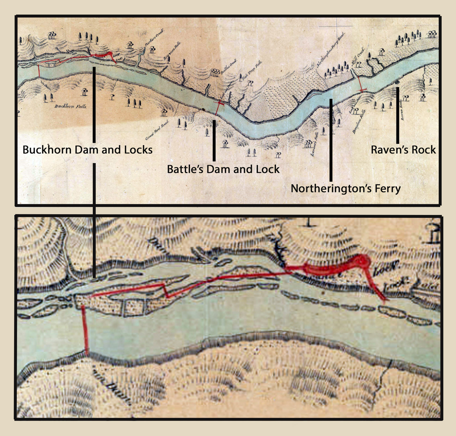
[Compare the image above to the linked google image. Do you see the two miles of canal? The article continues, telling of the boat passing through one of the two locks at the base of present day Buckhorn dam.]
At one Lock on this canal, within range of the eye I noticed a greater variety of woodland growth than is usual viz: Mulberry, Cedar, Sycamore, Oak, Elm, Willow, Pine, Chestnut, Chinqupin, Gum, Beech, Birch, Poplar, Hackberry, Hornbeam, Persimmon, Alder, Pau Pau, Holly, Ash, Hickory, and Walnut, and undergrowth in the wildest profusion. Emerging from this canal into the Cape Fear, our eyes were greeted with lovely and majestic sights.
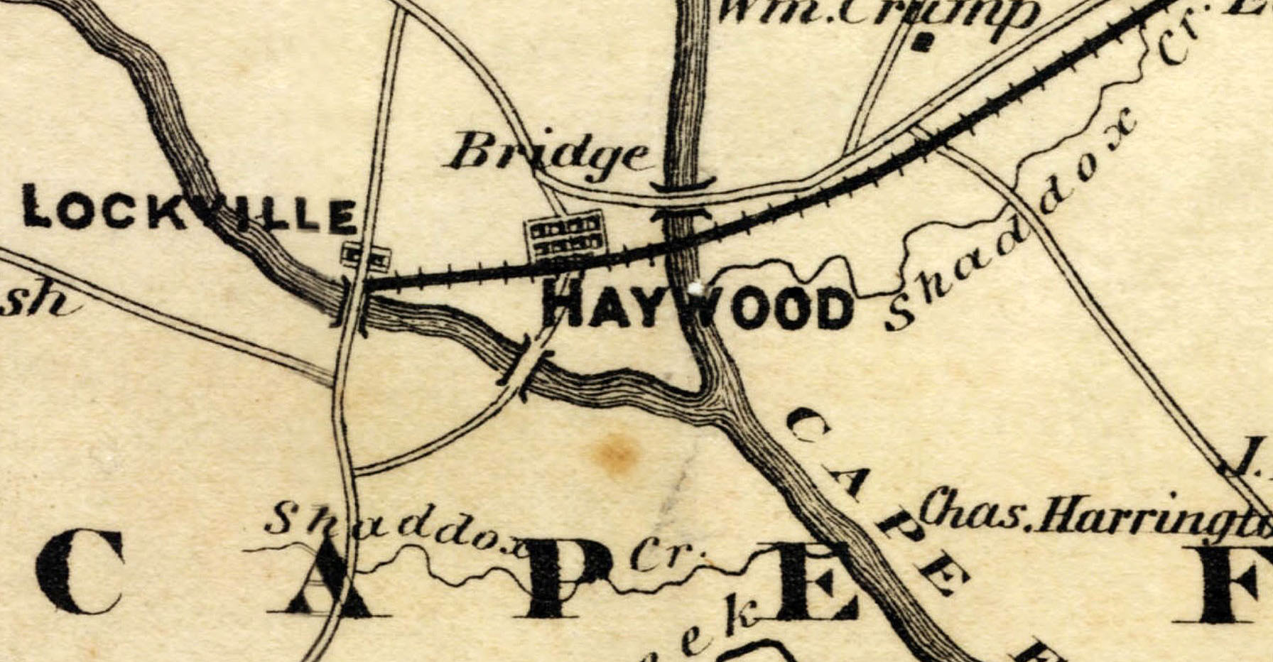
Towards the west, hill upon hill, clothed in richest verdure, met the eye. Towards the East, the rich and varied scenery of Buckhorn was bathed in the gorgeous colors of a setting sun. A broad and deep river lay before us to the ancient town of Haywood. Soon its inhabitants hailed us as we passed up Deep River to Locksville, the highest point to which Boats can now run. This is a place that formerly had a historic name and reputation. As Ramsey’s Mills, at which Cornwallis halted, in his retreat before Green after the Battle of Guilford Court House. Here Capt. Williams and the steamer Brothers, at sombre twilight, rested from the labors of the day. Click on Caption to see the full map!
I have thus briefly and very tamely attempted to describe the beauties of the trip. On Saturday we returned to Haywood, and found Col. Williams and Major Stedman, the Electors for the district, discussing the claims of Fillmore and Buchanan to the Presidency.
The town of Haywood consists of 260 acres of land, lying on the peninsula between Deep and Haw Rivers. The two principal streets are 180 feet wide. There is a public square embracing 8 acres. Immediately on the point of the peninsula, where the two rivers meet, lies a plantation containing some 300 acres, forming a fine extensive clearing. Standing for the first time on the grass-covered streets of Haywood, I could not help thinking on its past history, and its truehearted but now departed friend Judge Murphy, and both subjects formed strong examples of the mutability of human things and human schemes.
Nearly three-fourths of a century ago, a point 3 miles north west of Haywood stood prominently before the people of the State as a rival to Chapel Hill. It was by many deemed more suitable and more central as a site for the University of North Carolina. In the Legislature, Chapel Hill triumphed over Haywood by a majority of two. And again, in locating the Capitol of the State, on one ballot, Haywood but needed one vote more to have been the Raleigh of the good old North State. What effect a different location would have had upon the destiny and importance of the Cape Fear country and south eastern portion of the State, I will not attempt to describe. From one point on one of the principal streets in Haywood, there is a beautiful and extensive view of hill and dale, mountain gorge and glen. Following the course of the Cape Fear, the eye rests upon Buckhorn hills and McLean’s mountains, some 12 miles distant, whilst in a north west direction, the hill sides are visible some 4 miles. Running diagonally to this view, there is another, extending east and west some 8 or 10 miles, and but for two points of woodlands that thrust themselves into the range of the vision from the point on which I stood, near Haw River, the eye could embrace a range of 20 miles, and could luxuriate in admiring the oak covered crowned mountains of Wake and Chatham, as well as the pine covered hills of Harnett and Moore. What effect the navigation of the Cape Fear will have on Haywood, is beyond my ken to say; but Judge Murphy always maintained that its prosperity depended upon the happening of this event.
In my trip I had an eye to the useful as well as ornamental, and must confess I was agreeably surprised to find so many solid and substantial Locks and Dams upon the River. In common with most of our citizens, I have hitherto maintained that the Company should have commenced operations at Cross Creek and extended their improvements upwards, and I blamed Mr. Dobbin for not inserting that as a provision in the Bill extending State aid. But after going up and down the River, and observing the stability of Stone-packed Locks and Dams, as compared with Sand-packed, I have materially changed my opinion. Where rock was freely used, the works stand true and firm, where sand and clay were used, the Locks and some of the Dams are out of line, and careening to one or the other side. These defects the Company are now correcting and for that object keep the Haughton and six flats engaged in carrying rock from the quarries to the weakest points. The Brothers and Flat made the trip loaded, and never touched bottom except between Cross Creek Lock and Fayetteville. The whole line of works is in better condition than the public had been led to suppose. Having some idea of the rapidness of our river, and the force against which the works have to contend, we are therefore cautious in saying unhesitantingly that all the Locks and Dams will stand firm. Yet we do say, such is the amount of talent and art expended to break the force of those freshets, and so evenly is the force expanded over the whole surface, that we incline to the belief that the waters of the Cape Fear have at last been caught, bridled, and tamed. So that with proper caution on the part of Lock Keepers, and Superintendents and occasional repairs, there is not apparent reason why the work should not stand.
son is doubtful, but Corn, Wheat, and Flour, will find an outlet through this channel, either to Fayetteville or Wilmington.
The only obstacle that prevents Coal reaching market, is at Locksville – a point where a fall of 35 feet in 1 ½ miles had to be overcome. Upon this distance there are three contractors, two of whom will accomplish their tasks soon. The third it is supposed cannot, owing to changes in the plan, and difficulties not anticipated in the character of the work. To this point, however, the Company’s are now bending all their energies; and it is desirable they should succeed in transporting Coal to Marker before the winter sets in.
The Egypt Coal Mine is about 11 miles higher up the River than Locksville. Of this work you gave a detailed and interesting account in the Observer some time since – and account in which I supposed of so much importance that it would have found a place in our papers.
In company with a friend I called on McMcLane, and found him and his Lady exceedingly hospitable. In the morning we descended the shaft, and I can say I never descended one presenting more points of admiration, or evincing more skill in the Engineer and workmen. The timbers and sheathing were all strong and substantial. The workmanship seemed as perfect as is possible in a shaft; and what speaks volumes in praise of Mr. Mclane and his foreman Mr. Dunn, is that the shaft has been sunk 482 feet, the water pumps put in, a reservoir for water dug out, the Coal excavated about 100 yards from the shaft, and not the slightest accident has happened about the work – a fact that can be stated in their praise, and one that can rarely be said in reference to sinking a Coal shaft.
I tried my hand at digging Coal, and renewed a familiar acquaintance with the Pick.
It is a beautiful a vein of Coal as I ever worked; and if the navigation were but completed to this point, Exchange would soon be abundant in our midst.
B.

Wow, reading this took me on a journey through time along the Cape Fear River! 🚢 The vivid descriptions of the landscapes, from Raven’s Rock to Haywood, brought history to life. It’s fascinating how the author blends personal experiences with historical insights. Can any locals relate to the changing fortunes of Haywood and the impact of the Cape Fear’s navigation? 🌊 And who else wants to explore Raven Rocks now? 🏞️ #CapeFearHistory #LocalInsights 🕰️