
Have you ever seen a place name on an old document and wondered about its origin? Is there anybody out there who remembers the place and can tell us the story behind why it went by that name? Why does the place no longer go by that name and does its memory live on in any form or fashion?
The 1858 metes and bounds for Sarah Baucom Thomas’ dower states that her land lies “on the west side of Dumpling Road” (see a top of page ). I’ve wondered about this ever since the first time I read the document back in the 1990’s. I knew finding and locating this road was not likely, being the proverbial needle in a haystack. However, this Saturday I stumbled across the answer while reading through the few early surviving plat books.
My great-great-gandfather Ananias Thomas Senior had a son Ananias Thomas Junior. Born ca. 1847, Ananias Junior married Sarah Baucom, the daughter of Henry and Delaney Austin Baucom. Ananias Junior died 21 Feb 1858 and is buried at Edmond Davis cemetery in the community of Olive Branch, Union County NC. Dated 20 Dec 1858, Sarah received a committee allotted 52 ¾ acres being her 1/3 dower right to her husband’s estate lands. This indicates that Ananias Junior was in ownership of about 158 acres in total at the time of his death.
I figured the land on Dumpling road was likely near the cemetery. And, there’s a possibility that the land had passed down through the families of Thomas or Baucom. But where, exactly, was it? And where is Dumpling Road?
Dated 1 Nov 1940, the survey of J. B. Gaddy’s 131 acres is among but a few of the tracts recorded for New Salem. Looking at the plat below, note that Gourdvine Creek is located on the left side of the survey. There’s a stream called Haw Branch flowing west into Gourdvine nearer to the top of the survey. There’s also an unnamed stream flowing west near the bottom. From studies of surrounding lands I believe this stream is historically called Buck Branch.
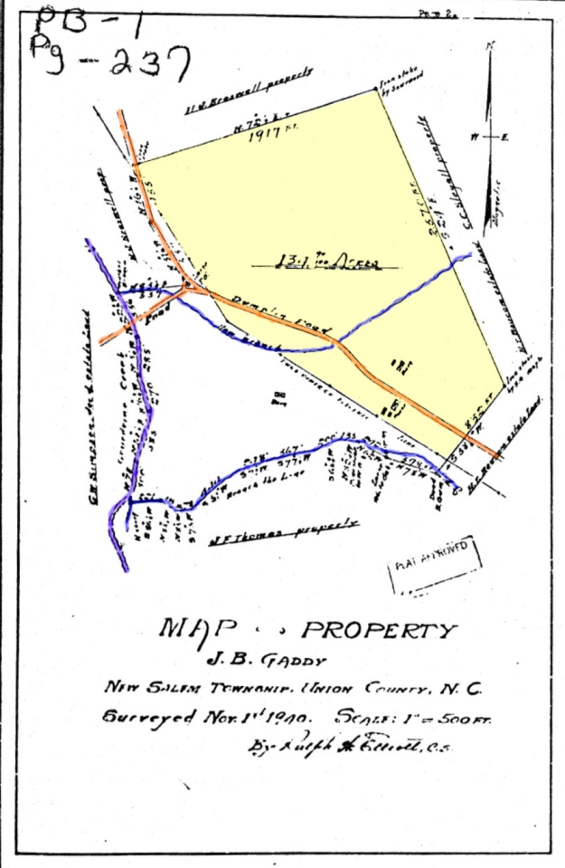
J. B. Gaddy’s 131 acre tract is highlighted in yellow. And, tinted brown and running through Gaddy’s tract is “Dumpling Road.” Note there is another road with ford crossing Gourdvine and Haw Branch before intersecting with Dumpling Road. I feel sure this is present day Holly School Road. Takee a look and compare to a present day topography map (below).

So, it appears that old Dumpling Road is the present day Hwy 218 that runs all the way to Polkton. Was the full run of the road referred to as Dumpling Road or just a small portion in present day Olive Branch/New Salem? And I still wonder about the origin of the name. Back then this must have been a place for some fine country cooking!

I Wii go to Olive Branch store on 218 and ask if anyone knows where Dumpling Road would have been only about 5 miles from where I live
It was for sure Hwy 218 on the east side of Gourdvine and likely to the west too. But would be good to confirm that.